Chart plotter anguish

The friendliest place on the web for anyone who enjoys boating.
If you have answers, please help by responding to the unanswered posts.

timjet

Guru
Joined
Apr 9, 2009
Messages
1,920
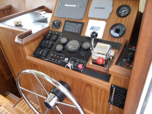
When I bought my boat a year ago I knew I was getting a somewhat dated electronic suite, but it appeared to be usable. It is a Raymarine chart-plotter and radar combo connected to a depth gauge and autopilot. The only issue I've had with it is having to replace the GPS sensor.*

The unit works well and was top of the line in it's day. But it's showing it's age. The chart plotter takes older C-MAP NT charts which Jeppesen is still supporting, but until when? They are expensive, about $199 a pop and cover a relatively small area. Screen refresh is slow which can be madding at times. The route line is so thin that it's difficult to see and info box's like ETA, ETA to next WP and arrival time cannot be displayed on the map page but are buried on page 7. Many of the functions are not intuitive and I compiled several pages of notes I keep handy on the bridge. But I love the big 10" screen and the radar works well though I still need to become proficient with it.*

My biggest complain though is the difficultly in transferring routes and way points created on my computer to the chart-plotter. When the unit was built there was no need for this transfer capability because no one had computers with charts on them. I've contacted Raymaine and a tech said there is a work around that involves manually connecting the chart plotter to a computer via some kind of wire. He's going to send me the instructions. He did warn me that this is a work around as the unit was never designed for this capability and it ain't gonna be easy.*

So I was thinking of just chucking the whole mess and starting new until I researched what it would cost to replace it. A comparable unit is in the $4M range, but much more capable and user friendly. After spending north of $15M getting this boat the way I like it, the electronics suite is going to have to wait. I thought I could salvage the radar and just buy a new chart plotter, but everything today is digital and the radar is analog.*

So this is my plan. Since everything is working and the only real issue is my desire to have the newest and greatest, I am going to work with raymarine to get the transfer function up and running. I have a garmin hand held gps with a tiny screen that I use as a back up. It does*display the info box's on the map screen and as long as I have my glasses handy I'm good to go.*

We're headed to Key West next month, so I'll have a change to really determine if it's drawbacks are really that important.*

Comments??

*

*
 
Tim, go on C-map's (jeppeson Marine) website or phone them.* They have a fairly inexpensive PC Planner program that allow for planning on a computer and transferring to your plotter.* It includes a device that lets you download direct to your chart chip.
 
Don, I'll check with Jeppesen and Raymarine again.

I have a RL80C built by Raytheon before the merger with Raymarine and uses HSB 1. It appears the HSB 1 is the problem. Perhaps you have the RL80C Plus which was continued after the merger but upgraded to HSB 2, which allows a computer connection.
Parts are no longer available to upgrade my unit to HSB 2 and even if they were I would not spend the $1050 to upgrade which is what Raymarine charged before running out of parts.

I'm waiting to here from the tech at Raymarine about the work around I mentioned before.
 
timjet wrote:
Don, I'll check with Jeppesen and Raymarine again.

I have a RL80C built by Raytheon before the merger with Raymarine and uses HSB 1. It appears the HSB 1 is the problem. Perhaps you have the RL80C Plus which was continued after the merger but upgraded to HSB 2, which allows a computer connection.
Parts are no longer available to upgrade my unit to HSB 2 and even if they were I would not spend the $1050 to upgrade which is what Raymarine charged before running out of parts.

I'm waiting to here from the tech at Raymarine about the work around I mentioned before.
*You're right Tim.* I have the HSB2 models.* However, you do don't load direct from the computer to the chart plotter.* The info is loaded onto a chip then the chip is inserted into the chart plotter and the data uploaded.*It may work on yours.* It's worth checking into.

I am very happy with my Raymarine set up, and see not reason to upgrade as long as it's supported.* The 4'open array radar is great.* The plotter and fish finder are great.* I can transfer to different screens and split screens.* From the days when I used an RDF to get home, this seems like science fiction.* My son has a nice late model*Garmen set up with radar and all, but I don't don't see any real advantage over what I have.

*


-- Edited by Moonstruck on Thursday 21st of April 2011 09:03:13 AM
 
Moonstruck wrote:
*You're right Tim.* I have the HSB2 models.* However, you do don't load direct from the computer to the chart plotter.* The info is loaded onto a chip then the chip is inserted into the chart plotter and the data uploaded.*It may work on yours.* It's worth checking into.

-- Edited by Moonstruck on Thursday 21st of April 2011 09:03:13 AM

*

*I think that's the problem, I can't load data via the chip the unit doesn't allow this. I think that's one of the main differences between HSB 1 and 2 and also the use of the NT vs NT+ chips. *I just got the work around from Raymarine. I will have to upload by using a serial connector from my computer and tieing in with the data input NEMA 0183 wires on my chart plotter. Looks pretty straight forward. I'm concerned about getting the software (Open CPN) to transfer data in a format that the plotter can read. I'll be talking to Raymarine again to get help with this.*
 
Hi Tim it has been awhile since you wrote this so maybe you have it all sorted out already.* We have a similar predicament in that the electronics on the boat are woefully outdated and we don't have the bucks to put in a whole new system.* Our boat has no chartplotter at all and the GPS is useless (per the PO "The GPS works, just the screen doesn't work" LOL).* The radar works fine and has its own display.* We were able to get one of the raymarine entry level A series chartplotters for under $500 after rebates at the boat show we had in this area last month.* For now we are maintaining the existing radar with its separate screen.* our someday plan is a whole new system with new radar, etc and then the A series will be a back up unit.* We don't build our routes on the computer and transfer them to the chartplotter so I've no idea if the A series can do this.

So my thought for YOU--do you have the room to keep your existing plotter as a radar screen and install the chartplotter you WANT next to it??* You could upgrade to digital radar LATER and get rid of the old chartplotter then?* Just depends how much real estate you have and how much you like overlaying your radar onto your GPS--which I guess you could still do.* might make the boat look pretty bad ass to have two chartplotters
wink.gif


Anyway, just a thought.
 
I'm baffled here guys so help me out but be gentle cuz I'm such an obvious noob.

When we bought Gray Hawk there was no chart plotter onboard.* I brought onboard a*7 year old laptop that we had lying around - so what's that worth - maybe 100 bucks?* And I bought a cheapo Chinese GPS/USB puck online.*I started out using Fugawi ($$$$) which is a whole 'nuther story but as soon as somebody wrote a Canadian chart plug-in for Open CPN I started using it and I just by gawd love it.* Its dead simple to use.* It works.* And for you Americans who never cruise in Canadian waters it costs ............ wait for it ..................... zero bucks.* That's right - absolutely bugger all, the square root of nothing, zip.

I seriously dunno why everybody doesn't use it.* I'm so happy with it that I've donated money to this forum, the cruisers forum where I discovered Open CPN and the opencpn.org site.*

I've got a huge screen c/w most chartplotters.* It refreshes quickly. I use it regularly and everything that I want to use is there with a right click - no long frustrating spells wading through multiple menus looking for something.* I've got some money invested in my Canadian charts but that's unavoidable no matter what you do.* Beyond that I've spent chump change.* Tell me what I'm missing.


-- Edited by bobofthenorth on Thursday 5th of May 2011 09:20:19 PM
 
Way to go Bob, we have a similar set-up.

I'm interested in your comment re Fugawi, I use Navionics Gold charts with Fugawi and have had no problems.
 
we use our laptop with open CPN down below but we only drive down there in bad weather. Trying to use a laptop on the flybridge is not practical and after using*Ray Marine chart plotters for*the past five plus years*IMO open CPM does not compare in ease of use.* IMO there is a reason it is free, sorry.* I'm not trying to be rude!!* Obviously everyone has their own preference and if it works for you, awesome.* What counts is we are all out there boating!!!*
smile.gif
 
I've boated (20 years in the SF Bay area)*with only compass and charts.

The thought of radar, gps, plotter, and depth finder is almost incomprehensible.* Let the adventure begin!


-- Edited by markpierce on Thursday 5th of May 2011 08:10:53 PM
 

Attachments

  • coot helm.jpg
    coot helm.jpg
    167.5 KB · Views: 110
I just recently started using Coastal Explorer and love it! I had previously been using Standard Horizon with C-map charts. I had bought the PC Planner for it and found it to be the most kluge piece of software I have ever seen. (and I was in the software business for many years). With Coastal Explorer you use the same data, the same computer and the same software to plan your cruise, create routes, make marks etc. Then you push a button and put it in 'cruise mode' and your off. Your charts are kept continuously updated for free, no waiting for the 'annual' release at $100 per chip! You can even download it and try it for free. It also has Active Captain that gets updated when you have internet access, that is activated right on the chart at the press of a button.

Normal disclaimer applies, no relationship other than a happy customer!

http://rosepointnav.com/default.htm
 
I am starting to look for upgrades, all the new stuff sounds so cool.
All those things you can do, and on one big colorful screen.
But then i think again, do i really need it?
My older Furono separate units work fine and if one goes down the others still work.
Am i going somewhere that i need to be able to transfer waypoints into the GPS? (i think mine can only be programmed at the helm) Not really. Do i use auto pilot: yes sometimes but the one i have works with what i have...

the only thing i would like to work better for me is a fish finder... so the question is, do you then go for a good separate fishfinder/sonar or do you get one with all the other bells and whistles?

So all of a sudden you have to rethink everything, the newer nicer fishfinders have built in chartplotters and you can overlay radar and connect autopilot, so back to pondering if i really need it that bad...
 
I prefer multiple separate systems. I am not a fan of single point failure.
 
Per wrote:
.......so back to pondering if I really need it that bad...
* * * ** That's really the question isn't it.* We, except for the pros who make their living on

******** the water, don't really need any of the bells & whistles, including the boat!


-- Edited by SeaHorse II on Saturday 7th of May 2011 10:24:35 AM
 
SeaHorse II wrote:Per wrote:
.......so back to pondering if I really need it that bad...
* * * ** That's really the question isn't it.* We, except for the pros who make their living on

******** the water, don't really need any of the bells & whistles, including the boat!


LOL but it sure is fun, including buying toys for the toy!* What do people who don't have boats DO with their spare time??*
confuse.gif
 
I purchased Coastal Explorer and a Com Nav autopilot and used them last summer. Now that I have CE providing steering info to the Com Nav auto pilot, the high level of attention to maintaining a course is reduced and I can monitor the radar, depth and VHF's better.

I was always a paper chart and compass navigator. Then I got GPS and started using waypoint navigation. Now, the labor of making a route and entering waypoints is muchly reduced. I always preached against letting the chart plotter steer the boat, but Coastal Explorer and Com Nav together steer a more accurate course than I ever could.

I do have two backup computers that can be substituted for the main, and I maintain courses and waypoints in a separate Furuno GPS. I also still get out the paper charts every day and verify that the courses steered agree with the magnetic compass.

There is a learning curve with the nav system, but overall, I am enjoying them and would not go back to the old way. Large ship captains have a helmsman, I have 'Otto' (the autopilot), to do the steering. Those same captains have a navigator, I have Coastal Explorer to mind the course and tell the helmsman where to steer. With the 'crew' keeping the boat on course, I can monitor the radar, depth, engine instruments, VHF's, AIS positions, and still enjoy the view.
 
Larry H wrote:
I have 'Otto' (the autopilot), to do the steering.
******** We used to call the autopilot "Iron Mike."

******* Welcome to the 21rst century!
 
I have 'Otto' (the autopilot), to do the steering.
******* " We used to call the autopilot "Iron Mike."

****** " Welcome to the 21rst century!"

Coastal Explorer uses the Microsoft voice called 'Anna' to anounce waypoint arrival and new course, shallow water ahead, possible colisions based on AIS data, and has settings in the program as to which to have 'her' report.** It is reassuring to me to hear 'her' announce the waypoint arrival and the new course, feel the boat turn onto the new course, and then to visually verify the new course on the compass!

The Star Trek Enterprise mode of full voice command cannot be too far in the future.

*
 
I must admit that is the one thing I will not submit to. Plotter controled auto pilot.
If a course change is not made or wrong at least i only have myself to blame.
It is too easy to get distracted and not check at the relevant time.
Just my 2 c worth.
 
Benn,

I said the same thing before I used the CE program. Of course, you cannot leave the helm on automatic and take a nap, supervision is still required. The CE program can be set to notify you when the waypoint is reached, but not make the turn. The voice will tell you that you have arrived and what the new course is. If you do become distracted watching whales or whatever, the voice is a reminder. I would suppose that other chart plotters have a waypoint arrival alarm. The program also has a digital readout showing distance and time to go to the waypoint. These functions were shown in my old GPS which did not have a plotter. I would not want the program to steer the autopilot at a waypoint without a notification.

When I started using the CE program, I activated the course, and set the autopilot manually, and changed it manually at each waypoint. Here in the Pacific Northwest, we have a lot of current, which can vary along the course. Using the autopilot manually, I had to correct for the current set a lot. This resulted in the boat always being slightly off the course line. The CE controlled auto pilot mode is a lot more accurate, and corrects constantly to keep the boat on the line. This makes the radar observations more accurate, and lets the other boats see my course more accurately.

One of the great features for my area is showing the AIS targets and their predictor line on the screen. The predictor line is a dotted line extending ahead of the target, showing where it will be in the future if it maintains the same course and speed. I set the predictor lines for both the AIS targets and my boat to 10min. (its adjustable) This allows me see if there are any conflicts coming up with a tug and tow or a ferry, and make course adjustments early. Seeing the AIS targets and their names also allows me to call them directly by name on the VHF if there will be a problem. When I am crossing with a ferry, and I am the stand on vessel, I usually call them and tell them I will cross behind them. The ferrys in WA and BC have enough to worry about without having to yield to a yacht.
 
Larry H

I to boat in the PNW. I have all the bells and whistles. I'm with Benn and SoF. There are too many logs, small vessels like kayaks, whales*etc that concern me so we keep a helm's person on duty at all times.* Not all large vessels operate their Class A AIS to be received by a Class B setup. Not to mention US and Canada regs on the Definition of "watch."
 
Sunchaser,

I DO NOT operate without a watch. Someone is on duty and maintaining watch at all times. I have found that my watchkeeping is actually better as I am relieved of the constant steering duty, and able to better monitor the water around the boat, and the various instruments. I can actually study the water ahead, with binocs if required, for logs, kayaks, skiffs, etc. without wandering off the course line.

My AIS unit is receive only, and receives both A and B. In US waters all commercial vessels over 300tons are required to broadcast AIS signals. In Canada, I have found many tugs that do not broadcast AIS signals. AIS is a great addition to safety as the signal can be 'seen' around corners and over islands, where the radar doesn't work. I consider my boat to be rather small at 37ft to be broadcasting AIS so I don't have a transciever. I think the smaller boats should keep a watch and use the AIS to stay out of the way or be aware of the big guys. Having AIS makes traffic monitoring easier. I still have one VHF set to the traffic channel, and the other to 16. Hearing the big guys report positions and then seeing their AIS signal on the plotter increases the safety factor. Canadian tugs not broadcasting AIS still require listening, logging, and radar confirmation. Last summer, I found many of the 70-80+ft yachts broadcasting AIS. Sometimes its hard to get clear of a large fast yacht or commerical boat when they are running fast and I can only make 7-8 knots.

I have been at this boating stuff for 30 years, I hold a USCG Masters license, and in my opinion, I am safer, and operate with a lower stress level with CE and autopilot to augment radar, VHF, depthsounder, and manual watch keeping.

I hope to see you 'on the coast' somewhere. Are you going north this summer?
 
SeaHorse II wrote:Larry H wrote:
I have 'Otto' (the autopilot), to do the steering.
******** We used to call the autopilot "Iron Mike."

******* Welcome to the 21rst century!

Back in 1981 when I had my trawler, I had an autoX.* I would line the trawler up on course, jamb a kleenex box in the wheel, and walk out and sit on the front trunk cabin.* Nothing happened fast on that trawler.* It was a better vantage point for a lookout.* Oh, for the simple life.
biggrin.gif
 
Pineapple Girl wrote:
Hi Tim it has been awhile since you wrote this so maybe you have it all sorted out already. *

So my thought for YOU--do you have the room to keep your existing plotter as a radar screen and install the chartplotter you WANT next to it??* You could upgrade to digital radar LATER and get rid of the old chartplotter then?* Just depends how much real estate you have and how much you like overlaying your radar onto your GPS--which I guess you could still do.* might make the boat look pretty bad ass to have two chartplotters
wink.gif


Anyway, just a thought.
*Hi Jennifer,

No I have not got this figured out. I got all the hardware hooked up but could not get the plotter to accept the routes from my computer. I think the problem is Open CPN the nav program on my computer.*

I decided to buy a Garmin 740 GPS which has a touch screen and I believe a 7" wide screen. After using it for 13 days on our Key West Cruise I like it, but it does not have some of the features I am used to, like a CDI ( course deviation indicator). But and hears what sold me, the touch screen. You can't beat it for qucikly finding info and route plotting. Gone are the days of using a track pad, thank God.*

It's a little pricy but the cheapest touch screen on the market I believe. It will display digital radar data, but mine is analog. Good for future use.*

I still use our old unit for the radar and chart plotter, it works fine, and when I get it to accept routes from my computer it will be great. The radar is invaluable as we were able to see the extent and size of a T storm as we were approaching an anchorage.*
 
Tim that touch screen sounds great!* when we are ready to really upgrade our electronics we will have to check that out.* Though by that time the*models will have all changed.

With people telling their names for their auto pilot, the one on our Sanata 30/30 GP (sailboat) was named Auto Van Helm.
wink.gif
* I look forward to the day we have a working autopilot on PG.* I have to agree it makes it much easier to keep a weather eye out while staying on course!!!* My*dear husband is notorious for tracking starboard when*he is trying*to check something out.* I, on the*other hand, just plain can't steer a straight line.*
disbelief.gif
* Luckily PG tracks pretty well!
 
These displays would be neat to have (and all the gear to make it happen).

232323232%7Ffp53985%3Enu%3D3363%3E33%3A%3E57%3B%3EWSNRCG%3D366%3A77779%3A336nu0mrj


*

232323232%7Ffp539%3B5%3Enu%3D3363%3E33%3A%3E57%3B%3EWSNRCG%3D366%3A777799336nu0mrj


*(Leaving Vigo, Spain)


-- Edited by markpierce on Saturday 21st of May 2011 01:22:47 PM
 
Pineapple Girl wrote:
* I look forward to the day we have a working autopilot on PG.* I have to agree it makes it much easier to keep a weather eye out while staying on course!!!* My*dear husband is notorious for tracking starboard when*he is trying*to check something out.* I, on the*other hand, just plain can't steer a straight line.*
disbelief.gif
* Luckily PG tracks pretty well!
*I try and limit my autopilot use especially in channels which is most of the time. My planning hull does not track well below planning speeds on autopilot or not. Works great above 12 kts though.*

Mark,

Too much information. I'd probably run over somebody trying to decipher a display like that, but it sure looks cool. --- Rudder Economy????


-- Edited by timjet on Sunday 22nd of May 2011 07:17:16 AM
 
Tim we are usually in relatively open water so will have good conditions for the auto pilot. It showed signs of life yesterday so we are hopeful that it actually works.

I have to agree those screens mark posted would be info overload for me.
 

Latest posts

Back
Top Bottom