Hurricane Matthew?

The friendliest place on the web for anyone who enjoys boating.
If you have answers, please help by responding to the unanswered posts.
FOG, "Yard Salad" perfect description. I know exactly what you mean.

If you have a neighbor close enough, run a garden hose to his house, pick up a double female swivel at the hardware store, attach the other end of the hose to your house and back feed the water into your system until you can get the broken pipe fixed. Don't forget to shut off the broken pipe at the house end.

It's nice to be able to flush toilets. Remember, If it's yellow, let it mellow. If it's brown, flush it down. Actually that's only the rule if you're flushing by poring buckets of water in the toilet.

Ski in NC used the yard salad term before me and I thought it was clever so
re-used it.

Thanks for the tip on the double ended female garden hose. We use this trick from RV to RV to transfer water when camping in the California Sand Dunes. My other hobby when not boating.
 
NC continues with major issues and now a levee breach and 1500 or so stranded. The area hardest hit isn't that close to the ocean. Their problem was 10 inches of rain a week before they got 14 inches from Matthew. It's not surge caused but just volume of rain caused.
 
Spent Saturday night out on a Mooring in the upper Pamlico river (NC). 4 of us were out on the balls and stayed on our boats. 60mph winds were probably the max. It was a bit lumpy out there in my 28 footer, but got through it fine. Unfortunately a 36' sailboat 2 moorings down broke loose in the night and went into the railroad bridge. As the water got pumped out of the River from the North wind It came substantially out of the water, pinned at the bridge. Water came up, boat stuck and went under at the bow. Sunday Morning SeaTow showed up. At this point the bow was down and water up to the mast. They tried to pump her out (with a marginal pump) then tried to pull her off the bridge. Last I saw Sunday Morning she was under and SeaTow was gone. Sad for the owner who was temporarily living aboard, but not there during the storm....Sorry I can't upload my pics at this time..

Currently back in my slip. Tar River feeding the Pamlico is at flood stage and water is running through my slip at 5 knots. This will likely continue for another few days... Washington without power until Wednesday.
 
Last edited:
Mr. Matthew

Greetings from North Myrtle Beach.

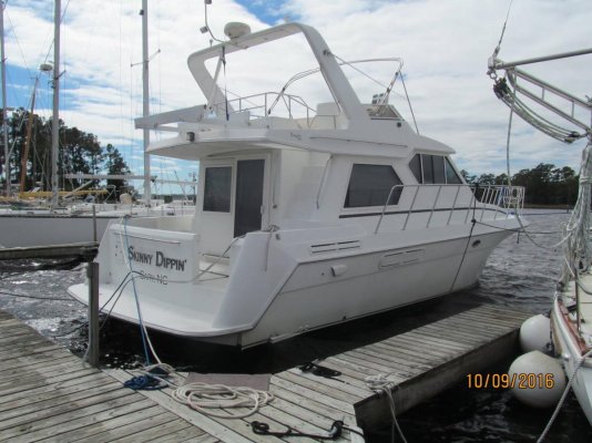
Been a crazy few days. Rode out Mr. Matthew on the boat. Pretty wild ride.
Rain started in sheets on Fri. (2-3” hour), kept up all day and night. Good way to find out if you have a dry boat (luckily, I had just re-caulked the forward hatch).

Saturday the wind started in earnest pretty early. In the afternoon we had a tornado touchdown at Briarcliff Trailer Park right across the waterway from me. The sky went very dark and it sure felt like the boat was trying to leave the water (all 20 tons of her). Very intense.

By mid-afternoon the rain was coming down sideways, and water was being blown off the surface of the waterway. Then the surge came in. The dock at Barefoot Landing went over its pilings, level with the road, and when the water came back down the dock didn’t come back down on the pilings. Substantial damage.

After what was left of the eye passed over us (right over us), all hell broke loose. When the backside of Matthew hit we really got our collective asses kicked! The wind held at a steady 40ish and then the freight train gusts blasted us. One guy with an anemometer said he clocked an 88mph monster. It was kinda weird because you could hear the gust coming and then a hard slam and the whole boat would shudder (shiver me timbers). This is when you start fretting whether you should have put the extra money out for the next size up dock lines. I had one of my dock cleats snap a horn. That’s a lot of power.

Fortunately, there is a safe shelter at the marina restrooms that we could go to if we had get off the boats. Still, not for the faint of heart. It was long, sleepless night.

The rain stopped in the evening and the winds dropped significantly after midnight. We lost power around 5pm, so the genny got a good workout. Finally got power back this morning.

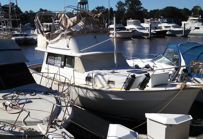
Fortunately, we had sufficient lead in time to prepare so there wasn’t much damage in the marina. Lots of folks came down to get their boats prepped. I saw some owners that I only see maybe once a year. After the storm I only saw one boat with its flybridge canvas and frame that got trashed and the guy behind me lost his bimini.

Things are starting to get back to normal, but it’s gonna take a while as there was widespread damage to the whole area. Cherry Grove was completely underwater (seawater) again, and we lost at least five piers.

So, we survived Mr. Matthew. I didn’t feel that I was in danger at any time, but I’m not sure I’ll ride out the next one. KJ

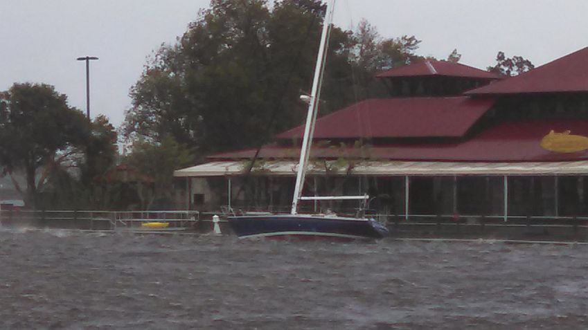
Welcome to Greg Norman's Australian Grill, you don't even have to get off your boat. Big wind.
1429-albums131-picture3257.jpg


Barefoot Landing dock.
1429-albums131-picture3258.jpg


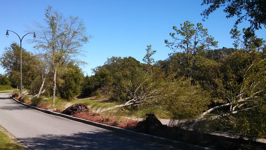
The road just outside the marina!
1429-albums131-picture3259.jpg


Bad juju.
1429-albums131-picture3260.jpg
 
We are at the top of the Chesapeake enroute south via the ICW. Is that still doable ?

Wallace, here's a report from Jeff Siegel of Active Captain on various spots, including the ICW and DS routes south. It sounds challenging for the next few days. It was great meeting you two on Saturday.

- - -

Harbor Town is reporting that their fuel and charter docks have been destroyed. Other concrete docks are also damaged. It's unclear whether they can accept transients - it'll take some time to figure that out.

Multiple marinas in the Hilton Head area were destroyed.

Isle of Hope (referenced below) is reporting minimal damage. Other marinas around there like Hinckley Savannah had all their docks wash away with boats on them. They've recovered the docks and are working on repair but we can all count on reduced numbers of transient spaces available between Southport, NC and Brunswick, GA.

Charleston is not without issues. The Maritime Center is reporting that they are destroyed. The City marina is reporting minimal damage. St Johns Yacht Harbor is reporting that T-heads and transient dockage has been damaged.

The North Landing and Centerville bridges (at the beginning of the ICW) are closed until the 15th (reported). The Dismal Swamp route has been closed with no projected opening date. The Annapolis Boat Show is over today with good enough weather for people to start leaving south. Many of them don't realize there is nowhere to go. Forecasted waves off Hatteras continue in the 8 foot level through this week.

The ActiveCaptain Facebook group has a pinned posting at the top with all reported and confirmed reports from north to south. There should be a new web page for reporting status and viewing all information in an organized way by tomorrow - that'll be reported in the ActiveCaptain Facebook group, The Marina Minute newsletter, and our weekly Wednesday newsletter. A team of people are setting up a calling system to talk to each marina between Atlantic Yacht Basin and Key West.

No minor inlet should be crossed until multiple confirmations are published. I would expect these inlets to be OK because of commercial and military traffic:

Southport/Cape Fear inlet
Winyah Bay inlet
Charleston inlet
Port Royal inlet
Tybee Roads/Savannah River inlet
Saint Simon Sound inlet
St Marys River inlet
St Johns River inlet
Cape Canaveral inlet
Ft Pierce inlet

None of them have been confirmed yet. AIS over MarineTraffic and ShipFinder is currently showing no traffic at all inland (very eerie) likely due to reporting stations being without power or commercial transit bans. You'll see those maps filled with ships all waiting offshore. Those AIS websites will be good sources for ship transit information for inlets.

The USCG had the most unusual of announcements - no buoys are to be trusted along the US east coast.

It's going to be a rather unusual fall cruising season...


...Jeff
 
For those wanting to know more about marinas and routes, then Waterway Guide has an excellent early summary. The Dismal Swamp is closed until further notice. The NOAA has an incident report document for the Florida Waterways.

https://marinedebris.noaa.gov/sites...way_Debris_Response_Field_Reference_Guide.pdf

Waterway Guide is going to issue a Waterway Alert document this afternoon.

They also have a document with reports from marinas in the area.

There may be markers that have been dislodged. Also, one thing I noted on the marinas is that many are not currently taking transients or more boats. Some because of damage. Some can't sell fuel. One the other hand there are many marinas that are open for all business as normal. I guess one thing I'd advise if heading up or down the ICW and in need of marinas to call them well in advance and find out their condition and the condition of water around them.

I would expect some debris where the Tar River, Neuse River and Cape Fear River flow into the coastal waters. They do have major flooding up river as they had a huge amount of rain a week before Matthew.

For events like this on the east coast, both Waterway Guide and Cruisersnet often are good sources of information.

Oh, just got Waterway Guide's alerts. There are several areas closed to navigation and some bridges closed. These would definitely impact anyone planning to come down the ICW all the way.
 
I have a friend who works with the savannah pilots. He said almost all of the channel markers are gone or some distance downstream of where they should be. The port of savannah was closed as well, last I heard.

For you guys headed south through savannah, we're at coffee bluff marina. It's small but very nice with concrete floating docks, Pumpout, water, gas, laundry, shower, small store, and at some point this fall, diesel. There was no damage here during the storm although I was afraid the docks were going to come off the top! ! Also, the most economical option around I think. A short trip off the icw but it sounds like most everyone else got rocked! !
 
Wallace, here's a report from Jeff Siegel of Active Captain on various spots, including the ICW and DS routes south. It sounds challenging for the next few days. It was great meeting you two on Saturday.

Thanks Ian ........ decisions, decisions !

There is an old Chinese curse ...... "May you lead an exciting life" :)
 
Looks like a lot of the ICW is closed down to South Carolina. :cry:

Ted
 
So much for leaving on Thursday. Maybe it's time for a Pocomoke river cruise till some of this gets sorted out.

Ted
 
If the ICW south of the Mason-Dixon line is anything close to what post SANDY was up here, you gents going south will be dodging debris for months to come along with un-charted shoaling........
Good luck and keep a sharp eye on the waters
 
Just very, very glad that our N.C. members seemed to have survived. We were worried about them! Yard salad can be cleaned up. Sunk boats . . . somewhat more of a problem.
 
I saw that the Dismal Swamp section was closed.
 
Ted... exactly what do you mean by closed?

By the USCG? Or just reportedly bad?

This is from the Waterway Guide special report:

Dismal Swamp Canal - Closed
ICW: Mile 15.2, Centerville Turnpike Bridge, closed due to Hurricane Matthew
ICW: Mile 20.2, North Landing Bridge, closed due to Hurricane Matthew
ICW: NC Border to to Albemarle Sound, closed to vessel traffic
ICW: Alligator River to Pungo River, closed to vessel traffic
ICW: Goose Creek to Bay River, closed to vessel traffic
ICW: Bogue Sound, closed to vessel traffic
ICW: Bogue Inlet to New River Inlet, closed to marine traffic
North Myrtle Beach, Little River Swing Bridge, closed to navigation
Socastee Swing Bridge, closed to navigation


Lots of bridges closed do to high water or other problems. Both Dismal Swamp and Albemarle and Chesapeake canal are impassable at this time.

Ted
 
I saw that the Dismal Swamp section was closed.

Probably leaving the locks open/closed to dump water from the lake and swamp....plus a few debris or downed trees could be an issue...
 
Last edited:
Ted! Looks like it's time to look at those stabilizers for outside adventures! Otherwise, you might never get here.
 
Ted! Looks like it's time to look at those stabilizers for outside adventures! Otherwise, you might never get here.

With or without stabilizers, I'm not going out around Diamond Shoals (Cape Hatteras) NC in the fall in a 7 knot boat! Neither Oregon inlet (Nags Head) nor Hatteras inlet are currently safe to navigate. Going from Norfolk to Morehead city (or maybe Ocacroke inlet) is just plain foolish this time of year!

Ted

I'm in complete agreement. I'll just keep plodding south til' I can't go any further and hope for the best.
 
Ted! Looks like it's time to look at those stabilizers for outside adventures! Otherwise, you might never get here.

That was going to be my suggestion is to consider running some of it outside. Still from the Chesapeake he has to deal with the Virginia Cut (assuming he doesn't want to do a long run around Hatteras) and even there it looks like there may be problems.
 
While going outside may seem like a good option, near coastal is going to have lots of floating debris from the storm. It's going to be ugly for a few weeks to a month. Also, inlets may have lost some buoys and there could be shoaling that changes the channels. If you have the capacity to go way off shore and only use large commercial inlets or avoid the inlets until you reach your destination, then outside may be an option. For most of us traveling South, this time of year isn't an option for the off shore run.

Ted

I understand. Last year when the floods came we pretty much followed Capt Bill home as he ran straight from Charleston to Fort Lauderdale and we ran the next day from Georgetown to Fort Lauderdale. With us, it was just get us out of this. We didn't see as much in the way of debris as expected, but every storm is different. Coming from the Chesapeake south right now, just seems to be a bit like wading through a mine field. We'd still do it, but carefully and prepared to stop at any point anytime if we felt it was warranted.
 
Just very, very glad that our N.C. members seemed to have survived. We were worried about them! Yard salad can be cleaned up. Sunk boats . . . somewhat more of a problem.

We should have checked in too! Skinny Dippin is good to go! We lost power here at home for a day and a half, no damage. Flooding between here and there may keep us away from the boat for a little while. We'll see.
 

Attachments

  • IMG_0380.jpg
    IMG_0380.jpg
    142.1 KB · Views: 45
Floating debris should be cleared out pretty quick, and if not, they are at least floating.

Sunken hazards will be recognized in many areas pretty quick....by the sheer volume of traffic.

Within a few days, recreational traffic will increase as I would guess commercial is already plying parts of the ICW. The USCG will be making aid surveys and have to run many of the skinny parts of the I CW.

Wander away from the channel like after Sandy and no telling what you may find in areas that had major wash through, but my guess and hope is that the channel will be relatively free of debris and some sand bard may have shifted .

A few brave souls should be reporting in as the days go by.
 
....The USCG will be making aid surveys and have to run many of the skinny parts of the I CW...

I talked to the USCG from Mayport on Sunday afternoon when they were at the boatyard. They had already done the aids to navigation for our area, though I'm not sure what our area encompasses but it sounded like they were right on it.


Debris is another issue. Yesterday, there was still a lot of junk floating down the St. John's.
Larry, is it tidal where you are discussing?

My experience is stuff sloshes back and forth as the high tides dislodge it from its first wash up and the clocking winds blow it back into the current.

Usually on most smaller rivers and coastal creeks, after a dozen or so cycles with some strong clocking winds or one particular high tide and the larger debris drop off dramaticalky.

But some long rivers always take a bit longer...depending on how quickly they drop in volume.
 
My experience with shoaling in many hurricanes... is that sand does not move too much. Unless a new inlet opens up, then everything changes fast.

During the storm the water is high and inlets deep. Current usually is not moving that fast so not much sand is moving.

I go out on my jonboat and survey my inlet, Mason's, at the N end of Wrightsville beach after each 'cane. Usually sand is mostly where it was prior. This is an unmarked inlet, but usually deep enough for my 38 to get out. Saves a heck of a lot of time over going all the way down to Masonboro. 1mi to ocean vs about six.

We get more sand moving on lunar tides when it gets real low.

You guys be careful at green can 123. As usual it is shoaling bad on SE side of channel and if you get close to the can you are going to eat it. Hug the docks. This was going on before the storm.

I have not done the jonboat survey yet, waiting for water vis to improve, will take a few days. Will report back.

The Coasties need to move the can again. Seatow and BoatUS are licking their chops for the fall migration, again.
 
Last edited:
Back
Top Bottom