Electronics for a Minimalist

The friendliest place on the web for anyone who enjoys boating.
If you have answers, please help by responding to the unanswered posts.
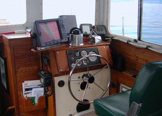
I'd suggest looking at Garmin, given what you are looking for. The ipads and apps and other things will get you minimal cost, but that's not your prime objective. And they will be limited in their ability to expand (adding radar, sounder, etc), and I think result in a messier installation with exposed wires, etc.

From everything I've seen, Garmin provides a very clean and simple user interface that seems to click with people who are less tech savy. I'd plunk yourself down in front of one and play with it for a while and see if it clicks with you.

I think the advantage of a Garmin (or any vendor) multi function display is that you can make it as simple or complex as you want. With Garmin, there is one source for charts, so simpler than having to pick with other brands. You get a daylight bright screen, DC power, and a clear installation with no exposed wires etc. You can start with just the chart plotter and either and external or internal GPS receiver. I'd also highly recommend a depth sounder (the depth will display on the Garmin, you just need a transducer to sound the bottom.) Later, if you decide, you can add Radar or whatever you want.

I'm suggesting Garmin over Simrad and Furuno for a few reasons. First, as I said earlier, the Garmin interface seems to appeal most to people new to boating. But if you find Simrad or Furuno's interface "speaks" to you better, that can sway which brand you pursue. I'd favor Garmin over Simrad because I think you are much less likely to encounter problems, bugs, and odd behavior on the Garmin. And I'd suggest Garmin over Furuno because I think Garmin's design places the user interface as it's first priority. Furuno I think has the most sophisticated functionality, but is still a pretty clunky interface as compared to other.

I haven't mentioned Raymarine mostly because I just haven't looked at them for many years. On paper they have very good functionality, but so does Simrad. What really counts is the implementation, how easy YOU find it to operate because our brains all work differently, and how buggy the product is. This is where Simrad falls way behind. If you find yourself leaning towards Raymarine, I'd suggest doing a lot of owner research to see what sorts of problems people are encountering. Ray seems to be most popular in Europe, and with the sailing crowd.


Great reply....thanks
 
I have a binnacle style compass, Eagle 350c color fisheasy modded to work with a Garmin 6 pin bronze thru-hull transducer, and a NAV PC running openCPN using cmap and NOAA ENC charts. Forgot, I also have an old SeaCom VHF that has a telephone handset for the mic. It is real clear sound too. I can click a switch so that it is private.

I built the PC as a core2duo 2.3 ghz all with used parts off ebay, for maybe $100 total.
For the OS I use Linux Mint.
I had a copy of cmap ENC charts, but you can use free NOAA ENC charts.
I got the LT-20 Delorme USB GPS for $20 off ebay.
I got the Eagle fish easy for $20 off ebay.
I got the bronze thru-hull Garmin transducer for $60 off ebay, had to carve my own wood fairing to fit to the hull.

I use a standard style Samsung 17 inch monitor, screwed down to the chart table thru it's base with one screw.

I located the PC 15 feet away.
Connected the monitor using a 25 foot HDMI cable.
I ran a 15 foot USB cable to a USB 3.0 7 port hub.
To the hub I attached keyboard, mouse, gps.

It all works fine. Modding the Eagle to work with Garmin was the hardest thing, but I really liked both the Fish Easy and the Garmin transducer. They are the same hertz, but had mod the resistance of the temp circuit in the fisheasy with a series POT inline.

I liked it so much, I did 2 of them, which allowed me to also use the older 7 pin thru-hull transducer already in the hull. The depth reading is the most important one, not the fish finding.
Album of those mods.
https://goo.gl/photos/sBZ4TPJZZsGDRrZBA

Very neat...but not for me. Thanks for the reply.
 
wannabe,
Here's my minimalist system.

When I bought the boat there was a very good compass, a fishfinder/sounder and a VHF.

I added a dedicated JRC radar, a dedicated Garmin chartplotter and a really good Raymarine sounder.

That's all I have and in almost 10 years I've not wished for more. There are improvements in the VHF and chart plotter I'd probably like but I get along fine w what I've got.

I also travel w my i-pad on an app called Navamatics. It's downloaded so I keep it plugged into a cig lighter DC power source while underway. I surf ahead for anchorages, towns and interesting places like going between an island and something else or other navigational points of interest. I can thus look at charts afar (in great detail) and keep tabs on what's right ahead of the boat. The trick is to not get so engrossed in the i-pad Navamatics that I miss seeing a log in front of the boat.
 

Attachments

  • STH71154 copy 3.jpg
    STH71154 copy 3.jpg
    109.7 KB · Views: 48
I think the biggest problem is you haven't clarified what minimalist means to you. Do you want all the bells and whistles but with a single screen? Go for one of the big guys packages. Do you want a simple to use system with the basics? Grab a tablet and throw navionics (or the app of your choice) on it.

What is your boating experience?

What sort of cruising will you be doing? You don't need much if you only leave the dock on sunny days. If you plan on cruising to Alaska or Mexico then that might change the game. I do all my navigation on my tablet or even on my phone if I'm in familiar waters.I use my depth sounder to confirm the contours. AIS is high on my wants list followed by radar. I've gotten by without them for this long I'll probably wait until I buy my next boat. Forward looking sonar? FLIR? Some people might think they are in necessary and if we're spending your money then....

To answer your questions:

What I am trying to achieve is a simple clean look with now exposed wires and a little "clutter" in and around the helm station as possible.

I am not a total newb but by no means a salty veteran either.

Coastal cruising between WA and central/north BC for the time being.

Thanks for your thoughts...appreciated.
 
If Apple makes any marine navigation equipment it's news to me.

I would go with Garmin and the biggest display that will fit into your helm. Pretty simple and feature rich.

I did not imply Apple makes any such thing...

I was simply giving an example of the types of gear I like and use to help people understand the kind of technology I am comfortable with is all...I thought that was pretty clear :blush:
 
What I am trying to achieve is a simple clean look with now exposed wires and a little "clutter" in and around the helm station as possible.


You can actually incorporate a lot of capability, into one clutter-less MFD (multi-function device), if you choose to do so. Most of the companies offer something where sensor data -- depth, radar, AIS, weather, wind, etc. -- and maybe an autopilot can be displayed on (and controlled from) a single display monitor.

Which also address iPad issues like daylight visibility, water resistance, heat resistance...

Needs some networking, but if your helm station allows a flush, flat panel installation, no wires need be visible.

There's potential trade-off. If that single display craps out, you've got squat for depth, radar, AIS, weather, wind, and AP info/control.

-Chris


-Chris
 
If you want clutter free, go with a single Multi Function Display (MFD) that your radar and everything else is connected to. Go with as big a screen as is comfortable at your helm. Then connect everything to the MFD via NMEA 2000 buss. That way you can get rid of those pesky engine instruments (just display engine parameters in a sub window) and other clutter at the helm. Hmm, maybe you could even go with electronic steering integrated to the MFD and get rid of the wheel and thruster joy sticks too. If your MFD has wifi you could get apps for your phone to run the boat and monitor everything. :D
 
Keep in mind, reducing displays AND reducing technical complexity is a paradox. The more functions you put into any one device, the more complicated that device will be to operate.
 
wannabe,
Here's my minimalist system.

When I bought the boat there was a very good compass, a fishfinder/sounder and a VHF.

I added a dedicated JRC radar, a dedicated Garmin chartplotter and a really good Raymarine sounder.

That's all I have and in almost 10 years I've not wished for more. There are improvements in the VHF and chart plotter I'd probably like but I get along fine w what I've got.

I also travel w my i-pad on an app called Navamatics. It's downloaded so I keep it plugged into a cig lighter DC power source while underway. I surf ahead for anchorages, towns and interesting places like going between an island and something else or other navigational points of interest. I can thus look at charts afar (in great detail) and keep tabs on what's right ahead of the boat. The trick is to not get so engrossed in the i-pad Navamatics that I miss seeing a log in front of the boat.


That's a great looking set up Eric, thanks for sharing.
 
Thanks for all the great ideas and feedback. I appreciate everyone taking the time.


I think what makes the most sense for me is a Garmin multi-function display with depth displayed and a chart plotter for now. I like the idea of being able to add radar when and if I choose.I will also keep an iPad with iSalor (and maybe some other apps) as back up and of course I also have an iPhone which can run the same apps if all else fails so I feel pretty good about my redundancies. And of course I will have a modern VHF and a handheld as a back-up. I will ensure I play with a Garmin at the next chance I get to make sure it’s for me but it certainly sounds like a great and likely option.
 
Last edited:
If you are ever down in Bellingham give me a ring and I will show you exactly what you are looking for as that is how it installed on Ebbtide.

I will PM you my number.

Bob
 
We have a Garmin 2010C Chartplotter that came with our boat upon purchase but cannot be updated according to Garmin. My question is, "does anyone use a Macbook Pro with Garmin BlueCharts"? I have read through many of the discussions and see many iPad users (I have an iPad 2), but do not see anyone using a MacBook Pro.
 
Hi MM,

Our 26-footer has a Garmin 2006C, just like your 2010C except for screen size. Bought new in 2002. Updated its software a few times over the first several years we had it, and have had no need to update since. Still works very well.

Updated the chart chips a few times too, but not in the last several years. OTOH, we cruise the Inside Passage, and the rocks there don't move around very much....
 
Garmin does not work on a Macbook Pro. However Garmin works great on the iPad.
 
A hard case minimalist compass-chart-binoculars vhf radio. Add depth finder if you are up for one electronic device. I navigated on East cost for over 20 years with that set up and only got slightly lost at night once on my first long trip at Plum Gut entrance LI Sound which resolved after I found a buoy and hove to until day light.
 
VHF (existing hard mount both stations)
Bad Elf GPS Receiver (Bluetooth)
Navionics
iPad for Navionics (iPad Pro 12.9")
Furuno DRS4W First Watch Wireless Radar
iPad for Furuno radar app (an old one I had)
Raymarine T111Multifunction Wireless Dual Display (Speed / Depth)
Raymarine ST6000 Autopilot (also old)

Yes - I have a hard mounted Raymarine (old) depth sounder on the flybridge, a decent Garmin GPS, and recently removed Raymarine (old) analog radar. I have a hard mount compass at both stations.

I did this so I could have exactly the same instrumentation at both stations - and everything is wireless - and we can be anywhere on the boat and know what is going on in real time... and it can all be taken inside and locked up. We're not passage makers and it suits us just fine. And everything totaled under $2500.

mike
 
Last edited:
Thanks for all the great ideas and feedback. I appreciate everyone taking the time.


I think what makes the most sense for me is a Garmin multi-function display with depth displayed and a chart plotter for now. I like the idea of being able to add radar when and if I choose.I will also keep an iPad with iSalor (and maybe some other apps) as back up and of course I also have an iPhone which can run the same apps if all else fails so I feel pretty good about my redundancies. And of course I will have a modern VHF and a handheld as a back-up. I will ensure I play with a Garmin at the next chance I get to make sure it’s for me but it certainly sounds like a great and likely option.

Wannabe - I think you are on the right track with a Garmin MFD. You can integrate as much or as little as you want. (radar, autopilot, engine gauges, depth sounder) . I've found the Garmin package to be very intuitive and reliable.
 
VHF (existing hard mount both stations)
Bad Elf GPS Receiver (Bluetooth)
Navionics
iPad for Navionics (iPad Pro 12.9")
Furuno DRS4W First Watch Wireless Radar
iPad for Furuno radar app (an old one I had)
Raymarine T111Multifunction Wireless Dual Display (Speed / Depth)
Raymarine ST6000 Autopilot (also old)

Yes - I have a hard mounted Raymarine (old) depth sounder on the flybridge, a decent Garmin GPS, and recently removed Raymarine (old) analog radar. I have a hard mount compass at both stations.

I did this so I could have exactly the same instrumentation at both stations - and everything is wireless - and we can be anywhere on the boat and know what is going on in real time... and it can all be taken inside and locked up. We're not passage makers and it suits us just fine. And everything totaled under $2500.

mike

I think the iPad is the proper marine electronics refuge for cost, simplicity, diversity, innovation and power, and for emerging platform maturity. The rest I leave to the competition. (Disclosure - i make iPad instrument enclosures, but plead innocence).

Available in February and would love to see some marine installs.
Poort-prototype.jpg
 
Last edited:
We have a Garmin 2010C Chartplotter that came with our boat upon purchase but cannot be updated according to Garmin. My question is, "does anyone use a Macbook Pro with Garmin BlueCharts"? I have read through many of the discussions and see many iPad users (I have an iPad 2), but do not see anyone using a MacBook Pro.

I have been very happy using MacENC with MacbookPros (now on my second unit, I get about 5 years out of one) for about 10 years. Excellent support. I like the looks of both OpenCPN and Polar Navy from seeing them on other's machines, if you are especially cheap.

Here is a good archive of discussions regarding using Apple devices for marine purposes.

Forum Index - MacSailing.net - Powered by FusionBB
 
Thank you for the MacENC info - I think that will be very helpful
 
Garmin does not work on a Macbook Pro. However Garmin works great on the iPad.

Garmin Blue chart works fine on my MacBook Pro, but need the chart data plugged in.

However, it's too cumbersome for use on the helm and screen display not bright enough. Would be good for using inside, in the planning area.
 
I think the iPad is the proper marine electronics refuge for cost, simplicity, diversity, innovation and power, and for emerging platform maturity. The rest I leave to the competition. (Disclosure - i make iPad instrument enclosures, but plead innocence).

Available in February and would love to see some marine installs.
Poort-prototype.jpg

What sizes will this facilitate? Nice product and great idea.

Does anyone have a good preference for a USB power bar that plugs into a 12V outlet? Need to keep the iPad units charged.

mike
 
What sizes will this facilitate? Nice product and great idea.

Does anyone have a good preference for a USB power bar that plugs into a 12V outlet? Need to keep the iPad units charged.

mike

The present Poorts fit only the standard 9.7" iPads, any generation. Or the Samsung S2 9.7" tablet, for a shipboard fixed cellular phone, or a kitchen phone like in the old days? When they are mounted over a countertop 110V outlet, Poorts can hide the outlet and any cables, and they are always charged.

For marine installs the car usb adapter that plugs into the cigarette lighter slot, also common on boats, is the simplest approach. This dedicated 12V one looks cool: https://goo.gl/ejs5Dr

-Dwight
 
Last edited:
Oh baloney!

More equipment doesn't make you a better navigator.

To the OP, just get a system that has its own network and display everything on your iWhatevers.

You are correct, my sons & I sailed from Cape Cod, MA to Trinadad and back stoping at hundreds of islands using compass, paper charts and a Garmin 120. Instruments do not a navigator make.
 
Originally Posted by Capt.Bill11 View Post
Oh baloney!

More equipment doesn't make you a better navigator.

To the OP, just get a system that has its own network and display everything on your iWhatevers.
You are correct, my sons & I sailed from Cape Cod, MA to Trinadad and back stoping at hundreds of islands using compass, paper charts and a Garmin 120. Instruments do not a navigator make.[/QUOTE]

Ageed,

More equipment doesn't improve your skills, but SURE improves your capability for a voyage, especially when the equipment give you info that you didn't have.

I could argue strongly to have a quiver of good equipment that gives you more info, which equates to a safer and more comfortable passage.

Some of these devices include a good GPS map, radar, depth and sonar capability, weather input, and a bunch of others. ,

The best navigator can still be blind without good info.

I'll take the equipment anytime over blind luck, or a guess.
 
I don't know about you guys but I love electronics. If we had the money I'd put a whole suite of new chart plotters, echo sounders, radars, flir and what ever else I could find. Why? Because it's more fun to play with all that stuff. I can navigate anywhere you like with a magnetic compass, paper chart etc but where's the fun in that.

Does all this electronic gear make it safer or easier. Absolutely if you know how to use but if you don't it can be a dangerous distraction in some situations where you should be keeping a proper look out.

If we had to go the minimalist route somthing like the Simrad GO9 that will do almost all you want in a chart plotter and echo sounder. You can add radar to it later and have a second station with an IPad. Might be worth consideration.
 
Last edited:
I don't know about you guys but I love electronics. If we had the money I'd put a whole suite of new chart plotters, echo sounders, radars, flir and what ever else I could find. Why? Because it's more fun to play with all that stuff. I can navigate anywhere you like with a magnetic compass, paper chart etc but where's the fun in that.

Does all this electronic gear make it safer or easier. Absolutely if you know how to use but if you don't it can be a dangerous distraction in some situations where you should be keeping a proper look out.

If we had to go the minimalist route somthing like the Simrad GO9 that will do almost all you want in a chart plotter and echo sounder. You can add radar to it later and have a second station with an IPad. Might be worth consideration.

my boat has plenty of electronics and back ups. I keep in mind that a fully staffed navy ship ran hard aground running on a electronics package and that type of thing is not all that rare. Paper charts good binoculars a corrected compass and a depth finder are what I ultimately rely on inland and coastal.
 
my boat has plenty of electronics and back ups. I keep in mind that a fully staffed navy ship ran hard aground running on a electronics package and that type of thing is not all that rare. Paper charts good binoculars a corrected compass and a depth finder are what I ultimately rely on inland and coastal.

Agree with most points here, and often less is more. Personally I am amazed as to what can be bought these days, especially in the solid state realm for fairly reasonable amounts of $. If someone is willing to spend the practice time, these newer systems are very user friendly.

Question - if you are running at night, which I assume you must do once in awhile, how do you get a fix to DR/plot with your paper chart and compass?
 
Back
Top Bottom