Hurricane Matthew?

The friendliest place on the web for anyone who enjoys boating.
If you have answers, please help by responding to the unanswered posts.
Parks. You on a perfect part of the river, I'm at 27 avenue where it is wider and fewer building to block the wind. I'm sure our boats will remain safe as long as nothing floating does any damage.

Good luck.
 
There are quite a few factors that go into surviving one of these storms.....navigable semi-circle which for boats inland just means survivability at the dock....and is a HUGE factor right now for the US Coast. Also is the radius of hurricane force winds.

Seems like a lot of parroting of weather forecast sites or television programming.

In the proper hole...surviving a cat 3 or 4 might be no big deal....in the wrong spot, 50 mile an hour winds can wreck your boat.....depending on duration....and that is a huge deal in itself.

Surge is a story unto itself if not right on the beach.

Nice to keep abreast here...but great advice and reprinting what most of us can look up on the internet is interesting itself.
 
Last edited:
look like Matthew going to arrive tomorrow middle day in Florida, hop all your boats are secure and you going to be in safe place.

Good luck and be strong

Hugues
 
If you follow the media reporting on this or any other hurricane they are really drama merchants and make it appear much more important than it is. The reporting after the storm always shows the worst, most destructive photos they can find. They are in the business of selling. My boat is on the Miami River and I've doubled the spring lines and taken in the cushions. I have confidence the boat will be fine.

Agreed, far too often they are drama merchants.
but maybe not this time.
 
Hate the thought of returning to 2004-2005 like "plywood state".
 
Bigfish did you notice the tide was very high this morning on the river?
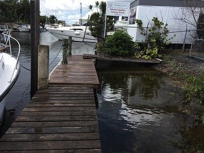
Here is a photo of my fixed dock and floating dinghy dock. The dinghy dock is usually several feet below the fixed dock.

Darn it. Will someone turn that right side up for me please?
I don't know how to do it.
 

Attachments

  • IMG_0853.jpg
    IMG_0853.jpg
    190.6 KB · Views: 76
Last edited:
Parks. Yes it was very high until about noon. I've seen it higher and unfortunately it will be high tomorrow when the winds start, I hope my fenders work and won't ride over the dock. The Fisher Island ferry even come up the river today. Some of the island freighters left. Should be fun tomorrow. Good luck.
 
Following this storm with great interest - for what I can learn - and cause I just love the coastal boating - good and challenging.


Sold our boat in the summer - wasn't planned - not on the market - but an offer materialized - knew that we would be wanting to be out of it in the next year.


Where I kept the boat is on the lower edge of the concern area. Watching this storm - alternating between what if I still had a boat there vs - backing off just learning.


Our thoughts and prayers to all who are in the affected areas. If I could help - I would.


Mark
 
Our thoughts and prayers are with everyone in its path. Stay safe!
 
Thanks Bigfish, Manny is going to open the store tomorrow at nine until the weather gets bad or he runs out of customers.
 
Agreed, far too often they are drama merchants.
but maybe not this time.

Also agree, but they are also often wrong. What about if they're wrong again and this time have underdraumatized it.:confused: Anyway, I'll feel a lot better if in a couple days I can say once again, "yeah, they over dramatized it". I'll take drama to trauma anytime.
 
Last edited:
I am sitting at Prague airport waiting for my flight back to JAX. Moved it up a day and hope to get in this evening.

The missus has Sonas as prepared as she can. Doubled the lines and put all fenders down. We have the lagoon lock to stop any surge, so it will be a wind event for us.

Only decision when I get in will be the flybridge Bimini canvas.
 
He mentions an 8 foot storm surge.

Track update: Still heading for Florida coast
Matthew continues heading on a northwest track that will take it just west of New Providence Island, putting Nassau in the most intense part of the storm’s dangerous right-hand side. However, Matthew may head just far enough west to avoid the worst-case impacts for Nassau, most likely tracking over parts of Andros Island. Unlike the mountainous parts of eastern Cuba and western Haiti that took a toll on Matthew as it crossed them, Andros is a very flat island, so it should have little or no effect on the storm.

Should Matthew continue on its due-northwest track, it would come uncomfortably close to making landfall along the urban corridor from Miami to Palm Beach. Our most reliable track models insist that Matthew will begin angling just to the right before landfall, which would keep the southern part of this corridor on Matthew’s weaker side. Broward County (including Fort Lauderdale) is in a hurricane warning, while Miami-Dade County is in a tropical storm warning. The risk of dangerous impacts, including hurricane-force winds, ramps up greatly from Palm Beach northward. The most recent NHC forecast (see Figure 2 above) keeps Matthew as a Category 4 hurricane as it reaches the Melbourne area on Friday morning and a strong Category 3 by Friday evening just east of Jacksonville. The 00Z Thursday run of the GFS model agrees very closely with the official NHC track. Hurricane Warnings are now in effect from Broward County to Fernandina Beach, Florida, with a Hurricane Watch extending northward to Edisto Beach, South Carolina.

If NHC’s forecast were to prove spot-on, conditions along Florida’s central and northern Atlantic coast could easily top anything observed in many decades. As we noted this afternoon, the Melbourne area--including Kennedy Space Center--has never recorded a major hurricane. Hurricane Dora struck near St. Augustine, FL, as a Category 3 in 1965, but otherwise the Jacksonville area and its 1.5 million residents have never experienced a hurricane of this magnitude. A northward-moving “coast scraper” hurricane has the potential to cause widespread damage over an enormous swath of populated area. In general, the storm surge threat with such a storm would be less than for a perpendicular landfall, but as the Atlantic coast begins curving toward Georgia, the risk of dangerous storm surge will rise markedly, with inundations of up to 8 feet possible from Sebastian Inlet, FL, to the Georgia/South Carolina border.

The bottom line: Matthew continues to pose a potentially dire threat to much of Florida’s Atlantic coast, with major impacts likely along the Georgia coast and potentially further north.
https://www.wunderground.com/blog/JeffMasters/matthews-shrieking-winds-hit-bahamas
 
Thinking outside the box for a moment....as hurricanes pass....winds shift. Plus the can be all over the place from turbulence, etc.

Thought about lowering your Paravane poles for less windage? I have been toying with the idea of connection ting them to heavy objects to also help any rocking in the stands......not convinced...just thinking....

The paravanes are staying up. All the rigging has already been tied tight or removed. We will be taking the boom down this morning though. Then we have to leave.

Storm surge is predicted at 6-9'. With the engine and fuel tanks out, she'll float like a cork if it happens at high tide.
 
Parks are you sure Manny is the right person to open, he may blow away. LOL
Actually as of the current time of 0830 hrs there is very little wind and no rain. I don't think this will last very long but so far it's been good.
 
Dropsonde info just in from hurricane hunter:
925mb. That's incredible.

925mb 164m (538 ft) 24.4°C (75.9°F) 24.0°C (75°F) 170° (from the S) 153 knots (176 mph)
 
Excerpt from Nat Weather Svc Melbourn:
NWS - Melbourne: "- STRUCTURAL DAMAGE TO STURDY BUILDINGS, SOME WITH COMPLETE ROOF*
AND WALL FAILURES. COMPLETE DESTRUCTION OF MOBILE HOMES. DAMAGE*
GREATLY ACCENTUATED BY LARGE AIRBORNE PROJECTILES. LOCATIONS*
MAY BE UNINHABITABLE FOR WEEKS OR MONTHS."
 
My kid lives in Melbourne and I keep telling to bring his home up to Miami Dade County Building Codes. Homes here can withstand higher winds.
 
I have a friend who owns a neat little marina on Green Turtle Cay in the Bahamas. He is out there right now trying to "save his property". He's an older dude and I'm a little worried about him.

What would the storm surge likely be in GTC? Looks like he will be on the windy side of the storm, and I don't remember much of a wind break around the marina.
 
Last edited:
Cardude. I have no personal knowledge of your friends marina but the natives have been enduring hurricanes all their live. They have the attitude that "it's just a little rain and wind, mon. No big thing".
 
True. I guess he knows what he is doing. I've never been through one and don't think I would want to be in a hurricane in the Bahamas.

And I believe I have it backwards-- he is on the right side of the storm so that's the more rainy side I think.
 
Last edited:
We have friends that live in the Abacos at Treasure Cay across from the marina .
 
GTC does not look too bad on passageweather. Eye stays to south and then to west. Wind at GTC mostly will be SE and not too bad.

You fla folks, Hang On!!!
 
We have friends that live in the Abacos at Treasure Cay across from the marina .


Heard anything from them?

Just saw a video of Nassau and it actually didn't look too terrible-- but they were in a big strong building shielded from the wind.
 

Latest posts

Back
Top Bottom