Fish finder?

The friendliest place on the web for anyone who enjoys boating.
If you have answers, please help by responding to the unanswered posts.

Bruce B

Guru
Joined
Jun 28, 2014
Messages
1,274
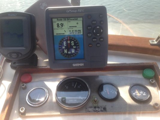
As I sit here waiting for our boat to be built, one of the big decisions I have to make involves electronics. Not just the brand that we will ultimately choose but also what equipment.
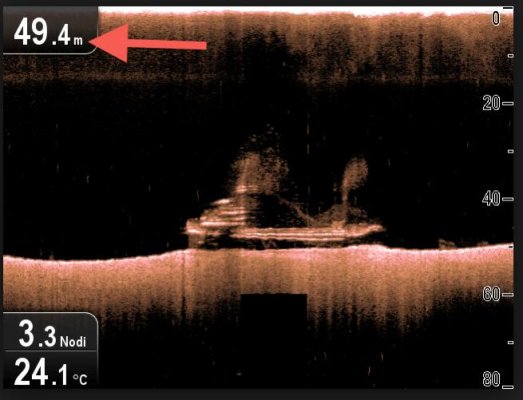
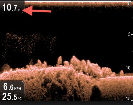
Now I'm trying to decide if we should have a fish finder or some kind of side scan/ forward looking sonar on the list.
I suppose the fact that I have not fished since I was 16 years old should be mentioned. I do sometimes think that I might like to take up fishing but so far I haven't been interested enough to try. Part of the reason was that I really did not want to clean fish in our teak floored cockpit as we sailed. I suppose it will be different now on the tug...?
So, is a fish finder actually helpful on a trawler for anything other than fishing?
Do I simply continue on living without it in blissful ignorance?
Any thoughts?
Help?
Bruce
 
Very useful even on a non fishing trawler. It shows the type of bottom (soft mud, tall weeds, rock, etc), and also paints a picture of bottom contours. A quickly undulating bottom calls for caution in case it undulates up to near the surface.

However, we also have a second depth sounder that only gives a digital readout as a backup.


What he said.

But I don't think I'd bother with forward looking sonar unless you just have to have all the bells and whistles.

And side scan is really only handy for fishing or diving where you are scouting for schools of fish or stuff to fish or dive on.
 
Ok, so there is some benefit to having a fish finder.
Is CHIRP technolodgy worth having then? My understanding is that it offers better resolution... Is it that simple?
Thanks,
Bruce
 
I'll chime in supporting a fish finder for cruising as opposed to fishing. Being able to get a sens of the bottom contour and makeup is very useful, I think.

I don't think I'd spend any more $$ to get chirp, at least not for cruising. If you were seriously into fishing, then maybe. But a good, regular fish finder will do wonders.

I've got a little Furuno FCV627, now replaced by the nearly identical FCV628. It was $600 very well spent, I think, and doesn't lock you into any brand MFD which I really like.
 
Ok, so there is some benefit to having a fish finder.
Is CHIRP technolodgy worth having then? My understanding is that it offers better resolution... Is it that simple?
Thanks,
Bruce

For basic bottom reading you don't need CHIRP.

But if there is little difference in the price between a CHITP transducer and a standard one for the unit you're getting I'd get the CHIRP.
 
This is an image from the excellent Blog of Airship to Alaska
It shows the detail that can be produced by a spread spectrum fishfinder... What you are seeing are logs on the bottom of an anchorage... CHirp ain't just for fishing
 

Attachments

  • Chirp.jpg
    Chirp.jpg
    141.4 KB · Views: 100
I'd love to see some of these in action! My intent was to look for both Furuno and Garmin at both the Newport boat show and or at the Annapolis Powerboat show. I just saw that Furuno will not be at either venue...
Bummer!
Well, I will call them and see if they have a good dealer locally.
Thanks for the input!
Bruce
 
What he said.

But I don't think I'd bother with forward looking sonar unless you just have to have all the bells and whistles.

And side scan is really only handy for fishing or diving where you are scouting for schools of fish or stuff to fish or dive on.

I'd have to disagree regarding the sidescan. We don't have it on our current boat but have previously and found it very handy for lots of things not least of which was checking an anchorage for obstructions prior to dropping the pick. Do one 360 turn with the sidescan on and you can see any obstructions in a fairly large area.
 
I'd have to disagree regarding the sidescan. We don't have it on our current boat but have previously and found it very handy for lots of things not least of which was checking an anchorage for obstructions prior to dropping the pick. Do one 360 turn with the sidescan on and you can see any obstructions in a fairly large area.

Good point.
 
Last edited:
This is an image from the excellent Blog of Airship to Alaska
It shows the detail that can be produced by a spread spectrum fishfinder... What you are seeing are logs on the bottom of an anchorage... CHirp ain't just for fishing

Getting a detailed image like that is worth it. I was thinking the OP was talking about a basic fish finder to use to see the depth of the water. Spending the money so you can get a detailed picture of the bottom is well worth it.


Since I'm too dumb to post pictures, I'll post a link.

http://salestores.com/stores/images/images_747/4068501.jpg

Those I feel are useless.
 
Last edited:
A standard color fish finder from Furuno or Garmin No side scan or forward scan or chirp is needed. Better if it also is GPS combo as a backup to the main chart plotter. The smaller display draws less current to be used as an anchor watch.
 
Well the best quality/feature fish finder you like will be more than adequate.
That said I installed the $119 Humminbird that the previous owner had in the boat when I bought it. It was still in the package actually.
Nice and small it fits on the upper helm where I run the boat 100% of the time.
I have been thousands of miles and have never (knock on teak) hit bottom.I have grown to trust it absolutely.

So....cheap or expensive they all work!
 

Attachments

  • IMG_0638.jpg
    IMG_0638.jpg
    102.2 KB · Views: 58
My understanding is that the so-called structure scan side sounded are only good up to maybe 100' then they lose it. Maybe some who has one can confirm. I tried one once and couldn't get it to work at all so replaced it with a Furuno which worked perfectly. Anyway, if you want depth and contour readings below 100', forget about structure scan.
 
Got a "fish finder" based on the boat-builder's (who has extensively sailed here) recommendation to provide a substantial display since shallow waters are so common here. Tiny digits aren't enough. And I'm not a fisherman!
 
I like mine a lot and mine is over 10 years old. It gives a running account of the depth, rugged or smooth, getting deeper or shallower and at what rate is the depth changing. I use the fish finder most when scoping out an anchorage. Going around in decending radius circles. Soon I know where all the shallow spots are, where the rocks are or logs ect. I also have a $700 Raymarine digital sounder but I was supprised to find how useful the silly little $100 fish finder would be.
 
I'll throw in my vote for the "useful even if you don't fish" view. There are great and expert discussions on The Hull Truth marine electronic forum by serious fishermen on the pros and cons of the various technologies.

I also cast a strong vote for having a second freestanding depth gauge with it's transducer on the other side of the boat. The transducer is the very critical piece of the system.
 
My understanding is that the so-called structure scan side sounded are only good up to maybe 100' then they lose it. Maybe some who has one can confirm. I tried one once and couldn't get it to work at all so replaced it with a Furuno which worked perfectly. Anyway, if you want depth and contour readings below 100', forget about structure scan.

We have a Simrad Structurescan on Blue Sky; not sure what version but it was installed new in 2013.

On the high definition setting (800 kHz) it will read to about 150` while on the lower definition setting (455 kHz) it will read to about 350`.

When the thing is working it produces an incredible view of the bottom. It has the side scan which I never use, which is a personal preference. The downscan is far more understandable.

However, the system is very flakey and so cannot be relied on for much. It is okay for entertainment (looking at wrecks etc.) but even at that it usually craps out just when I`ve got some interested visitors eagerly anticipating a view of something on the bottom.
 
We have a Simrad Structurescan on Blue Sky; not sure what version but it was installed new in 2013.


On the high definition setting (800 kHz) it will read to about 150` while on the lower definition setting (455 kHz) it will read to about 350`.


When the thing is working it produces an incredible view of the bottom. It has the side scan which I never use, which is a personal preference. The downscan is far more understandable.


However, the system is very flakey and so cannot be relied on for much. It is okay for entertainment (looking at wrecks etc.) but even at that it usually craps out just when I`ve got some interested visitors eagerly anticipating a view of something on the bottom.


"Entertaining" seems to be the operative word.
 
My understanding is that the so-called structure scan side sounded are only good up to maybe 100' then they lose it. Maybe some who has one can confirm. I tried one once and couldn't get it to work at all so replaced it with a Furuno which worked perfectly. Anyway, if you want depth and contour readings below 100', forget about structure scan.

I have Humminbird Side Imaging or what is generically called side scan on my center console. It can work in >100 ft depths with a big BUT. Boat speed over 6 mph severely degrades performance. Yes you can read depth at higher speeds but the unit is barely functioning as a depthfinder at that point.
Limitations come from a typical trawler in the way of installations. The vast majority of boat installations use a transom mount transducer. Some manufacturers now have through hull bronze transducers (one for each hull side) needed for inboard boats. The first ones were ordinary plastic! The side scan transom mount transducer must be mounted absolutely level. If its not mounted at the bottom (or very close) of the Vee, when on plane, there becomes an air gap between the TD and the side opposite the TD and that side will read poorly. Rudders, Trim tabs, and keels also interfere with the side imaging.
There is a significant learning curve to interpret the SS display.
In the 2 full seasons of owning Irish Lady, not once have I thought that it would have better to have my HB SI on board instead of simply reading Active Captain anchorage reports. Yes it will show the difference between smooth sand and jetty rocks on the bottom, but not discarded tow cables, ropes, or flat snags. You would have a hard time finding your lost anchor unless it was huge.
In summary, unless you plan to slowly search for underwater structure for fishing or diving, side scan is 99% waste of time and money for a trawler yacht.
 
Another vote for graphic depth display vs digital.
If you are installing Chart Plotter / GPS you won't need a separate fish finder just a compatible transducer & processor box that provides graphical depth...
You will have to decide if speed (in add'n to GPS) & water temp are important as they are different Xducer options

You can then customize screen displays w/ other info or full depth display to use when approaching anchorages etc.
 
You will have to decide if speed (in add'n to GPS) & water temp are important as they are different Xducer options.

Bacchus makes several good points. As for speed, I've never used a paddlewheel speed sensor that worked for more than a week or two before getting fouled. And even before they're fouled, I haven't found them terribly accurate.

Much as I'd like to know STW, and compare that to SOG to derive the set and drift of the current, I've never been able to get to that level of accuracy.

For me, the speed sensor isn't worth paying extra for.
 
As for speed, I've never used a paddlewheel speed sensor that worked for more than a week or two before getting fouled. And even before they're fouled, I haven't found them terribly accurate.

For me, the speed sensor isn't worth paying extra for.

I've had a paddle wheel that worked OK in fresh water - but did jam occasionally - a quick reverse cleared it most times
Calibration was OK at low OR high speed but would not be accurate for both

Bottom line I agree and went w/ depth and Temp but skipped the speed option when replacing mine a year ago
 
Just numbers wont work for me. In shallow or stirred up water the digital only displays may quit while the scanning display usually shows some info on bottom trend even if the return is not strong enough to display numbers.
 
I suppose the fact that I have not fished since I was 16 years old should be mentioned. I do sometimes think that I might like to take up fishing but so far I haven't been interested enough to try.
I know exactly what you are wrestling with. I don't fish as much as I used to but searching for wrecks is a neat past time! Raymarine's Chirp (Down vision Sonar) will do both. Mine is said to work as deep as 600 ft but I find that 300 feet is more accurate.

The first photo (Taken from the Web) shows good definition at 150 feet.
The second photo (also from the Web) at about 30 ft.
IMO, fishing at 150 or less is where the Chirp performs the best. (In fact i would say it's incredible!)
 

Attachments

  • 150ft.jpg
    150ft.jpg
    41.4 KB · Views: 52
  • 30ft.jpg
    30ft.jpg
    43.7 KB · Views: 44
Last edited by a moderator:
I suppose the fact that I have not fished since I was 16 years old should be mentioned. I do sometimes think that I might like to take up fishing but so far I haven't been interested enough to try.

I know exactly what you are wrestling with. I don't fish as much as I used to but searching for wrecks is a neat past time! Raymarine's Chirp (Down vision Sonar) will do both. Mine is said to work as deep as 600 ft but I find that 300 feet is more accurate.

The first photo (Taken from the Web) shows good definition at 150 feet.
The second photo (also from the Web) at about 30 ft.
IMO, fishing at 150 or less is where the Chirp performs the best. (In fact i would say it's incredible!)

So,
I can see that there is amazing detail in these pictures but as I look, I can't figure out what it is I'm looking at in that 150' shot.
It kind of appears to look like a sunken trawler or something...I've just been looking at videos on YouTube that explain the use of basic fish finders. I have much to learn apparently.

I am leaning toward the CHIRP system. Mostly due to the fact that it appears to be so much better at showing detail and now I'm simply curious about what's down there!

Thanks for the pictures,
Bruce
 
Last edited by a moderator:
I can see that there is amazing detail in these pictures but as I look, I can't figure out what it is I'm looking at in that 150' shot.
It kind of appears to look like a sunken trawler or something...


Codger, looks to me like the 49m pic was taken by a side-scanning or forward-scanning unit? I don't know if the down-vision units can create what looks like a lateral view?

-Chris
 
Codger, looks to me like the 49m pic was taken by a side-scanning or forward-scanning unit? I don't know if the down-vision units can create what looks like a lateral view?
That's a damn good question! I hadn't thought of that! The other picture, though, is typically what I'm seeing. I plan to cruise over some wreck symbols on my plotter and see what i can pick up.
 
Part of my work at the salt mine involves underwater search and recovery, usually stuff people try and dispose of, but occasionally people themselves. We use a high end sidescan sonar that cost nearly as much as my trawler. I think part of the issue is that the manufacturers of consumer equipment publish demos that are hand pick screen frames that are unrealistic in normal operation.

There's an art to sonar interpretation as opposed to just "sonar viewing." If you are expecting regular photos of the sea floor with consumer sidescan, you are going to be disappointed. I put the Garmin sidescan transducers in the trawler, but I've only been on one trip since (gotta pay the bills.). I've included a pair of screen shots from that trip.

I was pleasantly surprised at the performance of the Garmin sidescan. Given the limitations from purely a physics standpoint, they do well for what they are.

If you look close you can see the halocline in both standard and structure view.
ImageUploadedByTrawler Forum1473437910.148642.jpg

This shot is when I ran over a raised rock ridge. A decent return about 300' out from the boat, considering the transducers are at the surface and not a towed fish.
ImageUploadedByTrawler Forum1473437933.870161.jpg

If I ever manage to get two days off in a row I'm planning on heading out to the islands to play with my new toy. Lobster season is rapidly approaching...
 

Latest posts

Back
Top Bottom