Anyone prepping along the Florida and Gulf coast??

The friendliest place on the web for anyone who enjoys boating.
If you have answers, please help by responding to the unanswered posts.
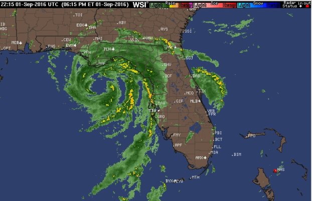
The thing has stopped (2mph to the north). Track over northern Florida has now been moved more northerly. Hopefully the mid-day update has it even further north.

They said it would probably turn into a named storm last night. It did not. It is still unformed.

It is a named storm now (Hermine). And that being almost stationary is kind of scary, given how warm those waters in the Gulf are. Still headed my way too, doggonit!
 
Went down to fishing camp in Cocodrie yesterday, raised the Whaler Montauk way up on the hoist. I hope I don't have to go back to trailer it back home/high ground
 
. . . and from the 5 PM report from the National Hurricane Center:

" The official intensity
forecast has been nudged upward a bit, and there is a distinct
possibility that Hermine could become a hurricane before landfall
."

And STILL headed toward me! Oh well. I am with the ones who believe that the marina is the best place for the boat. Up the St. Marks River, good tall pilings, and well secured with multiple lines.
 
Last edited:
Hermine current wind forecasts are:

Currently 45 mph.
Midday tomorrow 60 mph.
Tomorrow night around midnight, landfall, 70 mph.
Friday midday, Georgia 60 mph. Note: Inland, GA.
Continuing up inland to noon Saturday in NC and still 60 mph.

The concensus has it staying inland once it hits land, although some models still have it crossing to the east coast of GA.

Remaining tropical storm, but not a hurricane, although 70 mph is within 4 mph of a Category 1 so that's definitely possible.
 
Good luck to you JWnall, and any others in the storm's track wherever that turns out to be.
 
What Steve said. Been there and will, undoubtably, be there again.

In a few decades I've watched storm forecasting on the Gulf, I've become morbidly fascinated by how the weather guessers fail to account for the near inevitable decay of the initially predicted track to the left. More specifically, storm enters on westward track south of Florida, passes Florida and is expected to turn north. It eventually does and then, whatever the predicted track was, the cone moves left.

A day or so, ago, I was listening to the eye passing over Tampa, now it's the Big Bend. I can cite a bunch of similar track changes over 20-30 years. Not necessarily woofing on the met guys, but this storm behavior seemed pretty typical.
 
Man did we take a bunch of rain today....hard as hell and didn't let up till maybe 8 PM. Tim, I think you also got nearly 10 inches today up your way. Heck, I had to tarp part of my townhouse roof to stop ceiling damage from leaking A/C ducts. No real wind, but I sure hope we don't get this much rain tomorrow. Tornado activity predicted for this area and going NE across state tomorrow. Boat OK though. Wettest pre-storm approach I ever saw here in Florida or the Caribbean.
 
Larry, I live in Land O Lakes about 15 miles north of Tampa and we've had light rain all day Wednesday and no wind. No flooding here. Woke up this morning and no rain and no wind -- yet.

I'm going down to the boat this morning, just to check things out. I heard I-175 northbound lanes were partially flooded yesterday.

I'm in Dunedin...we got quite a bit of heavy rain yesterday, with bouts of wind mixed in. This isn't the storm tho...just precursor.

Actually dry this morning, but don't think that will last long.
 
Thanks guys...now it looks like it is going to park off NJ for a couple days...:eek:

Do me a favor? Pull as much out of him down there as you can.....:thumb:

Silly me, I was more worried about the organized storm off North Carolina a few days ago.....:facepalm:
 
Well. We are dead center of the cone, 6 miles inland, across the street from the Wakulla River. Latest forecasts are saying a cat 1 at landfall, though some; likely the sensationalists, click baiters and wish casters, are calling for a cat 2.

The boat, thankfully, is down in Stuart, safe and sound. I'm expecting some pretty significant surge as the coast here is so shallow so far off shore.

We got about 8 feet of surge in Dennis back in 2005. I paddled my Kayak 365 degrees around my house, but the water didn't quite make it in as we sit on a 7 foot high stem wall. My old boat (which now belongs to Jwnall) was anchored up the Ochlocknee River, drug three anchors, snapped a line tied to a tree and went ashore. Caused about $50,000 worth of damage.

I've got gas for the generator, plenty of food and water. We will move the cars to high ground tonight. My biggest worry is a tree falling on the house as we are in a heavily wooded area.

Have not been told to evacuate yet, hoping for the best.
 
Well. We are dead center of the cone, 6 miles inland, across the street from the Wakulla River.

Have not been told to evacuate yet, hoping for the best.

Keeping my fingers crossed for you, Doug. Glad to hear that the boat is in Stuart. One less thing to worry about.

I'm going to run down to St. Marks this morning to check all the lines, and arrange them a bit differently to account for storm surge. Other that, and stocking up on some gas for the generator and some bottled water, not much that I can do to prepare. It will be what it will be.
 
I hate Hurricanes! We keep our boat in a great little marina in Narragansett Bay. Floating docks with huge tall pilings and great protection. Whenever a storm of any magnitude approaches we do everything we can to prepare for it.
Canvass, sails, dinghy, bbq all come off of the boat or out of the water. We double up on lines, add chafe protection as necessary and then we do a check of neighboring boats!
Some of the things we have found on other peoples boats are amazing! I no longer stand by, I do whatever I can to secure sails, add lines or whatever is necessary to protect our boat from her neighbors.
Bruce

Yes, it's truly sad when you more fear damage from the incompetent neighbor's boat, than the storm itself. Know the feeling well.

Ted
 
Your main worry in St. Marks, John is going to be the surge. Dennis pushed a TON of water up into the river. Riverside restaurant's deck was 4 feet under. I'm not sure how tall the pilings are at your slip, hopefully really tall. There is a good chance that it will float the boat over the top of the pilings.

You may want to consider pulling the boat a little way out of the slip, tie the stern off of the outside pilings and set as many big anchors off of the bow as you can. That would allow for more flexibility. I don't think wind will be the biggest issue at Sheilds, its pretty sheltered.
 
Yes, it's truly sad when you more fear damage from the incompetent neighbor's boat, than the storm itself. Know the feeling well.

Ted

I am truly amazed at the number of owners that don't check on their boats DURING storms and heavy winds.
Last year we had 4 boats in our small marina that beat themselves up on the concrete dock because the owners failed to check their now misadjusted dock lines.
 
I am truly amazed at the number of owners that don't check on their boats DURING storms and heavy winds.
Last year we had 4 boats in our small marina that beat themselves up on the concrete dock because the owners failed to check their now misadjusted dock lines.
That is possibly why boat insurance has been steadily going up according to a senior BOATUS disaster coordinator I spoke with.

Seems like the losses associated with so many high priced boats these days, coupled with people who never even call marinas when storms are for cast (let alone hurricanes)....what could go wrong with that formula?

I have had to search for boats and jet skis and return them home for people who forgot to raise their lifts enough....let alone actually tie the boat off in any way.

Most think that insurance is more important than responsibility and knowledge. Plus where I am, probably 75 percent of the boats are owned by out of state weekenders and they think that taking off from other things is not worth coming down to check their boat.

I have had people call me up to move their boats in November in the snow because they "forgot" about their $300,000 dollars worth of boat and skis.

So no suprised for me when people don't lift a finger.
 
From the 1200 hour CDT NOAA Public Advisory

The water could reach the following heights above ground if the
peak surge occurs at the time of high tide...

Destin to Indian Pass...1 to 3 feet
Indian Pass to Ochlockonee River...4 to 7 feet
Ochlockonee River to Keaton Beach...5 to 8 feet
Keaton Beach to Chassahowitzka...4 to 7 feet
Chassahowitzka to Longboat Key...including Tampa Bay...2 to 4 feet
Longboat Key to Bonita Beach...1 to 3 feet
Florida-Georgia line to Cape Fear...1 to 3 feet
 
2 PM tide here in Longboat Key is 3 ft. over normal. More rain and wind started about an hour ago with steady 20 and 45 gusts, now slacked off again but endless number of bands on the way.
 
Someone asked how people are getting their hurricane information...
As a decidedly "non expert" weather fan, I like to use an app called Hurricane HD on my iPad to track storms. I love the way it gives a quick graphic that is easy to understand, including historical data and projections. Then there are all of the quick links to Satellite images, radar images, Bulletins and forecast models.
There is enough data here to absorb whatever time you want to spend and it is organized on a storm by storm basis on a big world map.
Bruce
 
National Hurricane Center
Just upgraded to official hurricane status.
Close your hatches !
 
I feel sorry for you guys in the bend area....
Carrabelle, Panacea around to St. Marks doesn't look real good. Wish I could help.

JWnall, Hope the lines at your marina hold well, and thats probably your best bet. When secured properly a boat can take one heck of a pounding and surge. At home, we can't do quite as well, if we're low. Hope your home come thru ok, too. Best of luck.

Here in St. Pete, things aren't too bad, Tide about 2 ft high, lots of rain and a bit of wind, but very doable.

Hopefully, we will get thru this without anyone hurt and minimal damage.
 
JWnall, Hope the lines at your marina hold well, and thats probably your best bet. When secured properly a boat can take one heck of a pounding and surge. At home, we can't do quite as well, if we're low. Hope your home come thru ok, too. Best of luck.

Thanks for the good wishes. I went down to the marina this morning and prepared the lines for a high storm surge, so have done all that I can do on that. So far as the house, I am 40 miles inland (north of tallahassee), and on high ground, so unless we have a tornado the house will probably come through it fine (although we might lose power).
 
I was down in st marks an hour ago helping a neighbor pull his pontoon boat out of the water. The river is running backwards, tide was raging upstream and the docks at st marks yacht club are underwater. Main road in st marks is about calf deep.

John, your boat is ok, rubbing on the pilings on the stub side. Finger pier is about knee deep. You've got about 6 feet of pilings still above the surface.
 
Last edited by a moderator:
I was down in st marks an hour ago helping a neighbor pull his pontoon boat out of the water. The river is running backwards, tide was raging upstream and the docks at st marks yacht club are underwater. Main road in st marks is about calf deep.

John, your boat is ok, rubbing on the pickings on the stub side. Finger pier is about knee deep. You've got about 6 feet of pickings still above the surface.

Thanks for the report, Doug. Guess I went down there in the nick of time this morning! I was pretty sure that the pilings were high enough so that the boat would not float out of them. I hate that it is rubbing on the piling, though. I had a fender positioned there, but the boat must have shifted some in the slip.

Hopefully high tide will not coincide with the maximum surge!
 
Wow,

Hope you guys are ok.

We had a nasty feeder band go thru here a few hours ago and winds are gusting to 40. Lots of stuff flying around, and you guys have it a bunch worse and probably won't have this behind you til late tomorrow.

Again, best of luck and sound like you're well prepared.

I went out a third time and tied down more toys and things, and added a few straps to the boat.
 
Seas up to 27' forecast with 15-20' fairly widespread.

On the other coast, seas up to 15' forecast for Charleston. Then by Saturday all calm and docile again.
 

Attachments

  • hermine1.jpg
    hermine1.jpg
    108.8 KB · Views: 38
Last edited:

Latest posts

Back
Top Bottom