You are using an out of date browser. It may not display this or other websites correctly.
You should upgrade or use an alternative browser.
You should upgrade or use an alternative browser.
Anyone prepping along the Florida and Gulf coast??
- Thread starter ragin cajun
- Start date
The friendliest place on the web for anyone who enjoys boating.
If you have answers, please help by responding to the unanswered posts.
If you have answers, please help by responding to the unanswered posts.
Star0210
Guru
- Joined
- May 7, 2016
- Messages
- 906
- Location
- US
- Vessel Name
- Sea Star
- Vessel Make
- 2004 Cruisers Yachts 50SS
It's a race between the three systems out there as to who gets what naming rights...we're looking at hermine, Ian, and Julia.
Julia if the system way out there gets that name is gearing up to be a major superstorm.
Hope the weather gods line things up so it stay a fish.
Julia if the system way out there gets that name is gearing up to be a major superstorm.
Hope the weather gods line things up so it stay a fish.
Now the nhc is saying there is a high probability for development of 99.
The little invest that just won't die.
Yes, but let's be careful that we, unlike the television teases, get exactly what they're saying. They're saying now that there's a 60% probability within 48 hours and 80% within 5 days of Disturbance 1 becoming a tropical depression. Still a long way from being a hurricane.
And meanwhile a 10% probability of Disturbance 2 which is carrying rainfall to Texas and Louisiana becoming a tropical depression.
Meanwhile Tropical Depression 8 is Bermuda and then NC bound and is expected to become a Tropical Storm.
When they say development into a tropical cyclone, people assume that means a hurricane and it doesn't. A tropical depression is a cyclone.
More rain for Louisiana is the scary part of all this.
Last edited:
McGillicuddy
Guru
- Joined
- Dec 4, 2015
- Messages
- 754
- Location
- USA
- Vessel Name
- Scot Free
- Vessel Make
- Cheoy Lee 53' Efficient
When the great flood comes, I will be on the arc. Or my version of it.
Sent from my iPad using Trawler Forum
Sent from my iPad using Trawler Forum
Star0210
Guru
- Joined
- May 7, 2016
- Messages
- 906
- Location
- US
- Vessel Name
- Sea Star
- Vessel Make
- 2004 Cruisers Yachts 50SS
Yes, but let's be careful that we, unlike the television teases, get exactly what they're saying. They're saying now that there's a 60% probability within 48 hours and 80% within 5 days of Disturbance 1 becoming a tropical depression. Still a long way from being a hurricane.
And meanwhile a 10% probability of Disturbance 2 which is carrying rainfall to Texas and Louisiana becoming a tropical depression.
Meanwhile Tropical Depression 8 is Bermuda and then NC bound and is expected to become a Tropical Storm.
When they say development into a tropical cyclone, people assume that means a hurricane and it doesn't. A tropical depression is a cyclone.
More rain for Louisiana is the scary part of all this.
I personally don't think it will ever strengthen above a tropical storm.
I personally don't think it will ever strengthen above a tropical storm.
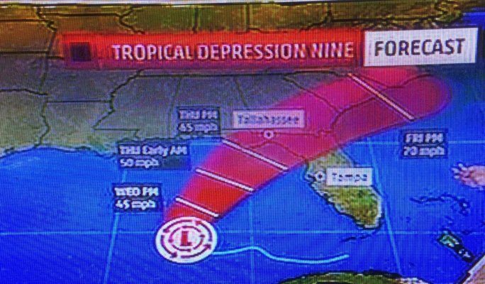
It won't ever reach tropical storm. Just tropical depression at most. Definitely not a hurricane. It's Tropical Depression 9. The projected paths seem to have mostly converged although a couple of exceptions. Most have it sort of in the middle of the gulf, then either the west coast of FL or Alabama, making landfall late Wednesday or Thursday. It could still have a lot of surge.
sbu22
Guru
- Joined
- Mar 16, 2011
- Messages
- 1,253
- Location
- US
- Vessel Name
- Panache
- Vessel Make
- Viking 43 Double Cabin '76
Yeah, Mark. HELL. In my time in paradise, I was part of the military assistance to the 71 Sylmar quake, was driving north on the Nimitz headed to Berkeley in 89 and durn near got thrown off the road with that one, and fought the Plymouth fire in 76 to protect my home, wife, and infant son (California drought before this one). It's all relative.
healhustler
Guru
- Joined
- Oct 2, 2009
- Messages
- 5,198
- Location
- USA
- Vessel Name
- Bucky
- Vessel Make
- Krogen Manatee 36 North Sea
caltexflanc
Guru
Here in eastern NC, people and marinas typically pull the trigger on moving/haul out until it becomes a named storm. I paid Jarrett Bay "protection money" to a get a guaranteed spot and paid the annual fee of $900ish (61' LOA Hatteras) gladly; they have a very well run program and blocked the boat correctly.
jwnall
Moderator Emeritus
Just saw the Tuesday 5 PM update, and the curve has improved for our area in SW FL Gulf Coast. Looks like the Big Bend is going to get most of it. Still will be plenty of rain and maybe some Tornadoes, but not too bad south if Tampa.
Yeah, looks like we're going to get most of it here (Tallahassee area) insofar as the coming ashore bit. But because of the counter-clockwise rotation, the surges will still be over there on the West coast of the Peninsula (Tampa and points north). If I had to make a guess, I would guess that it will reach tropical storm strength. But no more than that. Maybe. I hope.
")
Here in eastern NC, people and marinas typically pull the trigger on moving/haul out until it becomes a named storm. I paid Jarrett Bay "protection money" to a get a guaranteed spot and paid the annual fee of $900ish (61' LOA Hatteras) gladly; they have a very well run program and blocked the boat correctly.
Jarrett Bay has, in my opinion, the best run program in the country. They make good money on the fee most years but then comes a bad year and they have to do an amazing job with rough days and long hours.
Yeah, looks like we're going to get most of it here (Tallahassee area) insofar as the coming ashore bit. But because of the counter-clockwise rotation, the surges will still be over there on the West coast of the Peninsula (Tampa and points north). If I had to make a guess, I would guess that it will reach tropical storm strength. But no more than that. Maybe. I hope.
Nine is just barely a tropical depression now and projected to be on the lower end of a tropical storm. I haven't seen a surge forecast.
Looks like eight saw NC and got scared and just took off out to see and to the Northeast.
Deano
Senior Member
Nine is still tracking more west than north. I think that bodes well for us down in St. Pete.
It still looks disorganised on NOAAs satellite imagery. Subject to change. Kind of like my investment portfolio.
It still looks disorganised on NOAAs satellite imagery. Subject to change. Kind of like my investment portfolio.
timjet
Guru
- Joined
- Apr 9, 2009
- Messages
- 1,920
I just got an e-mail from my marina (Harborage marina downtown St. Pete). They are expecting 4 ft surge tides. They said they are pulling the ramps from the concrete bulkheads (J dock only where my boat is) to the floating docks by noon on Wednesday. I'm side tied to the floating dock with bow, stern and 2 spring lines. Debating on weather I should go down early tomorrow and pull all the canvas off and add additional lines. Probably won't.
mbevins
Guru
I just got an e-mail from my marina (Harborage marina downtown St. Pete). They are expecting 4 ft surge tides. They said they are pulling the ramps from the concrete bulkheads (J dock only where my boat is) to the floating docks by noon on Wednesday. I'm side tied to the floating dock with bow, stern and 2 spring lines. Debating on weather I should go down early tomorrow and pull all the canvas off and add additional lines. Probably won't.
I thought winds were only to 25-30 knts max. So you should be good for canvas.
timjet
Guru
- Joined
- Apr 9, 2009
- Messages
- 1,920
Yes, that's what I'm thinking.I thought winds were only to 25-30 knts max. So you should be good for canvas.
healhustler
Guru
- Joined
- Oct 2, 2009
- Messages
- 5,198
- Location
- USA
- Vessel Name
- Bucky
- Vessel Make
- Krogen Manatee 36 North Sea
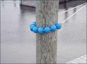
I've got a set of Tide Minders and new lines in my garage that I got at a Yard Sale in Key Biscayne a few years ago...never used them. Maybe I should figure a surge coming into Sarasota Bay and put them on, but I think I'll give it another 12 hours.....lazy. Some of the storms coming by in the meantime are producing some rough conditions and talk about tornadoes.
Attachments
jwnall
Moderator Emeritus
I've got a set of Tide Minders and new lines in my garage that I got at a Yard Sale in Key Biscayne a few years ago...never used them.
Had not heard of those before, so of course had to Google (how that became a verb I am not sure, but it has!) them. Neat idea, and some good reviews. On Amazon, too.
jwnall
Moderator Emeritus
Nine is just barely a tropical depression now and projected to be on the lower end of a tropical storm. I haven't seen a surge forecast.
We now have a hurricane watch posted for the coastal area in this part of Florida. Not sure I know why, but it is there. Just CYA I guess.
menzies
Guru
You know what?
60K dry weight displacement boat, probably nearer 70K currently loaded.
If it is designed to handle same in open waters then...
What the hey, off down the ICW to Palm Coast we go.
60K dry weight displacement boat, probably nearer 70K currently loaded.
If it is designed to handle same in open waters then...
What the hey, off down the ICW to Palm Coast we go.
HopCar
Guru
- Joined
- Aug 20, 2011
- Messages
- 5,308
- Vessel Name
- Possum
- Vessel Make
- Ellis 28
The Tide Minders are actually a new application of a piece of very old nautical technology.
The traditional name for them is Parrel Beads. They were used on gaff rigged sail boats as part of the rigging that held the gaff to the mast. Traditionally they were made of wood, lignum vitae if possible.
I think Ronstan and Schaffer make them now out of plastic.
Have you guys noticed that my head is just full of useless information?
timjet
Guru
- Joined
- Apr 9, 2009
- Messages
- 1,920
It looks like max gusts today for Tampa Bay is 28 kts with a tide height of 3.3 ft.
Thursday: 33 kts and tide height 3.3 ft.
Friday: 38 kts and tide height 3.3 ft.
Hurricane watch and tropical storm warnings were issued for the big bend area of FL just north of Tampa Bay.
Thursday: 33 kts and tide height 3.3 ft.
Friday: 38 kts and tide height 3.3 ft.
Hurricane watch and tropical storm warnings were issued for the big bend area of FL just north of Tampa Bay.
Lobstah
Senior Member
- Joined
- Jul 10, 2011
- Messages
- 242
- Location
- USA
- Vessel Name
- T/T Whistful
- Vessel Make
- Boat US 12' Inflatable
You know what?
60K dry weight displacement boat, probably nearer 70K currently loaded.
If it is designed to handle same in open waters then...
What the hey, off down the ICW to Palm Coast we go.
I was looking at your boat avatar in your previous post, and thought the same thing
Safe travels
psneeld
Guru
For newbies.......
Just remember that while 30 knots of wind won't usually blow canvas off.....
30 knots for a good duration will flog the crap out of it and can damage it if a corner works loose or a zipper fails.. flogging can really destroy gel coat if it pulls a fastener and it is at the end of the flogging canvas.
Good condition canvas, seams and secure fasteners will usually be good...just in case they are not....
Click on NOAA's Potential Storm Surge Flooding Map (Inundation), 5 am this morning. It looks like 6' plus in some areas.
Tropical Depression NINE
Tropical Depression NINE
mbevins
Guru
It looks like max gusts today for Tampa Bay is 28 kts with a tide height of 3.3 ft.
Thursday: 33 kts and tide height 3.3 ft.
Friday: 38 kts and tide height 3.3 ft.
Hurricane watch and tropical storm warnings were issued for the big bend area of FL just north of Tampa Bay.
38knts? What's the magic number that you're taking the canvas down? Up on the Great Lakes odds are we'll hit 40 maybe once a year for a day. And I get very attentive during that time.
timjet
Guru
- Joined
- Apr 9, 2009
- Messages
- 1,920
No magic number, but psneeld kinda hit the nail on the head.38knts? What's the magic number that you're taking the canvas down?
It's not so much the number but the duration.
menzies
Guru
The thing has stopped (2mph to the north). Track over northern Florida has now been moved more northerly. Hopefully the mid-day update has it even further north.
They said it would probably turn into a named storm last night. It did not. It is still unformed.
They said it would probably turn into a named storm last night. It did not. It is still unformed.
Similar threads
- Replies
- 10
- Views
- 2K
- Replies
- 17
- Views
- 2K