motion30
Guru
- Joined
- Jan 14, 2010
- Messages
- 1,181
I'm surprised nobody has said this yet. The most dangerous thing you can have for a trip on your boat is a schedule
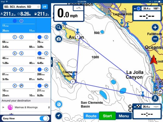
Can anyone tell me how I could figure out distances ( by water ). My problem is we are planning a trip in the early fall but only have a certain time to do it. I know there are a lot of things that can throw things off such as weather, break downs, etc. We're figuring on doing sixty miles a day + or - .So I'm looking at 20-25 days ( that's round trip ) but am trying to figure how far we might be able to get. I know there will be a lot of different opions about this but that's why I'm asking. Thanks in advance.
")
I'm surprised nobody has said this yet. The most dangerous thing you can have for a trip on your boat is a schedule
thank you...just never held long enough to get a window!
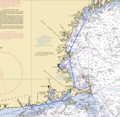
Drake: Mile Markers are on the GICWW. If I remember correctly Houston Ship Channel is close to MM350 W. They start at the Mississippi River and go east or west.
I have read it before but have yet to see where the tool is on Active Captain for measuring distances....any tips?
On the regular Active Captain website....or is this an app/chartplotter that supports Active Captain?
Wilpep I think you are using a navigation app. There are several navigation aps that have the Active Captain data. Garmin Blue Charts is one, and Coastal explore is another. But the navigation features are not part of Active Captain I use both Garmin and Coastal Explorer and have been an active captain supporter for many years. There is no navigation program so far as I know.
Well, perhaps I do not know what a hard click is, or something. I can see the AC content. I can open it and change it, but I caIn my computer the help tab merely explains what the cards are and what you can do with them. I do use their data on Coastal Explorer and Garmin BlueCharts. I'll ask Jeff and get back to you .
on my Dell laptop touchpad...it's a double tap and hold. In a second or so, a window for a route or measure opens up with a couple other things.
just tried it, left click and hold does work on my touch pad.On my Dell it's just holding the button. When I first looked at AC it took me quite a while to figure out how to get the menu to open. Every other program I know would use a right click. Once you find it though, no problem


Interesting question, Mark. Union slams "two watch system" studyIsn't it traditional that mariners have four-hour watches? It's difficult to be fully attentive for much longer. Six hours are pretty much my limit, but I prefer four.
...
Real captains and real drivers are regulated. You an me...not so much.
Will Active Captain lead us to that ideal world you live in?So, we must self-regulate. Knowing our personal limitations and paying attention to them is important since "Daddy" isn't there.
Isn't it traditional that mariners have four-hour watches? It's difficult to be fully attentive for much longer. Six hours are pretty much my limit, but I prefer four.
You will be just fine. Warmer and drier too.I may discover my limits this week.