Distance

The friendliest place on the web for anyone who enjoys boating.
If you have answers, please help by responding to the unanswered posts.

gonesailing13

Senior Member
Joined
Jul 2, 2013
Messages
148
Location
usa
Vessel Name
Graceful
Vessel Make
Marine Trader
Can anyone tell me how I could figure out distances ( by water ). My problem is we are planning a trip in the early fall but only have a certain time to do it. I know there are a lot of things that can throw things off such as weather, break downs, etc. We're figuring on doing sixty miles a day + or - .So I'm looking at 20-25 days ( that's round trip ) but am trying to figure how far we might be able to get. I know there will be a lot of different opions about this but that's why I'm asking. Thanks in advance.
 
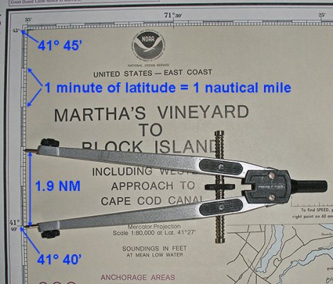
Water way charts have mile markers, Google earth has a distance measurer as a straight line or as a path as in measuring distance on a river. I hope this helps.
 

Attachments

  • chart-and-latitude-scale.jpg
    chart-and-latitude-scale.jpg
    148 KB · Views: 105
I think the OP is asking what a reasonable number of miles per day is to expect.....

If I'm right I have to answer the questions with more questions:

What kind of boat?
What is your cruising speed? Maximum speed and can you do that for a few hours without breaking the bank?
Where? Inner coastal? Lake Erie? Mississippi? Reason I ask is because of weather, currents, bridges fuel availability.....

I have done 125 to 150nm per 24 hours reliably (ONCE did a 200nm day). On the Ocean, in a sailboat, with a lot of wind or motoring hard, in the Gulfstream.... IOW busting butt around the clock. In the Inner Coastal with bridges and no night time movement (63' mast) I was lucky to do 75 on a loooong day.....
 
Last edited:
I read it as trying to figure distances.

In the PNW, there are some websites that will list distances between common ports. That is easy.

Hawgwash showed you the tried and true method. Works every time. Just figure out the distance for each leg and and them up.

Since I have Raymarine chart plotters with Navionics chart cards, I use Raymarine Voyage planner. Create a route and then it will give you the total distance for the route. BTW, I am not recommending the Raymarine Voyage Planner. I use it, but I don't love it.
 
I have to agree with others who have responded that your question that it is a little confusing? Are you asking about distance from point A to B in a certain geographical area or straight time in a day? If the second, you can roughly calculate 6 knots will get you about 6 miles in one hour. 60 miles equals 10 hours (been there and done that many times in one day).

John
 
Just a comment on your daily plan - at trawler speeds, that's approaching 10 hours a day -no stops, no refuelling, no shopping, no sight seeing - no nothing - for 20 to 25 days - that's not a holiday - that's an endurance test -a marathon.
 
I have to agree with others who have responded that your question that it is a little confusing? Are you asking about distance from point A to B in a certain geographical area or straight time in a day? If the second, you can roughly calculate 6 knots will get you about 6 miles in one hour. 60 miles equals 10 hours (been there and done that many times in one day).

John

Close but no cigar. 6 knots will take you 6 NAUTICAL miles in one hour.
 
On the Atlantic ICW, with a 7 knot trawler, heading south for the winter, we plan on daily runs of 50 nautical miles per day and we figure on traveling 5 days per week. That leaves time for improvising and exploring a bit, and even allows for bad weather, which is rather rare on the ICW, where except for the bigger sounds, most of the waters are quite protected. In interesting cruising areas we only figure on travelling 3 days per week. Northbound we tend to take a bit more time because the days are longer and we like to stop and explore.
 
Try "distances between ports intercoastal waterway", it's on the web.
 
The AICW and GICW have statute mile markers. That covers the coastal route from Portsmouth VA to Key West and from Carabelle FL to The Tex/Mex border. To the best of my knowlege those are the only two coastal routes with statute mile markers on NOAA charts.
 
�� I agree!

Codger's post here reminded me that many, many years ago, before he changed his name, Walt sent me a mapwheel like this.

SC00700.jpg


Scalex Map Wheel Digital Map Measure 00700 - Tiger Supplies

It was a very generous gift from a friend who was interested in the product, but didn't really need it. Several of us were discussing it on a TF thread and were debating its user friendliness and its usefulness in a digital world. The next thing you know, I've got a brand new one in my mailbox compliments of Walt/Seahorse/Codger2! He figured I could use it and, being a gadget-loving guy, I'd give it a test. He asked that I let him know how it was, but I think I forgot to follow through. Oh well...sorry Wally!

Anyways...I tried this thing and once you get used to its various scale settings, it's pretty good. Only thing is that I almost never use paper charts for real planning anymore. All my trips are planned digitally on my laptop or tablet. But I'm sure there are some out there who might find some regular use for this instrument, so I'm offering it free to the most deserving.

If you're out there boating on a budget and use paper charts for planning, this might be just the gadget for you. I guarantee that there are very few inches on that tiny, little wheel at the working end of the instrument.

If you're interested, send me a PM. Operators are standing by.
 
When I travel I generally "plan" on 6 hours of running x 6 knots (easy calcs) = 36 nautical miles.
Some days will be longer maybe 8 or more, some will be less depending on currents, locations, etc., but I've found the 6 hours plan seems to work for me without being a "job".
Leaves time for exploring at the anchorage, resupplying, repairs, etc.
 
but I've found the 6 hours plan seems to work for me without being a "job".

Valid point concerning "job". Here on the east coast you may develop what is sometimes referred to as the " ICW hunch". After a week of 8-10 hour days you find you develop a white knuckled grip of the wheel as your eyes dart ahead, to the chart plotter, ahead again, to the depth finder, ahead again, to the engine gauges and back to the chart plotter. Cruising is no longer fun. Put in a long day from time to time when you have to, but don't let it become a job.
 
Remember your 6K boat will do about 7 lubber miles per hour , what the ICW is measured in.

Weather will play a large role , so the best is to guesstimate a distance , say 60 miles then look at the chart to see where that distance gets you.

Locate a Marina or anchorage as near as you can and use that as a target.

Bridges may add big time , as well as bogus Manatee zones and endless no wake zones.

So look 2 or 3 hours shy , say at 40 milers and see if you can find an O nite spot.

Many parts of the ICW connect inlets , so what you loose to current one portion of the day you may gain later.

Gas stops are best done at mid day, the dock is usually empty , and the hose monkey is not busy , so it goes quick if desired..

We prefer anchoring out , so stopping at 11am, doing a wash , walking to a grocery and taking on water as well as fuel can all be done in an hour , or an hour and a half.So most spots are happy to have you.
 
Last edited:
IMO the fastest way to assure your crew won't want to ever get on the boat again is to follow your plan. Slow down spend time in closer places. The closer place can be just as interesting and enjoyable as the farther places.
Spending a month without ever leaving the Chesapeake and it rivers is easy and would be a lot of fun.
Cruising is different than driving where you zoom past everything. pick places to stop whee you can walk to local towns. They are often interesting if you ask around.

The interesting thing about coastal towns is that since they grew up on the water they are what i call half towns with the old center right where you can dock for easy walking exploration.
 
Last edited:
Garmin's Blue Chart app has a simple distance measuring tool. We use it extensively for trip planning. It's not as precise as using mile markers (which we don't have on the Gulf coast ICW), but it is sufficient for planning.

Great app, BTW.
 
It's not as precise as using mile markers (which we don't have on the Gulf coast ICW), but it is sufficient for planning.

Great app, BTW.[/QUOTE]

My NOAA charts do show mile markers along the Gulf coast.
 
Just a note: The ICW and inside rivers and lakes are in statute miles and MPH , ocean outside is nautical miles and knots. We switch our instruments when changing areas.
 
I second Google Earth. Extremely accurate. Use it quite a bit while daydreaming at my desk. Of course it doesn't take into current and tides into consideration.
 
We plan 25-30 miles days. Pleanty of time to relax.
 
Back
Top Bottom