Chart inaccuracy

The friendliest place on the web for anyone who enjoys boating.
If you have answers, please help by responding to the unanswered posts.

koliver

Guru
Site Team
Joined
Nov 23, 2007
Messages
5,662
Location
BC, canada
Vessel Name
Retreat
Vessel Make
C&L 44
Yesterday, as I was heading through Gabriola passage, Eastbound, I encountered a 45' sailboat high on a reef. Another boater was on scene, with a 115 hp dinghy, as I approached in mine, with another 40 hp. We each took a halyard from his masthead and quickly had him heeled to 45 deg and he was able to power off safely.

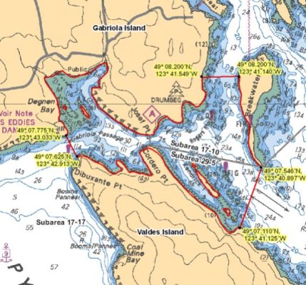
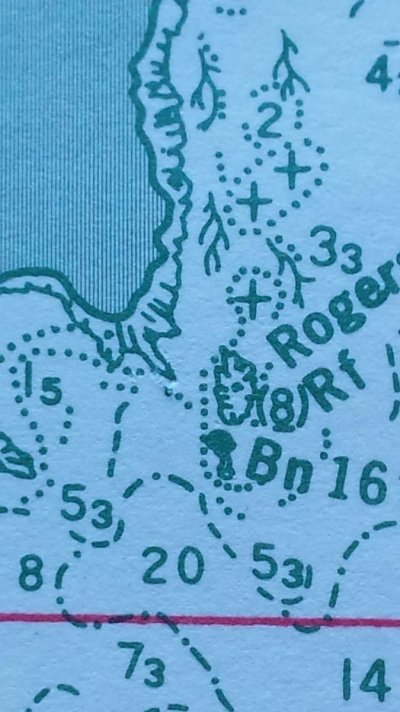
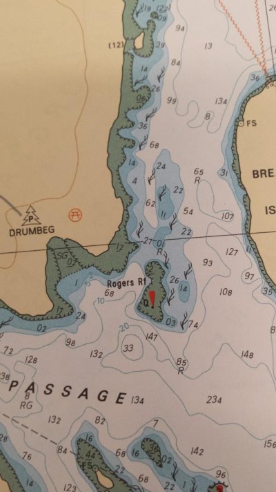
This morning I returned to the site and took careful note of the position, relying upon my track as recorded on my plotter from the day before. I have now checked the electronic charts that I have in my plotter, on my Phone and in my computer. and the paper charts in my Evergreen Atlas, CHS chart 3310 (Gulf Island Strip Charts). None show the reef accurately, so the fellow's claim that this reef wasn't on the chart has complete credibility. Where he was high out of the water, the charts all show the depth to be over 20 ft. The reef actually protrudes at least 100 ft further than the charts would have you believe.

Ordinarily, this small inaccuracy would cause no concern, but here was a very nice yacht, caught unaware and in imminent danger of serious damage, due only to the inaccuracy of the data that we have all come to rely on as being very accurate. This incident serves to heighten my own awareness of the fallibility of the Canadian Hydrographic Siurveys and the charting software produced by others from that original bad data. I hope this post will heighten the awareness of others.
 
Last edited:
Thanks, a Lon/Lat would help other boaters avoid this spot..
 
Keith

Where precisely is this anomaly in the passage? Was it a lower tide encounter?
 
This incident serves to heighten my own awareness of the fallibility of the Canadian Hydrographic Siurveys and the charting software produced by others from that original bad data. I hope this post will heighten the awareness of others.

Do you know how old the survey is? IIRC some marine surveys are 100 years old or more. Also, within the Ring of Fire, changes can be quite dramatic and fast.
 
Here in the northern GOM charts are useless after a hurricane. I've been fishing on chandelier island and entire islands disappeared after Katrina
 
Aren't low water depths on Canadian charts given at the "average low water level", not the lowest low tide of the year level? Was the tide lower than the average (a minus tide) at the time, making the reef "higher" than the boater thought?
 
Last edited:
47 07.925N 123 41.533W.
This is the dinghy channel behind the mark, used as a short cut between Silva Bay and Gabriola Passage. In a hundred or so passages through Gabriola, I have never used this channel with the big boat, but I use it frequently with the dinghy. I didn't expect the sailboat to be there and wasn't very surprised that he had gone aground, while attempting what I thought was a risky passage. When he claimed to have used that passage successfully many times before, I was initially sceptical.

The tide at the time was not low, this was only a short time after high tide, and when I went out later I could see the part of the reef that sailor had been on, now 4 ft out of the water.

I have no idea how old the survey is.

I have the Navionics udates on my phone, and they show exactly the same contours as my oldest CHS charts, so repeat the errors, and will do so until there is a new survey done.

This is solid rock, so weather events like Katrina would have no effect.
 
Canadian charts use a lowest low water datum and are more conservative than US charts that use an average low water. You will rarely see a 'minus' tide in Canada but frequently see them in the US because of the different measure.
 
Yup Keith, at 49.7.925 N I see where you mean. Sail boaters do enjoy the shortest lines.
 
47 07.925N 123 41.533W.
...
I have the Navionics udates on my phone, and they show exactly the same contours as my oldest CHS charts, so repeat the errors, and will do so until there is a new survey done.

koliver,

Do you have the Navionics Sonar Charts loaded? I recently paid $15 for them and the increased accuracy and detail is impressive.

These charts are 'crowd sourced' by data recorded as participating boaters with new chartplotters navigate the area. The data of the bottom soundings are stored and sent to Navionics where it is processed into updated charts. I'm finding holes and shoals in my home waters that I never knew existed.
 
The reef actually protrudes at least 100 ft further than the charts would have you believe.

Could this explain the discrepancy?

"Once you have your chart, the first step is to make sure that you have selected the right chart datum on your GPS/DGPS receiver. This information is shown in the Horizontal Datum note near the bottom of the chart's title note and looks like this: NAD 27 & NAD 83. Some receivers may show WGS 84 instead of NAD 83.If the Horizontal Datum Note says that the chart is on North American Datum 1983 (NAD 83), then select NAD 83 or WGS 84 on the GPS/DGPS receiver. Then you may plot positions directly on the chart. Alternatively, you could input positions scaled off the chart, inputting these to the receiver as "waypoints".

If it says the chart is on North American Datum 1927 (NAD 27), you have two choices:

You can select NAD 27 on the GPS/DGPS receiver and then either plot the positions on the chart or input the positions to the receiver. With this procedure, however, there is the possibility that, in some parts of Canada, you may end up introducing an additional positioning error of up to about 50 metres.

You can select NAD 83 or WGS 84 on the receiver and manually follow the instructions of adding or subtracting published constants to both the latitude and longitude before plotting on the chart. To input coordinates scaled off the chart, one needs to reverse the mathematical operation before inputting the value to the GPS/DGPS receiver.

All Canadian charts are being converted to NAD 83 as new charts or new editions are produced."

Nautical Charts - CCG - DGPS

Just trying to figure out why this problem exists in such a heavily traveled area...
 
That area is just loaded with reefs and rocks... I don't know if you mean the dingy passage leaving Silva Bay to the east or the south side of the reef that is clearly marked prior to Gabriola Pass... A skipper has to use common sense and a depth finder when navigating these waters... The Exploring series of books provides an excellent guide to safe routes and hazards in the area... As well marked as Shipyard Rock is I have seen a few boats that been stuck on it... For those that haven't been in the area, shipyard rock is in the north passage leaving Silva Bay. The last time I was there it was marked with a lighted buoy as well as clearly designated on all the charts..
 
Whereabouts on this chart segment?
 

Attachments

  • 13_Valdes Island__Gabriola Passage.jpg
    13_Valdes Island__Gabriola Passage.jpg
    76.9 KB · Views: 111
Here is what Active Captain says about the area:

Gabriola Pass is between the NW end of Valdes Island and Gabriola Island, connecting the NW end of Pylades Channel to the Strait of Georgia. This route to Georgia Strait is recommended only for those with local knowledge. The velocity of the current in the pass is 4.0 knots, setting E on the flood and W on the ebb. The current may attain a velocity of 8 knots.

Rogers Reef is a dangerous submerged reef at the eastern end of the passage between Gabriola and Breakwater Islands. It is marked with a beacon tower and quick flashing white light. Currents in the pass may set your vessel toward this reef. When transiting the east passage between Josef and Cardero Points, maintain a clearance bearing of 83 deg true (eastbound) or 263 deg true (westbound) from the marker pole (flashing red) on Breakwater Island and monitor possible northward set onto Rogers Reef.

The pass tends to collect moving debris which may impede navigation.

The outermost danger off Gabriola Pass, Thrasher Rock, a detached steep-to rock that dries, is 2.3 miles NE of the pass entrance. A light is on the rock. Shoreward of it are many rocks and reefs, including Gabriola Reefs; caution is essential.
 
Thanks, Keith. I've put a mark on my CM93 charts at that location. I always keep well to the Breakwater Island side of the Rogers Reef mark... the contours look nasty on the Drumbeg side as it is, but this will remind me not to be tempted!

rogersreef.PNG
 
The place is full of rocks, some folks have a really hard time with all the markers. Here's shipyard rock living up to it's name. This fellow went right between a green can buoy and a green day marker/light. I often wonder how they got in if they can't get out.....

Greenmarker.jpg

Also there's an isolated rock a long way off the Valdes beach to the east of Cordero Point, surprised a few people. Stay in the middle going through Gabriola Pass.
 
Last edited:
Could this explain the discrepancy?

"Once you have your chart, the first step is to make sure that you have selected the right chart datum on your GPS/DGPS receiver.


Murray, I don't think that's the problem in this case.

The CM93 chart I posted above is WGS84. To cross-check, the location of the Rogers Reef daymark on that chart is exactly at the coordinates https://www.notmar.gc.ca/publications/list-livre/pac/p2652-en.php says it should be.

But the chart contours don't give any indication that a drying reef extends to the location referenced by koliver.
 
Murray, Hawg,QB:

QB has it nailed.
On Hawg's chart segment, treat the "e" of the word "Roger's" as the end of the drying portion of the reef.
 
In the US there are regularly released notices to mariners and quite a few of them. New areas are shoaling in the ICW all the time. That's why many who use the ICW also look at cruisersnet.net and Waterwayguide.com. I don't know if there are similar notices in Canada or similar private sites reporting problems.
 
First, Keith, I don't question you or your navigational skills. At all!

I'm just really baffled by this one.
So many places on the coast I could understand but, how does that sucker, if accurately depicted by Keith, get a pass all these years?

Surely your readings can't be out by +/- 100 feet.

Even if it is a case of local knowledge, it should have been noted and corrections made long ago. I wonder why other sailboats had not "discovered" it. Unless this was the first 45' sailboat to venture into a "dinghy" passage. Still, it should be on the chart.

Interestingly enough, even though the Marine Atlas Volume 1 is strictly a reference guide, it shows an extending shoal different from CHS 3475.
Page 24 pictured.
 

Attachments

  • 20160703_134117.jpg
    20160703_134117.jpg
    102.9 KB · Views: 78
Murray, thanks for saving me from myself.
I typed and deleted a reply that, while not meant to be sarcastic, would probably have been taken as such.
 
Koliver...you said you used an Evergreen Atlas which used CHS chart 3310.

I checked the CHS site and chart 3310 has been replaced by chart 3313. Maybe the reef in question is on the current chart?

http://www.charts.gc.ca/charts-cartes/withdrawn-retires/index-eng.asp

Also, could this be a classic case where the fellow who went aground didn't "zoom in" on his electronic chart, and if he had zoomed in it would have shown more bottom detail?

Still trying to understand...
 
Koliver...you said you used an Evergreen Atlas which used CHS chart 3310.

I checked the CHS site and chart 3310 has been replaced by chart 3313. Maybe the reef in question is on the current chart.
Still trying to understand...
Nope 3313 doesn't show it either.
 

Attachments

  • KOliver.jpg
    KOliver.jpg
    86.9 KB · Views: 84
Last edited:
Weird...

So the lesson is, when in skinny water close to shore keep an eye on your depth sounder and watch the waters surface for indications of uncharted rocks in ones path.
 
Besides what I consider lack of situational awareness by the skipper meaning monitoring the sounder as well the chart plotter... I have noticed that some detail is missing from digital charts especially further north... For most purposes this lack of detail is not an issue... However fishing in tight to shore or going through narrow passages into anchorages it can cause a problem... My previous boat had a Westmar searchlight sonar we always used it when ever we in unfamiliar water... It was amazing the lack of detail of some charts... I suspect that when charts are digitized the algorithm tries to smooth some of the drastic bottom elevation changes that in these waters
 
Keep watch on the depth finder. My builder recommended a fish-finder display (followed) since I boat in shallow waters.
 
Back
Top Bottom