GPS Laptop Question

The friendliest place on the web for anyone who enjoys boating.
If you have answers, please help by responding to the unanswered posts.

GFC

Guru
Joined
Nov 14, 2012
Messages
4,406
Location
USA
I have a GPS on my upper helm and usually drive from there. I don't have one on the lower helm but have been thinking about using a laptop for that.

I have a couple of questions about setting up a laptop for that use:
1. What do I need to get a GPS input to the laptop? Can this be via wifi or does it plug into a USB connector?
2. What is a decent software to use with a Windows 10 laptop?

Anything else I need to know to set this up?

Thanks.
 
Hi Mike
I'm cruising the caribbean and have a garmin chartploter at great expense. In reality I bought the NV chart kits that come with the cgarts on CD rom with Nav lite software. I just use a $28 BU-353S4 hockey puck style GPS antenna. Tptal cost about $100. This gives more detailed charts andthe laptop keystrokes are far easier to use than the Garmin. Zooming for instance is the plus and minus buttons... Panninbg is the scroll etc. So easy to use. It also I believe accepts downloaded charts from NOAA. Although down here I use the paper charts as well ( lots of reefs , and knarly bits) I tend to mark no go area's on the paper. http://www.amazon.com/GlobalSat-BU-...=UTF8&qid=1462743644&sr=8-1&keywords=bu-353S4.
Amazon have the GPS antenna $29. .
Hope this is helpful
 
Last edited:
The simplest GPS solution is a BU 353 USB unit. They are about $30 on Amazon.


A very nice nav system is Coastal Explorer. Very professionally done and it has no reported problems with the above GPS. Not cheap at about $360 or $390 with the above GPS packaged.


A freeware solution is OpenCPN. I like its user interface very much, but some have problems with its GPs interface dropping out.


Also go to activecaptain.com and look at their recommendations for Windows nav products.


David
 
Mike,

We use a lap top with Nobletech Odasey on it and a gps puck. Great system.

Ken
 
Simplest is a GPS receiver that plugs into a USB port, <$40. This also provides complete redundancy in the event of a problem with current electronics.

Lots of choices in software. If you use Active Captain, go on their sight for a list of software providers that have Active Captain integrated.

Ted
 
I used a Bluetooth GPS myself for this purpose. I just left the GPS on the lower helm and could use laptop (and for that matter, stationary desktop in salon) anywhere on the boat.
 
Last edited:
I like a Garmin marine hand held GPS connected by USB cable. Fewer points of failure that blue tooth. Let me put a plug in for redundant redundancy.

1 – A hardware based system of your choice. Furuno, Garmin, Raymarine. Whatever looks good to you.

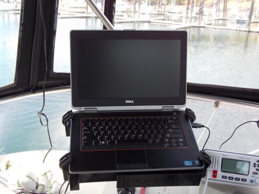
2 – A laptop based system. Running software of your choice. Taking position data from a GPS via USB. I say USB because the interface is a cord not relying on batteries or wifi signals as does Bluetooth.

3 – For the GPS I use a “real” GPS. The reason is with your routes and waypoints pre-loaded it provides the final fail safe redundancy.

4 – At least a minimal set of paper charts along with the tools and skills required.

Choose a GPS that comes with the ability to upload/download .GPX format. Same for the software. Best of all is if your hardware system can also easily upload waypoint & route data.

When planning a voyage I “draw” my routes and waypoints in the laptop's software. Save As .GPX to the laptop's HD. Upload to the GPS and hardware based plotter.

So, in the event of failure of the main hardware system or failure of the boat's electrical system when I loose my main system the laptop is ready to go. Depending upon the laptop I can count on 3+ hrs of built in battery time. Remember charting software eats batteries. 3 hrs will often be enough time to reach safe harbor, safe anchorage or fix the problem. If I'm further out from safe harbor than the laptop will run I drop down to the GPS. My current hand held GPS is good for up to 20 hrs on a set of AA alkaline batteries. I navigate to within an hour or two of the entrance where charting software really comes into it's own then I fire up the laptop and arrive in style.

A marine handheld GPS is a rugged device. It can take dousing from salt water spray and some drops to the deck. Not so a laptop.

I didn't mention tablets and smart phones for a couple of reasons. The first being they are no more rugged than a laptop. The second is a bit sneaky. A “real” GPS prioritizes accuracy over time to fix or when the signal is weak. Many tablets and smart phones prioritize time to fix over accuracy using cell tower locations to speed the process. But they don't tell you when they are using what. That works fine when using road navigation software, the system can almost always “snap to” the correct road. But when I'm making a narrow entrance with a following sea I want to know what I'm seeing is accurate.
 
Another alternative, if you have AIS, is to pull a line from that unit to your laptop. That way you have AIS and GPS on your lap top as well as plotter.
 
Or... I run an iPad with built in GPS at my lower helm with Garmin BlueChart. Works fine

Arch
 
Thanks a lot for all the replies and the help. I ordered one of those GPS pucks. The BU 353 has been discontinued and replaced at the same price with the BU 353S4 model.


I went to Active Captain to search out a software package for the charts and that led me to a new question: Do any of those companies produce charts for Canadian waters?


I didn't read thoroughly through each product description but they all appeared to make chart software for US waters but I didn't see any mention of BC waters.


I'll keep reading and looking. Thanks again for all of the information.


Two thumbs up to all of you!
 
Last edited:
Late to the game here. I used Coastal Explorer and found it excellent. I bought charts for BC and can't remember the exact price but think it was around $120-$150.

For a GPS I used a newly purchased AIS system. The puck is a good idea IMHO - I wouldn't trust a WiFi or Bluetooth connection for something as critical as my primary GPS.

Richard
 
We also use Coastal Explorer on a laptop. The Canadian charts are about $100 each for Raster and Vector.
 
A laptop with a BU 353 puck and Polar Navy. Less than $100 invested. Both raster and vector US charts are free downloads from NOAA.
 
I should be getting my GPS puck tomorrow and I'm looking forward to plugging it in and seeing how it works.


John, I like the idea of a cost below $100. I'll have to check out Polar Navy and the NOAA downloads. Thanks.


I'll decide on a software program in the new few weeks and then have lots of time to try it out before we do a long distance cruise.
 
The simplest GPS solution is a BU 353 USB unit. They are about $30 on Amazon.


A very nice nav system is Coastal Explorer. Very professionally done and it has no reported problems with the above GPS. Not cheap at about $360 or $390 with the above GPS packaged.


A freeware solution is OpenCPN. I like its user interface very much, but some have problems with its GPs interface dropping out.


Also go to activecaptain.com and look at their recommendations for Windows nav products.


David

Mike,

This similar to what I did. I bought a refurbished laptop from Wal-Mart for about $260, then the GPS antenna from Amazon, CE and a small inverter. I use CE for planning, which I copy and then upload those routes to my MFDs. I also use CE as a 3rd backup for navigation. I love the way it works. Canadian Charts are about $100 each depending on whether you like vector or raster charts.
I also bought a RAM mounting system
 

Attachments

  • DSCN1764.jpg
    DSCN1764.jpg
    120.9 KB · Views: 72
I have Lenovo G51 with external USB GPS and use OpenCPN. I did remove original HD and replace with SSD drive. Regular hard drives are easy damage when in motion - vibration. Small (150 W) inverter and I do not have to wary about battery.
 
2. What is a decent software to use with a Windows 10 laptop?
Anything else I need to know to set this up?


It might be useful to consider what laptop program might be similar to whatever you have on your chartplotter.

In our case, with a Furuno NN3D plotter, MaxSea Time Zero is the same software. No training/learning issues. And MaxSea also incorporates ActiveCaptain info.

Might be other plotter/computer apps out there that work similarly...

-Chris
 
The simplest GPS solution is a BU 353 USB unit. They are about $30 on Amazon.


A very nice nav system is Coastal Explorer. Very professionally done and it has no reported problems with the above GPS. Not cheap at about $360 or $390 with the above GPS packaged.


A freeware solution is OpenCPN. I like its user interface very much, but some have problems with its GPs interface dropping out.


Also go to activecaptain.com and look at their recommendations for Windows nav products.


David

Me too. Great systems are great price
 
I use a ruggedized tablet PC running Tiki Navigator (TIKI NAVIONICS GOLD) and Navionics charts.

My GPS antenna, AIS and Wind/Depth all get routed to a ShipModul Miniplex-2.

At the lower helm, the rugged tablet is connected to the system through USB, when I go to the flybridge I simply switch to wireless and take the tablet with me. Works like a charm and has done that for many years.

Cheers.
 

Latest posts

Back
Top Bottom