IPAD chartplotter

The friendliest place on the web for anyone who enjoys boating.
If you have answers, please help by responding to the unanswered posts.

Malahide

Member
Joined
Mar 8, 2016
Messages
19
Location
United States
Vessel Name
Ursa Major
Vessel Make
Malahide
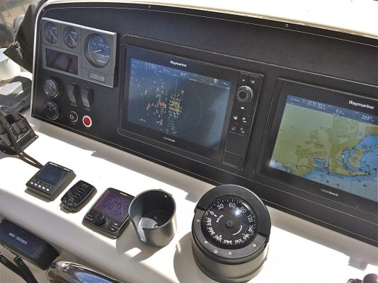
I currently run Nobletec VNS 11 on a laptop as my primary chartplotter. I have another laptop in the captains berth and an extra computer for backup.

Recently I purchased an Ipad mini 4 for personal use, that I really enjoy.

Doing some research, for fun really, I though I would experiment with a chartplotter app.

I bought Inavx after ready some positive reviews and confirming that it would work with an external GPS. It wasn't cheap at $50 bucks but was a fraction of a boat unit... This plotter was a poor choice for me. The charts are expensive! $300 every two years for the west coast of the US and Canada??? Too much. Also the charts are difficult to select and navigate. this would have improved with the learning curve but I was turned off by the price of the charts.

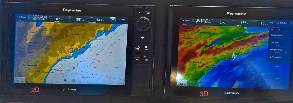
Chartplotter App. #2 was NobleTec Time Zero. The app was free and charts for the same area was $100. This software works seemlessly with an external gps and the charts are easy to navigate and it is easy to select charts to load for the regions you intend to visit.

Just adding my 2c. after being disappointed with Inavx...
 
I, too, am not satisfied with iNavx.

Can the NobleTec Time Zero app import .kmz files? I have a lot of waypoints and routes in that format.
 
I'm not sure if it will serve all of your particular needs but we really like the Garmin Bluechart Mobile.

Really easy and overlays weather radar and Activecaptain.

Wife and I greatly prefer this over the one that came as stock on the boat.
 
FYI, I also added an external gps since my ipad was only wifi. Skypro xgps160. Picks up a signal inside the aluminum bridge of our boat. Interesting Glonass signal strength seem about equal to gps. It will be interesting to see how the signal works further north
 
I'm not sure if it will serve all of your particular needs but we really like the Garmin Bluechart Mobile.

Really easy and overlays weather radar and Activecaptain.

Wife and I greatly prefer this over the one that came as stock on the boat.

Ditto. Love Garmin Bluechart.
 
I run iSailor with an external Dual GPS. The PNW and Canadian charts are accurate and inexpensive. Also works with the iPhone as a backup or pocket plotter for the dingy.
 
isailor is the go for ipad,iphone,ianything.


Once you have used isailor you wont bother with anything else.
 
The New Amazon Fire is a great tablet , and its under $50.

Any way to use it and gov charts with a GPS stuck on?

Fire - Amazon's Official Site - Learn More - Amazon.com

www.[B]amazon[/B].com/Fire-Display-Wi.../B00TSUGXKE


Amazon.com, Inc.


Fire, 7" Display, Wi-Fi, 8 GB - Includes Special Offers, Black. ... Beautiful 7" IPS display (171 ppi / 1024 x 600) and fast 1.3 GHz quad-core processor. ... Free unlimited cloud storage for all Amazon content and photos taken with Fire devices.
 
I agree with the comments re iSailor, but Navionics also goes well on iPad.
 
I don't think Navionice does heading up , which I prefer.


I reckon the charts on isailor are clearer and are always downloaded so no internet required and, from memory, cheaper.


isailor..no brainer for me,and I have used the isailor from Whitsundays to Wilsons Prom and have found the charts to be amazingly accurate even through Great Sandy Straights and through the back way between Gold Coast and Morton Bay.


AIS overlay is vey good to.


I am a big fan :)
 
iSailor was developed by Transas. They only use Transas charts. How many of you have heard of Transas let alone even knew they were a chart publisher? They're a company specializing in ship ECDIS systems. Their HQ is in Ireland but all their technology and development happens in Russia. I'd bet their commercial port charting is pretty good. Creeks off the beaten path? ...not so much.

Go to transas.com and see how much recreational exposure you see.

Jeppesen/C-Map (now a part of Navico), Navionics, and Garmin specialize in recreational charts. Each of them maintains their own chart portfolios. For the US, many products use the free NOAA RNC and ENC charts. NOAA's main concern is commercial ports and charts for military use although they've been doing much more recreational updating.

In my opinion, selecting a chartplotter display app shouldn't be based on the app. That changes easily. It should be based on the charts. So perhaps the user-interface of iSailor is attractive to some people. It's just the wrong place to start.

Personally, I prefer Jeppesen/C-Map and Garmin. And it's not because those 2 use ActiveCaptain. Navionics requested an ActiveCaptain license and I turned them down because of past experience with the company. For me, the honesty and integrity of the company matters too. But the Navionics app is pretty good and I couldn't fault anyone for using it.

The reason so many people love the Garmin app is because it has an excellent user-inteface, is obvious to use, and has exceptional charts. If the Garmin charts were crummy, you'd have a wonderful app that drove you into the rocks (!). Think about that when you consider iSailor.

And for what it's worth, iSailor approached us to advertise and pay us too. We thought it was the wrong thing for our user base so we rejected the offer.
 
Gee it seems that someone is getting a bit "testy" about isailor.
I don't know what tie up you appear to have with Garmin or Navionics but it seems to me you must have one.


And I don't know about NOAA RNC and ENC charts or ECDIs or Active Captain for that matter, all I do know, from personal experience is that isailor has proven to me that its charts are as good or better than any of the charts I have used in Navionics or my Raymarine CMap charts ESPECIALLY in the backwaters of Australia.


It seems to me that if they bothered to get it right in Australia its pretty fare bet that they would be equally as good if not better in the rest of the world.


Furthermore on two occasions when I have wanted some questions answered they came back to me almost immediately via email with the answers. Admittedly they did seem to have quite Russianized English but the support was great compared to most.


For the money which is not much at all my advise to anyone wanting ipad navigation you would be stark raving mad not to try isailor.


All my friends use it now it is the cleanest simplest and probably the cheapest way to go, I would say do yourself a favour and try it, its not difficult.


I think that this was the question first put in this thread.


You know the old saying "Don't knock till you've tried it" :)
 
Another positive experience with Garmin Bluechart Mobile here. I use it on a full size iPad and it has been flawless. And I think it was like $29?

If I can use it, it's easy to use! (My new tag line).
 
We've been using navionix last 2 years as a back up and love it. Charts and ease of use very good.
 
Navionics on a new iPad. Better than my Standard Horizon plotter, faster, touch screen, heading up, built in gps. Just spent $100 to upgrade the SH plotter but now I think I'm going to just keep it for backup for the iPad. Need a nice mount so I can use it vertically and swivel. Oh yes, iPad is sunlight viewable. Haven't tried to dim it for night yet. Plotters are history.
 
Gee it seems that someone is getting a bit "testy" about isailor.

Not really. Why does giving an opinion based on adding some facts that most people probably didn't know considered to be "testy"?

Yes, I have a relationship with nearly every marine electronics manufacturer. But I'm also a cruising boater and I'll call 'em as I see 'em.

If iSailor is working great for you in Australia, great. Perhaps the Garmin app would be even better. Do you know?
 
I considered the Navionics app, but the web site referred to a subscription service but didn't mention the cost. How much is the subscription and what do you get for it?
 
I don't think Navionice does heading up , which I prefer.

Andrew, my Navionics on the android tablet has an icon in the lower left corner that selects various display modes, including track up. It's the icon with the line extended ahead of the arrowhead. It toggles through the choices as you tap it.
 
As strictly a backup I use Navimatics Charts and Tides. It is a rudimentary chart platter that uses vector charts. I particularly like the ability to click on a T or C symbol and get the tide or current diagram for that spot. I think it cost $10 for the east coast charts.


For raster charts which you sometimes need, I use PolarView Mx which is free. It is a more rudimentary plotter. You have to load charts via the NOAA list, so it is not as nice as Mx Mariner for Android which lets you download entire NOAA regions. For a free raster chart plotter Mx Mariner is by far my favorite, but alas my Nexus 7 sort of died so I now use an iPad.


If I were going to use the iPad as my exclusive chart plotter I would use something more sophisticated like Navionics, but for backup these work fine.


David
 
I'm not much of an iPad guy but I can understand why people use them. Their Nav charts (many different ones) are very cost efficient and I suppose that's the main reason for so many using them.

I'm an MFD kind of guy and like my electronics flush mounted right in front of my face. The new MFDs are incredible! The resolution, detail, coverage, & intuitiveness are better than ever. (ie:) The Raymarine Es127 & 128 come packaged with Lighthouse, Navionics and C-Map as menu items. I've been a Navionics guy for years but am thoroughly impressed with the C-Map cartography at present. Zooming in & out is done with a knob and is really nice when you are entering waypoints. Same with the radar...turn the knob to zoom out or in. Each device, radar, plotter or fish finder has its own manual...on board! No paper books any more!
 

Attachments

  • New PANEL 1.jpg
    New PANEL 1.jpg
    171.2 KB · Views: 82
  • 2 Charts  2D & 3D.jpg
    2 Charts 2D & 3D.jpg
    78 KB · Views: 78
Check out SEAiq at SEAiq.com it works on many platforms. You can even download a free version to test. It also uses NOAA charts which can be downloaded for free. If you purchase it you can also intergrate with Active Captain.
 
"If iSailor is working great for you in Australia, great. Perhaps the Garmin app would be even better. Do you know? "

I am sure that Garmin mobile is excellent however I believe it did have issues in the beginning. I have used Garmin extensively over the years with road navigation and Blue Charts on a Palm pilot and it was fine back then, apart from the rigmarole involved in downloading and unlocking maps that drove me mad.

I have tried and still use for camparison at times Inavx,and Navionics On laptop I have Memory Map for raster scan charts , Open CPN and SOB Max.
I also have a near new Raymarine 120 chart plotter(stupidly I did not get touch screen), to many extra dollars, so I drew the line.

The Raymarine I hate most, poor interface, cumbersome to use, poor navigation info boxes, and in places less detail than isailor, I have them side by side in my wheelhouse , so I make direct comparison.

By comparison Garmin app is much more money and you have to pay for updates!! Charts are much more expensive to, I cant see the benefit in paying more and not getting more.

With isailor I got the app for free, downloaded and purchased charts once, very well priced ,I have it on three ipads and two phones, I have it on the flying bridge, in my stateroom, on the bar, and in my pocket, on every device. I bought it once, I paid once, and all updates for all devises are free forever , so it seems. I have had it now for three years I think and have cruised the East coast of Australia and been into some very tight locations and bolt holes. The depth contours are incredibly accurate.

The thing I love is that I do not even think about which app or which device any more, isailor does it all for me.
Simple clean charts with fantastic detail, great interface with all info you need on one page, heading up (I know navionics does that now), full transfer of all tracks, waypoints etc between all devices including Raymarine, and really easy to use, redundancy due to multiple devices, AIS, tide data, weather, etc. Plus charts are all on board so no downloading, no internet required just ipad gps, I don't even use external gps sensor, never needed it, even though I have one.

Mapping by Transis that I believe every large ship on the ocean uses, so it cant be all that bad can it? I know this because I asked them if I could get a PC based software package and they told me that it is mega bucks for ships.

All for one once of payment.

What is there not to like?

And no I do not work for them and have no association with them I am just a fan.
 
What is there not to like?

It's the charts. Just like you stumbled upon, Transas charts are made for ECDIS systems for ships. I'll bet the charts for Sydney are spectacular. But find a small bay somewhere with just a few meters of depth, and the charts are likely to be quite poor.

Of course the Transas chart updates are free. What's getting updated are the shipping lanes. How much effort is going into digitizing the recreational areas? There is no free lunch.

Without charts myself of Australia, I can't prove it. But I'll challenge anyone to upload a screen shot of iSailor around Big Majors in the Bahamas. I'll upload the same area from Garmin. Let's compare...
 
All I can say is this definitely not the case here in the areas I have used isailor.


I cant comment for Garmin App but I can tell you that in an area of Australia called The Great Sandy Straights they are notoriously narrow, shallow, and tidal, this together with Hervey Bay are very dodgy areas as far as charts go. What we have done on a regular basis is go along slowly all of us peering at the ipad watching a contour approach where it may go from say 6' to 30' , hearts pounding. thinking can we trust this map? And everytime the chart was true, we cheer have another beer and carry on to the next shallow patch.


I can assure no ship would ever be in that area, you can say what you like I am basing my opinion on hands on experience comparing our sounder to the charts.


We time and time again could never figure out how these charts were so accurate.


My crew have actually said that they "trust them with their lives" !


There are places where we have been that are not charted that are locally known that we have gone into on waypoints provided by local knowledge but no charts we posses have these place charted accurately or at all. If we have found an error like the placement of a mark for example as has been the case on occasion we check the Raymarine Cmap and it has been wrong aswell as has been Navionics.


Anyway you can say what you like you will not convince me or anyone that I know that uses isailor that the Transis charts are not as good or better than any others we have tried in our part of the world.


Anyway no point debating it here, just download it and have look at it , if you don't like don't use it.


I have personally wasted a lot of dollars on trying this and that and always come back to isailor bcause its good for me.
 
iSailor is the backup for my Garmin. Each has its place.
 
Is anyone here familiar with the crowd-sourcing of bottom depth for Navionics charts? I read a great article about it but can't research it right this moment.

From what I've seen in the CA Delta, it's made a significant improvement in bottom depth accuracy. And....after all, isn't that why we have chartplotters and depth sounders...to stay off the bottom?
 
I bought Inavx after ready some positive reviews and confirming that it would work with an external GPS. It wasn't cheap at $50 bucks but was a fraction of a boat unit... This plotter was a poor choice for me. The charts are expensive! $300 every two years for the west coast of the US and Canada??? Too much. Also the charts are difficult to select and navigate. this would have improved with the learning curve but I was turned off by the price of the charts.

...

I am not sure where you got the $300 price from, but NOAA charts for US waters are free. Charts for all Canada cost $99.95. I just finished downloading NOAA charts for all the Great Lakes, and I didn't have to pay anything. I don't find it difficult to select charts, since iNav-x does this for me. I suggest that you download the users manual so that you can understand all the features of this app.

I have been using an i-Pad and i-Navx for five years. I initially bought it as a backup, but it was so much better than my chartplotter that I now use the chartplotter only as a radar display.

For me, one of the biggest advantages of using an i-Pad is that there are many nav apps available. Unlike old style chartplotters, I am not stuck with the software that comes with the device. Someday I may find an app that I like better than iNav-x. If I do, it will be easy to switch.

A good place to read about boating apps is here: i-Marine Apps
 

Latest posts

Back
Top Bottom