The Furuno rep laughed at me

The friendliest place on the web for anyone who enjoys boating.
If you have answers, please help by responding to the unanswered posts.

JC

Member
Joined
Sep 16, 2010
Messages
22
In a good natured way. We purchased our Albin 28 just a few months ago. It came with a 10 year old Furuno 1650 Chartplotter. After getting the boat out here, the local Furuno dealer was nice enough to come to the boat and spend an hour with me, teaching me how to work all the electronics. At the end of the session, he determined that I need to order the Navionics chip that covers SF Bay (the boat was bought in MD).

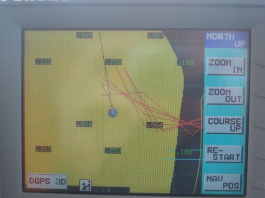
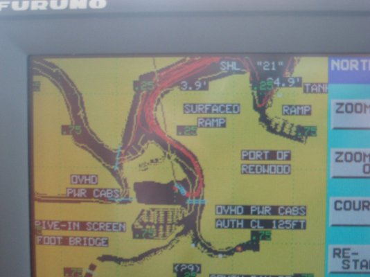
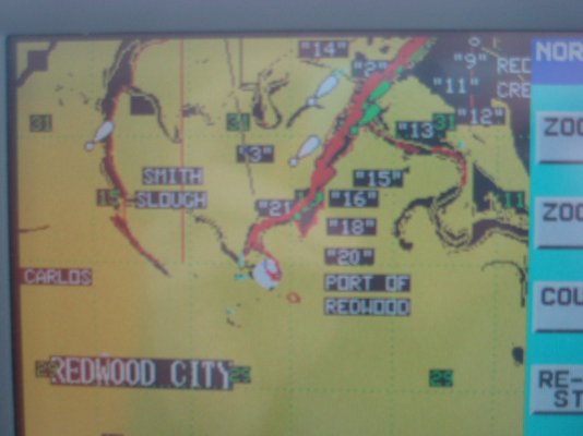
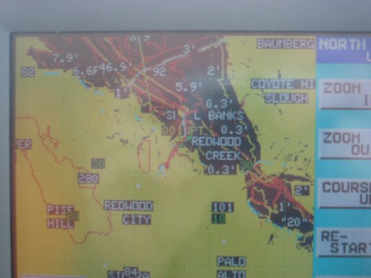
Fast forward 2 months. The chip has arrived and works fine in the unit. BUT I seem to be getting tracks for more than just my boat! I went through the process to clear all the tracks off, and after a week, more appeared again. The tracks go to parts of the Bay I have never been to, even to other slips in the marina we use. And no, nobody else is using my boat. I tried to explain all this to the Furuno retailer and he was amused (he is aware just how much of a rookie I am). He calmly explianed that the set could not possibly be picking up other boats tracks. So what the hell are all these lines??? They are not depth contours, they are lines just like the track of my boat, and they go to other slips in my marina, and other marinas.

Anybody ever see this before?
 
The Albin 28 is a fine boat.* Mine was called "God's Pocket", which I still think is a good boat name.

Clearly the vessel is haunted, and you run the risk of teleportation into a parallel universe.* You can only hope that diesel is cheaper there.
 
This is total speculation--- I have never seen this phenomenon although we run C-Map, not Navionics in both our plotters. But is there any chance that Navionics includes pre-plotted courses between the more commonly used or popular destinations in an area? And that this is a feature that can be turned on or off via a menu selection somewhere?

Courses from a previous owner would seem to be ruled out since you took the boat out west, not the previous owner.

Or is your wife/significant other putting these ghost courses in when you're not around to spook you?

But deep down, I'm with Delfin.* I think your boat has a poltergeist.
 
JC wrote:They are not depth contours, they are lines just like the track of my boat, and they go to other slips in my marina, and other marinas.

Anybody ever see this before?
I think you should really check your hour meter and fuel gage. The PO might have
had a partner in the boat and said partner doesn't know it's been sold.

*
 
Sounds to me like you have a used chip in them there plotter.
 
I may be mistaken--- I'm used to C-Map, not Navionics--- but I don't believe user-entered waypoint, course, and tracking data is stored on the chart chip or SD card. It's stored in the plotter itself. The chart chip or card simply provides the charts.

One reason I'm real sure of this, at least with a C-Map Furuno, is that our unit uses SD cards, and as soon as we installed the unit I slid the record-safety switch on our two cards to "Safe" which means nothing can be recorded on them. This has not impaired the storing of waypoints, the creation and storage of routes, or the storage of tracking info. Since this information is physically blocked from being recorded on the card, the only place it can be going is the plotter circuitry itself.

So even if JC was given a used card, I doubt there is any waypoint, course, or track information on it from the previous owner.

-- Edited by Marin on Tuesday 15th of February 2011 10:28:41 PM
 
Must be tracks from the PO. Why they're not deleting I don't know. Your right Marin about the C-Map chips, I'm not sure about the Furuno though.
 
JC wrote:
--------------------------------------------------------------------------------


Anybody ever see this before?


--------------------------------------------------------------------------------

No, but we have 2 older pieces of Furuno equipment and have dealt with Furuno tech services via email with good success. They assign a case number and track it and are located in Camas, WA so you're on the same time zone anyway.

Good luck.

http://www.furunousa.com/Support/FAQ.aspx

Larry/Lena
Hobo KK42
Puerto Medero, Chiapas, MX
 
Somebodys using your chart chip while you are not there.

Follow the track to the other boat slip in your marina and tell them to stop it.

lol.* JohnP
 
Can chips get re-cycled in these tight financial times? Maybe.*If the new data was burned into a poorly*deleted older chip that had embedded tracks,*your tracks may indeed be from another voyager. For fun, you could follow the tracks to find out who the other voyager is. This is similar to the rental or used car*navigation systems - old data gets displayed.

Do you have a teenage son?
 
sunchaser wrote:

Can chips get re-cycled in these tight financial times? Maybe.*If the new data was burned into a poorly*deleted older chip that had embedded tracks,*your tracks may indeed be from another voyager. For fun, you could follow the tracks to find out who the other voyager is. This is similar to the rental or used car*navigation systems - old data gets displayed.

Do you have a teenage son?
I think Sunchaser is on to something.* It sounds like a chart was turned in on an upgrade and tracks not erased.

If not, I agree with Delfin------Definitely haunted.

by the way Sunchaser, I like that name.

*
 
The first thing I would do is find out if the Navionics chips or cards actually store any user data. As I said, C-Map cards do not. If you're told that the Navionics cards are the same---that they only provide the chart data--- then the problem lies somewhere in the Furuno unit itself. For some reason it is not clearing previously-entered routes although why they would appear at random I don't know.

The fact the unit was on the boat when you moved it to SFO would make it very odd that it would be displaying courses in SFO Bay. How would they have been entered? If Navionics does put user data on the chart card, then a new card should fix the problem.
 
can you post a photo of what you are seeing on the screen?

barring that, I'm going to have to go with your boat being haunted.*
 
Have you tried putting the old chip back in and then wiping the track memory?

Ted
 
I would think the tracks were recorded from trips made by the previous owners which the chart plotter has in it's memory and are now being depicted on the map. Simply go into the chart plotter's preferences and erase all tracks and I think you'll probably solve the mystery......, Oh, you tried that, guess it is haunted. Maybe it's trying to tell you something.

SteveH


-- Edited by SteveH on Friday 18th of February 2011 09:07:13 PM
 
For all of you "old track theorists".....the boat came from Maryland!!!! How could there be "old tracks" in SFO Bay????
 
But Baker, the rep provided a*so called new*chip*for the*SF Bay area. The problem started when he started operating off the new chip. Who knows what was on the so called new chip?

My advice, get the Furuno guy to give you a really new chip.
 
4 images, all one level of zoom out from the previous.* my boat has never been off the main grouping of track, and has only been out MAYBE 5 times since I cleared the memory.* Something is going on, and its not ghosts or my boat.
 

Attachments

  • blue moon 025.jpg
    blue moon 025.jpg
    185.9 KB · Views: 89
  • blue moon 026.jpg
    blue moon 026.jpg
    124.6 KB · Views: 78
  • blue moon 027.jpg
    blue moon 027.jpg
    117.5 KB · Views: 94
  • blue moon 028.jpg
    blue moon 028.jpg
    127 KB · Views: 99
Have you found out if user data is stored on a Navionics chart card? If it's not, it's either not your card or the chart data on the card has become corrupted for some reason. Given that it appears that some of the track lines, particularly in your first photo, aren't even confined to water I doubt they are previous user track lines. Or they are, from back east, and are being layered over your SFO charts for some reason. Which would be the display unit's problem, not the card's problem.

Do you*have*another card for*your or any*another area, and if so, have you put it in to see if random tracks appear on the display?* Or do you have the card for wherever the boat was back east?* If so, put that in and see what*happens. *Since the Furuno rep was willing to come to your boat the first time see if he'll come to the boat again with a different card to see if it makes any difference.

-- Edited by Marin on Monday 21st of February 2011 05:31:12 PM
 
My bet, other than the obvious extra dimensional haunting theory, is that what you are seeing is test code.* If it is a new chip, it has happened many times before that test routines are embedded, inadvertantly shipped with the finish code and for some reason you are displaying those routines.
 
Both the furuno dealer and their tech support guy have said that the chip does not store any data. The chip was brand new, right out of the sealed pack. It was an older version and had to be backordered.

The first pic with max zoom for some reason doesn't show my marina, even tho it shows up ok in the next pic. I don't know why, but this seems unrelated to my multiple track problem.

My radar is connected to the chart plotter. Could the plotter be picking up tracks from the radar (also furuno). I don't know what other reason there is to have the radar and chart plotter connected?
 
I'm not familiar with the Furuno you have. The 1734C/NT NavNet VX2 we have is a radar and a GPS plotter (it can also be a depth finder but we did not get it with that function). There is a black box you can buy for the NavNet that will overlay the radar onto the chart display. The black box tells the radar where north is--- that's the only way the two images can be superimposed accurately. If your radar can be superimposed onto your plotter display via one of these "black boxes" I suppose it's possible you could get random radar tracks if your radar has a track display feature. But your Furuno support people should know if this is even possible. Try disconnect the radar from the plotter and see if the tracks go away. My money is still on the plotter unit having an internal fault of some sort but there are plenty of variables here.
 
An update:

It hasn't been great boating weather, but I did get to the boat last week and deleted all tracks again. I also changed the color of all the depth contour lines. It appears that 2 or maybe all 3 of the three automatic lines (less than 10', etc) were being drawn in the same color as the course track. That doesn't explain the apparent different slips in my marina, but it might explain the "tracks" to the marinas i have never visited. The area of the bay where I have been boating can be quite shallow, so there are "less than 10' ", "less than 20'" contour lines all over the place.
 

Latest posts

Back
Top Bottom