First prize, if you ran Refugio through there without diggin' a new ditch. Depth not such a challenge as width. Ran a 34 Sea Ray through but went fast enough so's only the props and rudders were in the water.And for the really adventurous, who's taken their vessel (not dinghy) through "The Gut"?
You are using an out of date browser. It may not display this or other websites correctly.
You should upgrade or use an alternative browser.
You should upgrade or use an alternative browser.
Port Townsend Canal
- Thread starter dhmeissner
- Start date
The friendliest place on the web for anyone who enjoys boating.
If you have answers, please help by responding to the unanswered posts.
If you have answers, please help by responding to the unanswered posts.
My 28 Spirit would go through, legs up, almost any time.Used to take my 28' troller through "The Gut" when I lived on Thetis Island.
She had a 9 1/2 ft beam and drew 3 1/2 ft of water.
I wanted 4 ft on the posted pile and a rising tide, didn't always get both!
If I remember correctly, it took a lot of shouting from the locals to get it done in '14.We took the SC on our maiden voyage when we took possession of Phoenix Hunter. The channel is well marked, well surveyed and I think they keep it well dredged
http://www.passagemaker.com/article.../swinomish-channel-dredging-begins-this-fall/
Last edited:
Jay N
Guru
- Joined
- Oct 6, 2007
- Messages
- 502
- Location
- USA
- Vessel Name
- WESTERLY
- Vessel Make
- 1974 Pacific Trawler 37
After boating for a number of years, I've been through almost all the tight spots. The following assumes minimum 40' boat with 8 knot speed, and proper research and situational awareness.
Port Townsend Canal: There is plenty of room for single file traffic meeting, current can be challenging for slower boats. In my towing days, we used to routinely tow 180' x 50' barges with wood chips with an 80' tug drawing 12'. Every now and then, we'd bring log rafts through which could be 150' wide and 450' long. It worked fine if the tug stayed in the deep water channel. For those interested, check out 33 CFR 162.235a in the Coast Pilot 7 which specifies whistle signals prior to entering the canal, and a 5 mph speed limit. While the regulations are very old, there are still a few complaints from time-to-time from beach owners concerned with beach erosion caused by boats creating large wakes.
Swinomish Slough: Pretty straight forward as long as you have done your research for adequate draft, and air draft for sailboats. In my towing days, we occasionally would tow a 220' x 45' x 10' draft barge through here with a 10' draft tug. Even today, there are log rafts towed through here where they require most of the channel, but there is usually enough room to stay out of the way. Watch for minimum speed requirements, they may patrol for them in the summer months.
False Narrows: I like going through here because it eliminates the slack water congestion at Dodd Narrows and offers a much larger transit window. I use 7' of tide for my 4' of draft, a little current will help keep the kelp down.
Boat Passage: This spot requires some careful research and local knowledge. I wouldn't go through here the first time without taking your tender out on a preceding slack water and checking it out. There's about 30' of width available at high water slack, which is 45 minutes before Active Pass slack. If there are large tidal exchanges, the slack water doesn't last long. Also, actual slack may vary from book time up to 20 minutes depending on weather conditions and atmospheric pressure.
The Gut: High water spot only. We used to take our 40' boat through here frequently between Telegraph Harbor, and fishing at Porlier Pass. There should be water level gauges indicating water depths in the canal at the entrance markers at each end, but these are sometimes unreadable due to growth.
A few other spots: Canoe Pass, just north of Pass I in Deception Pass, is about 40' wide, slack water only. Pender Canal requires close observance of tidal height and air draft, remember those soundings are in meters.
Great comments Jay N. The only issue I ever had through Boat Passage was a kelp frond wrapped a leg and cut the water off. Stopped, backed a bit and carried on.After boating for a number of years, I've been through almost all the tight spots. The following assumes minimum 40' boat with 8 knot speed, and proper research and situational awareness.
Port Townsend Canal: There is plenty of room for single file traffic meeting, current can be challenging for slower boats. In my towing days, we used to routinely tow 180' x 50' barges with wood chips with an 80' tug drawing 12'. Every now and then, we'd bring log rafts through which could be 150' wide and 450' long. It worked fine if the tug stayed in the deep water channel. For those interested, check out 33 CFR 162.235a in the Coast Pilot 7 which specifies whistle signals prior to entering the canal, and a 5 mph speed limit. While the regulations are very old, there are still a few complaints from time-to-time from beach owners concerned with beach erosion caused by boats creating large wakes.
Swinomish Slough: Pretty straight forward as long as you have done your research for adequate draft, and air draft for sailboats. In my towing days, we occasionally would tow a 220' x 45' x 10' draft barge through here with a 10' draft tug. Even today, there are log rafts towed through here where they require most of the channel, but there is usually enough room to stay out of the way. Watch for minimum speed requirements, they may patrol for them in the summer months.
False Narrows: I like going through here because it eliminates the slack water congestion at Dodd Narrows and offers a much larger transit window. I use 7' of tide for my 4' of draft, a little current will help keep the kelp down.
Boat Passage: This spot requires some careful research and local knowledge. I wouldn't go through here the first time without taking your tender out on a preceding slack water and checking it out. There's about 30' of width available at high water slack, which is 45 minutes before Active Pass slack. If there are large tidal exchanges, the slack water doesn't last long. Also, actual slack may vary from book time up to 20 minutes depending on weather conditions and atmospheric pressure.
The Gut: High water spot only. We used to take our 40' boat through here frequently between Telegraph Harbor, and fishing at Porlier Pass. There should be water level gauges indicating water depths in the canal at the entrance markers at each end, but these are sometimes unreadable due to growth.
A few other spots: Canoe Pass, just north of Pass I in Deception Pass, is about 40' wide, slack water only. Pender Canal requires close observance of tidal height and air draft, remember those soundings are in meters.
"Local knowledge" is a great tool.
"And for the really adventurous, who's taken their vessel (not dinghy) through "The Gut"?"
When I had my sailboat with 4'6" draft I took her through. In the last few years I have dinghied through many times, and have noted a little silting in, so I wouldn't trust the marks on the pole. I would assume a couple of feet less than the pole shows.
When I had my sailboat with 4'6" draft I took her through. In the last few years I have dinghied through many times, and have noted a little silting in, so I wouldn't trust the marks on the pole. I would assume a couple of feet less than the pole shows.
DC36Monk
Veteran Member
And if you want narrow rock slot try Hurricane Pass about 15 miles north of Hakai pass. I have a 13 beam and bet there was an extra four feet between both sides. Gave me a tight pucker.
Another fun one is the entrance to Ire Inlet on the east side of Anger Island. There's a tree hanging out that can grab your rigging. One of the guidebooks tells the story of a sailboat that got the tree jammed in its shrouds with the ebb pushing it out of the inlet against the downed tree. You can see where they had to cut off the tree trunk to get by.
Here's a picture of the cut off log.....
Attachments

Jay N
Guru
- Joined
- Oct 6, 2007
- Messages
- 502
- Location
- USA
- Vessel Name
- WESTERLY
- Vessel Make
- 1974 Pacific Trawler 37
DC36Monk says: "And if you want narrow rock slot try Hurricane Pass about 15 miles north of Hakai pass. I have a 13 beam and bet there was an extra four feet between both sides. Gave me a tight pucker."
Assume you are talking about Spitfire Channel?
I've often thought about getting into Ire Inlet, but the tides have never been a good fit with our arrival/intended departure from the area. Instead, we use a nice anchorage through Ala Passage to the NE of Anger Pt. The story of the sailboat that came to grief there is scary - they could have easily have lost the boat.
Nomad Willy
Guru
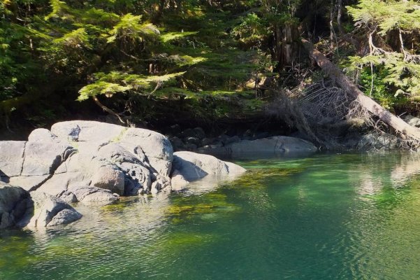
We've been into Ire Inlet.
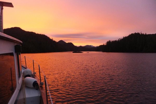
Stopped there on our way down from Alaska. Saw it in the Hemingway cruise guide. From these pics you can see it is tight. All pics taken w non-telephoto. We anchored in the very west end of the Inlet beyond the big rock. Not much room. Bad weather was coming and I used too much scope and banged against a rock in the middle of the night. I took up some rode in my shorts hoping that was that. It was and we left in the morning. The third pic is the sunrise in the am. More sign of bad weather to come. The next night we did the 50 knot gale in Patterson Inlet not far south.
We entered the Inlet in the right side of the first pic.
We were closer to the shore on the right in the second pic. Close to the leaning tree .. on the right.
With the very beginning of the gale to come there was a very slight E. breeze in the morning.
Attachments

Last edited:
Topic for a Video? Another that I would like is a transit of the Swinomish channel. I have always been nervous to try it in my sailboat. Not sure of the charted depths are fact or fantasy.
Good ideas! We actually have a time lapse going through the PT canal 4 years ago, with a go fast motoryacht passing us the opposite direction WAY too fast (and close). Only problem is I was playing with the interval on the GoPro and had that transit set at every 5 seconds. Too long. Made for "jerky" video. Might resurrect it, however...
And we did have a Swinomish time lapse (much smoother) back when the nav aids changed direction at La Conner. Those have since been made one direction, so we took down that video. I do have a new set of time lapse images, just haven't edited it yet. I'll let you know when it's done.
Don't worry too much about doing the Swinomish, though. Especially if you go on a rising tide at the southern entrance AND you stay within the channel, you will be absolutely fine. It's truly amazing how many boaters drift out of the marked channel and go aground (in fact that new time lapse shows a sailboat aground there!). My friend Capt. John Aydelotte owns the Vessel Assist in Cornet Bay, and he refers to that southern entrance/channel as the "Million Dollar Mile"!
dhays
Guru
- Joined
- May 26, 2015
- Messages
- 9,045
- Location
- United States
- Vessel Name
- Kinship
- Vessel Make
- North Pacific 43
I would enjoy seeing that. Jerkiness depends on the speed. Here is an example of a 2 sec time lapse I did in a car, speeds at times hit triple digits.
Nomad Willy
Guru
Re Swiniomish Channel,
Coming in from the south .. just after passing Goat Is don't think the channel is all the water you can see. Stay the same distance from your port side of the channel as you do passing Goat Is. And don't turn very late entering the dogleg if the tide is low. The next turn (by Lattitude Marine) can be almost hard against the rocks to stbd. Then to on to So LaConner stay generally or a bit to the right. Go slow going around the tight corners. Lots of traffic and many don't go slow. Many fishermen go planing around these corners giving little room. These are commercial crab boats.
Coming in from the south .. just after passing Goat Is don't think the channel is all the water you can see. Stay the same distance from your port side of the channel as you do passing Goat Is. And don't turn very late entering the dogleg if the tide is low. The next turn (by Lattitude Marine) can be almost hard against the rocks to stbd. Then to on to So LaConner stay generally or a bit to the right. Go slow going around the tight corners. Lots of traffic and many don't go slow. Many fishermen go planing around these corners giving little room. These are commercial crab boats.
Last edited:
drb1025
Guru
Here is a video lining up the range markers at the south end of the Swinomish Channel. I was heading south from Deception Pass and did not turn into the channel, but filmed this for fun.
https://youtu.be/wlib5_GaSos
https://youtu.be/wlib5_GaSos
dhays
Guru
- Joined
- May 26, 2015
- Messages
- 9,045
- Location
- United States
- Vessel Name
- Kinship
- Vessel Make
- North Pacific 43
That is helpful. Range markers are great, as long as you can seen them. I had a heck of a time seeing the range markers in Olympia at dusk in bad weather in January.
porman
Guru
- Joined
- Aug 21, 2014
- Messages
- 1,042
- Location
- USA
- Vessel Name
- Beach Music II
- Vessel Make
- 2003 Mainship 430 Trawler
That is helpful. Range markers are great, as long as you can seen them. I had a heck of a time seeing the range markers in Olympia at dusk in bad weather in January.
You mean you didn't sail right down the middle of Budd Inlet like the locals do? I don't see how they do that. They must know where all the bumps are.
dhays
Guru
- Joined
- May 26, 2015
- Messages
- 9,045
- Location
- United States
- Vessel Name
- Kinship
- Vessel Make
- North Pacific 43
This last time I actually did, but the light was fading as I reached the southern end of Budd Inlet so moved over to the channel.
I always would see the locals sailing around in the middle, but was too intimidated to try. This time, I just paid a lot of attention and made sure I cleared Olympia Shoal. I went the same way on the way North again. I am sure that East Coast sailors would laugh at my timidity, but I get nervous in depths less than 3 digits. lol
I always would see the locals sailing around in the middle, but was too intimidated to try. This time, I just paid a lot of attention and made sure I cleared Olympia Shoal. I went the same way on the way North again. I am sure that East Coast sailors would laugh at my timidity, but I get nervous in depths less than 3 digits. lol
Nomad Willy
Guru
I'm paying attention. Heading there soon.
MartySchwartz
Senior Member
- Joined
- May 26, 2011
- Messages
- 282
- Vessel Name
- M/V Knot Knormal
- Vessel Make
- President 41
You mean you didn't sail right down the middle of Budd Inlet like the locals do? I don't see how they do that. They must know where all the bumps are.
The marked channel in Budd Inlet is for the large ships that come into Olympia. The inlet itself is pretty much all 30' or deeper. Just pay attention to the charts.
Marty......................
sunchaser
Guru
- Joined
- Apr 9, 2008
- Messages
- 10,196
- Location
- usa
- Vessel Name
- sunchaser V
- Vessel Make
- DeFever 48 (sold)
Interesting discussion. A decent grounding is not cheap and sure can screw up a cruising season. Some of the above mentioned places I've transited with no issues, but clear weather trips only.
For the uninitiated Nakwato has currents approaching 10 knots routinely. But once you're in there better see it all and have adequate supplies and a reliable electrical system. Last summer we heard about 2 distress calls per day between Campbell River and Prince Rupert. Dinghy ropes around props seems an ever increasing occurrence.
For the uninitiated Nakwato has currents approaching 10 knots routinely. But once you're in there better see it all and have adequate supplies and a reliable electrical system. Last summer we heard about 2 distress calls per day between Campbell River and Prince Rupert. Dinghy ropes around props seems an ever increasing occurrence.
Last edited:
Jay N
Guru
- Joined
- Oct 6, 2007
- Messages
- 502
- Location
- USA
- Vessel Name
- WESTERLY
- Vessel Make
- 1974 Pacific Trawler 37
porman says: "Some of my sailboat buddies from Olympia told me there were some mounds in Budd Inlet that were less than 6 feet down at low tide. Maybe they were kidding around with me."
No, they weren't kidding. But they are all well charted these days. When you head south in Budd Inlet, you don't have to get into the ship channel until you get to Lt"5". Stay to the W of a N/S line from Lt"5" when you get further in, there are a few shallow areas to the NE of Lt"5".
This is the route that tug/barges typically go, and even small ships with light drafts.
dhays
Guru
- Joined
- May 26, 2015
- Messages
- 9,045
- Location
- United States
- Vessel Name
- Kinship
- Vessel Make
- North Pacific 43
No, they weren't kidding. But they are all well charted these days. When you head south in Budd Inlet, you don't have to get into the ship channel until you get to Lt"5". Stay to the W of a N/S line from Lt"5" when you get further in, there are a few shallow areas to the NE of Lt"5".
This is the route that tug/barges typically go, and even small ships with light drafts.
I have a waypoint set about midway between Dolflemyer and Cooper Pts and another set right between G5 and R6. It skims pretty close to Olympia shoals but stays in deep enough water. Cuts a fair bit of time off going west to the channel entrance like I used to do all the time.
OP
OP
dhmeissner
Guru
- Joined
- Sep 26, 2012
- Messages
- 1,569
- Location
- North America
- Vessel Name
- The Promise
- Vessel Make
- Roughwater 35
Hey, so this past weekend we finally tied up at our new slip in Port Hadlock. We ran from Kingston to PH in some snotty weather. Everything on The Promise worked just fine. By the time we reached Oak Bay and approached the canal the visibility was down to 1/4 mile. We are in B30.
hollywood8118
Guru
- Joined
- Nov 16, 2009
- Messages
- 2,381
- Location
- USA
- Vessel Name
- " OTTER "
- Vessel Make
- Ocean Alexander Europa 40
Hey, so this past weekend we finally tied up at our new slip in Port Hadlock. We ran from Kingston to PH in some snotty weather. Everything on The Promise worked just fine. By the time we reached Oak Bay and approached the canal the visibility was down to 1/4 mile. We are in B30.
Welcome to the neighborhood, your across the aisle and a couple slips down from mine.
Will keep a eye out when I go down there.
HOLLYWOOD
Nomad Willy
Guru
Didn't know there were "slips" down there.
Must have a breakwater of sorts for the summer afternoon breezes given their NW origin.
Isn't Port Hadlock one of the wood boat building centers in Puget Sound.
Must have a breakwater of sorts for the summer afternoon breezes given their NW origin.
Isn't Port Hadlock one of the wood boat building centers in Puget Sound.
OP
OP
dhmeissner
Guru
- Joined
- Sep 26, 2012
- Messages
- 1,569
- Location
- North America
- Vessel Name
- The Promise
- Vessel Make
- Roughwater 35
Attachments
Similar threads
- Replies
- 12
- Views
- 1K
- Replies
- 7
- Views
- 448