AKDoug
Guru
Hello all! I will "tell on myself" a good bit in this thread. I am going to focus on running a boat from Seattle to Prince William Sound in Alaska, two different trips in two entirely different kinds of boats.
My first trip was in a brand new Bayliner 24' Trophy in 1985, no experience in a boat this size, and no experience with the Inside Passage. I had the boat run for 10 hours by the dealership before I came down from Alaska to pick it up. All my equipment was delivered to the dealership where I bought the boat, and several days were spent assembling it all and storing it away before my wife showed up.
The locals watched me cut up a 600' anchor line, and wondered what the heck I needed that much line for. When I explained the trip and my destination to them they responded by bringing me all of their charts and books for the passage. I had to purchase NO charts, and some of the guide books had courses and reciprocals marked on the pages, and interest points and local history written on the land masses. Awesome!
When we left, we ran an average of over 200 miles a day, up through Nanaimo and Campbell river and on into Queen Charlotte Straight before stopping for the first night (just short of Alert Bay). The skies were gray, following winds and seas, the engine ran perfectly and we averaged 3 mpg, stopped for fuel at every opportunity.
The weather caught up with us just past Petersburg and we had to anchor for a day to let the wind pass us by before going on into Juneau, otherwise there was nothing remarkable about the trip. No deviation from a straight line of travel to Juneau. I had no autopilot, no GPS, no chart plotter, no auxiliary craft and no auxiliary power. Just an EPIRB, flasher type sounder, a compass, and a VHF radio.
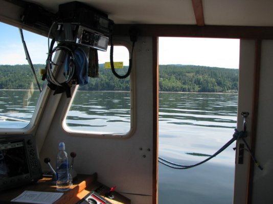
By comparison, when I left Anacortes in 2013 in the Willard, I had spent a couple of weeks going through a 13 year old boat that had sat unused and unloved on the hard for most of it's life. It had a VHF and a compass, nothing else. I installed a full Simrad electronics package, broadband radar, broad band sonar, chart plotter with GPS, and an auto pilot. I had the "Alaska" chip for the plotter, and a handful of large scale charts that would take me through the route with little detail. I also stuffed in a Fusion 700 iPod stereo and one pair of speakers")
I was also single handing, at least until Ketchikan, where a friend with an alcohol conviction was going to join me for the open water passage over the Gulf to the Sound. Canada hates alcohol convictions, no matter how old they are...
I was fortunate to meet a nice gentleman with a Nordy 40 in Anacortes, who gave me some handling lessons with my new full displacement boat, and a lot of travel tips. I knew I didn't want to fight the currents at Campbell river at 6 knots, so I went by the Northern route. I had borrowed a bicycle from the Harbormasters office in Anacortes for my stay, and after provisioning up (mostly) and returning the bike I took her out for a checkout of the autopilot. Once out, I said "what the heck" and headed North, spending the first night on a buoy just inside the border of the US. A short three hour run to Pender Island to Customs, cleared with a phone call, and I was on my way.
Here is where things began to not go according to plan. The Insight charts imbedded on the plotter were for US waters, and suddenly I had no charts in the plotter. They had been excellent while in the US, and suddenly there were no charts and I was on paper. Then, I saw a vessel coming through from the North so I decided I could cut through between the Islands, so I ran up into the bay and into the channel. I then found myself in a stream too narrow to turn around in, too fast to back out of, and so shallow I could see the bottom all the way through as it carried me through and spit me out the other side. Needless to say it scared the crap out of me! I assumed the other vessel had come through, in hindsight it was probably anchored in the bay and was coming out, there was far too much current for it to have come in against it.
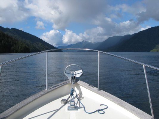
Now I felt I was in comfortable waters, and headed North up the inside of the island chain protecting me from the Straight of Georgia. I motored along at 7 knots, making about 6 against the current I would grow used to for the entire trip North. I jumped the Straight to the inside of Texada Island, confident I would find a place to anchor along the island for the night. Nope! I was finally worn to the bone, and anchored out in the open water off the Sunshine Coast Highway by Lois River, looking at vehicle lights on the highway and a few house lights, in 40' of water. It was an awesome and calm night, stayed that way and I got a good nights sleep.
The next morning I headed North again, sheet glass water, orcas splashing along off to port, coffee in hand and well rested. Of course, we all know it could have been otherwise. If need be, I would have motored all night. This was my first real realization that I would have to plan my anchorages much better at 6 knots than I had to at 24 mph...
I need to go do a few things, I will follow up with this thread a little later.
My first trip was in a brand new Bayliner 24' Trophy in 1985, no experience in a boat this size, and no experience with the Inside Passage. I had the boat run for 10 hours by the dealership before I came down from Alaska to pick it up. All my equipment was delivered to the dealership where I bought the boat, and several days were spent assembling it all and storing it away before my wife showed up.
The locals watched me cut up a 600' anchor line, and wondered what the heck I needed that much line for. When I explained the trip and my destination to them they responded by bringing me all of their charts and books for the passage. I had to purchase NO charts, and some of the guide books had courses and reciprocals marked on the pages, and interest points and local history written on the land masses. Awesome!
When we left, we ran an average of over 200 miles a day, up through Nanaimo and Campbell river and on into Queen Charlotte Straight before stopping for the first night (just short of Alert Bay). The skies were gray, following winds and seas, the engine ran perfectly and we averaged 3 mpg, stopped for fuel at every opportunity.
The weather caught up with us just past Petersburg and we had to anchor for a day to let the wind pass us by before going on into Juneau, otherwise there was nothing remarkable about the trip. No deviation from a straight line of travel to Juneau. I had no autopilot, no GPS, no chart plotter, no auxiliary craft and no auxiliary power. Just an EPIRB, flasher type sounder, a compass, and a VHF radio.
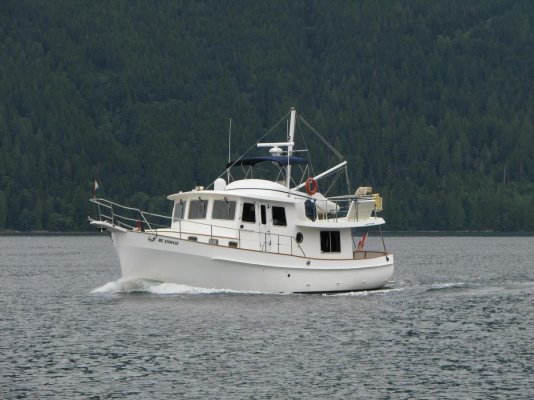
By comparison, when I left Anacortes in 2013 in the Willard, I had spent a couple of weeks going through a 13 year old boat that had sat unused and unloved on the hard for most of it's life. It had a VHF and a compass, nothing else. I installed a full Simrad electronics package, broadband radar, broad band sonar, chart plotter with GPS, and an auto pilot. I had the "Alaska" chip for the plotter, and a handful of large scale charts that would take me through the route with little detail. I also stuffed in a Fusion 700 iPod stereo and one pair of speakers
I was also single handing, at least until Ketchikan, where a friend with an alcohol conviction was going to join me for the open water passage over the Gulf to the Sound. Canada hates alcohol convictions, no matter how old they are...
I was fortunate to meet a nice gentleman with a Nordy 40 in Anacortes, who gave me some handling lessons with my new full displacement boat, and a lot of travel tips. I knew I didn't want to fight the currents at Campbell river at 6 knots, so I went by the Northern route. I had borrowed a bicycle from the Harbormasters office in Anacortes for my stay, and after provisioning up (mostly) and returning the bike I took her out for a checkout of the autopilot. Once out, I said "what the heck" and headed North, spending the first night on a buoy just inside the border of the US. A short three hour run to Pender Island to Customs, cleared with a phone call, and I was on my way.
Here is where things began to not go according to plan. The Insight charts imbedded on the plotter were for US waters, and suddenly I had no charts in the plotter. They had been excellent while in the US, and suddenly there were no charts and I was on paper. Then, I saw a vessel coming through from the North so I decided I could cut through between the Islands, so I ran up into the bay and into the channel. I then found myself in a stream too narrow to turn around in, too fast to back out of, and so shallow I could see the bottom all the way through as it carried me through and spit me out the other side. Needless to say it scared the crap out of me! I assumed the other vessel had come through, in hindsight it was probably anchored in the bay and was coming out, there was far too much current for it to have come in against it.
Now I felt I was in comfortable waters, and headed North up the inside of the island chain protecting me from the Straight of Georgia. I motored along at 7 knots, making about 6 against the current I would grow used to for the entire trip North. I jumped the Straight to the inside of Texada Island, confident I would find a place to anchor along the island for the night. Nope! I was finally worn to the bone, and anchored out in the open water off the Sunshine Coast Highway by Lois River, looking at vehicle lights on the highway and a few house lights, in 40' of water. It was an awesome and calm night, stayed that way and I got a good nights sleep.
The next morning I headed North again, sheet glass water, orcas splashing along off to port, coffee in hand and well rested. Of course, we all know it could have been otherwise. If need be, I would have motored all night. This was my first real realization that I would have to plan my anchorages much better at 6 knots than I had to at 24 mph...
I need to go do a few things, I will follow up with this thread a little later.