I am in an anchorage now with perhaps 200 boats. My guess is that all but a handful have physical boat cards (excluding the charters of course) and only a handful have electronic cards. But then we don't have an internet connection in most anchorages.
And if it were 1992 again, there would be few, if any, boats in your anchorage with electronic charts. Today, they all have them. The digital technologies sort of do that when there is a compelling advantage.
I fully admit, we're in the beginning days. That's the part of technology where I like to be.
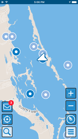
So look at the attached picture - it's real showing where I'm anchored right now. The white triangular cursor is my location. It's white because I'm not transmitting it now from my iPhone (my boat uses DeLorme inReach to update my location to the location server). The dark blue icons are "friends" who I've exchanged electronic boat cards with. The light blue icons are boats with electronic boat cards that I haven't exchanged cards with. I can only get very limited information about light blue icons - their boat's name, hailing port, and the boater's names (which can be limited to just first names). Light blue icons only show up within 5 nm of my location. Tap on a boat icon and I can get more info on them.
What I'm working on right now is an integrated anchor alarm within this display. But it goes a step further. It'll optionally publish the amount of rode I've let out, my alarm limits, and where my anchor is actually located to the location server. So when I leave my boat, I have a remote anchor alarm because inReach is still updating my location.
But there's even more...
Since the anchoring specs are also published, I can view the specs of the boats around me if they allow. I can see where they are in their swing and even set a contrasting alarm on them to warn me in the middle of the night if they're dragging. When I arrive, the display assists me in figuring out my swing area and how it'll fit in with the surrounding boats even in low wind situations where boats are not at the end of their rode.
Since it's 5 pm, none of the boats around here are moving. If they were moving, that dot in the center of their icon would show their course. Tapping on them gives their speed, etc, along with access to their electronic boat card. All of those icons show them as anchored.
I'm not saying this will be the winner in the electronic boat card battle that will surely take place. But something like this will be as common as electronic charts in another 20 years. Maybe 5.
") .
.
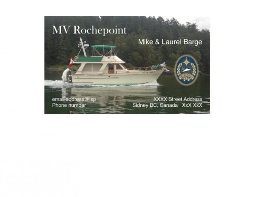
 . It was so easy to do.......here is the redacted version of our cards.......