Active Captain

The friendliest place on the web for anyone who enjoys boating.
If you have answers, please help by responding to the unanswered posts.
So I have ordered a laptop, GPS antenna and a 12Vdc power plug for the computer. I should be able to go to the Active Captain web site and download it correct?
 
well...not exactly if I understand you correctly.


To use the web site, you need the internet.


However, you can download the AC Companion...and that will reside on the computer. It only has a basic mapping program so it is useful, because the data is now stored on your computer you can look most things up, but for searching and mapping...a little limited. It is also frozen I time when you download it so you have to refresh it as often as you feel necessary.


The companion on a phone or tablet running all the time with GPS will alert you to upcoming hazards....not sure if all or even any laptops will do it though.


I will defer to better experienced users...but two different tools run on 2 different operating systems from what I have seen.
 
Last edited:
AC works as an overlay with other programs. I installed Garmin Blue Chart mobile on the Ipad with the AC overlay. I also have Polar navy with the laptop using a GPS puck plugged into a USB. Both were very cheap and worth their weight in Gold. My wife takes the Ipad to the shady part of the fly bridge and gives me directions. Thats the beauty of the Ipad. Then we can take it down in the salon at night. We love it.
 
So I have ordered a laptop, GPS antenna and a 12Vdc power plug for the computer. I should be able to go to the Active Captain web site and download it correct?


Not exactly. ps and Magna posts are germane.

First, install a nav program that integrates AC and will work with your GPS antenna. Then use that nav program to "go get" (technical term) all the charts you want, and current AC data. Use the nav program to update AC data from time to time.

I chose a nav program that is highly compatible (same engine) with my chartplotter. Another way to choose might be to select something that uses "the other style" of charts; if your plotter only presents vector charts, maybe choose a program that uses raster chart, or vice versa.

If you don't have a backup but do have tablets of some sort, you can also load nav apps there that will integrate AC data.

-Chris
 
mmmm OK now I am a little confused. In my MFD I am using Navionics (if this matters).


So as an example, I would need to upload Navionics or Garmin blue charts and then use AC as an overlay? I will not have access to the internet most times....
 
mmmm OK now I am a little confused. In my MFD I am using Navionics (if this matters).


So as an example, I would need to upload Navionics or Garmin blue charts and then use AC as an overlay? I will not have access to the internet most times....


Not familiar with Navionics, but yes that might be a good example if there's a Navionics version or companion program that will run on a laptop.

And the reason for using AC data as an overlay in that nav program is indeed specifically because we assume you won't have internet access while underway. Pre-loading the charts into your nav program -- and the AC data -- means everything you need will now be residing on the laptop, no internet required.

Think of it as components within a system:
- laptop (with OS, etc.)
- GPS source
- nav prog
- charts
- AC data
- any other useful overlay data your nav prog of choice allows

-Chris
 
.... I will not have access to the internet most times....

Before you leave your home base, download Active Captain Companion. From the AC web site.

The Companion displays a map background using streetmap data. The Up Ahead section shows what's coming next. Tap that to display the list of items in your path. And as you move along the water, you'll be warned and the lists will automatically update.

The Companion keeps the entire database of ActiveCaptain markers downloaded for offline access. No internet connection is needed to display marker details and reviews. When you have a network connection, you can update the offline database from the ActiveCaptain server to guarantee that you have the very latest updates and reviews. Do that before heading out especially to get the latest hazard information.

 
I will not have access to the internet most times....

None of the dedicated navigation equipment on our PNW cabin cruiser is capable of connecting to the internet or displaying Active Captain data.

However, we have a couple of iPads, my iPad II and my wife's newer iPad Mini. As we have a shared data plan, both the iPads have an application called Navimatics on them. This is a very good charting application. It is NOT a navigation application although you can put a Point A to Point B straight-line course in it and follow that. But it doesn't store waypoints, make and store multiple-leg routes and so forth like an actual plotter.

It will track your position across the chart and it will leave a dotted line track behind you if you so desire.

Navimatics was one of the earlier charting applications capable of downloading, storing, and displaying the Active Captain data base. As such, it has become a very valuable tool for us. We use it as one would use a stack of charts to quickly get the big picture or focus in on a detailed look, something that can be time consuming to do on an actual plotter. With Navimatics and the iPad, one can zoom from a view of the entirety of Vancouver Island and then some into a detailed shot of just our portion of our home harbor with a couple of finger swipes.

The chart displays also have tide and current stations that can be tapped to get this information.

And as our iPads are both wifi/digital models they have stand alone GPS receivers so will track us anywhere on the planet with no connectivity at all.

As Larry said, you can download the Active Captain database when you have connectivity, either to an iPad or a laptop or whatever. The device will retain the data base from then on--- you don't have to have connectivity to use it. You do to update it, but not to simply use it.

The Navimatics app we purchased (I think it was about $25) covers the entire west coast of the US and BC and all of Alaska and Hawaii.

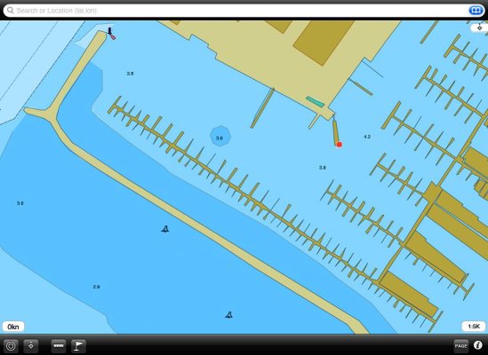
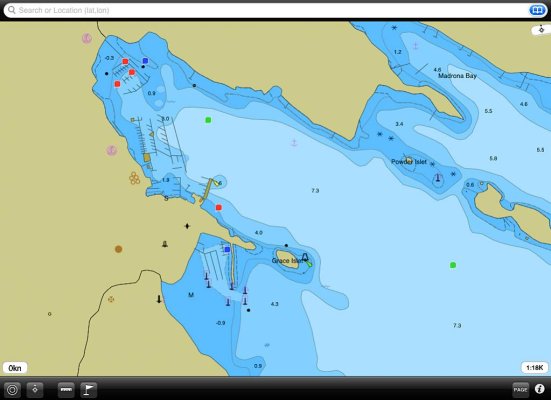
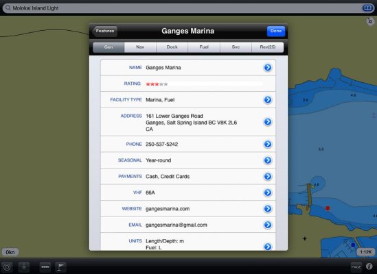
The screen grabs below illustrate from top to bottom the maximum area of coverage, the minimum area of coverage, the harbor at Ganges on Saltspring Island, the Active Captain info page on Ganges Marina and the review page for the marina. The little colored squares on the chart displays are the data points for Active Captain. Tap these and the Active Captain information screens appear as in the last two screen grabs below. The color of the square indicates the type of information it will bring up--- facilities, navigation, hazards, etc.

The last photo is our setup at the helm when we're underway.
 

Attachments

  • Navimatics 1.jpg
    Navimatics 1.jpg
    87.5 KB · Views: 79
  • Navimatics 2.jpg
    Navimatics 2.jpg
    84.9 KB · Views: 126
  • Navimatics 3.jpg
    Navimatics 3.jpg
    67.4 KB · Views: 133
  • AC 1.jpg
    AC 1.jpg
    70.7 KB · Views: 128
  • AC 2.jpg
    AC 2.jpg
    85.4 KB · Views: 146
  • Skipper.jpg
    Skipper.jpg
    137.7 KB · Views: 156
Last edited:
AC Integrated Nav App for Android Tablet

Marin,
Are you aware of a Navigation Ap that works on Android Tablets and will integrate with AC. I looked up Navimatic and they only have ap for IOS. My MFD is 8 years old and doesn't support WIFI, etc., so I would like to use my Samsung Galaxy Note 10.1 tablet. :confused:
 
Marin,
Are you aware of a Navigation Ap that works on Android Tablets and will integrate with AC. I looked up Navimatic and they only have ap for IOS. My MFD is 8 years old and doesn't support WIFI, etc., so I would like to use my Samsung Galaxy Note 10.1 tablet. :confused:

https://activecaptain.com/navProducts.php

That's the full list. Jepperson is the one I've see widely used but others may be more so.
 
I have MX Mariner on my Android phone and tablets. It gives you NOAA charts and the Active Captain markers as an overlay. The app is inexpensive and the charts are free (for the US). Clicking on a marker will display the AC info.
 

Attachments

  • Screenshot_2015-12-04-19-56-13[1].jpg
    Screenshot_2015-12-04-19-56-13[1].jpg
    109.7 KB · Views: 61
Last edited:
Marin,
Are you aware of a Navigation Ap that works on Android Tablets and will integrate with AC. :

I think BandB's suggestion is what you need.

We have stand-alone navigation equipment on all three of our boats with no connectivity or ability to incorporate Active Captain data. We don't use laptop/tablet navigation systems. And we have been Apple users since 1984. So the only marine apps we have--- Navimatics, tide, current, WX, etc.--- are all for the Apple iOS. There may well be Windows/Android/PC versions of some or all of them but as I pay no attention to those operating systems or the hardware they run on I have no idea what exists for them.
 
I have MX Mariner on my Android phone and tablets. It gives you NOAA charts and the Active Captain markers as an overlay. The app is inexpensive and the charts are free (for the US). Clicking on a marker will display the AC info.

I do too. MX Mariner has the added benefit of synching your routes to routes you created on the AC web site. Even better is the AC web site will import via the .gpx format routes created in any program or app that has the ability to export in the .gpx format. Once imported to AC's web site program the routes can be synched to any program or app that accepts the .gpx format.

For example I use Garmin's homeport program to create all my routes. I export the routes to a folder on my computer. I go to the AC web site and import the routes to AC. I start MX Mariner and sync the previously created routes.

So with MX Mariner I have the AC overlay and my route. Very cool. I wish my Garmin plotter would do this.
 
Last edited:
We use both MX Mariner (NOAA raster charts) and Jeppeson's Plan2Nav (C-Map vector charts) on our Android tablets...

to augment/back-up our plotter (both NOAA raster and NOAA vector charts) and our laptop program (MaxSea TimeZero, NOAA both raster and NOAA vector charts). All but our (old-ish, now) plotter of those will integrate AC data.

The plotter and laptop could also use C-Map and some other (Navionics? I forget) vector charts, but I haven't found a need to pay extra for those...

Anyway, we've found it useful to have several charts sources immediately available.

-Chris
 
For example I use Garmin's homeport program to create all my routes. I export the routes to a folder on my computer. I go to the AC web site and import the routes to AC. I start MX Mariner and sync the previously created routes.

How wonderful would it be if there were no GPX file export/transfer/import?

Every product in the world can add the route synchronization that MX Mariner, Coastal Explorer, and other products have added in the last few months (3 products have it today with another couple coming out in their next release). ActiveCaptain provides the capability without cost, and even without any developer license. The API's are free for any product to use. They end up backing up your routes on servers in Dallas and London too. Once the API's are added to a product, all your routes end up synchronized (even from chartplotters if the chartplotter developer adds the API's). We're also working with some router/gateway companies to put the functionality offline so if no internet connectivity is available, you still could sync all routes wirelessly on every device within the boat - the API allows for the extension.

To the boater, all the server storage is free. The only "cost" is that your synchronized routes are available for others to copy and use as their own. Copying a route to your list of routes requires acceptance of a "hold harmless" agreement back to the original route owner.

If you want this type of capability, tell the companies making the products you're using to put in support for the free API's. That type of contact works in a major way. As an example, next month (if deadlines are all met by others) ActiveCaptain data will be supported by about 200 additional chartplotters. That only happened because so many users wrote to the different companies to demand it.

Demand this existing route support and synchronization too.
 
So this kinda completes my little journey with a laptop on the bridge. I purchased a refurbished Dell Laptop from Wal-Mart for about $170, then a GPS from Amazon for $24, Ram laptop holder for around $100 and Rose Point Coastal Explorer for $310 and added Canadian charts (British Columbia) for $99.


The Canadian Charts were the deal breaker for me. I was going to use Navy Pilot, but Canadian charts where around $1200.


So one last question:

I have downloaded Active Captain Companion. How do you overlay it into Coastal Explorer?:confused:
 

Attachments

  • DSCN0379.jpg
    DSCN0379.jpg
    136.2 KB · Views: 53
  • DSCN0380.jpg
    DSCN0380.jpg
    127.8 KB · Views: 43
The Canadian Charts were the deal breaker for me. I was going to use Navy Pilot, but Canadian charts where around $1200.

So one last question:

I have downloaded Active Captain Companion. How do you overlay it into Coastal Explorer?:confused:

I'm also looking for Canadian charts, but for Android. There's one fairly new app that sounds promising, but I'd be curious to hear what others use. An app that supports Canadian charts, real time navigation, the ability to import GPX routes as wall as AC data would be ideal. MX Mariner does everything but the CA charts.

As for AC Companion on a laptop, it doesn't "overlay" on anything.

You need a charting application that integrates AC data. As Jeff pointed out, more and more hardware and software vendors are getting on the bandwagon. But it's by no means universal. Implementations vary as far as how smooth the user interface is, too.
 
"I have downloaded Active Captain Companion. How do you overlay it into Coastal Explorer?:confused:"

In the menu, select "Licensing and Add-ons". Under the Store tab, select Active Captain (you have to have an account) and it will download. Then click on the Add-ons tab and you should see Active Captain. It may have installed or you may have to select Install. Then every time you start CE it will sync your chart updates and and Guide Book updates including AC.

In the Guide Book tab on the main screen you can select which Guide Books to overlay on the chart.
 
Jeff - thank you for your product and for pushing/pulling the major MFD producers into the modern social software world. Both of my "backup" charting solutions run Active Captain. I am eagerly waiting for AC on my primary plotter.
 
Just wondering, after you get the initial download of Active Captain do you need an internet connection to take advantage of AC? Understand that any updates would require a connection. Thanks.
 
Just wondering, after you get the initial download of Active Captain do you need an internet connection to take advantage of AC? Understand that any updates would require a connection. Thanks.


You only need Internet for updates. AC is downloaded on your PC and available at any time.
 
"I have downloaded Active Captain Companion. How do you overlay it into Coastal Explorer?:confused:"

In the menu, select "Licensing and Add-ons". Under the Store tab, select Active Captain (you have to have an account) and it will download. Then click on the Add-ons tab and you should see Active Captain. It may have installed or you may have to select Install. Then every time you start CE it will sync your chart updates and and Guide Book updates including AC.

In the Guide Book tab on the main screen you can select which Guide Books to overlay on the chart.

Thank you! Exactly what I needed:thumb:
 
I'm also looking for Canadian charts, but for Android. There's one fairly new app that sounds promising, but I'd be curious to hear what others use. An app that supports Canadian charts, real time navigation, the ability to import GPX routes as wall as AC data would be ideal. MX Mariner does everything but the CA charts.


Maybe e-mail Will Kamp (manimaul@gmail.com) and ask him if he's intending to incorporate CA charts into MX Mariner; if so, how soon; if not, what are impediments, etc.

He's been very responsive to e-mail when I've had questions or suggestions...

-Chris
 
Maybe e-mail Will Kamp (manimaul@gmail.com) and ask him if he's intending to incorporate CA charts into MX Mariner; if so, how soon; if not, what are impediments, etc.

He's been very responsive to e-mail when I've had questions or suggestions...

-Chris

I did use mx mariner as second opinion during my USA time, but far preferred polar view for its integration of AC and everything else.

As a Newby I wish someone would have told me to get AC before anything else.

Sometimes advice to newbies gets too complicated thus obscuring the obvious.

The ONLY thing i miss in Europe is AC
 
The ONLY thing i miss in Europe is AC

Take a look around. The only reason Garmin, Furuno, and all the other chartplotters will have ActiveCaptain onboard is that it has reached a critical mass of data and users OUTSIDE the US.

There is a design in place for multi-language support development for 2016 which will further increase European use.

Still, the absolute best way to get others to add data is...the add data yourself. There's a magic with crowd-sourcing when that happens.
 
"I have downloaded Active Captain Companion. How do you overlay it into Coastal Explorer?:confused:"

In the menu, select "Licensing and Add-ons". Under the Store tab, select Active Captain (you have to have an account) and it will download. Then click on the Add-ons tab and you should see Active Captain. It may have installed or you may have to select Install. Then every time you start CE it will sync your chart updates and and Guide Book updates including AC.

In the Guide Book tab on the main screen you can select which Guide Books to overlay on the chart.

OK so I have done this. Tells me AC has been installed.

How do you know if AC shows up? Do you look under the Guidebooks tab and it will list the AC points?
 
When you select the guidebook tab, it will overlay the ActiveCaptain data on the chart and provide the left side with information about what's showing or what's selected. You might need to select which ActiveCaptain data to show but by default, it's all on.
 
When you select the guidebook tab, it will overlay the ActiveCaptain data on the chart and provide the left side with information about what's showing or what's selected. You might need to select which ActiveCaptain data to show but by default, it's all on.

Thank You! Sorry for all the bother.:socool:
 
I had a tech help me today on CE. He found I was missing a data file in AC. All is working now!
 
Back
Top Bottom