Hurricane Joaquin -- just FYI

The friendliest place on the web for anyone who enjoys boating.
If you have answers, please help by responding to the unanswered posts.
Skinny Dippin' is near New Bern NC. I went down last night to remove all cushions, cushion covers, dinghy accessories, anything that could become missiles in the wind. I also prepped for heavy rain making sure there is nothing on deck to cover or clog scupper drains, even leaving the transom door open. (Tuna door). double lines all around with enough length to go up several feet. I also turned off the fridge so that if we lose power, the batteries' only mission is bilge pumps.

I removed everything except the Bimini. Not sure that the wind will get here. But we can still go Saturday to remove it if the forecast demands.

Stay safe everyone.
 
NHC is moving their forecast a bit to the east and away from land. Great!
Here is quote from 5 PM discussion today:

" A strong majority of the forecast models are now in agreement on a track farther away from the United States east coast. We are becoming optimistic that the Carolinas and the mid-Atlantic states will avoid the direct effects from Joaquin. However, we cannot yet completely rule out direct impacts along on the east coast, and residents there should continue to follow the progress of Joaquin over the next couple of days."
 
And Peter Ray's analysis now:

Friends, Still a lot of uncertainly but the veil is beginning to lift.


FORECAST: HURRICANE JOAQUIN still is "hanging out" in the Bahamas, and it

looks like it will be at least 12 hours before she tips her hand, and it possibly could be as much as 24 hours. BUT, increasing it looks like the hurricane will strengthen only briefly to a weak Category 4 before beginning to decay in strength in a rather rapid decline. As slow as the movement is now, once JOAQUIN turns north, the forward speed will rapidly pick up. JOAQUIN will remain off-shore 90 miles from the tip of North Carolina. The east coast will experience some breezes and possible light-to-moderate rain. The hurricane should have very little impact on the FSU game Saturday or travel to or from he game.


However, the seas will be disturbed, and rain bands may extend to the shoreline.

The seas will be rough and rip currents are likely.


While it looks like JOAQUIN will miss a USA landfall, it is still possible in the extreme north.


This all could change if new data comes in to the contrary, but my analysis continues to point in the direction outline above.


Peter Ray
 
Have done no preps here in SE NC. Waiting on models to tighten up the track. Does not look too bad at this point, but still in the iffy category.
 
I just finished doubling lines, padding pilings, pulling down canvas. I'm excited about the newest forecast - encouraging, at least!
 
I just finished doubling lines, padding pilings, pulling down canvas. I'm excited about the newest forecast - encouraging, at least!

I would much, much rather get prepared and not have it come, than to not prepare and have it come! It could have been a bad one, and of course it ain't over until the fat lady sings, but things are looking up anyway.

Interesting thing (to me anyway) is that the European Center for Medium Range Weather Forecasting (ECMWF) computer model stuck to their guns even though all the other computer models disagreed with them. And now the others are agreeing with them. Just goes to show. Something.
 
It's getting harder and harder to tell what it's going to do. Each successive spaghetti model is a wider and wider splatter. It could go almost anywhere. I feel worst for the Bahamas. It's just hanging down there ramping up higher and higher. 135mph winds now.
 
I would much, much rather get prepared and not have it come, than to not prepare and have it come! It could have been a bad one, and of course it ain't over until the fat lady sings, but things are looking up anyway.

Interesting thing (to me anyway) is that the European Center for Medium Range Weather Forecasting (ECMWF) computer model stuck to their guns even though all the other computer models disagreed with them. And now the others are agreeing with them. Just goes to show. Something.

Going back for more than a decade, the ECMWF has consistently been the most accurate. A huge situation that everything in the US had wrong and they had right from the outset was Sandy. That's where our services should be asking themselves how ECMWF knew and they didn't.

This storm is also similar to Sandy in some ways so far in that the damage appears likely to come more from flooding than winds.
 
Last edited:
The Gov of NJ declared the state in an emergency , so his good buddy Obama can start the federal cash flowing.
 
The Gov of NJ declared the state in an emergency , so his good buddy Obama can start the federal cash flowing.

Yeah, aid was so unneeded last time. :nonono:

 
8 am Friday
 

Attachments

  • 115432W5_NL_sm[1].gif
    115432W5_NL_sm[1].gif
    35.1 KB · Views: 67
Part of Chris Parker's 7am.

Could Joaquin still hit US E Coast? I think all of our ThuOct1 discussions remain valid. It would take a major surprise to bring Joaquin to the US E Coast. The 1st objective criteria we were looking at was Joaquin's 5am position this morning. If this position was S of 24N, it would suggest there's not much risk for US E Coast...BECAUSE the upper-TROF/ColdFRONT along US E Coast would weaken before it could pull Joaquin to the Coast. This objective test was met (Joaquin lies 23.3N).

The 2nd objective test is for Joaquin to lie anywhere S of 30N, or S&E of 30N/71W at the 5pm Advisory Sat3. Most credible forecast models predict Joaquin will pass this test as well, and, therefore, the US E Coast TROF will be too weak to pull Joaquin to the Coast.

However, Joaquin will help to maintain the overall tight gradient (Nor'Easter conditions) along & off US E Coast into Mon5.

Any offshore vessels between Bermuda and US E Coast/NScotia could be in the path of Joaquin...and Joaquin could pass close enough to Nantucket/CpCod and NScotia's S Coast to support backing NE<N@50 Mon5 (maybe Mon5-Tue6 for NScotia).
 
Will be adding extra lines and taking anything off that will possibly fly.
 
Although Joaquin is looking more and more like it will stay offshore, the local weather boys will not be outdone. They are calling for up to 18" (yes, that's correct!!) of rain for the carolinas and where we are in maryland: 3" (still a lot!) today and we are well on our way. Everyone keep your eyes peeled for flooding. Also, the winds are ripping and supposed to keep climbing - mid-Chesapeake could see gusts to 40 mph this weekend according to wunderground.com.

if you were planning to button up, you probably still should and sooner rather than later
 
Looking at Andrew, and Joaquin they seem to resemble each other. I hope it doesn't end up to be that way. Does anyone know if Andrew was also slow moving like Joaquin?
 
Peter Ray's info on this new storm:

FORECAST: By the time you read this JOAQUIN will be a Category 1 hurricane. The storm is 90 miles east of Key Largo moving to the SW in very warm waters.


Huh - what? On that day the centre of this storm was over the Turks and Caicos. That my friends is 315nm from Key Largo. It was stationary at that point. This morning the centre was located 23.4N/74.8W still over San Salvador/Rum Cay.

GOLDEN TRIANGLE WEATHER PAGE
www.vortex.plymouth.edu
 
Huh - what? On that day the centre of this storm was over the Turks and Caicos. That my friends is 315nm from Key Largo.

Maybe he made a typo, I don't know. I just reposted it, for what it might be worth. Don't vouch for the accuracy of it. He has a good track record on his predictions, though.
 
Looking at Andrew, and Joaquin they seem to resemble each other. I hope it doesn't end up to be that way. Does anyone know if Andrew was also slow moving like Joaquin?

Actually they are total opposites. Joaquin resembles Sandy. Off shore, slow moving, lots of flooding, especially as it's hitting some areas that had already had a good bit of rain. Andrew was fast and most of it's damage was wind. It didn't have much surge for it's size. Haven't heard any surge numbers on Joaquin.

So far, not hearing of damage even in the Bahamas other than flooding.
 
Lunacy and Greed

A growing Hurricane Joaquin has forced cruise ships carrying more than 25,000 vacationers to alter course as it barrels across the Bahamas.

Cruise giant Carnival said two of its ships, the 2,124-passenger Carnival Pride and 2,974-passenger Carnival Valor, skipped calls scheduled for Thursday in Half Moon Cay, Bahamas and Grand Turk, respectively. Both of the vessels remained at sea as they moved to avoid the Category 4 storm.

Two more Carnival ships, the 2.974-passenger Carnival Conquest and 2,052-passenger Carnival Sensation, will skip calls scheduled for Friday in Grand Turk and Nassau, Bahamas, respectively. The Conquest will remain at sea while the Sensation heads to Freeport, Bahamas.

Also changing course is Norwegian Cruise Line's 4,000-passenger Norwegian Getaway, which will forgo a port call planned for Nassau on Friday to avoid the storm, instead remaining at sea.​

And why are they even in the Bahamas? Greed. Any of them could have headed to safety in South Florida. I'll skip Grand Turk and take you to Freeport? But I am going to keep you all on the ship so I can collect the full amount. After all, on those three boats I have $9 million in revenues. I never promised you we'd actually see any place, just be on the boat. (Yes, read the fine print).
 
Wifey B: Translation help please....

RIP CURRENTS ARE POWERFUL CHANNELS OF WATER FLOWING QUICKLY AWAY FROM SHORE...WHICH OCCUR MOST OFTEN AT LOW SPOTS OR BREAKS IN THE SANDBAR AND IN THE VICINITY OF STRUCTURES SUCH AS GROINS

Groins? :confused: Oww....:eek:
 
Wifey B: Translation help please....

RIP CURRENTS ARE POWERFUL CHANNELS OF WATER FLOWING QUICKLY AWAY FROM SHORE...WHICH OCCUR MOST OFTEN AT LOW SPOTS OR BREAKS IN THE SANDBAR AND IN THE VICINITY OF STRUCTURES SUCH AS GROINS

Groins? :confused: Oww....:eek:

"A small jetty extending from a shore to protect a beach against erosion or to trap shifting sands."
 
Greetings,
Ms, BB. That could also be a description of explosive diarrhea. I WAS going to post a funny poop video but...I DO have some standards.
 
We drove this morning from Myrtle Beach to Charlotte. Back to Myrtle Beach late Sunday. Seems the entire area, even western NC has flood watches with numbers tossed around from 6 to 12 inches. Apparently one death in SC and it's not even hit yet. Someone drove into a flooded street and drowned.

Some of western NC and VA have had up to 15" of rain in the past week. Beaufort NC and Hatteras have both had over 10". Portland ME had over 5" in one day. This is where the greatest fear comes from, not Joaquin, but what it is following and the system it will be arriving with. Charlotte NC getting two inches today and tonight and Joaquin hasn't left the Bahamas area. 6 to 12 inches of rain forecast as far west as Asheville NC.

Out boat is very safe. Floating dock on ICW which can easily handle more surge than they've ever gotten or will get this time. Now driving on the roads, a bit less certain.
 
Greetings,
Ms, BB. That could also be a description of explosive diarrhea. I WAS going to post a funny poop video but...I DO have some standards.

Wifey B: Well always expanding my vocabulary. I did google it but had not heard it used like that before. Hubby did grimace when I read it to him.
 
Joaquin vs. Sandy

Similar Central Bahamas location.

Joaquin more powerful. Sandy peaked at a category 3 but then stepped down rather quickly to a tropical storm. Joaquin became a 4 and is expected to drop to a 2 fairly soon after leaving the Bahamas and a 1 by the time it passes NC/VA area.

Sandy was mammoth in size reaching 1000 mile diameter. Joaquin currently 200 miles.

Sandy slammed into the coast, Joaquin currently projected to stay off shore.

Sandy produced more surge than is likely from Joaquin. Currently only 1-2' expected from Joaquin.

Joaquin is accompanied by far more rain. Sandy had about 6" of rainfall. Combined with a front that would be causing rain even without Joaquin, the predictions are up to 12" and that's with Joaquin staying well off shore. Furthermore that comes on top of 6-12" of rain many areas have already received. So it's Joaquin + other. Actually Sandy was a bit like that too in that computer modeling now shows that even if Sandy hadn't formed, a nor'easter would have formed anyway, although of far less force.

So, a lot of flooding ahead, only some because of Joaquin.

http://www.weather.com/storms/hurricane/news/joaquin-sandy-contrast-east-coast
 
BandB said:
Andrew was fast and most of it's damage was wind. It didn't have much surge for it's size.
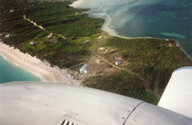
These pics were taken a little over a month after Andrew ran over Eleuthera. Wherever there is no green, the vegetation was killed by huge amounts of wind driven salt spray or direct wave hits.
 

Attachments

  • 92-206.jpg
    92-206.jpg
    87.5 KB · Views: 54
  • 92-207.jpg
    92-207.jpg
    100.9 KB · Views: 53
  • 92-208.jpg
    92-208.jpg
    111 KB · Views: 57
  • 92-209.jpg
    92-209.jpg
    91.7 KB · Views: 56
Last edited:
These pics were taken a little over a month after Andrew ran over Eleuthera. Wherever there is no green, the vegetation was killed by huge amounts of wind driven salt spray or direct wave hits.

Didn't mean to imply no surge, just nothing like predicted, especially when it hit Florida, and low surge for a CAT 4-5 hurricane. Surge for the Bahamas in the two worst places recorded was 16' and 23'. Surge for Biscayne Bay was projected to be 12-16' but was 4-6'. The maximum surge in the US was at Burger King's headquarters 16.9'.

Ultimately most of the US coast had 4-6' though vs. predictions of 12-16' and fears of 20' or more. Katrina had 25-28'. Ike had 15-20'.
 

Latest posts

Back
Top Bottom