Hurricane Joaquin -- just FYI

The friendliest place on the web for anyone who enjoys boating.
If you have answers, please help by responding to the unanswered posts.

Gabe n Em

Guru
Joined
Jan 13, 2015
Messages
580
Location
USA
Vessel Name
Volans
Vessel Make
2001 PDQ MV 32
TS Joaquin

Just a gentle heads up for all you mid -Atlantic boaters:

Tropical Storm JOAQUIN

"Confidence in the details of the track forecast, especially beyond 48 hours, is extremely low" but it's still headed in a direction I'd rather it not go!
 
Here's part of Chris Parker's forecast from this morning.

"In the meantime, interests in Bahamas have little time to prepare: W-NW wind is already established in Bahamas, and will only increase from here. Joaquin should strengthen while drifting toward C Bahamas, and the Islands of Eluthera / Cat / SanSal / Conception / Rum should see worst conditions, with possible 65k Cat1 Hurricane wind, mostly from W-NW in direction, beginning Wed30 night or Thu1. The worse news is this will be a prolonged event, as Joaquin may stall not far from these Islands, with no abatement in conditions until Fri2 or Sat3, when Joaquin is likely to accelerate N away from Bahamas."
 
Peter Ray's info on this new storm:

FORECAST: By the time you read this JOAQUIN will be a Category 1 hurricane. The storm is 90 miles east of Key Largo moving to the SW in very warm waters. It will intensify. Soon it will impact the Bahamas and then on Friday make an abrupt turn North and very rapidly move up the east coast, probably making landfall early next week. From the Carolina northward be prepared for local flooding and heavy rains, heavy seas, rip currents, high surf over the weekend and north of the Carolinas into next week.


DISCUSSION: The path and everything else about JOAQUIN will be clear late Friday. The abrupt turn to the North is due to an approaching frontal system. What is for certain is the strengthening
of JOAQUIN and the northward turn. That interaction will drive the immediate northward turn and accelerate the forward motion. What is not certain is IF and WHERE Joaquin might make landfall. There is a good chance of a land fall either in North Carolina on Sunday or in the NE (around New York) on Tuesday. Again, depending on the configuration of the approaching trough this Friday, this will refine everything.

The middle east coast northward should be thinking about being prepared because things will happen quickly after Friday.
 
Here's this mornings Chris Parkers thoughts.

Based on the current fix, during past 14hr, Joaquin moved 1.0deg S Latitude / 1.1deg W Longitude / pressure fell 18mb. Joaquin's averaged motion is SW (about 230T), about 5k forward pace, and pressure has fallen more than 1mb/hr.

For Bahamas, this fix is troubling...few forecast model with available Vortex center data predict a SW track. I found 4 GFS Ensemble members, plus EGRR & EGRI, as well as possibly UKMet and EURO which correctly anticipate Joaquin's motion this morning.

All of these models (and ONLY these models) bring Joaquin into some part of the South-Central Bahamas from early Thu1 into early Fri2.
Islands at greatest risk for direct hit: SanSal, Conception, Rum, CatIsl.
Islands at some risk for direct hit: LongIsland, GreatExuma, SamanaCay.
A direct hit could bring 80-100k sustained (gusting 95-120k) wind from various directions.
Joaquin's wind field is compact, so Islands avoiding a direct hit probably see only TropicalStorm winds (under 65k sustained).

Other than increasing wind forecast for Islands at risk of taking direct hit, I don't think there are many important changes to Bahamas forecast today.

Folks along US E Coast...we're arriving at a consensus solution for landfall within 120mi of Hatteras (say CpLookout to S Chesapeake) Sat3 afternoon-Sun4, as Cat1-Cat3 (65-100k sustained). More details to follow in a couple hours. Still some risk for landfall N of Mouth of Chesapeake (DelMarVa-SNewEng)...and still some chance Joaquin goes out to sea and fails to make US landfall, but I'm confident enough at this point in a landfall within 120mi of Hatteras to issue a forecast today...
 
..
 

Attachments

  • 114425W5_NL_sm[1].gif
    114425W5_NL_sm[1].gif
    31.7 KB · Views: 130
This is our first year keeping our boat at a marina off the Chesapeake. Am now watching Joaquin with interest. Am headed down to the boat tomorrow to add some extra lines and chafe gear and put out a few more fenders. Other that that is there something that I should be doing ?
 
Looking at the 11 AM discussion at the National Hurricane Center (today, 9/30) it appears to me that they are saying two important things. One, that they do not know right now just exactly what it is going to do, and two, that when things do happen they may happen pretty fast.

So if I had a boat on the East Coast I'd be following the forecast carefully. The NHC updates their info 4 times daily (5 AM, 11 AM, 5 PM, 11 PM) and it is worth checking those.
 
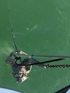
Snagged this 1" galvanized cable last March not far from our current location. With the 123 rule out the window looks like plan c is moving up a slot or 2.ImageUploadedByTrawler Forum1443631268.416636.jpg


Spell check via iPhone.
 
Just read the 5 PM discussion at NHC. Their computer models are disagreeing as to the probable path, so their official forecast is kind of an averaging out of all of them. But the majority now seem to lean toward the Carolinas, and that is what I would be thinking in terms of now if I were up there. Best to err on the side of caution.

"
There is an increased disagreement between the GFS, UKMET, Canadian, and NAVGEM models versus the ECMWF since the last advisory. The ECMWF has continued its forecast of showing a northeastward motion after 72 hours, taking Joaquin just west of Bermuda and out to sea. The other models have all shifted their forecasts to the left and now call for landfall in the Carolinas and the mid-Atlantic states, followed by merger with the baroclinic trough"
 
Last edited:
Just read the 5 PM discussion at NHC. Their computer models are disagreeing as to the probable path, so their official forecast is kind of an averaging out of all of them. But the majority now seem to lean toward the Carolinas, and that is what I would be thinking in terms of now if I were up there. Best to err on the side of caution...

Here's some of Chris Parker's 6pm forecast. More in the morning.

One challenge predicting Joaquin's motion (both Bahamas & possible US E Coast impacts) is very few credible forecast models I've seen predict Joaquin should lie near 24N/73W now. Models which predict the greatest S-component motion in the next 24hrs include EURO, UKMet, NAM, HRRR.

EURO & UKMet bring Joaquin's center into the Bahamas, stalling over-or-near LongIsland Thu1. 18zNAM hi-res seems to suggest Joaquin moves more S and stalls just N of SamanaCay in SE Bahamas. HRRR stalls 20mi N of NAM (40mi N of SamanaCay and 40mi E of SanSal).

So maybe these 4 models have some insights into Joaquin's environment that other models lack.

The long-term forecast problem is there's no agreement among these models' long-term forecasts:
UKMet accelerates Joaquin NNW beginning Thu1 night, with landfall within 30mi of CpLookout midday Sun4.
However the highly reliable hi-res 18zNAM and 12z EURO accelerate Joaquin NNE beginning Thu1 afternoon & late Thu1 night respectively (and eventually out to sea past Bermuda, without any threat to US E Coast).
HRRR seems to cease S-ward motion late tonight, and turns W-then-NW by Thu1 morning, possibly hinting at a track toward US Coast (this is a short-term model for next 15hrs only).
 
A strange storm, this one! Guess we will know more on Friday. I would still put money (although not very much) on the Carolinas, but that is only because over the years, following these things, whenever the computer models widely diverge it seems to usually wind up going more to the left (west) than to the right (east). So we shall see. Thanks for posting that stuff, Larry. Nice to see the various views by the experts.
 
This morning's discussion has it aiming more at LI Sound right now.
So I guess I'll plan on storm prepping as one possible weekend activity. :eek:
 
This is our first year keeping our boat at a marina off the Chesapeake. Am now watching Joaquin with interest. Am headed down to the boat tomorrow to add some extra lines and chafe gear and put out a few more fenders. Other that that is there something that I should be doing ?


Probably strip canvas, cover instruments and tape the cover down, tape seams, maybe dock bumpers to augment your boat fenders, chafe protection on your lines, line snubbers...

Depends slightly on your slip arrangement. Where are you, and what kind of docks? Kind of dock will guide how you deal with major surge... of there is some... and that still depends on Joaquin's real track.

With Isabel in 2003, the track came up on the west side of DC... which put the leading edge right in the middle of the Chesapeake... so we got MAJOR surge.

With Irene in 2011, wasn't too bad; eye came near but that meant the leading edge was well east of us.

With Sandy in 2012, we mostly just had high winds and moderate surge here.

-Chris
 
Peter Ray status report as of this morning (Thursday, October 1st):

"Friends, What a difference 24 hours will make. This major hurricane will weaken before making landfall, but it hasn't quit intensifying yet. I will be having a Game Day forecast tomorrow.


FORECAST: HURRICANE JOAQUIN is on the Bahamas and intensifying and will get to a Category 4 hurricane briefly as it makes it's turn to the north tomorrow. At that point, HURRICANE JOAQUIN will begin to weaken as it moves north. From the North Carolina north there will be beach erosion, rip tides, elevated surf, and flooding up the east coast.


DISCUSSION: The approaching front will abruptly turn HURRICANE JOAQUIN north. But it is how the hurricane will interact with the front that will determine exactly the path it will take. This may not be well established until Friday afternoon or Saturday morning. Confounding this is the forecast track of the best model historically has JOAQUIN's to the east of the other models There is rational for both of these different scenarios. I will be watching the data closely and send out a forecast as soon as it become a bit clear. We may have to wait for the turn north to know how this storm and front are going to interact. This level of uncertainty is rare, but the consequences are great. Given what is there now, I would not discount a landfall, despite what the European model suggest. JOAQUIN should reveal her hand in the next next 24 hours, when the storm turns north. The good news is that after further intensification over the next day, JOAQUIN will be weakening over the weekend and before any landfall."
 
When I started a thread a week or so ago asking how you all prep, this is exactly what I was wondering about. I say it is fascinating but I don't think lightly of your concerns and safety. Take care.
 
I'm leaving tomorrow for 8 days in Central America. I just authorized Herrington Harbour our current marina on the Chesapeake to haul the boat.
 
I've been watching this thing closely. My daughter and her family live in New Bern, NC. Her husband is a Marine, and is supposed to be shipping out on a Med float tomorrow, leaving her alone with her 7 year old daughter. To say she's freaking out a little bit is an understatement :eek:
 
I've been watching this thing closely. My daughter and her family live in New Bern, NC. Her husband is a Marine, and is supposed to be shipping out on a Med float tomorrow, leaving her alone with her 7 year old daughter. To say she's freaking out a little bit is an understatement :eek:

I understand her concern especially with the little one to protect. There are few cellars or basements in that area. How about a shelter? Just being around other people could comfort them. I am sure you have probably thought of this. I certainly hope that they will come through unscathed.
 
Not to down play your daughters fears, but she is thankfully inland a bit, and if anything hop in your car and drive west and find a nice hotel for a night.
And please thank your son-in-law for his service from me, safe return.
I've been watching this thing closely. My daughter and her family live in New Bern, NC. Her husband is a Marine, and is supposed to be shipping out on a Med float tomorrow, leaving her alone with her 7 year old daughter. To say she's freaking out a little bit is an understatement :eek:
 
Not liking the latest target map.
I think I see my boat being the bullseye.


145823W5_NL_sm.gif
 
And one more reminder to all those who talk about hurricanes in South Florida. Another one bypasses South Florida and again the East Coast from SC north is in the potential area. We're going to be 150 miles inland in NC and forecast up to 12" of rain over the weekend.
 
Just heard Joaquin is now a Cat 4. Praying you all stay safe out there.
 
Oh boy, now you did it!!!
And one more reminder to all those who talk about hurricanes in South Florida. Another one bypasses South Florida and again the East Coast from SC north is in the potential area. We're going to be 150 miles inland in NC and forecast up to 12" of rain over the weekend.
 
I hauled out yesterday. Tortuga is in the winter storage shed with all systems winterized. I think she will ride this one out just fine. My haulout was scheduled three weeks ago and had nothing to do with this storm. The marina has already pulled half of the finger piers and the rest will go next week. The season is over for me.
 
I hauled out yesterday. Tortuga is in the winter storage shed with all systems winterized. I think she will ride this one out just fine. My haulout was scheduled three weeks ago and had nothing to do with this storm. The marina has already pulled half of the finger piers and the rest will go next week. The season is over for me.

Hauling out tomorrow. Outside storage. Hopefully our, and our neighbors', jackstands hold should Joaguin hit downeast. The season is over for us as well. :cry:
 

Latest posts

Back
Top Bottom