Any insight on this Chesapeake route?

The friendliest place on the web for anyone who enjoys boating.
If you have answers, please help by responding to the unanswered posts.

evansrr

Veteran Member
Joined
Aug 25, 2013
Messages
54
Location
US
Vessel Name
Little Wing
Vessel Make
Camano 31
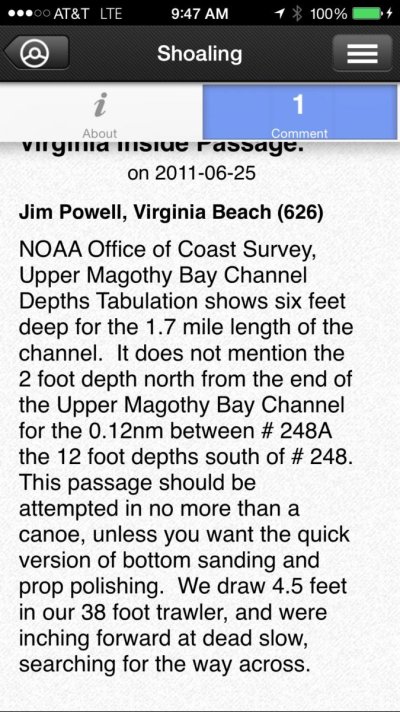
Planning to take my Camano (40" draft) down to the southern Chesapeake area and among other cruises that I'm planning is an interesting looking route that goes under the Bay Bridge Tunnel between Fisherman's island and Cape Charles through a narrow, shallow cut into Magothy Bay and through what appears to be decent width and depth channels through several bays and exiting back to the Atlantic through Cobb Bay. Looks like about 20 miles of isolated area (marsh, swamp?) Have any of you been through this route and lived to tell the tale?
 
I have not been there, but let me offer you a related observation. When you travel long narrow passage from the Bay or the Atlantic it's possible to have significantly greater tidal changes miles inland than what would be normal. Ran into that when going from the Atlantic all the way up to Wachapreague, VA. Local tidal knowledge can be very important.

Ted
 
Why not stay in the established channel, rather than a questionable route under the Bay bridge ? if you had local knowledge it would be one thing, but why take the chance?
 
It actually is an established route all the way according to the chart which show very well defined channel throughout. Very shallow outside the channel however. Just curious if anyone on the forum has made the trip.
 
I have not taken this route nor would I. For one, the survey data on the charts for this area look to be from 1993. Lot's of shoaling at the inlet on the Atlantic side would have me very concerned. Sure the locals run these routes but the scenery (to me) would not justify the risk. If you go, ask some locals and have lot's of bug spray (just saying....)
Slowpoke
 
That's a great idea going to Chesapeake! I was there a year ago with my friend. If you are interested in anything particular, just let me know.
 
Last edited by a moderator:
"Reported LNM Week 15/2014: Shoaling to less than 2.0 feet MLW between Virginia Inside Passage LT 248 (LLNR 6510) and Virginia Inside Passage DBN 250 (LLNR 6525).

Reported LNM Week 15/2013: Shoaling is reported at VIP Light 248 (LLNR 6510) to VIP Daybeacon 250 (LLNR 6525) to a depth of less than 2.0 ft. MLW.

2 foot depths north from the end of the Upper Magothy Bay Channel for 0.12 nm between R248A and R248."
 
Here's some more info on the route I believe you are talking about.
 

Attachments

  • image.jpg
    image.jpg
    159.9 KB · Views: 93
Back
Top Bottom