Back from Queen Charlotte Sound

The friendliest place on the web for anyone who enjoys boating.
If you have answers, please help by responding to the unanswered posts.

nmuir

Senior Member
Joined
Feb 2, 2013
Messages
158
Location
Canada
Vessel Name
Ka Hale Kai
Vessel Make
52' Cheoy Lee
We are back, after having an amazing trip of a few weeks in Hakai / up north, a week Rivers/Smith Inlets, a week in the Broughtons, and 2 weeks in Desolation.

Some have asked about updates. I thought a blog would be a good place to dump all the info / photos with no idea on how much work would be involved! I have created a bit of a monster for myself but will see it though.

As of today I am only up to posting 19 of 42, but feel free to take a look. Please ignore the inevitable typos - I'll clean those up later. The trip logs are there for all legs but no other content past post 19.

The voyages of the Redoubt : Table of Contents

Comments are welcome back here or PM me.

Cheers, Neil
 
P.S. In most cases the points of the specific interest to those heading in the same area - namely detailed anchorage location or routes through difficult passages - can be seen by opening and zooming in on the Google maps (click on the links).

Google Maps is a pretty amazing tool.....
 
Neil,


Reading the blog and just awesome. I am using the same blogger for my blog. Question: I love the Google map that you put at the bottom of each chapter. How did you do this? When I start back up next year I want to do the same.
 
Great Blog thanks so much for sharing!!!
 
Sorry for the slow reply. Works gets in the way!

Here is how I created the maps in google and included them in Blogger. Like anything on a computer there is no doubt dozens of different ways to achieve this. I stumbled across this and it worked so I kept using it.

First of all get your track logs downloaded. I have mine saved as KMZ files though I know there are other GPS formats. For another project I downloaded some free tools to convert between various formats, so it is all doable.

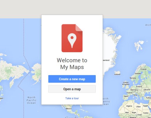
Launch Google Maps and sign in. (You will need a Google account – free).

https://www.google.com/maps/d/

25-08-2015 9-56-29 PM.jpg

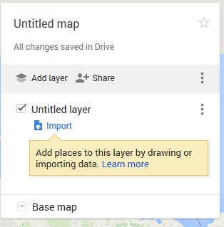
Select Create a new map, then import
On the next window select ‘select a file from your computer’. Select a KMZ file

25-08-2015 9-57-49 PM.jpg

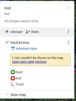
Tune up the presentation to your liking (I use the ‘base map’ option and change to satellite), then select ‘share’

25-08-2015 10-03-12 PM.jpg

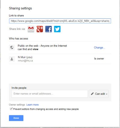
Change the access to public, and copy and paste the ‘link to share’

25-08-2015 10-02-41 PM.jpg

The link can then be included in Blogger post with the 'link' button. Paste the URL in, edit the title text and you are good to go!

There is a lot more that can be done with layers etc but I never found the need to dive deeper.
 
Sorry for the slow reply. Works gets in the way!

Here is how I created the maps in google and included them in Blogger. Like anything on a computer there is no doubt dozens of different ways to achieve this. I stumbled across this and it worked so I kept using it.

First of all get your track logs downloaded. I have mine saved as KMZ files though I know there are other GPS formats. For another project I downloaded some free tools to convert between various formats, so it is all doable.

Launch Google Maps and sign in. (You will need a Google account – free).

https://www.google.com/maps/d/

View attachment 43577

Select Create a new map, then import
On the next window select ‘select a file from your computer’. Select a KMZ file

View attachment 43576

Tune up the presentation to your liking (I use the ‘base map’ option and change to satellite), then select ‘share’

View attachment 43574

Change the access to public, and copy and paste the ‘link to share’

View attachment 43575

The link can then be included in Blogger post with the 'link' button. Paste the URL in, edit the title text and you are good to go!

There is a lot more that can be done with layers etc but I never found the need to dive deeper.

Thank you and fully understand the "work thing" getting in the way..:thumb:
 
Back
Top Bottom