Don't people navigate anymore?

The friendliest place on the web for anyone who enjoys boating.
If you have answers, please help by responding to the unanswered posts.

Tom.B

Moderator Emeritus
Joined
Jul 30, 2009
Messages
5,839
Location
USA
Vessel Name
Skinny Dippin'
Vessel Make
Navigator 4200 Classic
Okay... I haven't started a thread in a long time, but thought I would ask this:

Don't people every pick up a chart and navigate anymore?

As a member of another couple of forums, one of the bigger ones has a rash of morons that ask, "How long does it take to get from (here) to (there)?" which is always followed by some brain surgeon asking, "How fast do you go?" WELL GODDAMMIT PICK UP A CHART AND A DIVIDER COMPASS... MEASURE THE DISTANCE AND FIGURE IT OUT YOU IDIOT!!! I mean really, Yo. :facepalm::confused: Even Google Earth is great for this kinda stuff. Someone called it "The Chartplotter Generation".

Thank you... That will be all for now. Carry on. :smitten:
(P.S.... Get off my lawn!)
 
When we are going somewhere we always run on instruments. We have established courses we follow or if we're going someplace new we put a course into the plotters. Even in perfect visibility we follow the course and have the radar on. Not because we can't find our way around without them, but because it keeps us in practice so when we do encounter fog or poor visibility the transition to really running on instruments is completely seamless. We have never not gone somplace when we wanted to go there because of poor visibility because for us, running in poor visibility is no different than running in good visibility.

When we are planning a trip and want to know how far and how long, we get out the relevant paper charts or chartbook and measure it off. For distance we use a digital scale, one of those things you set the chart scale into and then roll along the course.

We have operated our boat in the PNW this way for the 17 years we've had it.
 
Okay

Don't people every pick up a chart and navigate anymore?

For many the answer is obviously NO!

I crewed on a (new to owner) boat delivery a few yrs back. Owner was obviously proud and conveyed his purported knowledge from his 20+ yrs of sailing.
Broker & I were discussing course options and entering waypoints. The broker mentioned a heading for a leg... I inquired whether he was talking True or Magnetic... which is where the owner jumped in and asked "what's the difference?" :confused:
When I suggested a USPS Piloting course he went on the explain how he relies on chart platters for all his navigation and they take care of it!? :facepalm:

Attitude was obvious - or maybe oblivious - and not worth pursuing any further:banghead:
 
...I inquired whether he was talking True or Magnetic... which is where the owner jumped in and asked "what's the difference?" :confused: ...


Variation. Variation is the difference. :facepalm:
 
My standard horizon chart plotter shows the distance and time to any waypoint I choose, the eta changes if my cruise speed changes. On the rivers I use paper charts to help pick anchorages, but with the Active Captain overlay on garmin charts on my iPad using paper charts is something I seldom do any more. I suspect that people who ask the question of how long are looking for a answer from someone with actual experience is a area they know nothing about.


Sent from my iPad using Trawler Forum
 
On a long trip I take charts but don't use them. Have mostly for backup.

I almost never "plot courses" and rarely know my compass heading. I don't use way points either. I don't travel in a straight line. We have no AP.

I use the GPS on a fairly close setting for what's just ahead of the boat. I use this i- pad plugged into a DC automotive receptacle so I can surf ahead (via Navamatics) 5 miles or 55 miles. Alternative anchorages are almost constantly being looked at both near and far. And for logistics or just for fun.

We also use cruising guides.
 
I used to communicate with other vessels using Morse Code. Now I just use emoticons.
 
"I used to communicate with other vessels using Morse Code. Now I just use emoticons.":rofl::rofl::rofl::thumb:

Al-Ketchikan
 
"Vote" is the difference if you are going backwards.
 
When the GPS is knocked out with an EMP , most folks will probably go to the first marina they see and rent a slip for 2- 3 years.
 
When I am in open water/no fixed landmark to aim at, I make a note of my compass heading in case the gps/computer goes down. Paper chart for the area is always on the helm as the chartplotter/computer doesn't give the me the overview picture.
 
Fact - at times paper charts will show bottom features that are a serious hazard at sea i.e., pinnacles, that will be missed on a chart plotter. Keep the paper & compare it with the plotter.
 
When the GPS is knocked out with an EMP , most folks will probably go to the first marina they see and rent a slip for 2- 3 years.

Are you serious?
W. Al.jpg
 
In shallow ICW and most of FL marks are moved frequently and conditions change a lot. Charts and GPS maps are often wrong so setting waypoints unless offshore is not a good idea.

On the west coast things don't change much.
 
Capt. Vancouver made it with no charts, plotters or engines. Capt. Cook did ok too, until he was eaten by the Hawaiins. TB, marketing now rules navigation don't you think?
 
Capt. Vancouver made it with no charts, plotters or engines. Capt. Cook did ok too, until he was eaten by the Hawaiins. TB, marketing now rules navigation don't you think?

If you want to do it like Cook and Vancouver all you have to do is anchor the big boat offshore and launch a few guys in a rowboat with a leadline to find out where the rocks are. Make sure you have enough small boats and crew to tow the big one if you want to do it without an engine.

If Cook and Vancouver had a chartplotter and a GPS they probably would have been delighted to use them and not for one moment consider themselves less than competent seafarers. Where do you think most of the chart data in use today originated? It was guys rowing a little whaleboat taking soundings while triangulating their position.

I think technology now rules navigation but anyone is free to use a rowboat and a leadline if it makes them feel better. Marketing is how the best available technology is sold to those who don't want to carry lots of rowboats, surveyors, and cartographers.
 
Really, if someone asks that question - not even realizing that D=V*T - then is there any point in expecting intelligent behavior? Maybe it's best to not engage and let these potential Darwin awards fulfill their destiny.
 
If you want to do it like Cook and Vancouver all you have to do is anchor the big boat offshore and launch a few guys in a rowboat with a leadline to find out where the rocks are. Make sure you have enough small boats and crew to tow the big one if you want to do it without an engine.

If Cook and Vancouver had a chartplotter and a GPS they probably would have been delighted to use them and not for one moment consider themselves less than competent seafarers. Where do you think most of the chart data in use today originated? It was guys rowing a little whaleboat taking soundings while triangulating their position.

I think technology now rules navigation but anyone is free to use a rowboat and a leadline if it makes them feel better. Marketing is how the best available technology is sold to those who don't want to carry lots of rowboats, surveyors, and cartographers.
:thumb:...it would be interesting to know the percentages of navigational errors from then to now.

Being able to save your butt in the one in a million total electronic failure is good but knowing how to get your engine running is probably more important than celestial to most of us.

I still say coastal piloting without electronic in limited visibility is not easy for the feint of heart....I'm pretty good at it...but not having a crew to help with constant speed checking and lookouts while I crunch numbers and plot...would get pretty cheek puckering.

Broad daylight and decent vis shouldn't be much of a challenge...but when it's not...the first safe place to anchor is probably the best idea.

Raster charts are the same as paper charts so whether spread out on a table or on a screen I don't see much of a diff in nav.


But back to the OP...it is inconceivable to me to be planning a voyage and ask for the distance and even worse, the time it takes to get places. For the time you have to know your SOG and even that is a guess for long distance travel....pretty scary who is driving boats out there.
 
Last edited:
Marketing is how the best available technology is sold to those who don't want to carry lots of rowboats, surveyors, and cartographers.

Absolutely correct. I have 3 different charting systems (not counting the IPad) and use them all.

Vancouver had the best measuring, surveying and time keeping devices of his time. They felt their equipment quite up-to-date, rightfully so. Some of us started surveying and navigating with an Ephemerus, not sure I can spell it anymore.
 
Don't people every pick up a chart and navigate anymore?

)

Your implication is that one must "pick up a paper chart" to "navigate." Well, we do just fine navigating, using various types of software, planning trips, always knowing the answers to the questions you pose. We enlarge the charts to see any amount of detail we need. We occasionally will print out a page or two for one reason or another. We didn't start out on paper charts like most of you. We know fully how to use them but don't need to do so. We don't trust any one method for safely navigating but do double check with other tools.

Oh, we also use electricity rather than wood burning stoves, even use microwaves. We use electric lights rather than candles to read at night. We now use LED bulbs. We use computers and tablets and smartphones.

We also don't buy newspapers, but read them online.

But don't imply that those who don't do it your way, don't do it.

As to someone asking distances and times, they have always and will always do so rather than figuring it out themselves. I might note that they do that on land too. People ask how far or how long a drive is all the time when they could just pull up a map online.
 
EMP? No problem.

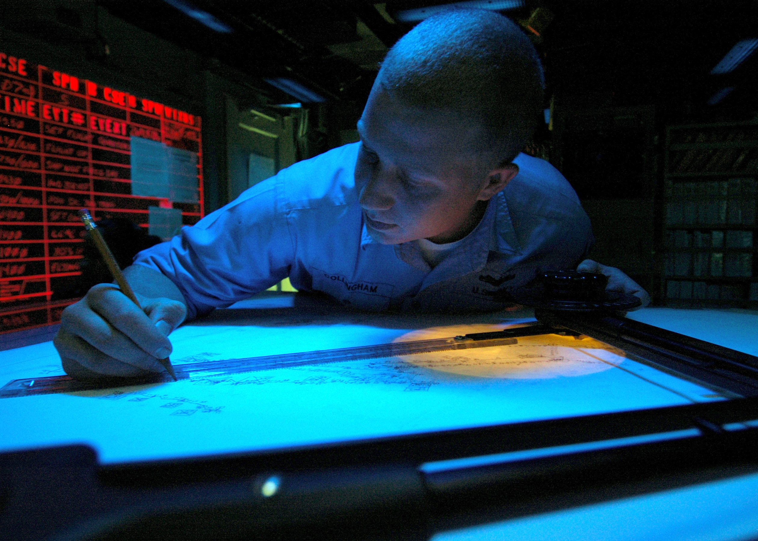
Does anyone remember what this is and what it does? Or even better, how to use it?

Tracer.jpg
 
Raster charts are the same as paper charts so whether spread out on a table or on a screen I don't see much of a diff in nav.
:thumb:
 
Your implication is that one must "pick up a paper chart" to "navigate." Well, we do just fine navigating, using various types of software, planning trips, always knowing the answers to the questions you pose. We enlarge the charts to see any amount of detail we need. We occasionally will print out a page or two for one reason or another. We didn't start out on paper charts like most of you. We know fully how to use them but don't need to do so. We don't trust any one method for safely navigating but do double check with other tools.

Oh, we also use electricity rather than wood burning stoves, even use microwaves. We use electric lights rather than candles to read at night. We now use LED bulbs. We use computers and tablets and smartphones.

We also don't buy newspapers, but read them online.

But don't imply that those who don't do it your way, don't do it.

As to someone asking distances and times, they have always and will always do so rather than figuring it out themselves. I might note that they do that on land too. People ask how far or how long a drive is all the time when they could just pull up a map online.

Not sure I see where I specifically said paper, but you can be that way if you like. I may have implied it because you can't use a divider compass on a plotter, but the point you missed was... oh nevermind.
 
Not sure I see where I specifically said paper, but you can be that way if you like. I may have implied it because you can't use a divider compass on a plotter, but the point you missed was... oh nevermind.

Maybe I erroneously inferred it from "pick up a chart and navigate" and "WELL GODDAMMIT PICK UP A CHART AND A DIVIDER COMPASS... MEASURE THE DISTANCE AND FIGURE IT OUT YOU IDIOT!!!". I do believe a couple of others did the same.

If your point is gaining knowledge and experience in using various tools and methods to plan and navigate then I totally agree. I'm not bothered by those who use technology or methods different than what I use, but those who are ill prepared for the cruising they undertake.
 
Please enlighten us. It's probably more effective than my tinfoil hat.

It is a DRT (Dead Reckoning Tracer) which was a large metal cabinet with a glass top. Under the glass top was a movable carriage and light attached to worm gears that controlled movement along the X and Y axis. It was normally covered with a chart or a piece of tracing paper. The DRT was coupled to the ships gyro and pitometer log (speedometer/distance log). As the ship moved, a light was projected upward which illuminated the chart or paper with a bright spot or 'bug'.

The moving bug provided an instantaneously updated DR position. The operator of the DRT merely plotted the position of the bug, noting the time on the chart plot. This provided a graphic representation of the ship's position. Corrections for actual fixes from other sources, set, drift and other factors were applied to enhance the accuracy of the plot and the resulting DR position.

Properly used and corrected, they were capable of producing quite accurate DR position information.

Remember, this was developed back in the days before GPS and satellite-based navigation systems. Weather could obscure the sky and you could go without a celestial fix for days. This DR plot could sometimes be very important.

US_Navy_060826-N-6403R-014_Operations_Specialist_2nd_Class_Christopher_Collingham_from_Boise,_Idaho,_stands_the_Digital_Dead_Reckoning_Tracer_(DDRT)_watch_in_the_Combat_Information_Center_(CIC)_aboard_the_amphibious_assault_shi.jpg

Very cool. Perhaps the beginning of electronic navigation?
 

Latest posts

Back
Top Bottom