Clearwater to Carabelle, then Panama City or Pensacola

The friendliest place on the web for anyone who enjoys boating.
If you have answers, please help by responding to the unanswered posts.

cardude01

Guru
Joined
Nov 26, 2012
Messages
5,290
Location
USA
Vessel Name
Bijou
Vessel Make
2008 Island Packet PY/SP
Trying to arrange to get the boat from Clearwater to Carabelle, then over to Panama City and beyond. I have a buddy who wants to do the Gulf crossing to Carabelle with me, but because we are flying over from Texas the scheduling and weather is up in the air.

Questions:

I have contacted Chris Parker to see if he can do one of his detailed three day forecasts for me starting the day before my flight so I can cancel the flight if the weather doesn't cooperate. Does that sound like a reasonable approach? I used him for my Keys To Marco crossing and it worked out well.

Is the ICW run from Carabelle to Panama City interesting? Looks like about 75 miles so looks to be doable in one long day.

I will lose my buddy at Panama City-- he has to fly home and get back to work. At what point on this trip back to Texas will I not be able to run solo safely. Loisuana?

What would be a trip length estimation from Panama City to Clear Lake if I can make 70 miles per day?

For some reason I get really bogged down when I start reviewing the Louisiana part of the ICW.
Is it difficult or am I just being a wuss?
 
Last edited:
Dude, Carabelle to Panama City is easy. Pretty straight forward until you go under the first bridge at Panama City. No real problem, but watch for the bouy color change there and back again at the pass.

I have run the ICW into Lake Ponlchartrain with no real problems, but no further.
 
The ICW run across Louisiana is no problemo! The main hassle is locking across the Miss river as it can get busy and quite a wait.
 
Dude, for weather, send an email to mailto:marvboater@aol.com and ask to be put on his daily mailing list. His forecasts are free and spot on (in my experience).


Include Boat name, your name as captain, hailing port and size. He will send a confirmation within an hour or two. His report will include weather for both sides (as separate reports). One for Clearwater and one for Carabelle. I did this trip 2 months ago so ask any questions you need to. Plan on arriving on the East side of N.O on a Friday or Saturday as locking across is much easier when their are no bridge/lock curfews. We crossed straight to Pensacola and then to Lulu's to Gulfport to N.O. PM me if you need anything. Our Houma Ambassador, Steve, has abandoned his post otherwise I would strongly recommend you meet him when arriving there. If the Crossing from East N.O to Houma is bothering you, I might be able to drive down and do it with you. On a weekend and with an early start it should be doable (if the lock Gods cooperate) in one day.


Excellent. Thanks. I will let you know when I get closer to Nola.

Didn't your wife do that trip with you? Through the locks?
 
Moonstruck, Rardoin,

Thanks for the info.

The ICW from Carabelle looks swampy and interesting on the map.

The Mississippi River was one of the sections I was wondering about.
 
For a very short way you will get a marker color change approaching Pensacola Pass. It is a wide ship channel there, so should not present a problem. Just watch the gold triangles and squares.
 
For a very short way you will get a marker color change approaching Pensacola Pass. It is a wide ship channel there, so should not present a problem. Just watch the gold triangles and squares.


Gold? Don't remember ever seeing gold. Is that for shipping channels?
 
Gold? Don't remember ever seeing gold. Is that for shipping channels?

Dude, I thought you knew. All ICW markers are marked with a gold triangle (starboard side going toward Brownsville, TX} That generally corresponds with the red markers. Gold square on the port markers which are generally green. When you get to a pass with a from sea channel like Cape Fear River the markers colors will reverse and the Gold Triangle will be on the green. That means treat the green like a red, and visa versa. So keep an eye on the gold.
 
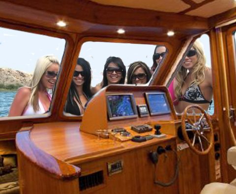
Bill: You gotta take Don's words with a grain of salt, even when his information is correct (in this case, it is). The guy usually knows what he's talking about, but since the view in front of the helm is typically like this (photo), he often gets distracted when the colors switch sides.
 

Attachments

  • through Dons windshield.jpg
    through Dons windshield.jpg
    105.8 KB · Views: 107
Excellent. Thanks. I will let you know when I get closer to Nola.

Didn't your wife do that trip with you? Through the locks?

Yes sir, Michelle and I, which is why I said if you were going through alone I would try get down and help as it sure makes it a lot easier
 
Bill: You gotta take Don's words with a grain of salt, even when his information is correct (in this case, it is). The guy usually knows what he's talking about, but since the view in front of the helm is typically like this (photo), he often gets distracted when the colors switch sides.


Damn. Nice helm. ?
 
Yes sir, Michelle and I, which is why I said if you were going through alone I would try get down and help as it sure makes it a lot easier


Ok. If I can't talk my wife into helping me I will do that. Thanks.

Is there a marina you stayed at in Houma?
 
Dude, I thought you knew. All ICW markers are marked with a gold triangle (starboard side going toward Brownsville, TX} That generally corresponds with the red markers. Gold square on the port markers which are generally green. When you get to a pass with a from sea channel like Cape Fear River the markers colors will reverse and the Gold Triangle will be on the green. That means treat the green like a red, and visa versa. So keep an eye on the gold.


Don, I'm reminded daily how little I know about this boating deal. I'm having fun learning though!
 
Yes the Houma municipal marina. As you come into Houma you will see two parallel overhead bridges, about 100 feet apart. The marina is just a canal to your starboard and is between the two bridges. Blink and you will miss it lol. $25.00/night
 
Bill: You gotta take Don's words with a grain of salt, even when his information is correct (in this case, it is). The guy usually knows what he's talking about, but since the view in front of the helm is typically like this (photo), he often gets distracted when the colors switch sides.

Larry, that's my excuse when running aground. What's yours?

By the way, when I run aground we just party until high tide. Kinda eases the pain.
 
By the way, when I run aground we just party until high tide. Kinda eases the pain.

Sucks the next day when you wake up and realize you grounded on the highest tide of the month! :banghead:
 
Bill: You gotta take Don's words with a grain of salt, even when his information is correct (in this case, it is). The guy usually knows what he's talking about, but since the view in front of the helm is typically like this (photo), he often gets distracted when the colors switch sides.

 
Larry, that's my excuse when running aground. What's yours?

Mine is the massive bulk of my trawler yacht displacement and its intimidating, however consequential, masculine draft.
 
I have to admit that sometimes I'm side tracked by the girls. They are just Simply Irresistable.

 
From Carabelle to Panama City, do most people take the inland ICW route or go outside if weather is nice.

The ICW route looks kind of interesting-- looks like you go through some swamps.

Are the shoals on the outside a big issue?
 
I have ususally done this the ICW inside route. Easy route and a fair amount of marinas. You can usually go this way in most weather conditions and has some nice things to look at. Also the shortest route. Can make it in a good day. After that you can jump outside at Panama City and run to Destin or Pensacola outside dependent on weather and what you want to do. The inland route is great though. Take it at what ever pace you want to.
 
As far as the shoals on the outside I have always avoided going anywhere close to the shore if I go outside between Carabelle and Panama City. I have never ventured in to find out but what is on the charts is enough to keep me out of that area. Panama city to Destin and Pensacola no issue though.
 
Ok. Thanks. I like the inside route idea. Want some scenery.
 
If you happen to anchor in Saul Creek a little past Appachicola let me know how it is. You can see the reviews on Active Captain. Looks interesting and I always wanted to stop there but never had the time.
 
Ditto what Rogerh wrote above (about shoaly places along the stretch around Cape San Blas. The inside route is beautiful and interesting. Appalachicola is always worth a stop. From there, you run short way up the river, then hook a left to follow the ICW. Lake Wimico is a good example of what a lot of the Florida panhandle must have once looked like.

From the lake to East Bay (of St. Andrews Bay) it's mostly a dredged-out ditch. Shoals form on the insides of bends. If you draw four or more, watch your fatho and favor the outside of turns.

An alternative, just past White City heading westbound, is to run down the Gulf County Canal (straight as a rifle shot), come out at the old lumber port town of Port St. Joe, and head west in the Gulf from there. But, paralleling the coast along there the swells come mostly on the beam, so unless you really enjoy rocking and rolling, it can soon get old.
 
An alternative, just past White City heading westbound, is to run down the Gulf County Canal (straight as a rifle shot), come out at the old lumber port town of Port St. Joe, and head west in the Gulf from there. But, paralleling the coast along there the swells come mostly on the beam, so unless you really enjoy rocking and rolling, it can soon get old.

This is a great suggestion. Anchor in St. Joseph bay for a day or two and go scalloping! St. Joe's marina is a very nice stop over if you prefer docks..
 
Last edited:
If you happen to anchor in Saul Creek a little past Appachicola let me know how it is. You can see the reviews on Active Captain. Looks interesting and I always wanted to stop there but never had the time.


Will do. Thanks.
 
Ditto what Rogerh wrote above (about shoaly places along the stretch around Cape San Blas. The inside route is beautiful and interesting. Appalachicola is always worth a stop. From there, you run short way up the river, then hook a left to follow the ICW. Lake Wimico is a good example of what a lot of the Florida panhandle must have once looked like.

From the lake to East Bay (of St. Andrews Bay) it's mostly a dredged-out ditch. Shoals form on the insides of bends. If you draw four or more, watch your fatho and favor the outside of turns.

An alternative, just past White City heading westbound, is to run down the Gulf County Canal (straight as a rifle shot), come out at the old lumber port town of Port St. Joe, and head west in the Gulf from there. But, paralleling the coast along there the swells come mostly on the beam, so unless you really enjoy rocking and rolling, it can soon get old.


Will definitely stop for some oysters at Appalachicola.

Thanks for all the great details.
 
But, paralleling the coast along there the swells come mostly on the beam, so unless you really enjoy rocking and rolling, it can soon get old.

No problem with rocking and rolling. I heard it was one of Cardude's favorite things to do on trip to Key West!:hide:
 
Back
Top Bottom