Key West trip

The friendliest place on the web for anyone who enjoys boating.
If you have answers, please help by responding to the unanswered posts.

cardude01

Guru
Joined
Nov 26, 2012
Messages
5,290
Location
USA
Vessel Name
Bijou
Vessel Make
2008 Island Packet PY/SP
ImageUploadedByTrawler Forum1428856611.065334.jpg

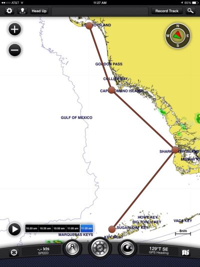
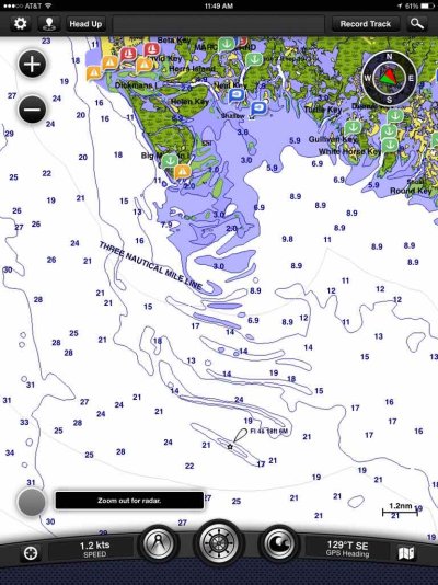
Sitting here playing with my Garmin Blue Cart app on the iPad, thinking about our upcoming Key West trip in June. I've only cruised the ICW on this boat so far, so I need some advice for the three days I've roughly planned on the outside. I've planned for three days to keep the hours actually cruising to 7 hours or less since the entire family will be aboard-- I found out 10 hours of cruising makes for a very long day, and that was not a full boat. Also, I want to hug the coast and not shoot straight across on this maiden voyage on the outside, for safety and for scenery. On the way back maybe we shoot straight across from Key West to Marco Island, which looks to be about a 10-11 hour run at 7 knots. Still not sure about that.

My questions are, so far:

1. What will be the most likely wind direction be during June? From a site called "weatherspark" it looks like E and NE winds about 37% of June, which I assume I want, and W and SW winds about 16% of June which would give me a beam sea, which I don't want in my boat (round bottom and rolly). Do these wind directions sound about right? If there is a west component in the wind I can tack into it and that reduces the roll quite a bit, but it would be nice to not have to do that

2. Is there a certain distance/depth I should stay offshore to stay out of crab traps, calmer waters, safety, etc?

3. The area just south of Marco Island looks interesting (Cape Romano Shoals). Should I stay deep and go around all this or try to cut through?
ImageUploadedByTrawler Forum1428857508.835108.jpg

4. Was planning on a stop at Shark River to anchor for the night. Anything special I should plan for, other than swarms of mosquitos?

5. After Shark River do I cut across to Key West or is some other route advisable?

Thanks!
 
I found the charts accurate around Cape Romano. Use due diligence and pick your way around.

Choose your most direct route and don't worry. Crap pots are out there but just keep an eye out. Shark River to Marathon then Key West is an easy route. Hawk channel is the deeper, safer, easier route so passing by Marathon to Key West makes sense.

You'll see lots of boats, don't worry.
 
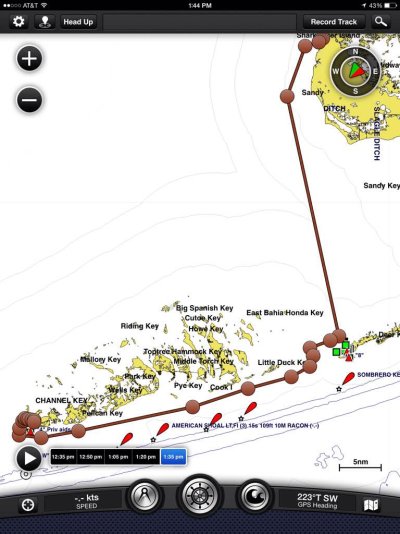
So go this route (84nm)
ImageUploadedByTrawler Forum1428864380.685895.jpg

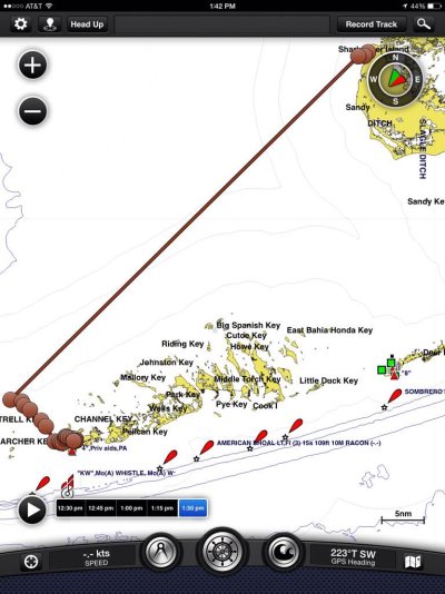
Instead of this one (70nm)
ImageUploadedByTrawler Forum1428864401.967661.jpg

I can see now that I will have to break either of these routes into two days (stop on Marathon I guess), so the easier route is the one I'm interested in.
 
I measure about 91 NM from Factory Bay in Marco to Key West Bight direct. But this is the way I would go. Kick it up to 8 kts and do it in about 12 hours, all daylight.

David
 
I strongly disagree with relying on the charts to cut through Cape Romano shoals, especially the northern half, just because someone else got lucky doesn't mean you will.

Unless you have an interest in cruising from Marathon to KW I don't see the point of the detour; if you do there are a few nice anchoring opportunities with attendant dinghy exploration (Bahia Honda and Newfound Harbor come to mind off hand), or a side trip out to one of the great diving and snorkeling spots like Looe Key from either.

Shark River is beautiful, great dinghy exploration and coming or going a respite from the urban craziness of KW. Personally, we liked the times when we'd just gunk hole along Cape Sable and the 10,000 Islands. Much more interesting to the crew than hours of blue water cruising. Of course, that's just personal preference. Otherwise I'd rather drive to KW unless I am on the way to somewhere else.

It will be hot in June, and on the cusp of the bad bugginess which seems to vary from year to year.

I would encourage you not to have a strict schedule for this trip and pick a weather window. The Gulf can be like a bathtub or nasty. We used to charter in that area in June and had some great times with a lot of nice spots to ourselves. Actually, we'd see very few boats that time of year. The snow birds are gone and the locals are off to the Bahamas. No question the weather is nicer in the late winter, early spring which is when we went there in our Hatteras.
 
We go direct from Marco to Key West about 100 miles. Sometimes direct from San Carlos Bay. About 120 miles. The distance to Marathon is about the same. If you are going to Key West, direct is best.

Prevailing winds in June should be easterly.
 
So go this route (84nm)
View attachment 39121

Instead of this one (70nm)
View attachment 39122

I can see now that I will have to break either of these routes into two days (stop on Marathon I guess), so the easier route is the one I'm interested in.

I recommend this route via Marathon, we did this route a few years ago and it was a great trip. However weather and fuel capacity need to be your key.

Weather can get tough on the straight route, I have been on the Key West Ferry a few times from Marco and even in nice weather that area can stand up.
 
In June, the weather is pretty predictable. It should be calm in the morning and the wind will build throughout the day. Thunderstorms will form over Florida Bay in the afternoon but you should be well past them by then. The summertime weather time pattern is very predictable in South Florida.

The Marathon stopover will cost you a day. The turn into Big Spanish Channel and the detour to Marathon will only be a few hours short over going straight into Key West.

If you are planning on staying at a marina in Key West Harbor, when you get to Key West via the Gulf side your marina will be right there. If you're going to stay at Stock Island, it will be a couple hours more to travel around. This will be just the opposite if you opted for the Marathon route because the Stock Island marina's are just off Hawks Channel.

You are right to be aware of the mosquitos, but be advised they are much worse that you can even imagine in places like shark river in June.

Regardless of which route you take, start at zero dark thirty and make as much time as you can in the morning hours.

Enjoy, :socool:
 
Thanks for all the comments everyone. I need to sit and cogitate for a spell now. ?
 
Folks are correct about the time and distance from Marco to Key West or Marathon. They are the same. Little Shark River can have enough bugs this time of year that you will wish you took a pass on anchoring there. Best advise to get to Key West is a straight line from Marco. At Marco, anchor opposite the Snook Inn restaurant and up stream 100 yards. Factory bay is too muddy and takes too much time to clean your anchor chain. Make sure you save your track on your chart plotter when you go into Marco so you can follow it on the way out the next morning. Leave Marco just as the light is bright enough to see the markers. Keep in mind the current flow in the Marco River. With the right weather window your trip will be exciting, fun and a day well spent. There are going to be crab balls, so keep an eye out. But you will have far fewer going to Key West than you would have going to Marathon. With a straight line plotted from Marco to the Green Bell Buoy #1 there are no obstacles in your path. After passing #1 just keep an eye on the East and West submerged jetties marking the entrance to the North Channel. The anchor balls at Garrison Bight are spaced well and are cheap, with an easy run to the Key West harbor. A $5.00 per day dinghy permit ties you up in front of the Turtle Crawl Bar. As with any passage, always have a fins and snorkel on board just in case you get a line in your prop. Fifteen minutes over the side beats a four hour wait for one of the tow services.
 
So no issues trying to navigate into the Bight at around 7-8pm? It looks pretty straightforward on the chart.

I'm starting to lean towards this route, weather permitting.
 
Either route will get you there. If you decide to go the Marathon route you will be in sight of land almost all the way but you will dodge crab pots which I didn't find to be a problem. From Marco I went to Indian Key then on to Marathon. Anchoring just inside Indian Key will give you a good breeze to help mitigate the bug problem, but you'll still get some. I've never done Shark River as there is no place to take the dog ashore. 70 miles from Indian Key to Marathon.
From Marathon most folks take the Hawk Channel route, about 45 miles to key West - deep water, no issues and more scenic. Again I found the charts accurate around Cape Romano and had no problem.

I've also gone straight from Key West to Marco about 90 miles. The channel leading to KW is easy to navigate.

I've never done either route when weather was pending. I'm a chicken when it comes to weather.
 
Nothing chicken about waiting for good weather windows, that's smart captaining.

That is Sooo true. I have had many people ask the best way to handle a boat in rough seas. I tell them most seasoned, experienced captains find that not lifting the anchor works best!
 
So no issues trying to navigate into the Bight at around 7-8pm? It looks pretty straightforward on the chart.

I'm starting to lean towards this route, weather permitting.

I don't like going into new places in the dark, for the first time. So the best course of action is leave Marco as soon as you feel comfortable at first light so you make it to Key West with some day light left.
 
Key West Bight is an easy shot coming in from NW channel in the dark.....getting in to NW channel safely is the issue. If you have radar you should be ok in small seas but if the seas kick up and your channel marker returns are not steady the mostly submerged jetties are there to make it a bad night if you get it wrong. If you have never run it at night (even with radar) it can be a high sphincter factor IME. After your first time it is no big deal (kinda like many other things in life..LOL)
 
Key West Bight is an easy shot coming in from NW channel in the dark.....getting in to NW channel safely is the issue. If you have radar you should be ok in small seas but if the seas kick up and your channel marker returns are not steady the mostly submerged jetties are there to make it a bad night if you get it wrong. If you have never run it at night (even with radar) it can be a high sphincter factor IME. After your first time it is no big deal (kinda like many other things in life..LOL)

I don't want to do it at night. Figured if I got there before 8pm I would still have some light left, but now I realize I missed the time difference between Texas and FL. :hide:
 
Leaving Marco before daylight, and running 7 knots should get you to KW with plenty of daylight in June.
 
Again, the mosquito issue is on the cusp in June, especially early June. I'd call the folks at the Rod and Gun Club in Everglades City and at the ranger station in Flamingo to see how they are. One early June, we had a beautiful stay in Shark River. I don't know, going straight to KW from Marco and missing some beautiful cruising grounds seems like a shame to me. Might as well take the ferry, IMO. Different strokes for different folks I guess.
 
Again, the mosquito issue is on the cusp in June, especially early June. I'd call the folks at the Rod and Gun Club in Everglades City and at the ranger station in Flamingo to see how they are. One early June, we had a beautiful stay in Shark River. I don't know, going straight to KW from Marco and missing some beautiful cruising grounds seems like a shame to me. Might as well take the ferry, IMO. Different strokes for different folks I guess.


Good idea. I'll call them.
 
The mosquito problem is related to the weather and more specifically to rain. The Florida monsoons normally start in late May or June. One year they didn't start until July and there were many wildfires in the state. There is a lot of humid weather and rain this week so the mosquito's may come out early. Best thing is to watch the weather patterns. When the afternoon showers start, the mosquito eggs will be hatching.
 
I agree with rardoin, forget first light and watch the sun rise with a few hours under your belt, makes your chance of getting in with enough light to keep the pucker factor low much better.

:socool:

Leaving Marco before daylight, and running 7 knots should get you to KW with plenty of daylight in June.
 
Nothing chicken about waiting for good weather windows, that's smart captaining.

Yes and if you want some professional help at a reasonable cost, contact Chris Parker. He is currently the "go to" guy for weather forecasting for the area. He can give you detailed weather for your route, for a day, week or your entire trip if you want.

https://www.mwxc.com/index.php
 
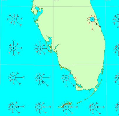
Here's the wind for June.

Which website or product produces these wind prediction percentages? I've seen this in books but haven't seen a website that gives them. It's the perfect thing for a lot of things I'm playing with now.
 
Pilot Charts. Google it, you can download them for free. Great tool.
 
Yes and if you want some professional help at a reasonable cost, contact Chris Parker. He is currently the "go to" guy for weather forecasting for the area. He can give you detailed weather for your route, for a day, week or your entire trip if you want.

https://www.mwxc.com/index.php


Chris Parker's service is good. Although I use Commanders' Weather routing service these days. Commanders' Weather

But for a simple trip like that you could just use Passage Weather and one or two of the many marine weather apps available.

I like PocketGrip, WeatherMap + and any one of the several real time weather radar apps.

Bouy Weather is great too.
 
Back
Top Bottom