Coastal Explorer and the Bahamas

The friendliest place on the web for anyone who enjoys boating.
If you have answers, please help by responding to the unanswered posts.

Ski in NC

Technical Guru
Joined
Jan 18, 2014
Messages
6,194
Location
USA
Vessel Name
Louisa
Vessel Make
Custom Built 38
Hi all. Computer idiot needs some advice.

Have an old HP labtop running vista and Coastal Explorer.

The combo works great. Ran down here to the Keys with no computer issues at all.

I may be heading to the Bahamas next week, weather dependent of course.

I bought the Explorer near-Bahamas chart book. Looks like pretty good stuff. The computer has some very large scale Bahamas charts loaded, but not very good for nav. I'm comfortable using the paper charts plus the computer, but would like to improve computer charts.

I understand there are digital version of the Explorer charts, but as I search for them it seems there are in c-map or other chip versions for dedicated marine plotters.

How can I get digital versions of Explorer charts for my CE laptop? Any way to do this on line? Or do I need to order a CD and load it that way?

Remember I'm a computer idiot. If this requires any degree of IT intelligence, I will fail and then smash my mouse.

Mouse requests any help possible.

Thanks,

Eric
 
Eric:

If you have an iPad or an Android tablet like a Nexus there is a cheap way to get quality Bahamas charts. Download the "free" Plan2Nav app from the Apple store or the Android Play store depending on which type tablet you have.

Then download the $20 US east coast chart package (which is why I put the free in quotes. It won't give details without the $20 chart package). Plan2Nav is the Jeppesen navigation app for tablets. Their Bahamas charts look pretty good, but be aware of geo referencing errors in the Bahamas (the chart feature can be indicated far off from its real location).

AFAIK there is nothing cheap that covers the Bahamas for the PC like the Plan2Nav app for tablets.

David
 
When we went to the Bahamas I bought the C-map charts for the region from Rose Point for Coastal Explorer. I don't recall the cost, but probably $200. Cheap insurance, and less than a night or few in a marina. I found them to be quite accurate.

In CE, click the menu icon then pick Chart Catalog. There is a tab for the Chart Store. That should get you going without harming any mice in the process. Definitely do it all while you have a good internet connection.
 
Thanks guys. I just bought the cmap for SE USA and Bahamas. I was able to load it just fine. 200 bucks.

The one question I have is that it stated it included Explorer charts, but it does not appear the same as the Explorer chart book charts. Have I been had? Or are they in there but digitized into something that appears different?

Either way it looks plenty good for me to nav with.

Mouse is intact.
 
I think the c-map charts are all vector charts. I know mine were, but don't recall if there was a choice. And the printed chart books will be raster charts. So they look different, but the vector chart has all the same info plus more. For example, I remember the c-map chart showing more routes than the Explorer charts alone.

Your mouse gets to live another day....
 
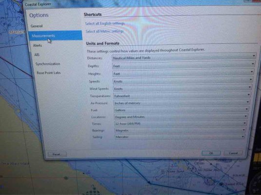
One strange thing I noticed is when playing with the c-map charts in CE, when you zoom in to say Hope Town, the depth readings all seem to go to zero. It's in fathoms, but I know it is not all zero.

Can you change to meters or feet? For shallows a fathom is a rather coarse measure.
 
One strange thing I noticed is when playing with the c-map charts in CE, when you zoom in to say Hope Town, the depth readings all seem to go to zero. It's in fathoms, but I know it is not all zero.

Can you change to meters or feet? For shallows a fathom is a rather coarse measure.


Yes. It's under options in the drop down menu.
ImageUploadedByTrawler Forum1428104071.684425.jpg
 
ImageUploadedByTrawler Forum1428104137.799372.jpg
Here's Hopetown in feet.
 
Ha! It worked. Now in feet. Soundings look sensible. Mine looks just like your screenshot.

Mouse is breathing easy!!

Thanks.
 
Slight hijack warning.
I run CE as well and use the free NOAA vector charts. What's the difference between these and Cmap ? Is it worth the $ to actually purchase them?
I run Cmap on my CC MFD.

Sent from my Nexus 4 using Trawler
 
In US waters I don't think there is much advantage to c-Map, though it does give a different view of things, and sometimes having two sources of data is useful. But I expect the US c-map charts are all based off the NOAA data, so it's unclear whether they really are giving a second opinion, or just repeating what the other guy said...

Outside the US is where they are most useful. I have heard there are some areas where Navionics has more accurate coverage than C-Map, but so far in the areas where I have been, c-map has been good, and in the Canadian Maritimes, I had both and much preferred c-map. For the Bahamas it seems universal that you want something derived from the Explorer charts. The c-map charts are just that.
 
Thanks.. Since you just completed your conversion to CE. Are you running NOAA in the US waters ?

Sent from my Nexus 4 using Trawler
 
Yes, I am. I have c-map for some large chunk of the west coast. I don't recall exactly how much, since my focus in buying it was to get BC. But in US waters I generally use the NOAA vector charts, and occasionally switch to the Raster charts. I think it's partly personal preference, and partly habit since we all tend to like what we get used to.

Not that it matters much in this context, but I've been using CE for many years, and using it as my primary navigation tool for 2.5 years approx. What I just recently completed was complete abandonment of traditional chart plotters/multi function display devices. So the evolution was

1) In pre-historic days I used an MFD as my primary nav tool, and CE (and others) just for route planning and playing around at home.

2) For the last 2.5 years I switched to CE as the primary nav tool, and relegated the MFD to displaying radar and fish finder data (both proprietary to the MFD)

3) For the last month I have dumped the MFD concept entirely in favor of dedicated radars and a dedicated fish finder. CE remains the primary nav tool.
 
I'm with you. Been using the same philosophy for quite a few years with a different Nav software but switched to CE last summer. Thanks again for the endorsement.
 
Mbevins,

I have the C-Map for CE for both BC and Alaska. Compared to the NOAA vector charts, they tend to provide more detail. I run C-Map most of the time and when things get screwy I switch to NOAA vector or raster to see if they are any better. Sometimes I will have different chart types running in a split screen in CE. That failing I look at Navionics on a Lowrance and as an almost last resort open Blue Charts on an IPad. The last resort is sending the wife to the bow.

Tom
 
I run CE as well and use the free NOAA vector charts. What's the difference between these and Cmap ? Is it worth the $ to actually purchase them?
I run Cmap on my CC MFD.

We have NOAA charts on the MFD system (and in MaxSea on the laptop) but then we also have C-Map charts on the two tablets.

In our area, I don't see a difference (at only casual inspection) between NOAA and C-Map... except I think C-Map charts also include their own marina data.

-Chris
 
Back
Top Bottom