Estimating Tidal Currents for Dent Rapids, Gillard Passage and the Yucultas.

The friendliest place on the web for anyone who enjoys boating.
If you have answers, please help by responding to the unanswered posts.

JDCAVE

Guru
Joined
Apr 3, 2011
Messages
2,905
Location
Canada
Vessel Name
Phoenix Hunter
Vessel Make
Kadey Krogen 42 (1985)
This has been an interesting exercise. While there undoubtedly are other calculators out there that are more convenient, and perhaps more accurate, they aren't helpful for me to understand the underlying problems of understanding tides. Furthermore the inherent assumptions in these methods are not well documented and there are probably common errors that are propagated between the "Apps".

Clearly many processes affect tidal currents. Rich Thomson (Institute of Ocean Sciences, Patricia Bay) points out that Juan de Fuca and Johnstone Straits as well as the waters on the outside of Vancouver Island are one big extension of the Fraser River. Also some of the other local rivers influence tidal currents as well as winds. However, even just looking at the tide tables, there is considerable asymmetry in the predictions, that provide challenges when you attempt to model currents with a small time-step. I believe the biggest problem is when you attempt to estimate the secondary current stations, as they just ARE NOT, scalable from the Reference Stations, because the parameters are not symmetric for the ebb and flood currents.

These are the results of the model for the 3 rapids (Dents, Gillards and Yucultas) that boaters take through Cordero Channel. The goal is to take these three rapids in one go if you can, which means timing of slack water is critical.

Note that slack water is the time period that we are interested in. However it is also the period that is the most difficult to model because the "rate-of-change" of the current is greatest at these periods. The estimated timing of slack water for all three passes are outcomes from the model.

I'm looking for feedback from people who are interested in looking at the worksheet.

The CHS Reference and Secondary Stations:
ImageUploadedByTrawler Forum1427334180.076299.jpg
Parameterization of the Gillard Passage for June 5, 2015 from CHS Tide and Current tables.
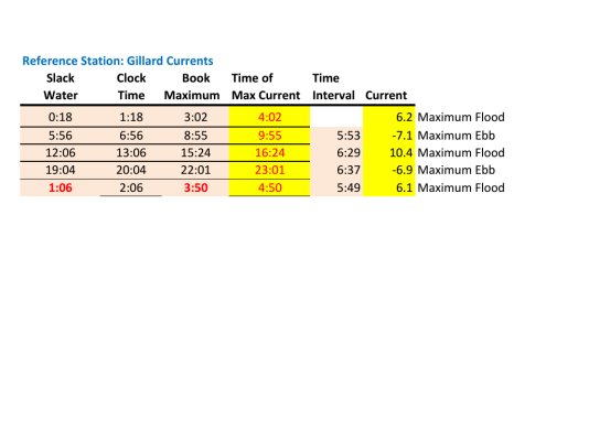
ImageUploadedByTrawler Forum1427334283.113202.jpg
Calculation of Secondary Stations for June 5, 2015 from Gillard Passage Reference Station.
ImageUploadedByTrawler Forum1427334396.660389.jpg
Graph of modelled time series, 28 hours.
ImageUploadedByTrawler Forum1427334458.376699.jpg
Graph of zoomed in period, Mid day.
ImageUploadedByTrawler Forum1427334528.824116.jpg


Jim
Sent from my iPad using Trawler Forum
 
Last edited:
So far, we have only been through the Yucultas twice, once in each direction. After reading everything I could, I planned the whole trip to be able to hit the Dent rapids at a convenient HW slack (turn to ebb) on a day with fairly minimal exchanges. I knew that would entail some remaining flood current at Yuculta and Gillard heading north, but from what I read that seemed manageable. We left Squirrel Cove with plenty of time to start our run from Pt Harbott about 50 minutes before Dent slack. We followed a recommended route (source forgotten at the moment, see my chart). Some mild swirlies scooting across from Pt Kelsey to the Sonora side and then again at the entrance to Gillard, but nothing bad. Still opposing current in Gillard pass but a little nudge on the throttles and we were smoothly though. Waited for maybe 10 minutes and then went through Dent right at the predicted slack. Duck Pond!

Coming back a few weeks later was easier as far as currents go. Again we hit Dent at HW slack and then slack(ish) water follows you through. That transit was made "interesting" by being completely fogged in from start to finish and in the close company of a small armada of boats only seen on radar. Thank you chartplotter with radar overlay.

So, good work Jim, but my simplistic plan for those rapids in the future is the same recipe. Plan to hit Dent at HW slack on a moderate exchange day and accept the current elsewhere. Now if I had a jet boat.....:)
 

Attachments

  • Yucultas passage north.jpg
    Yucultas passage north.jpg
    150.2 KB · Views: 201
Last edited:
Tonic, I agree. That's how we went through. My tidal program had the tides for the Yutes and Gilard Pass but not the Dents, so I calculated them manually. The purpose of this work was more for my own curiosity of how to model the cycling of currents, and also to display all the locations on one graph. Unfortunately you cannot download the numerical results from the tide programs. You can only see the results graphically and by individual station. Still, I will see how the program works this summer as I plan my transit through these passes.


Jim
Sent from my iPad using Trawler Forum
 
2016 we will be entering the "pools". I am told that since I boat in the lower Columbia it will be similar, just have time it right, Sounds like setting slack HW at Dent is the way to go.
 
The current is not as dangerous as the whirl pools you will encounter if you don't run them at slack. Once your caught up in one of those, you have real problems. Possibly even a disaster. As said before, if you can transit them on days with a small tidal exchange it will be much better.
 
The current in Dent is not the Columbia

Dent rapids is much narrower and turbulent than the lower Columbia. Serious whirlpools that will lay a sail boat on it's beam ends, spin a trawler end for end. Fun in a planing skiff, no joke in a slow displacement boat.
 
Jim

Is Arran slack close to your Dent calculations?
 
In Kevin Monahan's book"Local Knowledge" there's a great photo of a commercial fishing boat caught up in a whirlpool in the Dent's "Devils Hole". He provides strategies for transiting these rapids in this book.


Jim
Sent from my iPad using Trawler Forum
 
We always time our passage to hit DENT slack. This is the most important, to us. We want nothing to do with Devil's Hole. It forms on the flood due to interaction between Tugboat Passage and Dent passage streams. Water gets its spin from the Tugboat stream entering at ~ a 45o angle. No Devil's hole on the ebb that I am aware of.

I have seen Devils Hole whirlpool from a small boat at full flood. Small fast boats can skirt it but from what I saw a larger, slower boat is asking for trouble to ignore it. It looked like we were climbing up about 10' to get into the Tugboat passage. The stream pouring out of Tugboat was a lot higher than where it joined the Dent.

When going Yuculta, Gillard, Dent that means you will need to buck Yuculta starting about 30-40 min. early.

We have been through on a very small change where we were darned near an hour late and the water was very calm but do not count on it.
Usually even on small changes the currents can be quite strong.
It may not have taken much of an increase in the change to have caused us trouble.
And yes, fog, can be a definite problem.
 
Jim

Is Arran slack close to your Dent calculations?

It is close to Arran. If you use the off-sets in CHS, the Dents turn 15 minutes earlier than Gillard Passage on the Flood and are 25 minutes earlier on the Ebb. On June 5, Arran, Gillard (CHS Reference Station Tables) and the calculations for the Dents have following comparable times, adjusted for PDST:

ImageUploadedByTrawler Forum1427435980.784087.jpg

So the times of slack water as outcomes from the model for the Dents are close to the times which would be obtained for the Dents, following the CHS off-set guidelines for secondary stations. The exception is for the very large flood (>10 kts), where my model would suggest an earlier change for all stations. I'm not entirely sure why that is so, except it probably has something to do with the asymmetry in the magnitude of the ebb and flood tides, with the flood being 3+ knots faster than the flanking maximum ebbs tides.

Caveat Emptor: I'm not saying the outcomes from the model I have developed are correct. It is just another way of exploring an analysis of tidal currents.

Jim
Sent from my iPad using Trawler Forum
 
Last edited:
From the above posts, one would get the idea there are rapids and whirlpools at almost all stages of the tide.
Any time I have transited these passes, I have seen no rapids, no whirlpools. I always try to get through all the way as close to slack as possible. My boat does 8 knots, so I have never missed, relying on the CHS predictions.
Transiting any pass when there are whirlpools and rapids can be very exciting. Remember the barge that overtook its towboat in Skookumchuk a few years ago. And the Coast Guard Auxilliary RIB that flipped in the same pass a few years later. Loss of life in both incidents.
 
I don't predict anything. Like to spend the night at Big Bay and run Dent whenever it's slack the next day. Don't need to calculate anything as there will be a swarm of boats heading out near slack. After that we always seem to just go on through.

I think you guys are making a mountain out of a whirlpool.
 
I think you guys are making a mountain out of a whirlpool.

Eric

The beauty and curse of the Internet is our interests in details can be fulfilled on what some may view as mundane subjects. Let me tell you about a guy who has an obsession with anchoring minutae ----- :D
 
Eric

The beauty and curse of the Internet is our interests in details can be fulfilled on what some may view as mundane subjects. Let me tell you about a guy who has an obsession with anchoring minutae ----- :D
Thankfully the anchor minutiae keeps the QBBL debate down a deep, dark hole! :thumb:

I can see how some can get into the current predictions....it's something that affects me in both cruising and work related boating...just too many hard to determine variables in the waters I cruise.
 
Last edited:
Tom,
You're right there .. I'm not a detail guy. If I'm going to wallow in something it better be very meaningful. However some guys enjoy computation.

Scott,
The QBBL need not be in a dark hole. If understood it is enlightening. It's boring of course if it's not understood. I'm pleased thinking quite a few here understand more about speed and the FD hull than would otherwise if I hadn't pushed the concept home more than many liked. I'm glad you remembered it.

However, Scott your point that I poo poo computation re navigation and embrace it for hull design is a good point and well taken. But there's a point in NA that requires too much computation for me and I go find something else to do. Usually I only read certian parts of boat design books.
 
Last edited:
Yep, half the story is always half the story.

Thankfully our resident naval architect has pointed out often how one detail in design is just one detail, not a governing factor....especially the QBBL.

Thus also my point on figuring tidal currents, some places too many other factors decide...not just astronomical predictions.
 
Scott I probably shouldn't't have said anything.

And I'll apply that thought in the future.

The result is always the same
 
If you can find a copy ( and I cannot) look for "Oceanography of the British Columbia coast" by Richard Thomson". Rick is a pretty sharp guy and has been studying the oceanography of BC since the 1970's.

http://www.meds-sdmm.dfo-mpo.gc.ca/sdb-bds/profile-profil.do?id=1230&lang=eng

Mike Foreman is an another expert on tides with IOS.

http://www.meds-sdmm.dfo-mpo.gc.ca/sdb-bds/profile-profil.do?id=1214&lang=eng

Rick is out of town right now. Maybe I'll see of I can get some feedback from Mike Foreman.

A mentioned above, the Fraser River has a very strong effect on net tidal currents on the surface inside the Vancouver island area. It's influence extends north of Vancouver island. In addition, the rivers of Bute inlet (Homathko, Southgate and Orford Rivers) will have a strong effect in the Cordero Channel area. You can expect the effects to be strongest late April through early July. The effects of the Fraser can be expected to be pronounced this year with the higher than normal snow packs in the upper Fraser Watershed. The snowpacks in the Homathko area (BC south coast) are much lower than normal.

http://bcrfc.env.gov.bc.ca/bulletins/watersupply/current.htm


Jim
Sent from my iPad using Trawler Forum
 
If you can find a copy ( and I cannot) look for "Oceanography of the British Columbia coast" by Richard Thomson". Rick is a pretty sharp guy and has been studying the oceanography of BC since the 1970's.

DFO Scientist Directory

Mike Foreman is an another expert on tides with IOS.

DFO Scientist Directory

Rick is out of town right now. Maybe I'll see of I can get some feedback from Mike Foreman.

A mentioned above, the Fraser River has a very strong effect on net tidal currents on the surface inside the Vancouver island area. It's influence extends north of Vancouver island. In addition, the rivers of Bute inlet (Homathko, Southgate and Orford Rivers) will have a strong effect in the Cordero Channel area. You can expect the effects to be strongest late April through early July. The effects of the Fraser can be expected to be pronounced this year with the higher than normal snow packs in the upper Fraser Watershed. The snowpacks in the Homathko area (BC south coast) are much lower than normal.

River Forecast Centre – FLNRO – Province of British Columbia


Jim
Sent from my iPad using Trawler Forum
Curious....Are you trying to add those river effects into you calculations?
 
No...well beyond my capability. I've just had conversations with Rick Thomson about it several years ago now. His big emphasis at the time was the proud effect of the Fraser on local current dynamics. It flows at >10,000 cubic meters/second on some years at full freshet.

Rick also explained why my prawn pots moved in the opposite direction to wind during a particularly strong wind in Howe Sound one winter past.


Jim
Sent from my iPad using Trawler Forum
 
Amazingly enough, the Fraser freshet runs all the ways up to Powell River. I've flown over the Strait of Georgia every week for years and I still look down out the window and watch the water.

The rapids in this area should be respected.

In river talk they turn class 4 to 5 depending on the exchange.
 
We've never had trouble with finding slack. What we have had trouble with is the yahoos who roar through at 15 knots leaving giant wakes and standing waves. Given that there is always a bunch going thru at slack, rig for serious rolling before you enter because "they" will be there.
 
"RESIDUAL PLUS TIDAL STREAMS The tidal stream contribution will now be discussed in relation to the estuarine current. In the absence of any surface wind drift, the sum of these two accounts for nearly all the observed current speed and variability. Tidal streams are that part of the total current directly associated with the rise and fall of the tide; except where deflected by the bottom topography or coastline they produce no significant net drift over a period of a few tidal cycles, just as the tide produces no net change in the water depth. In reality, of course, those who make tidal predictions lump the pure tidal streams together with the residual currents to get a sort of hybrid tidal flow, a procedure that can be erroneous unless the residual current remains almost constant over many weeks and months. As the residual flow is not generally constant because of variability in the various mechanisms that produce it, current predictions are often incorrect, particularly for times of slack water." Page 209 from Thomson, R.E. 1981. Oceanography of the British Columbia Coast. Can. Spec. Pub. Fish. Aquat. Sci. 309 p.

The above pertains to the effect of estuarine flows from rivers, which are not constant throughout the year. This probably means that estimates of currents "particularly for times of slack water" from tide tables will be in error during freshets (May, June) and during periods of low flows (December, January).


Jim
Sent from my iPad using Trawler Forum
 
Jim,

The questions I would have:

Aren't typical seasonal variations in river flows already taken into account in the published tables, since they are based on measurements?

How large are the effects of year-to-year variation in river flows on tides and currents at a place like Yuculta?
 
My take is that river flows are at best an average based on flow meter measurements.....not any more accurate than an Verage
 
Jim,

The questions I would have:

Aren't typical seasonal variations in river flows already taken into account in the published tables, since they are based on measurements?

How large are the effects of year-to-year variation in river flows on tides and currents at a place like Yuculta?


I get the sense that they probably are not taken into account. If they incorporate seasonal variation, the interannual effects would not be included of course and would result in prediction error. I will try and ask one of the IOS types if I get the chance.

Your second question is a very good one and I cannot answer it. I would suspect that the freshet coming out of Bute Inlet may have a pretty pronounced effect on the currents in this area.

Jim
Sent from my iPad using Trawler Forum
 
Last edited:
Back
Top Bottom