You are using an out of date browser. It may not display this or other websites correctly.
You should upgrade or use an alternative browser.
You should upgrade or use an alternative browser.
Automatic Identification Systems
- Thread starter GreenSailor
- Start date
The friendliest place on the web for anyone who enjoys boating.
If you have answers, please help by responding to the unanswered posts.
If you have answers, please help by responding to the unanswered posts.

I suppose if one runs their boat in the same lanes the ferries use there's good reason to be worried. We don't so we aren't. In our experience there is more than enough room in Active Pass, Wasp Passage, etc to go through them with no danger of occupying the same lane, as it were, with a ferry if one comes through. We also aren't real paranoid about being in fairly close proximity to other vessels if the visibility is sufficient.
Sorry, but we just don't see the urgency or drama in the boating environment up here. The notion of vessels flying around corners and popping out of nowhere simply isn't the reality in our experience. In fact we find boating to be a very slow-motion experience with more than enough time to avoid traffic conflicts. Perhaps because we're comparing it to operating a floatplane in the same area, I don't know.
But we've never felt we were in peril from other traffic, at least not so far.
Attachments
Last edited:
Conrad
Guru
- Joined
- Oct 19, 2007
- Messages
- 1,972
- Location
- Canada
- Vessel Name
- Blue Sky
- Vessel Make
- Nordic Tugs 42 Hull #001
In our area (Campbell River, Desolation Sound, The Broughtons, etc.) I've never felt the need for AIS as we tend to move on the water only when there is reasonable visibility. E.g., I would never knowingly go out in fog, although can deal with it if caught in it.
As it happens we are adding a second VHF to Blue Sky so have pretty much decided on a Standard Horizon GX2200 which comes with AIS. I'm looking forward to seeing the AIS transmitting vessels on the water and all of the info they provide.
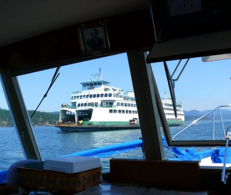
Yes, we will be receiving only, but has been mentioned it will be nice to keep track of the big boys especially the ferry traffic, which can sometimes appear seemingly out of nowhere. Or suddenly pull out of their berth just as you are passing by.
Because the AIS in this form comes essentially free, I view it as an interesting addition rather than a necessary one.
As it happens we are adding a second VHF to Blue Sky so have pretty much decided on a Standard Horizon GX2200 which comes with AIS. I'm looking forward to seeing the AIS transmitting vessels on the water and all of the info they provide.
Yes, we will be receiving only, but has been mentioned it will be nice to keep track of the big boys especially the ferry traffic, which can sometimes appear seemingly out of nowhere. Or suddenly pull out of their berth just as you are passing by.
Because the AIS in this form comes essentially free, I view it as an interesting addition rather than a necessary one.
cappy208
Guru
Just to be sure we are debating based on correct facts.... Class B transmits at 30 sec intervals when your boat is moving. If your boat is running at 2 kts or less then the report interval is 3 minutes. I don't believe there is any situation where it will be 10 minutes.
Class A transmits at between 2 and 10 second intervals depending on the boat's speed and rate of turn.
So there is a difference, but it's not that huge.
You are correct in the published transmission rates. However, in practice I have seen much longer delays. It may be antenna issues, or other interference. But, having seen numerous occasions showing great lagging in presentation there seems to be a larger gap between A and B. Of course my '10 minute' may just be exaggerated by wishing the info would update quicker.
psneeld
Guru
after a winters cruising with the same radio....as I posted earlier...,many a day has gone by with either not one signal or the few commercial vessels were snug in their slips. Plenty of traffic though...had it been foggy though, it may have added some comfort...but in broad daylight and clear vis, all the ICW hogs managed near misses and forced me out of the channel anyway.In our area (Campbell River, Desolation Sound, The Broughtons, etc.) I've never felt the need for AIS as we tend to move on the water only when there is reasonable visibility. E.g., I would never knowingly go out in fog, although can deal with it if caught in it.
As it happens we are adding a second VHF to Blue Sky so have pretty much decided on a Standard Horizon GX2200 which comes with AIS. I'm looking forward to seeing the AIS transmitting vessels on the water and all of the info they provide.
Yes, we will be receiving only, but has been mentioned it will be nice to keep track of the big boys especially the ferry traffic, which can sometimes appear seemingly out of nowhere. Or suddenly pull out of their berth just as you are passing by.
Because the AIS in this form comes essentially free, I view it as an interesting addition rather than a necessary one.
In many places the dangerous and unpredictable traffic doesn't transmit anyhow. In my world ferries announce leaving their berth and transmit safety info when turning into canals or departing breakwaters. With predictable speeds...even in fog ferries aren't a surprise for me. It's the big boys in the channel the use AIS...and it's easy to stay out of the channel.
My biggest worry is the guy in the 26 foot tug, pushing a 100 foot barge. He is not required to have a captains license, the tug might be a total shambles and a handful to operate, he might not be able to see around the crane on deck, no watch on the barge a d operating the same tight areas I may be running. Definitely no AIS onboard either.
So while I enjoy the AIS in my radio, after 2000 miles of busy waterways, it has proven itself to just where I thought it would.....till it is required for virtually everyone....the old methods of avoiding traffic are satisfactory u less you specifically travel in lanes by traffic that is required to have it and in lower than optimal visability.
JDCAVE
Guru
- Joined
- Apr 3, 2011
- Messages
- 2,906
- Location
- Canada
- Vessel Name
- Phoenix Hunter
- Vessel Make
- Kadey Krogen 42 (1985)
after a winters cruising with the same radio....as I posted earlier...,many a day has gone by with either not one signal or the few commercial vessels were snug in their slips. Plenty of traffic though...had it been foggy though, it may have added some comfort...but in broad daylight and clear vis, all the ICW hogs managed near misses and forced me out of the channel anyway.
In many places the dangerous and unpredictable traffic doesn't transmit anyhow. In my world ferries announce leaving their berth and transmit safety info when turning into canals or departing breakwaters. With predictable speeds...even in fog ferries aren't a surprise for me. It's the big boys in the channel the use AIS...and it's easy to stay out of the channel.
My biggest worry is the guy in the 26 foot tug, pushing a 100 foot barge. He is not required to have a captains license, the tug might be a total shambles and a handful to operate, he might not be able to see around the crane on deck, no watch on the barge a d operating the same tight areas I may be running. Definitely no AIS onboard either.
So while I enjoy the AIS in my radio, after 2000 miles of busy waterways, it has proven itself to just where I thought it would.....till it is required for virtually everyone....the old methods of avoiding traffic are satisfactory u less you specifically travel in lanes by traffic that is required to have it and in lower than optimal visability.
We had a situation last summer in pea soup fog in Browning Passage where a small tug and tow wasn't broadcasting AIS. We would have given him more room if we had known he had a tow. However, a bigger problem was the sport fishing charter boat traveling at 25 kts that we watched on radar wondering what-in-the-hell to do. We throttled right back and watched,as he shot straight across our bow. While he didn't have AIS, the bigger problem was he was travelling far too fast for the low visibility situation and probably wasn't paying attention to his radar.
Jim
Sent from my iPad using Trawler Forum
Alaskan Sea-Duction
Guru
- Joined
- Jul 6, 2012
- Messages
- 8,058
- Location
- USA
- Vessel Name
- Alaskan Sea-Duction
- Vessel Make
- 1988 M/Y Camargue YachtFisher
WOW this thread took on its own life, almost as bad as anchors and rodes!
Marin brings up some good points if you are familar with the area. For me, I invested into the AIS system as another tool to "help" keep me, the Admiral, and ASD safe. Just another tool, like radar, VHF radio, MFD etc.
Marin brings up some good points if you are familar with the area. For me, I invested into the AIS system as another tool to "help" keep me, the Admiral, and ASD safe. Just another tool, like radar, VHF radio, MFD etc.
True, AIS doesn't help track boats that do not have it installed. And the 25 kts charter boat would probably be Class B if she did have it - the only useful info might be the names / MMSI for hailing.We had a situation last summer in pea soup fog in Browning Passage where a small tug and tow wasn't broadcasting AIS. We would have given him more room if we had known he had a tow. However, a bigger problem was the sport fishing charter boat traveling at 25 kts that we watched on radar wondering what-in-the-hell to do. We throttled right back and watched,as he shot straight across our bow. While he didn't have AIS, the bigger problem was he was travelling far too fast for the low visibility situation and probably wasn't paying attention to his radar.
Really, AIS doesn't help with most traffic you encounter. But it helps with the larger, commercial, and essentially more predictable vessels - taking them off of your list of things to worry about.
ranger58sb
Guru
British Columbia Ferries
Ah. Did you mean to imply they had something to do with the Empress of the North incident?
-Chris
Britannia
Wannabe
For the record I have a class B transponder that I will be installing aboard Stillwater for our passage from Ketchikan to SF Bay. I'm unfamiliar with the route and figured I could use all the help I can get. I'm hoping it will be useful both in the busier areas around Vancouver Island and the north end of Puget Sound, as well as the coastal passage where we'll probably only see the occasional ship - but not want to miss it when there is one. Well, actually we will want to miss it. You know what I mean...
Ah. Did you mean to imply they had something to do with the Empress of the North incident?
-Chris
Koliver was referring to the Queen of the North, which was a BC Ferry. Not the Empress of the North.
ranger58sb
Guru
Ah, so. Got it. Thought that had been a typo or something, since I knew there was an Empress of the North incident ")
-Chris
-Chris
...Really, AIS doesn't help with most traffic you encounter. But it helps with the larger, commercial, and essentially more predictable vessels - taking them off of your list of things to worry about.
 That's been our experience. The little guys do not have AIS.
JDCAVE
Guru
- Joined
- Apr 3, 2011
- Messages
- 2,906
- Location
- Canada
- Vessel Name
- Phoenix Hunter
- Vessel Make
- Kadey Krogen 42 (1985)
This came up on another forum.
http://www.professionalmariner.com/August-2014/synthetic-aids-virtual-buoys/
Perhaps a reason for Marin to install AIS?
Jim
Sent from my iPad using Trawler Forum
http://www.professionalmariner.com/August-2014/synthetic-aids-virtual-buoys/
Perhaps a reason for Marin to install AIS?
Jim
Sent from my iPad using Trawler Forum
This came up on another forum.
U.S. Coast Guard begins testing synthetic aids, virtual buoys - Professional Mariner - August 2014
Perhaps a reason for Marin to install AIS
Don't think so. Using virtual AIS positions seems a real benefit to marking things like individual bridge piers as mentioned in the article.
But for enhancing existing navaids, I don't see it as any value to us and the way we boat. We rarely refer to the navaids that are in place now in terms of our navigation. They are all on the plotters and charts we use to navigate with and the only times we use the physical navaids are as visual confirmations of what we already know.
Islands, rocks, and reefs generally don't appear overnight in this region, and we've noticed that the existing islands, rocks, and reefs tend to remain in position for long periods of time.
In the words of a notable Union Steamship Company captain when asked how he remembered the locations of all the rocks and reefs along the BC raincoast, "I don't have to remember where all the rocks are, I just have to remember where they ain't."
cappy208
Guru
These new virtual buoys are a pain. They are the location of where the buoys SUPPOSED to be. Often buoys move. (Or in the case of the frozen rivers get dragged). It would be better to have buoys with actual transponders on them. But batteries are an issue.
ulysses
Guru
Most all lighted buoys and beacons are now solar powered. So if a buoy is off of its charted location there are two things that may have happened: 1. Channel has changed and buoy was reset, which leads to checking "Local Notices to Mariners" 2. Buoy has been drug off location, broke loss, or is otherwise a stray.
To replace that buoy temporarily in the proper location a virtual buoy would be ideal in my opinion. At least til the CG buoy tender makes its rounds.
Granted that the rocks seldom move, the river and entrance channels do.
dan
To replace that buoy temporarily in the proper location a virtual buoy would be ideal in my opinion. At least til the CG buoy tender makes its rounds.
Granted that the rocks seldom move, the river and entrance channels do.
dan
BlueYonder
Senior Member
Also, a couple of months ago someone here also complained that some boats leave their AIS's on when tied up at marinas. Really? That's a problem somehow? Seems like complaining just to complain.
If you have your AIS setup to include an automatic proximity warning, you get to cruise in and out of your marina constantly punching off AIS warnings. My marina alone has 5 or 6 boats that never leave the dock, but broadcast their AIS location 24 hours a day.
cappy208
Guru
The constant leaving on ais units clogs the system and degrades overall performance of the reception. It seem many people have the 'I want to be seen (and my boat) mentality' even when tied up at the dock.
Also, all AIS have a function (that is used on commercial vessels) noting the Nav status. Underway, moored, anchored, aground, NUC or RAM. When at anything but underway the pulse rate is slowed down to around 10 minutes. As opposed to underway which is almost constantly updating information By leaving the AIS on at a dock it is unnecessarily cluttering up the system. And I have only found a smattering of yachts that even know about changing Nav status.
Regarding the ais virtual buoy: They clutter up the AI display. I am not worried about CPA or TCPA to the next 7 buoys. I am concerned with the ship 7 miles ahead, and the Tug and Barge between us and where we should meet. I have not found a way to 'shut off' the virtual buoys. (yet)
If you have your AIS setup to include an automatic proximity warning, you get to cruise in and out of your marina constantly punching off AIS warnings. My marina alone has 5 or 6 boats that never leave the dock, but broadcast their AIS location 24 hours a day.
Yes, that would be annoying. Our marina has at least 10. However, my system allows ignoring of stationary targets (I turn this feature off during limited visibility), so it's not a problem for me. I guess I assumed that everybody has such an "off" switch also. If you have one, maybe you should try it.
And Cappy 208, I have never experienced too much clutter, nor do I understand a "clogged system". What is the symptom?
Last edited:
ulysses
Guru
I have noticed that an aid to navigation with a racon beacon will also clutter up the radar screen but I certainly appreciate the assistance from the beacon. I think that we may all be forgetting the fact that AIS is just another tool to aid in safe navigation. If you think that it is not performing that task, you need only find the power switch to eliminate it from your tool box.
dan
dan
cappy208
Guru
Recalling some technical publications from several years ago:
The reason they have several different levels of communication is they realized the system would get overloaded (on the government end) during transmitting and repeating of data if every conceivable AIS was transmitting ALL the time.
They figured that by changing the transmission rates depending on what a particular vessel was doing would give more bandwidth to the system for more important transmissions. Thus the Underway having the most priority (most frequent transmissions) down to the anchored, aground, moored having the fewest transmissions.
From a practical standpoint, my radar screens routinely have 60 to 100 AIS targets on them when I am transiting NY harbor. Now, You and I both know that there aren't 100 boats underway in the Harbor. (ok, Maybe in the harbor, but not underway) But there are literally dozens that are tied up, secure, or simply out of service for the day that are transmitting. Could You or I for all practical purposes notice a difference? Probably not. But there are SO many it clutters up the plotter, and Radar screen unnecessarily.
When I get back into the Harbor I will try to take a screen shot of the Radar screen with the dozens and dozens of AIS targets on it.
markpierce
Master and Commander
- Joined
- Sep 25, 2010
- Messages
- 12,557
- Location
- USA
- Vessel Name
- Carquinez Coot
- Vessel Make
- penultimate Seahorse Marine Coot hull #6
As more boats have AIS, more will be filtered/not-displayed. More than already are, that is.
jjanacek
Veteran Member
We're still limping along without AIS, as we have no space on the helm for another device and don't like the idea of just having a receiver or we would get the SH VHS/AIS receiver combo, despite its awful display. Our chart plotter came over with Columbus (Raymarine RL80CRC) and only speaks 4800 baud, so no AIS will talk to it. So far I think our only options are to get a Vesper XB-8000 to talk to the iPad or upgrade our chart plotters to Raymarine E80's so we can use most of our existing cabling. But today we are suffering through terrific weather on Eleuthera, AISless, but we rarely see other boats, and if we do they are a ways off.
Last edited:
There are some additional AIS tidbits in Ben Ellison's latest AIS post.
I had forgotten that Class A is 12W versus 2W for Class B, but this transmission interval chart was new to me:
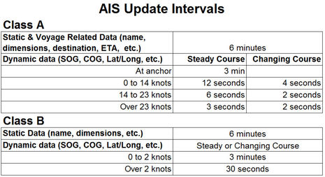
I had forgotten that Class A is 12W versus 2W for Class B, but this transmission interval chart was new to me:
ulysses
Guru
Many years ago I spent some time pushing heavy tows on the Western Rivers. We had a VHF, Whistle with a whistle activated light, and a radar that did not see around a bend in the river. It was common practice to report your position prior to making bends and/or bridges, etc.. on the VHF.
I just went up the Tom Bigbee and was greatly surprised with the impact the AIS system has made on the rivers. No "clutter" due to line of sight, descending (privlidged vessel) would call you by name and know exactly where you were. No more lying about your speed or where you were. A whole lot less VHF traffic. Seemed to work out well for all concerned.
dan