Furuno NavNet 3d

The friendliest place on the web for anyone who enjoys boating.
If you have answers, please help by responding to the unanswered posts.

ralphyost

Senior Member
Joined
Oct 18, 2007
Messages
261
Location
USA
Vessel Name
Say GoodBye
Vessel Make
21 Mako
I'm seriously considering a major electronics upgrade for my boat. Been looking at various systems and am attracted to many features in the Furuno NavNet 3d system.

I would like to hear from any of you that have it - pros, cons, etc.

I was on a boat that had it this summer and the owners are still very impressed with it.
 
I am on my phone so I can't go into detail. Will reply tomorrow when I get home. What exactly do you want to know???
 
Can't answer your query about NavNet 3D but I can tell you that the Furuno NavNet VX2 that we put on our boat a few years ago is outstanding. We were replacing an ancient 1980s vintage CRT Raytheon 2600 radar and we went with the NavNet so we could add a second dedicated plotter as well.

We use C-Map on our boat which we believe is superior to Navionics and the other charting systems but that's a personal preference.

We did not get the depth sounder option as our boat already has a good albeit old muti-function sounder/knotmeter/etc unit.

We went with Furuno because.... well, take a look at the commercial boats near you. In our neck of the woods everything from the big tractor tugs to little bow pickers use Furuno almost exclusively. Years ago I filmed for several days aboard the carrier USS Constellation out in the middle of the Pacific. In addition to the ship's huge purpose-built radar systems, there were several off-the-shelf Furuno units mounted on the island as well.

If the NavNet 3D system is anywhere near as user-friendly and comprehensive as NavNet VX 2 I would certainly recommend it if its features are what you want or need.

I would recommend that whatever you get, try to get a 10" screen (at least). Our boat was fitted by a PO with a very clever retractable radar display mount that disappears up into the main cabin overhead when the radar is not in use. I really like the mount as it makes the installation of a radar display child's play but unfortunately it would only accomodate the 7" screen NavNet unless we performed major surgery on the mount that we weren't willing to do. This has not proven to be a problem since the mount positions the display very close above and in front of the helmsman so the 7" screen size is fine. But given the option I would always recommend the larger screen size.

Were we in the market for a new radar or radar/plotter today we would consider only Furuno. The fact they have a factory service center in the PNW doesn't hurt either, although nobody seems to need it
smile.gif
 
I echo the suggestion to go with Furuno although I have never had one. Thousands of commercial vessels and professional fishermen can't be wrong. I will say, however, that the Simrad NSE (NorthStar Edition) and high end Garmin products are worth investigating. Their graphics and intuativeness are unbelievable!
I have a NorsthStar 6000i at the present time and can't imagine ever changing it out but if and when that time ever comes, I'll probably go with Furuno.


-- Edited by SeaHorse II on Thursday 26th of August 2010 10:37:52 AM
 

Attachments

  • fish finder.jpg
    fish finder.jpg
    146.8 KB · Views: 173
  • radar.jpg
    radar.jpg
    164.9 KB · Views: 130
  • chart plotter.jpg
    chart plotter.jpg
    136.6 KB · Views: 134
  • radome.jpg
    radome.jpg
    73.7 KB · Views: 137
  • dscn1211.jpg
    dscn1211.jpg
    57.3 KB · Views: 136
Furuno sells an 8" and 12" chart plotter. I am going to put the 12" chartplotter on my fly bridge. Then I will use my laptop when steering down below. Their MaxSea Time Zero chart plotter software allows me to get everything that the chartplotter gets, including the radar and the ability to run two different radar range displays simultaneously. I think that is a really awesom and very useful feature.
Here is my basic system component list -

<table style="border-collapse:collapse;width:273px;height:214px;" border="0" cellpadding="0" cellspacing="0"><col style="width:174pt;" width="232" /><tbody><tr style="height:12.75pt;"><td style="height:12.75pt;width:174pt;" width="232" height="17">
</td></tr><tr style="height:12.75pt;"><td style="height:12.75pt;" height="17">Navnet 3d MFD1212" Display 800x600</td></tr><tr style="height:12.75pt;"><td style="height:12.75pt;" height="17">Laptop: MaxSea Software TZ Explorer</td></tr><tr style="height:12.75pt;"><td style="height:12.75pt;" height="17">24" 3D Ultra HD dig radar dome 4KW DRS4D</td></tr><tr style="height:12.75pt;"><td style="height:12.75pt;" height="17">24" Radar mast mount</td></tr><tr style="height:12.75pt;"><td style="height:12.75pt;" height="17">DFF1 Network Sounder</td></tr><tr style="height:12.75pt;"><td style="height:12.75pt;" height="17">Ethernet Hub for Navnet 3D</td></tr><tr style="height:12.75pt;"><td style="height:12.75pt;" height="17">GPS Antenna NMEA2000 for Navnet3D</td></tr><tr style="height:12.75pt;"><td style="height:12.75pt;" height="17">Transom MountXducer</td></tr><tr style="height:12.75pt;"><td style="height:12.75pt;" height="17">AIS FA50 Transponder Class B</td></tr></tbody></table>
I called Furuno and spoke with a technical guy who was very knowledgable, He told me the following -
<table style="border-collapse:collapse;width:278px;height:135px;" border="0" cellpadding="0" cellspacing="0"><col style="width:158pt;" width="211" /><tbody><tr style="height:12.75pt;"><td style="height:12.75pt;width:158pt;" width="211" height="17">pre-loaded with full-scale, complete NOAA raster and vector chart libraries for the entire U.S. coastline</td></tr><tr style="height:12.75pt;"><td style="height:12.75pt;" height="17">Control up to 4 AXIS IP cameras</td></tr><tr style="height:12.75pt;"><td style="height:12.75pt;" height="17">Uses MAPMEDIA charts</td></tr><tr style="height:12.75pt;"><td style="height:12.75pt;" height="17">700 NOAA vector charts for US are FREE and built in.</td></tr><tr style="height:12.75pt;"><td style="height:12.75pt;" height="17">The 3D chart function is built in</td></tr></tbody></table>
 
Regarding radar.
I was told by a Furuno tec that A radar unit will last longer if used all the time.
So crank em up and let em run, all the time.

What about a lap top with a plotter *program.*I have heard there are some fairly good ones out there
**
Any one use this method for a plotter?

SD

-- Edited by skipperdude on Thursday 26th of August 2010 11:24:51 AM
 
skipperdude wrote:What about a lap top with a plotter *program.*I have heard there are some fairly good ones out there


Any one use this method for a plotter?


There are some good plotter apps out there for laptops.* I know people who have them and use them and are very satisfied with them.* I also just heard this story this weekend when we were out.*

Fellow has a laptop with whatever navigation app installed.* Uses it as his primary nav system.* Not long ago he was entering a very tricky channel up here somewhere with several accompanying boats following him since he had the best--- or most recent--- nav system.* Right in the middle of negotiating this difficult channel in bad currents his laptop starts asking him if he wants to upgrade some Microsoft feature.* It persistently asks him this which over-rode his nav system display.* He'd hit "No" and within seconds it would be asking him again.

They got into the bay without incident but he said it was exremely un-nerving having one's nav system become effectively inopperative at a time when it was needed most.

While I have always felt this way, this story very neatly sums up why we have no interest in having a laptop-based nav system on the boat, at least not as the primary system.* I, like probably most people on this forum, use Microsoft operating systems on the computers I use at work (I use Mac at home).* Based on the experience over many years of using Microsoft systems, there is no way in hell I'm going to layer a navigation app, which may be extremely good, on top of anything the Microsoft Kids come up with.

We have two stand-alone navigation systems on our boat.* Three if you coun't the C-Map handheld Magellen we bought years ago.* When we bought the boat it only had a Furuno Loran-C unit for navigation.* But the boat had spent its whole life in San Francisco Bay and the Sacramento River so how much electronic nav aid to you need?
smile.gif


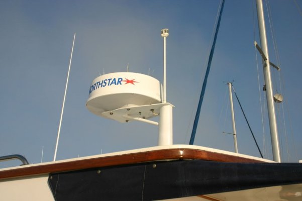
We immediately added an Echotec 310MP* GPS plotter (C-Map), which in 1998 was state-of-the art in plotter technology.* It was the system favored by the majority of the PNW fishing fleet (Echotec was a local company).* It has served us well and still works as advertised although it's not nearly as user-friendly as the current systems.

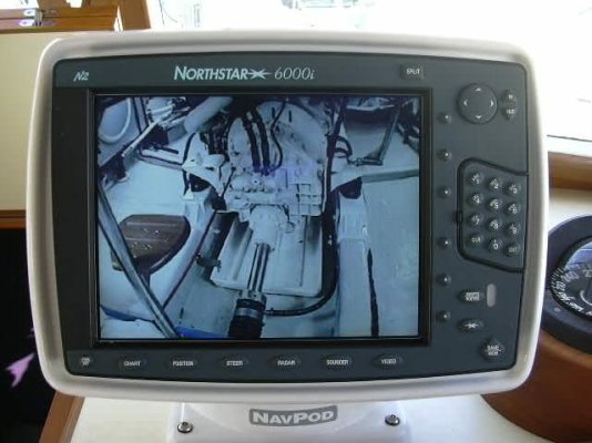
As mentioned in another post, when the radar that came with the boat began to fail, we replaced it with a Furuno NavNet VX2.* We only drive the boat from the lower helm so we had no need of any nav information at the upper helm (alhtough we can mount the portable Magellen up there if we want to).

In twelve years of running this boat we have never had a nav system problem.* Yes, our old Echotec and our newer Furuno are computers---- that's what makes them work.* But they are computers that only do one thing--- provide nav information.* I'm not interested in getting e-mail and surfing the web on* my nav system.* But my biggest objection to laptop (or full-size PC) based nav systems is that I don't want the Microsoft Kids anywhere near what we're using to navigate our boat.* I've read posts on T&T from people who spent an HOUR trying figure out how to increase the brightness of a laptop nav display.* The commands for this were buried in the most illogical place imaginable (typical for MS).* Meanwhile they're bobbing around in the fairway unable to go anywhere.* I've read posts about lockups, crashes, re-boots, etc.* They don't happen a lot, I guess, but when they do it always seems to be at the most inopportune time.* Same law that applies to having an engine problem.

So my philosophy is why open the door to the problem at all?

There are a lot of people who swear by their laptop-based nav systems and I don't argue with their success.* And computers are more reliable than they used to be.* But I don't believe the problems have anything much to do with the computers themselves.* It's the operating system designers (Micrsoft software engineers have been called the sloppiest code writers on the planet and for good reason) that are at fault in my opinion.* So we simply refuse to let them on the boat.


-- Edited by Marin on Thursday 26th of August 2010 12:46:10 PM
 
I have used The Capn for the past 4.5 years on a laptop and it works pretty well. Ideally I would like to have a chart plotter and the laptop in case one or the other fails. One of the things I like the best is using a keyboard and mouse. I also have an AIS receiver*hooked into the laptop*to display*AIS info in The Capn. *They use to offer a free 30 day trial, but I dont see that on the website anymore. Fugawi and Rose Point both have 30 day trials, might be worth playing with a few of them before investing in one.
 
I have used the Capn charting program since Windows replaced Dos as the OS on my laptop. I am currently using Capn 8.x (not the very latest, I think they are in 9.x or 10.x by now). the upgrades I have purchased when I upgraded my laptop to the next+1 gen OS. The Capn upgrades cost $75 or $100 each. The version that I currently run, on Vista, is perfectly stable, has none of the interruptions Marin describes ( those can be controlled easily by whoever sets up your laptop) and will allow AIS and depth information. The later versions will also allow Radar overlay. You can display as many or as few routes and prior tracks as you want, waypoints can display photos if you want. Routes can be created in a matter of a few mouse clicks.

This summer I also used a Humminbird Chart plotter/sounder on my new dinghy, and plotted the location and production of my prawn traps. For that purpose the plotter was excellent and handy enough, but when it is back on the flybridge, it is a real PITA to use for routes, compared to the laptop down below. The plotter uses a $175 chip of charts for this area, but the detail sucks when compared to the CHS (same as the paper ones) charts used in the Capn.
 
We too use a laptop* and ours did the same thing with attempting to update.

We learned to shut off the wifi card.*** If it can't find a network it can't download updates so won't interfere.** We have found unsecured networks all over the place so just be sure the card is disabled.
 
I have been using computer based plotter software (windows based) as my main plotter for the last 15 years.
Rule 1. Never have your prime nav software computer internet accessable.
Only do upgrades via a separate unit.
My laptop is my backup unit, along with 3 other GPS ants, a Northstar 6" plotter/sounder combo (actually for the tender) and a hand held.

I have never experienced any trouble with my computers except for one monitor failure but my TV can be connected as a backup.

One actually has a much more powerfull system this way with an endless memory for tracks and routes.
That's my 2c worth.

Benn
 
All good comments, and I pretty much agree with Marin's view except that I do use one laptop for secondary nav and general Internet use. However, like Marin, I have an extensive background with computers and networks so I am aware of the pitfals.

If you examine the level of integration that Furuno now has with their MaxSea Time Zero software and their GPS chartplotters, you can see some really neat flexibility and possible backup capability. Your networked laptop can have ALL the waypoints and routes from the chartplotter saved on the laptop. You get complete control of the radar and all the charts on the chartplotter are available on the laptop.
R.
 
Hi Ralph:

After 3 months with NN3 and Nobeltec running side by side I offer:
--The Furuno radar is great
--Nobeltec is far easier and quicker to plot with and lay out the next day's journey
--AIS is easier to use for me on the laptop based syatem than on NN3

For my bridge I'm considering a Big Bay monitor repeating NN3 screen. I'm not sure yet if it would be that much cheaper (or better)*though than the 8" MFD on the fly bridge.

Tom
 
Hey Tom
Good to connect up with you again.
Thanks for the report on NN3d.
R.
 
My wife works for the local Furuno dealer and are also close friends. We were talking about this yesterday. His general input is that Furuno designs things similarly to aircraft and their avionics are designed. His example of this is that the charts and the app that runs that is totally different from the hardware that stores the brains of the whole system. So if one breaks, you are still left with some functionality. He was talking fast and I was grasping it at the time and hard to recall at this point but if the board where the charts are stored breaks, you will still have GPS and Radar although your charts will not work. Raymarine puts everything on one chip. If it fails, the whole system goes down. With all due respect to the folks that have Raymarine on board, Raymarine is crap compared to Furuno. Furuno does not even allow any OEM installations. They do not trust manufacturers to install their systems properly because they know that the manufacturers likely have agendas pushing them that may cause them to do a poor job on an install(y'all know exactly what I am talking about). ONLY authorized dealers and service centers do installations of Furuno....or DIY obviously. To take it a step further, Furuno does not make touchscreens. They just do not believe in the reliability of the technology....IOW, too many things can go wrong. While they don't really believe in NMEA 2000, they are forced into it by the market....again, a reliability issue. This is just some of the things he was talking about. He does have a customer that has brand new G series Raymarine(I did not even know they existed) and he cannot wait to rip the things out and put in Furuno Black Box. The Raymarine system has performed very poorly for them and that is high dollar shyt. *These dudes are SERIOUS fishermen and he says keeping the Raymarine system running is a continuous battle...something is always screwed up. *They even took a picture of one of the deckhands up on top of the tower right next to an inoperative radar scanner(latest digital broadband type) with binoculars....since the radar was not working. *In the contest of it all, it was pretty funny and got a great laugh on the sportfish forums...but not really all that funny when you spend that kind of money and it can't be relied upon.

To put it simply and to copy GMC.....Furuno is Professional Grade!...made for performance first and flashy golly gee whiz after that. It seems Raymarine and Garmin spend more resources on the user interface and the root of the system is secondary.

FWIW and YMMV!!!!

-- Edited by Baker on Tuesday 31st of August 2010 03:38:53 PM
 
I have read that all of the marine electronics manufacturers have had issues. However, I have also read many satisfied Furuno customers who have needed Furuno tech support.....and yet still came away pleased. That is worth a lot to me.

I get very frustrated when I call for tech support and come away feeling like I knew more about the problem and situation than they did........that's the opposite of how I should feel.

I was on a boat this summer that was the very first Furuno NavNet3d installation on the Chesapeake Bay....black box system installed by MidShore Electronics in Cambridge MD. The owner (former Merchant Marine) had some initial issues, mostly due to early software release, but even so, were still very quick to recommend Furuno to me, the NavNet3d system, and MidShore Electronics.

Garmin customers also appear to be generally satisfied. Most Garmin owners will recommend Garmin. The Garmin 6000 series and 7000 series is the same exact system except that you pay about $1000 more for the touchscreen of the 7000 series.

I really like the broadband radar that Simrad/Northstar/Lowrance has, but was not enamoured with their chart plotter system.

One thing I learned about the Furuno 12" chartplotter is that you have to go to the plotter to turn it on each time. Simply applying power to it from down below will not turn it on. This is a negative feature for me as when the weather is crappy and I will be using the laptop MaxSea Time Zero chartplotting software, I will be relying on the NMEA bus from the chartplotter on the fly bride. This means I will have to go outside and up top just to turn it on. What a nuisance !

R.
 
ralphyost wrote:
One thing I learned about the Furuno 12" chartplotter is that you have to go to the plotter to turn it on each time. Simply applying power to it from down below will not turn it on. This is a negative feature for me as when the weather is crappy and I will be using the laptop MaxSea Time Zero chartplotting software, I will be relying on the NMEA bus from the chartplotter on the fly bride. This means I will have to go outside and up top just to turn it on. What a nuisance !
Thanks for that gem of information.* We will certainly keep that in mind as we set up our nav electronics on our new boat.*

*
 
Note that this is what I was told by MidShore Electronics in Cambridge. THey are probably right, but I am a verifier person. So I'll call my contact at Furuno to verify it.
R.,
 
We are in the throes of upgrading our entire electronics suite on our boat. Having looked at demo models of the Furuno NavNet2 and Navnet3d models on the dealer's shelves, I'm pretty much convinced that the NavNet2 is for us. Much more intuitive to operate, and it has been out since around 2002 so has been well proven. In fact apparently it is still the biggest seller is Furuno's lineup.*
I found that the NavNet 3d was overly complex, which isn't necessarily a bad thing if the benefits are there (which they may well be) but for someone who only can only get out on the water after winter layovers, I much prefer a system that allows me to get back up to speed quickly while I'm trying to remember the difference between a rolling hitch and and a bowline.
 
"while I'm trying to remember the difference between a rolling hitch and and a bowline."


What's that?
 
A "Rolling Hitch" is what you get at a drive through wedding chapel and "A Bowline" is what you do on your honeymoon. Five or ten pin, your choice.*
 
Conrad

I*have 2 Furuno NN3s. Overly complicated you say- IMHO not nearly as*complicated as the old Raymarine RL70Cs they replaced.
 

Latest posts

Back
Top Bottom