You are using an out of date browser. It may not display this or other websites correctly.
You should upgrade or use an alternative browser.
You should upgrade or use an alternative browser.
Change out of electronics on my boat
- Thread starter twistedtree
- Start date
The friendliest place on the web for anyone who enjoys boating.
If you have answers, please help by responding to the unanswered posts.
If you have answers, please help by responding to the unanswered posts.
")
OP
OP
twistedtree
Guru
I like the idea of using a mac rather than pc. Why did you choose Coastal Explorer over something non Windows like MacENC? Features?
Features, support - yes. Chart availability was also a major factor. We plan to travel all over the world, so being able to use whatever are the best charts for a region was very important. I think Coastal Explorer might have the widest choice of everything that's out there. Native N2K support was also a must-have. I don't remember enough about MacENC to say where or why it dropped off the list.
Being windows based is the one thing I don't like about CE, and I raz them about it every time I see them. But I appreciate that they are kinda stuck there, like it or not. I've worked around that by running it on a MacMini under VMWare Fusion using windows 7. That particular computer is pretty well locked down and dedicated to running CE, plus a few diagnostic programs. It is on my boat's network, but I strictly control what software runs on it, what updates happen, and when they happen. Other than the MacMini being a great platform for such an application, you get the benefit of the mac scrolling orientation. For those who may not have noticed, on a PC when you scroll, you are moving the window across the page. Scrolling down moves the viewing window down the page. On an iPad or other tablet, scrolling moves the document. So dragging the document down gets you more towards the top/beginning. They are just the opposite of each other. A year or two ago, Apple changed the scrolling direction on the Mac to match how an iPad, iPhone, or other touch device works. It confused the crap out of me for about a week, but once through the knot hole, it's really nice.
Long story to say that now moving between a Mac and PC is very painful (even more painful than before) because all the scrolling is backwards. Running CE on a Mac under VMWare Fusion solves that, and created "correct" scrolling orientation for CE.
The combination has proven extremely reliable. My Nav computer gets powered on when I get on the boat, and typically runs 24x7 for a few months. I've had no hangs, reboots, or other misbehavior. I attribute that to both the quality of CE, but also to the locked-down state of windows on this machine.
sunchaser
Guru
- Joined
- Apr 9, 2008
- Messages
- 10,196
- Location
- usa
- Vessel Name
- sunchaser V
- Vessel Make
- DeFever 48 (sold)
Peter
I applaud you for taking the meanwhile back to the future approach. By going commercial grade on the Furuno radar what model/brand AIS and GPS signals will it use? Will you stick with the Simrad AP?
Also, does the CE commercial program offer anything that could be construed as worthwhile as compared to their recreational boating offering?
Jeffrey
Recreational boat technology does scare me, but only from the standpoint it is assumed by the builders to be a never ending race to pursue "out with old and in with the new." It has been a race by most if not all suppliers and builders to build more integration into all systems for reasons that are technically baffling but easily understood - the pursuit of my money. As our cell phones, tablets, TV signal suppliers and internet providers have figured out, there is no end in sight to the money people will pi$$ away for the pursuit of having the latest stuff - whether we need it or not.
But when it is foggy, dark and remote with the seas building, equipment that works and redundancy is my ticket to on the water peace.
ksanders
Moderator Emeritus
Jeffrey
Recreational boat technology does scare me, but only from the standpoint it is assumed by the builders to be a never ending race to pursue "out with old and in with the new." It has been a race by most if not all suppliers and builders to build more integration into all systems for reasons that are technically baffling but easily understood - the pursuit of my money. As our cell phones, tablets, TV signal suppliers and internet providers have figured out, there is no end in sight to the money people will pi$$ away for the pursuit of having the latest stuff - whether we need it or not.
But when it is foggy, dark and remote with the seas building, equipment that works and redundancy is my ticket to on the water peace.
Tom I think you hit the nail on the head with this one.
We, as a society have become immune to the concept that every couple of years we have to buy new electronics. It started with computers, but has since morphed into anything electronic.
Did you ever imagine that you'd voluntiarially replace a perfectly good phone, with pretty much the same model every two years?
The same thought process has crept into marine electronics. The dfference is that this is not a $200 phone we're talking about, its a $20,000 navigation package.
Very recently when a manufacturer came out with a electronic product it worked. Now it kinda works, and the only way to keep it working seems to be with an endless series of software updates. Then suddenly the manufacturer stops supporting that product and you are basically forced to buy a new one.
Like you I do not want to have my marine electronics become obsolete just because its a few years old. I want to buy it, own it, and be able to get it repaired when it breaks.
Last edited:
OP
OP
twistedtree
Guru
Peter
I applaud you for taking the meanwhile back to the future approach. By going commercial grade on the Furuno radar what model/brand AIS and GPS signals will it use? Will you stick with the Simrad AP?
Also, does the CE commercial program offer anything that could be construed as worthwhile as compared to their recreational boating offering?
I already replaced the AIS with a ComNav Class A device. It's made by SRT in the UK as the OEM and the same unit is sold under the ComNav, Digital Yacht, and Comar names. Perhaps others too. All seem to review well. The Furuno FA150 gets good reviews, but is physically a beast and I really needed something more compact.
I have kept the Simrad HS70 Sat Compass. It is actually made by Hemisphere GPS and I have worked with them directly on a hand full of issues and they have been quite good. Simrad's support, on the other hand, has been dismal. Their regular web site offers no updates to the HS70. Their "Pro" web site offers V1.5.14. I got 1.6.0 from Hemipshere, and now V1.6.4 which they say fixes the last of my issues. Simrad is just asleep at the wheel and unaware of both the problems and the fixes. But with Hemisphere on the ball, I decided to keep the product.
I've also added a Maretron GPS200 as a secondary position source and as a secondary Magnetic Variation source. Plus a Maretron SSC200 as a secondary heading source. One complication is that the Class A AIS and the FAR radar are IMO certified devices, and as such are 0183 only, and require true heading only. The FAR radar will ONLY accept HDT. So I'm producing the primary HDT from the HS70 via an 0183 converter, and the secondary HDT comes from the SSC200 on a dedicated 0183 output. But to produce HDT, it needs a source for magnetic variation on N2K, so I needed a GPS that could do that. The backup Simrad GPS that I had before couldn't. This whole aspect of the system design had my head spinning for a long time trying to sort out a clean way to do it.
As for the AP, the Simrad system is also gone and being replaced by a Furuno NavPilot. The Simrad AP28/AC12 steered the boat well, but is also riddled with bugs relating to synchronized power up/down of all the components, and a variety of source selection bugs. I just never knew what it would do when I'd power it up, power it down, or changed sources.
I apologize for the shameless blog promotion, but there is much more on the new system here for those interested. Hopefully second time around I'll get it right.
CPseudonym
Moderator Emeritus
Your blog should be mandatory reading for anyone considering upgrading electronics IMO Peter. Most of it may go over my head but the simple truth rings true, latest and greatest is not necessarily so. Verify the stupid box on the dash is doing what the manufacturer claims it will do.
I just have to say that I, for one, thank heaven that the technology of today allows continuous refinement and incredible new capabilities released at a breathtaking pace. I'm the guy who traded in my perfectly good iPhone 5 for a new iPhone 6 and happily paid about $500 extra for the privilege of doing so.
If others don't want to take part in the changes, update, enhancements, or whatever, god bless you - you're welcome. There's nothing wrong with staying with what you know. But the moving ahead of capabilities doesn't represents a failure of society or civilization. If anything, it's the ultimate expression of the human experience which is to always question, improve, and carve out our place on this watery, rocky place.
If others don't want to take part in the changes, update, enhancements, or whatever, god bless you - you're welcome. There's nothing wrong with staying with what you know. But the moving ahead of capabilities doesn't represents a failure of society or civilization. If anything, it's the ultimate expression of the human experience which is to always question, improve, and carve out our place on this watery, rocky place.
Brooksie
Guru
- Joined
- Oct 20, 2007
- Messages
- 1,310
- Location
- USA
- Vessel Name
- Island Seeker
- Vessel Make
- Willard 36 Sedan
I dont mind buying something and installing it , but HATE it when the toy demands time and effort to make operational.
Solution NEVER the newest of the new , as I never want to be a Beta tester , for free, or worse at my expense..
Everything needed to operate has a last decades commercial version, with all the bugs out.
No the radar wont display the suction pressure in the vacuum toilet , and you wont have refrigeration on times sent to your I pad, but it can be lived with troubble free.
I'm with you on that, no free testing ... I have an old Northstar 957/8 on my on my boat, Northstar made great stuff back in the day. Although it is capable of interfacing with a sounder, my AP, and my radar, why would I do that? I can find my way through the fog at night using my radar, I could even do it with my depth sounder if I had my AP to hold courses while I studied my paper chart. So why would I hook everything together and risk having it all go down at once. I'm sure there are good reasons, but not for me.
OP
OP
twistedtree
Guru
I just have to say that I, for one, thank heaven that the technology of today allows continuous refinement and incredible new capabilities released at a breathtaking pace. I'm the guy who traded in my perfectly good iPhone 5 for a new iPhone 6 and happily paid about $500 extra for the privilege of doing so.
If others don't want to take part in the changes, update, enhancements, or whatever, god bless you - you're welcome. There's nothing wrong with staying with what you know. But the moving ahead of capabilities doesn't represents a failure of society or civilization. If anything, it's the ultimate expression of the human experience which is to always question, improve, and carve out our place on this watery, rocky place.
Yes, yes, but let's raise the bar on our bug expectations for navigation gear. We depend on this stuff for our lives. iPad apps, social networks, controlling my stereo, and controlling the mood lights in the love cave are one thing. Active Captain too for that matter. But I depend on the basic navigation gear to stay afloat and stay alive. I damn near got run down by a ship coming out of the Columbia River in the middle of the night because of this MARAP bug. It said I was well clear, but I was on a direct collision course. Hard rudder, full throttle, and scrambling to turn on every deck light that I can find is not a pretty sight.
Technology innovation is great. I spent my career doing it, and it put me in the position to retire very early and go cruising in a way I never imagined would be possible. But different kinds of products have different quality expectations and requirements. In my book, marine navigation equipment is right up there with medical equipment and aviation gear in the need for stellar quality.
OP
OP
twistedtree
Guru
I'm with you on that, no free testing ... I have an old Northstar 957/8 on my on my boat, Northstar made great stuff back in the day. Although it is capable of interfacing with a sounder, my AP, and my radar, why would I do that? I can find my way through the fog at night using my radar, I could even do it with my depth sounder if I had my AP to hold courses while I studied my paper chart. So why would I hook everything together and risk having it all go down at once. I'm sure there are good reasons, but not for me.
I'd like to emphasize that I don't think integration in and of itself is a bad idea. Just the opposite. My decision to move towards more stand alone components is a reaction to what I consider shitty implementation on the part of a number of vendors. Not a bad idea, just really bad implementation.
I'd love to have fully integrated everything, but it needs to work. That seems obvious, but apparently it isn't. I think it's really important to not reject the idea, but rather set the expectations for how it needs to work. Again, our lives depend on it.
sunchaser
Guru
- Joined
- Apr 9, 2008
- Messages
- 10,196
- Location
- usa
- Vessel Name
- sunchaser V
- Vessel Make
- DeFever 48 (sold)
I just have to say that I, for one, thank heaven that the technology of today allows continuous refinement and incredible new capabilities released at a breathtaking pace.
I understand the latest and greatest electronics gotta have it phenomena. If I were in your business Jeffrey I too would buy the latest I Phone for the sake of buying to insure that my core business was staying on top of things.
But I'm not in your business, I'm a user who thinks about budget, needs vs wants and performance. This step removed allows me and others to be discerning and challenge the conventional wisdom. A discussion with the CE people and understanding the genesis of that company indicates my concerns are shared by others, professionals at that.
Keep up the good work and congratulations on the success of AC.
- Joined
- Mar 17, 2012
- Messages
- 4,279
- Location
- Australia
- Vessel Name
- Insequent
- Vessel Make
- Ocean Alexander 50 Mk I
And my feelings about Furuno NN3D is based on 4 years of living with one, and 2 years of living with MaxSea which is what the NN3D is. I've got a long list of bugs for that system too. I admit that I've only spent a small amount of time with a TZ system, but my hangover from NN3D+MaxSea still looms, and the TZ is still just MaxSea running on dedicated hardware.
Peter Can I ask if you have used MaxSea on a PC, or only on NN3D?
I run Nobletec Trident on a fast PC (Windows 7) and am very happy with it. Nobletec is owned by MaxSea and the software is virtually identical. It will be the same software on NN3D but that has less features, and is slower. Its chalk and cheese. Aquabelle runs MaxSea on a PC and as far as I know is really happy with it. Since Furuno owns 50% of MaxSea its really strange that their own hardware makes such a meal of what I think is pretty good software.
The only reason I have the MFD12 is that I wanted a waterproof daylight monitor on the flybridge. I am not changing anything soon, but the TZ 2 would be on the shortlist due to other system integration for me. But I would really want to test it on my boat before buying it - Furuno have dropped the ball a bit in recent years. Even the second NavPilot control I bought for the flybridge was DOA and had to be replaced.
OP
OP
twistedtree
Guru
Peter Can I ask if you have used MaxSea on a PC, or only on NN3D?
Yes, I have a copy of MaxSea Explorer which at least at the time was the full featured package, and I ran it on a dedicated PC tied into the NavNet ethernet network with the other NN3D equipment (four MDF12s)
Software likes and dislikes are very personal, and I have no dilusion that my view is nothing more than that - my view. Throw in a few techies and you will get yet more divergent opinions about how things should work.
Personally, I didn't like MaxSea at all and haven't touched it since I started using Coastal Explorer again. MaxSea has a navigation and planning mode. There is no difference other than turning on/off instruments. But to switch between the modes, you need to restart the program, and it takes forever to start up. That urks the techie in me. CE switches modes without a blink. MaxSea's zooming seemed spastic to me which is pretty ironic considering it's time-zero moniker. CE does a much better job, in my opinion. Sharing routes and driving the AP sometimes worked and sometimes didn't on MaxSea. It always works on CE. I recall struggling for days trying to save my track from MaxSea and convert it into a format that could be loaded into Google Earth. It turned out that saving your track in MaxSea didn't work. Those are the issues that I remember off the top of my head. And I think I paid close to $1000 for it.
chester613
Senior Member
How times have changed. I started boating back in the late 1980's. I had a paper chart, a compass and eventually a LORAN. I was amazed when I found a buoy within 75 feet in the fog. Then GPS came out and I could reduce that to 20 - 30 feet. Now, with a chart plotter, radar, auto pilot I have to steer out of the way or hit that buoy. I don't even look at the compass and my paper charts have been rolled up in a tube for many years. The price tag has also climbed way up there. When you buy a boat, it's not uncommon to spend 10 - 15K on electronics, and they all have to talk to each other. I guess that's a good thing? I wonder if I could go to a place that I have never been with a paper chart and a compass?
Codger2
Guru
- Joined
- Oct 11, 2007
- Messages
- 6,691
- Location
- US
- Vessel Name
- Circuit Breaker
- Vessel Make
- 2021..22' Duffy Cuddy cabin
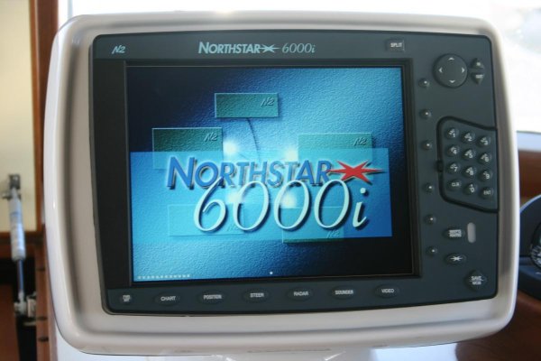
Part of my remorse for having to let my SeaHorse go is that my Northstar 6000i goes with it. What a great piece of equipment it is! Talk about user friendly....just push the button that houses the info you need and shazam, you're looking at it! I have an 8 year old Raymarine E120 MFD on the recently purchased boat and really have no idea what it's capable of. Oh, I'm sure it will probably do everything the Northstar does but I'm also sure it won't be as intuitive. "Northstar made great stuff." They sure did!... I have an old Northstar 957/8 on my on my boat, Northstar made great stuff back in the day..

Attachments
sunchaser
Guru
- Joined
- Apr 9, 2008
- Messages
- 10,196
- Location
- usa
- Vessel Name
- sunchaser V
- Vessel Make
- DeFever 48 (sold)
MaxSea has a navigation and planning mode. There is no difference other than turning on/off instruments. But to switch between the modes, you need to restart the program, and it takes forever to start up. That urks the techie in me. CE switches modes without a blink. .
Peter
Is this different than Nobeltec VNS? As we try to decide between Trident vs CE, this would be a good question to resolve. BTW, we've found pricing on CE to be about 1/2 as compared to Trident when taking into account all NA charts.
Insequent
Yes the NN3s are a great screen, cheaper than anything else out there and loaded with programs to boot. We could not find a better priced screen four years ago when upgrading.
sunchaser
Guru
- Joined
- Apr 9, 2008
- Messages
- 10,196
- Location
- usa
- Vessel Name
- sunchaser V
- Vessel Make
- DeFever 48 (sold)
Don't worry Walt, at least with the Altus you don't have a lower helm to add double the new gizmo fun too! Great layout and little used vessel it would appear.Part of my remorse for having to let my SeaHorse go is that my Northstar 6000i goes with it. What a great piece of equipment it is! Talk about user friendly....just push the button that houses the info you need and shazam, you're looking at it! I have an 8 year old Raymarine E120 MFD on the recently purchased boat and really have no idea what it's capable of. Oh, I'm sure it will probably do everything the Northstar does but I'm also sure it won't be as intuitive. "Northstar made great stuff." They sure did!
Codger2
Guru
- Joined
- Oct 11, 2007
- Messages
- 6,691
- Location
- US
- Vessel Name
- Circuit Breaker
- Vessel Make
- 2021..22' Duffy Cuddy cabin
You are right, Tom. It is a great layout and a huge fly bridge. My wife is more excited about this boat than I am.Great layout and little used vessel it would appear.
Attachments
OP
OP
twistedtree
Guru
Peter
Is this different than Nobeltec VNS? As we try to decide between Trident vs CE, this would be a good question to resolve. BTW, we've found pricing on CE to be about 1/2 as compared to Trident when taking into account all NA charts.
I'm not sure. I came into the fold with MaxSea Explorer, and don't know the Nobletec line prior to it's merger with MaxSea. All I know is that pre-MaxSea Nobetec owners love the product. But I also have heard a number who have come to dislike it as it becomes one with MaxSea. I think at the core the products are now one in the same.
Is anyone more familiar with how the Nobletec line has evolved and merged with MaxSea?
- Joined
- Mar 17, 2012
- Messages
- 4,279
- Location
- Australia
- Vessel Name
- Insequent
- Vessel Make
- Ocean Alexander 50 Mk I
Peter
For the last couple of versions, MaxSea and Nobletec are only distinguishable by logo names and some menu bar colours. Prior to adding radar module I had a good demo of MaxSea at a boat show and was surprised at the similarity. It has to have the same underlying kernels etc I seldom use 'Planning' mode in Australia as its main benefit to me was tides and currents for when you expected to arrive at rapids etc. But I think switching between Nav and Planning is no big deal now. I wont be near the boat for a few days so cant readily confirm that.
I suspect a lot has improved since your version. But I hear your comments.
One thing that hasn't changed much is pricing. I bought Trident as an upgrade from Nobletec in the US, it was just a new licence number and a download after payment was processed. In theory it should have been possible to do it in Australia as the distributor is only a few miles from my marina. But it was going to be more expensive. Europe pricing was even worse, go figure! As it was I also had to pay $500 for the Nobletec radar PlusPack about a year ago. Now its free.... I am not at all impressed by that as you would imagine. For MaxSea the radar module was always included at no cost.
If I am ever looking at a new system than clearly I should look at CE. It does get a lot of approval on the forum, and I would probably use mostly ComNav gear if starting out again, and like you are now, keep integration to a minimum.
Is anyone more familiar with how the Nobletec line has evolved and merged with MaxSea?
Both are licensees of ActiveCaptain. I have both products. I once had the original Nobeltec and VNS back when it was started by Dave Steckler who had the amazing idea of quilting together raster charts using Windows 95.
Nobeltec VNS no longer exists. It's not supported and is basically gone. Nobeltec Odyssey and Trident are essentially equivalents of MaxSea Navigator and Explorer. The software is nearly identical. Nobeltec has more support for non-Furuno radars but other than that, the software differences are cosmetic. MaxSea views Nobeltec as the US version of MaxSea.
The MaxSea/Nobeltec software is quite unique and is quite capable. It's the only product that I know of that heavily uses the GPU on PC's using OpenGL. Making use of the GPU alongside the CPU makes the magic of Time Zero happen - their brand for the super-smooth, super-realtime handling of charts in 2D and 3D. It's quite amazing. Come to Great Harbour in the Bahamas this winter - I'm giving demos of all of all the products.
The parent company of MaxSea is 49% owned by Furuno. That parent company owns MaxSea, Nobeltec, and MapMedia (the chart producer for Furuno and the MaxSea/Nobeltec products).
Rose Point was started by Brad Christian. He was an early employee of Microsoft and came up with an interesting word processing software product that became Microsoft Word. He was the lead developer and I understand the eventual product manager where he managed some 300 developers and empoyees through the big expansion times at Microsoft. As they went public, Brad must have had some stock. He left to go cruising. He eventually realized that no one was taking advantage of the latest Windows API's (XT?) for a chartplotter product. So he wrote it. That became Coastal Explorer.
Liking one or the other is usually based on what you're used to. They are both high-end navigation products and quite capable for any need any of us would have.
tpbrady
Guru
TT,
I started with Coastal Explorer almost 10 years ago on a 22 foot C-Dory when MFD's were just coming into general production and distribution. At that time I relegated a Lowrance chart plotter to primary duties as a sonar next to the dedicated radar display (Furuno 1623). I am on the third boat since then and have maintained that mixed configuration ever since. Over that time, I have tied CE to the NMEA 2000 network as well as into a NMEA multiplexer to get AIS data. I have seen little snippets of all the problems you mentioned in your blog but the ARPA one. My favorite one was trying to find the heading sensor that showed the vessel icon running 90 degrees to COG. A high traffic environment for us is all the charter boats heading back to Sitka in the afternoon so ARPA is high on my list to use. I have experimented with it, but it's labor intensive and the charter boats are fast enough relative to our speed where they are going is pretty obvious.
I kind of view the lineage of most MFDs as fish finders that morphed into chart plotters when GPS became available, added a radar input, and then networked them together. As log as I stick with the core function of device, sonar, everything seems to work pretty good. The chart plotter as far as I am concerned is a ready backup to CE that is generally not needed as long as I don't do something stupid. However, once these devices are networked then that is when the confusion starts. With CE I know which device is providing GPS input, and which device is inputting depth below the keel. However, on the chart plotters (one at both helms) I don't have a clue unless I plow into a few menus, and then it is liable to change and not tell me. MFDs are pretty good at core functions, so I think they have a place doing duty as a sonar and emergency backup chart plotter.
Tom
OP
OP
twistedtree
Guru
Heres a stupid question: what is a fish finder? I thought it was one of those hummingbird echosounder-ie things?
Jim
Sent from my iPad using Trawler Forum
It's just a fancier version of a depth sounder. Instead of just showing the bottom, a fish finder will show you the whole water column with blips of varying sizes for critters in the water column. It's like radar looking straight down below your boat. The view below your boat gets continuously plotted on a display so what you end up seeing is a view of the water column along your track. You can see giant bait balls of schooling fish, and larger fish moving around on their own. I watched a whale go under me once. You can also get a much better sense of the contour and make up of the bottom. They are pretty cool, and of course fisherman love them. I just like watching what's going on down there 'cause I think it's cool.
tpbrady
Guru
Jim,
I guess the fish finder has evolved from finding fish to being a good way of looking at bottom structure. While I use mine to find fish especially those suspended over rock pinnacles, I use it more to look at the bottom where I am going to anchor. Mine down to a depth of about 80 feet gives me pretty good resolution of things like individual rocks, logs, and sometimes cables. Many times while fishing, I can see 1 lb halibut weights going to the bottom and coming back up. A good sonar/fish finder is a piece of essential equipment on the bridge.
Tom
High Wire
Guru
I too am frustrated with the bugs in newer electronics and the attitude of some companies to solve the problem if it was not installed by a factory trained tech. Heres an example:
I bought a 21 CC to fish back in NJ. The PO spent big bucks at the time of purchase to install a Lowrance suite of chartplotter, radar, and fishfinder in a 12" top of the line at the time system. First, the pre-broadband radar is pure junk. Its one of those 12" domes. The main bang blots out 1/16 of a mile on 1/8 mile scale. That one huge blind spot. Everything is menu driven. Essential controls like range and gain are menu driven. Too many different button pushes to get where you need to be, then make the change, then back all the way out before you can make a different adjustment. You have to stop looking ahead to focus on pushing the right buttons. To replace the radar means replacement of the whole package.
The plotter worked great for 2 whole weeks. Perfect track, very stable speed and heading data. Then one day "GPS Module Not Responding" message comes up. Come to find out, the Lowrance LGC2000 GPS module has the worse failure rate out there. No problem, the new LGC4000 module has a great history and will fix you up for $199 plus an adapter cable, tax and shipping. Pay that, plug it in and within seconds, gps locked on. All is good until I left the dock. The new module is advertised to update 10X per second. The problem is with the older plotter can't handle it , the update is so fast that the boat rocking shows up as 1.5 kts one way, then a fraction of a second later 1.5 knots the other way. With the boat running at speed, every time the bow lifts for a wave, the heading reverses for a split second then resumes. No way it could ever drive an autopilot. Lowrance fix was to slow the module output down to 1X per second, but there still is no averaging or filtering and the heading still flips. Then the software fix killed the new LGC4000! Sent it back and they sent a replacement. Working again. The next suggested fix would be to buy the new Point 1 module which has a heading sensor for another $199. But that would not fix the jittering speed.
I also have a Hummingbird 798 CI HD SI. The side scan works great, but the GPS draws a 50 ft diameter birds nest track sitting in the dock. No fix but if I bought an external antenna and cable for about $200, supposedly that MIGHT fix it.
At this point, I've learned their bad behaviors and work around them.
tpbrady
Guru
Archie,
I've been around the tree with Lowrance and couple of times and after a conversation with them at the Seattle Boat Show last month, I think they are permanently off the list. I encountered the problem with the LGC-2000 on an older unit (it doesn't like marine radar anywhere close) and some of their menu structures are baffling at best and some don't work at all (never implemented).
One thing I have noticed on using internal GPS in chartplotters located in the cabin, is that you can't acquire the WAAS correction much of the time. When that happens the circular error of GPS goes from 10 feet or so to 30 feet or more. WAAS doesn't come from the GPS satellite constellation but from geosynchronous satellites at 98W, 107W, and 133W longitude. That's why an external antenna may be necessary. Being twice as far away and in a fixed location, your superstructure may be effectively blocking the WAAS signal, something they don't say much about in the owner's manual. On my boat, I slave my lower helm MFD to the GPS in the upper helm MFD as it gets WAAS most of the time.
Tom
Lollipop
Veteran Member
We have just moved up from an inland type houseboat to our first trawler. I have had boats most of my 61 years and can do most maintenance and repairs. We are going through every system on our NEW 1979 Prairie CC 36 with hopes to put it back in the water for a couple years of trouble free cruising. (I know, There is no such thing on a boat) During the refit, I had planned to replace all the electronics with the latest and greatest integrated systems. It had a Ratheone sl70 radar, Wood Freeman auto pilot, three depth sounders etc. Reading all this I am now questioning this decision. I have not read any comments, or seen anything on Garmin, the brand my local Marine store is trying to steer me toward.
Similar threads
- Replies
- 1
- Views
- 358
- Replies
- 68
- Views
- 5K
- Replies
- 5
- Views
- 1K
- Replies
- 13
- Views
- 1K