C-Map cards

The friendliest place on the web for anyone who enjoys boating.
If you have answers, please help by responding to the unanswered posts.

JackD

Veteran Member
Joined
Oct 27, 2013
Messages
83
Location
USA
Vessel Name
Big Fish
Vessel Make
Mainship Pilot 34
Rookie question - I just bought a boat from Chicago. Sold the C-Map card for the Lake Michigan on eBay. Bought another on eBay and now realize the one I bought is a different shape. They were both "NT+", but the original had more of a rectangular shape and this one is more square with a metal clip on it. See attached photo for similar images. I'm not near the boat to see if it fits, but I'm skeptical. Are not all C-Map NT+ cards created equal?

Thanks,
Jack D

Big Fish
Worton Creek, MD
Mainship Pilot 34
 

Attachments

  • Untitled.jpg
    Untitled.jpg
    139.8 KB · Views: 86
I know I'm not directly answering your question (Not sure). However, I'd be reluctant to buy them from e-bay. I know you can buy them from Jeppesen with a subscription service for updates. Having updated info would be the key there.
 
The shape of the C-map card will vary with what brand and model of GPS you have. C-maps have been used in quite a few different brands and models. If the card is not exactly the same shape as your previous card, it will probably not fit in the card slot on your unit. From the standpoint of a dealer, I always ascertain what brand and model I am ordering the C-map for, so the customer gets the correct format. Unfortunately it appears your new map might be for a different brand/model.
 
If you need the rectangular cards the square ones with the metal clip won't work...at least mine did not.

What you want is a C Card. The square ones are SD Cards

I got my last one from Jeppesen via Landfall Navigation. Their website lets you enter the machine you are buying it for and it will tell you what to buy.

Then you can go to ebay and buy the right one if you want to. Pay careful attention to the dates written on the cards from ebay. Too old might be badly out of date. A little old might be OK.
 
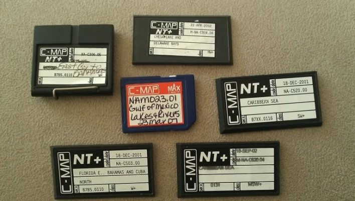
To simply affirm what the previous posters have said, C-Map cards vary with the era they were made and the equipment they are intended for. Our 1998 Echotech green-screen GPS plotter uses C-Map cards like the longer ones in your photo. Our newer Furuno NavNet VX2 C-Map radar/plotter uses C-Map SD cards like the smaller one in the middle of your photo.

Also, the SD card in your photo is a C-Map Max card. This is not the same data format as the older C-MapNT. The Max cards, as the name implies, show a much wider area with a single card as the NT cards. For example it takes eight C-MapNT cards to cover the area from the San Juan Islands to the north end of Vancouver Island and Cape Caution across from it on the mainland.

It takes just two C-Map Max SD cards to cover the area from the south end of Puget Sound all the way north to Yakutat, Alaska.

I believe, but I could be wrong. that the other card in your photo, the one with the metal clip, was the card type that preceded the rectangular NT cards in your photo. Either that or it is perhaps a card that was made for a very specific plotter. It's not an SD card.

But I think that in the late 90s/early 2000s, all or almost all the C-MapNT cards did indeed look like the longer ones in your photo and the plotter manufacturers all used the appropriate reader. For example not long after we got our big Echotec plotter we got a Magellen handheld GPS plotter that was also C-Map. Even though it was quite small, it used the same C-MapNT cards the Echotec did.

When the smaller but more data-capable SD cards became popular, the C-Map folks changed over to them and the manufacturers installed an SD card reader in their plotters. A few years ago we bought a Standard Horizon C-Map GPS plotter for one of our other boats and it, too, uses SD cards.

As others noted, the two kind of cards are not interchangeable in the readers.
 
Last edited:
I know I'm not directly answering your question (Not sure). However, I'd be reluctant to buy them from e-bay. I know you can buy them from Jeppesen with a subscription service for updates. Having updated info would be the key there.

It's worth re-reading the above.

I know lots of folks don't believe in using current charts (electronic or paper).

To help you decide, take a look at the WEEKLY Local Notice to Mariners publication for your area.

Read all the changes that were made to your charts this week.

It's a no-brainer for me. New charts at every opportunity. YMMV.
 
What plotter have you got? I have Standard Horizon and have a couple of C-Map cards, 2 of mine are the rectangle and are orange, 1 is NT + and the other is a Max. I also have a black one that came with a plotter I bought that is for the east coast looks like the 3 on lower right in your pic.
 
Back
Top Bottom