Current/fuel calculations

The friendliest place on the web for anyone who enjoys boating.
If you have answers, please help by responding to the unanswered posts.

jjanacek

Veteran Member
Joined
Jan 18, 2012
Messages
39
Location
USA
Vessel Name
Adirondack
Vessel Make
Monk 36
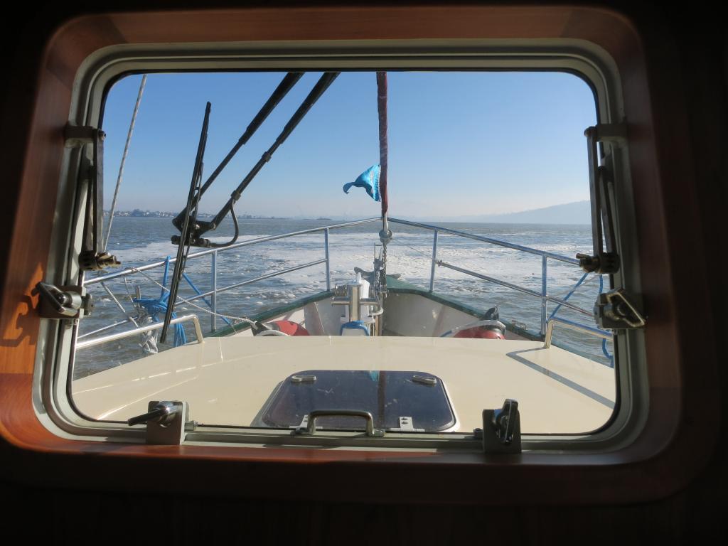
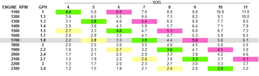
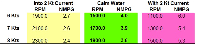
We operate between 1600 and 2000 rpm, usually around 1700. We used to think
we could figure out the tidal currents on the ICW for optimal fuel use, but
are fooled often, so I have a formula: when going against the current I use
a higher rpm, thinking I'm going upstream for a shorter length of time that
way, using less fuel. When traveling with the current, I slow down,
believing I'm letting the current do some of the work instead of my
Cummins. I'm sure I've saved at least four tablespoons of diesel over the
years with this method.

So why not have an application that would incorporate the tide tables,
current, time of day, date, speed and place to figure out the optimal time
to travel from A to B? Of course this would just be a guesstimate, but a
worthwhile project for someone and maybe worth a few bucks,

I'm sure this has been done for boats that travel on the high seas and
really use some diesel, but why not for other boats?

Jeff Janacek on Adirondack
at Hidden Harbor in Brunswick, GA
_________________________
 
Good idea. A few reasons why it hasn't happened:
It would have to be specific for your engine, trans and prop.
the ICW currents, with so many channels and outlets is too complex for the few current measuring devices out there.
If you can afford the boat, you shouldn't worry about fuel consumption (just joking!)
 
You post an interesting question that I wrested with but in a different way.

Traveling north on the ICW last summer there are several published trouble spots that got my attention. Calculating a departure time to be at these trouble spots at high tide was easy but trying to figure out the currents to make that arrival time good was difficult. I would be traveling at my normal 7.5 kts then 15 minutes later I would see 9 kts then 20 minutes later, 6 knots.
I had the ability to go fast so I felt that I could adjust speed as necessary to make good my arrival time at high tide.

But what I found out very quickly is there are so many inlets and so many advancing and retarding currents that they all just average out. I soon learned that if I calculated a departure time to arrive at high tide based on a 7.5 kt cruise, discarding the currents, that calculation worked pretty darn good.

Of course this only works with many advancing and retarding currents over a relatively short distance, say less than 75 miles.
 
Last edited by a moderator:
Coastal Explorer has such a feature, or at least in part. It's not going to calculate your fuel usage, but it will show your route timing taking currents into account.

Now I'm speaking a bit out of turn here, because I haven't used it myself. I've just followed the discussion on their support forum where people (me among them) were asking for it, and recently it was made available. They often have features that are available on a preview basis and you have to select an option to turn it on, knowing that it's still a bit experimental. But this discussion is a good prompt to go try it since I'm about to venture into the land of heavy currents and channels in the PNW.
 
Last edited by a moderator:
My strategy is to try to plan for long stretches where current is a factor, and ignore the short stretches. Lots of ICW jumps from inlet to inlet and current swaps somewhere in between. But long stretches you might be in a current for 20miles.

A case in point: Going from Georgetown SC back to Wilmington- Left just before peak of flood. Caught the favorable flood tide up the Waccamaw. Somewhere behind Myrtle Beach, started riding the ebb toward Little River Inlet. Then many hours later, caught the Cape Fear River in flood, got a boost there too. Those are three long stretches that really made a difference. Between Little River and Southport, it swapped back and forth several times.

Most other attempts at timing currents were abject failures. Currents lag tides, and the lag varies with geographical location, astronomical effects and even weather. I try to time a particular passage and end up being an hour or two off in when the swap occurs.

And yes, bucking a tide it is better to push a little harder, riding a tide better to pull back on the power. Taking an example to an absurd extreme: Say the current is 6kt and you have s 6kt boat. You will go nowhere against it, and can make 6kt with it with engine off.

I am fortunate that I can run 20kts if faced with an opposing current, get that crap overwith!!!

I doubt there is an app that could incorporate all that is needed to predict currents very well. I use Coastal Explorer and there is a feature there, but have not really tested it much.
 
With a six-knot boat often fighting two- and three-knot headcurrents, I enjoy finding counter-currents.


img_298488_0_3ac02bf499d7a87578d7c102bad96ac8.jpg
 
The longer you travel the less it will matter. Your going to gain and loose equally over time. If you have a schedule then there are certain times that are better for travel than others. One week may favor northbound during daylight hours. Next week will favor southbound. Best to prepare for all contingencies and deal with the cards as they fall. As ski pointed out sometimes it better to just stand there rather than do something.


Via iPhone.
 
What the OP wanted was a program, app or feature on a chart plotter that would tell him when it would be worthwhile (fuel burn wise) to speed up in an adverse current and slow down in a favorable current. Much of what has been said so far is about predicting currents along the way. The more difficult chore is to manage them appropriately and do something about them.

I don't think he will see such a program any time soon. Several reasons:

1. Most people don't care. They set their throttle and stick to it.

2. Different boats and engines have different fuel consumption curves.

3. As others have said there are many places along the ICW where you would be changing your speed every 15 minutes to optimize the current. In some places it changes every 10 miles as you approach or leave an inlet.

And finally you can do it yourself fairly easily- the brain is a much better processor of that kind of problem. Look at your speed through the water vs GPS speed over land. You have to first calibrate these closely. Every time you see about a knot difference, then speed up or slow down a little. If the current difference increases then increase or decrease the speed some more.

Do the calculations yourself to see how much to speed up or slow down and how much fuel you might save. After a while it will become intuitively automatic I suspect.

I have done this once or twice but never routinely.

David
 
Twistedtree,

I worked with that feature in Coastal Explorer last summer and it seemed to be pretty good in predicting accurate arrival times at waypoints and the final destination. However it only dealt in predictions and not the actual tidal current encountered. It would tell you when to leave to have the least time in route to a location. If least time translates into less fuel used based on a strict GPH calculation it sort of does it. However the basic question of whether to speed up going into a tide or slowing down with a tide, is almost purely situational where we boat in southeast Alaska. If I am running with a tide, my speed is dictated by how far it is to the best place to be when the tide turns or do I really want to be out here when the tide turns and is going against the wind. I think the OP is asking a question that will take us into the realm of artificial intelligence. At a minimum it will be a great mathematics exercise for a high school student.

Tom
 
On old piston aircraft a headwind would see a 10% POWER INCREASE , A TAIL WIND A 10% reduction for long distance over water.

Bumping up the rpm 200 or so and pulling back the same would be EZ on the ICW where day markers are like a picket fence so watching the current is possible.

A GPS might help in figuring the extra RPM.

But I think doing nothing but enjoying the scenery is probably worth the tea cup you might save in a seasonal transit.
 
Tidal currents aren't "known" for every inch of the ICW and even if they were predicted for every inch, environmental conditions can vary them significantly enough to throw off any calculations based on predictions alone.

The same wind conditions are causing a slight surface current and possibly affecting your speed with windage (very noticeable on my boat)....further reducing computer program accuracy.

The best method I can think of to use is an accurate fuel burn gauge with GPS input to give instantaneous GPM.....figure your best and adjust throttle to keep it close....if you care that much to ultimately be guessing on a small percentage of fuel use.

Overall you may develop some averages for into or following currents, and after thousands of miles you may find your best fuel burn for a reasonable speed....but I will bet that most of us are in that range anyhow just from listening to others and "feeling" our own boats.
 
So why not have an application that would incorporate the tide tables,

current, time of day, date, speed and place to figure out the optimal time

to travel from A to B?


_________________________


Jeff,

from a pure mathematical point of view we need to know what your criteria for "optimum" is. And the answer to that question isn't simple e.g. if it's "fuel consumption to be a minimum" you should stop your engine if going with the tide - regardless how long it will take to your destination...

From a practical point of view: We avoid if ever possible to run against the tide (on the Elbe), it can be so frustrating if you are traveling with a full displacement hull...


best regards / med venlig hilsen
wadden
 
I agree with Psneeld. You need a very accurate instant fuel burn flow meter, such as a FloScan, to complete the equation. Once you know your GPH fuel burn at various power settings, the rest is simple math that can be charted in a table for quick reference on the boat. If you have the electronics to take the FF input and compute NMPG based upon GPS SOG, you'd always have an instant digital readout. But we don't have that, so we can make a chart. You don't need an app for that.

Let's take a hypothetical boat that runs at 7.0 Kts at 1700 RPM. Here is a chart of our boat, the Canardly Stayafloat.

img_299237_0_e0fa1864892838b7a479f38ef04a9071.jpg


The engine RPM/Fuel Flow values are fixed values that do not change for our trusty boat. Set the throttle to 1700 RPM and you'll always burn 1.8 GPH. Our still water performance is represented with the green cells. 1500RPM/1.5 GPH gives us an even 6 kts at 4.0 NMPG, but we find that too slow. When we bump the power to 1700RPM/1.8 GPH, we get 7 Kts at 3.9 NMPG. Bump the power further to 1900 RPM and we get 8 Kts and 3.6 NMPG but that's too inefficient for our taste so we settle for a standard power in this boat of 1700 RPM.

Each of these chart NMPG values is simply the SOG in Kts divided by the GPH for that given engine RPM. As we cruise into the current, our speeds slow and our NMPG values shift to the left. As we cruise with the current, our SOG increases for any given engine RPM/FF pair and the NMPG readings shift to the right on the chart. The yellow and pink boxes represent a 2 kt current working against us (yellow) and pushing with us (pink).

If we leave the power fixed at 1700 RPM while cruising into varying currents, it's simple to see that our efficiency (NMPG) drops into the current and increases when moving with the current. Assuming a 2 kt current, we go from 7 Kts/3.9 NMPG in calm water to 5 Kts/2.8 NMPG in 2 Kts of water on the bow (yellow cell at 1700 RPM) and 9 Kts/5.0 NMPG with 2 kts of current pushing us along (Pink cell at 1700 RPM).

These are the numbers we have to beat to make all this power jockeying worthwhile.

So let's look at varying the power to maintain fixed speeds in varying currents. The numbers below were just plucked off the chart shown above and organized for clarity.

img_299237_1_d4abcdff6ac623846233844334c6efed.jpg


I can see that on this boat as I increase my engine RPM while travelling into the 2 Kt current, my efficiency drops from my 1700 RPM efficiency of 2.8 NMPG. So with this boat, you wouldn't be helping your efficiency by increasing power into the current, but, of course, you'll get there a little sooner.

When moving with the current, I can see incremental improvement in efficiency as I reduce the power. My NMPG increases to 6.0 if I want to go as slow as 6 kts at near idle power. :nonono:

So with this Canardly Stayafloat, I'd be tempted to just leave the power at my normal cruise setting of 1700 RPM and accept the varying speeds. But every boat/engine/prop combination is going to have its own 'pocket' in which it likes to run. Of course, YMMV!
 
Tidal currents aren't "known" for every inch of the ICW and even if they were predicted for every inch, environmental conditions can vary them significantly enough to throw off any calculations based on predictions alone.

The same wind conditions are causing a slight surface current and possibly affecting your speed with windage (very noticeable on my boat)....further reducing computer program accuracy.

The best method I can think of to use is an accurate fuel burn gauge with GPS input to give instantaneous GPM.....figure your best and adjust throttle to keep it close....if you care that much to ultimately be guessing on a small percentage of fuel use.

Overall you may develop some averages for into or following currents, and after thousands of miles you may find your best fuel burn for a reasonable speed....but I will bet that most of us are in that range anyhow just from listening to others and "feeling" our own boats.

:thumb:
You are David are spot on, but there is one more fly in the ointment.

Even if all the currents were known for every mile of the ICW, the currents vary greatly from inside and outside the curve of every curve. And then what makes it ever more interesting, is that while the current is fastest on the outside of the curve and therefore the water is deeper, each boat handles it differently depending on its draft and how it reacts to the bottom.
 
:thumb:

Even if all the currents were known for every mile of the ICW, the currents vary greatly from inside and outside the curve of every curve. And then what makes it ever more interesting, is that while the current is fastest on the outside of the curve and therefore the water is deeper, each boat handles it differently depending on its draft and how it reacts to the bottom.

My NMPG goes to crap if my boat rubs it's bottom on the channel bottom!!
 
:thumb:
You are David are spot on, but there is one more fly in the ointment.

Even if all the currents were known for every mile of the ICW, the currents vary greatly from inside and outside the curve of every curve. And then what makes it ever more interesting, is that while the current is fastest on the outside of the curve and therefore the water is deeper, each boat handles it differently depending on its draft and how it reacts to the bottom.
That's why I said every inch of the ICW....me and the Cape Fear river are arch rivals when I am headed north...there are a couple other rivers too that I tend to zig zag if I'm bucking an ebb...:D
 
Actually, you can make it all work for you, some, if you are in no particular hurry to get to a particular place at a particular time. The simplest method is time your arrival at the inlet intersection for slack before the current that will push you up the other side. At the very least, the water will be calmer. (Almost by default, but surprisingly not always, you will have some push on the way too the inlet depending on configuration. Also ebbs tend to be stronger than floods). I used to make a game of it, just for sport in nothing else, though there are plenty of inlets, even at crossings, where you do not want to there at max ebb.
 
I just built a mathematical model (read simple Excel spreadsheet) based on fuel consumption of my boat, and here is what I learned. As long as the current/tide or whatever you are running into is less than 1/2 than the SOG in calm water at a cruise rpm then going faster only increases total fuel used over any distance. Once the current exceeds more than 1/2 the SOG in calm water you can increase RPM to increase SOG up until you start trying to climb your bow wave and you will burn less fuel over any distance. When running with the tide or current, slowing down always reduces the fuel used over any distance. Speeding up always increases it.

So Jeff's hypothesis would seem to be true if you are going into a current that is more than 1/2 your SOG in calm water. Of course I may be wrong, but I generally try to avoid 3 knot tides anyway.

Tom
 
Tom

I have found the currents in your area very difficult to predict. No matter how much I try to time things to gain time, I get flummoxed. Four years ago a group doing a predcited log cruise from Seattle found the same to true. I'll look you up this summer and get a tutorial.
 
Sunchaser,

Do that. We'll be somewhere between the Canadian border and Cape Spencer. Shoot me an email when you get in the area. We haven't laid out our itinerary yet but plan to get started toward the end of April. The only thing definite is we will be back in Wrangell for the 4th of July. It's the best fireworks display in Alaska.

Tom
 
The higher fuel burn at higher RPM in adverse current will make the duration shorter.

So the extra GPH must be viewed with the shorter run time to find weather the total fuel consumption at higher speed is worthwhile.
 
Like I mentioned previously, it all seems to wash if you travel long enough. Many times you won't even have to travel for the duration of a complete tide cycle. By example the area where our boat is currently kept, incoming tides create currents which run north in one section of the bay and south in another section. After roughly six hours they reverse. This happens over an 8 mile stretch of water, so it's possible to have fair, foul or split currents for the whole stretch (1 hour) and this is not unique. We saw it last summer on many stretches of the icw along the east coast.We have electronic diesels which accurately report and record all fuel use over an n2k network tied into a sat compass and navnet (think instantaneous nmpg data ie the holy grail of info,apparently). We also have a laptop running software which shares this data over the net. So what do with all this info? Ignore it mostly, as we run the boat by ear and feel. Now there are certainly some areas that are notorious for fast tidal currents and for those we look to time things in our favor as best we can, but even then there have been more than enough surprises. Then there are those areas where there are no tide stations and you need to make your own tables, sorry no app for that. Over the last 2 years this instantaneous nmpg number has spanned such a large range it has proven itself to be pretty worthless (hear that Oliver? Your dad understands) and we simply take our total mileage travelled and divide it by our total fuel use. That number encompasses all types and strengths of weather and currents. Since for us, the trip IS the destination, we just try to enjoy it, no matter what it is costing for any particular mile. One more thing, we have found that on our boat, a foul bottom costs way more than any foul current has.


Via iPad using Trawler Forum
 
That's why I said every inch of the ICW....me and the Cape Fear river are arch rivals when I am headed north...there are a couple other rivers too that I tend to zig zag if I'm bucking an ebb...:D

I also discovered this past year that when steering by hand, many times, I can let go of the wheel and Dauntless will stay in the deeper channel, even as the river meanders.

I discovered this the hard way as i realized I was over controlling and forcing her into too shallow waters, even though the markers indicated a wider channel.
 
I have recalculated our rpm-speed-fuel curves for the case "running against current", i.e. subtracted different figures (0-7 knots) for the current from the speed curve to get the SOG and calculated the nmpg (please remark that I have converted the data to your US units :) based on the SOG and the fuel consumption at given rpm according to our files:
ImageUploadedByTrawler Forum1421434332.157519.jpg
(continuous lines indicating SOG, dash dotted lines nmpg)

Starting at 3 knots head current there seems to be an optimum rpm for our boat giving the best range out of a certain amount of fuel. This optimum rpm is shifting to higher figures the higher the current flows against us. The red dash-dot-dotted line is indicating those points of maximized range.

However - as nice such diagrams are looking to engineers like me I am afraid that this particular one is of very limited practical relevance.
Up to now we have been able to avoid currents above 5 knots against us. And we never run our Lehmans continuously below 1300 rpm as it would give the best milage below 5 knots of current.
In most cases we just continued our journey against a current with the throttle setting we have had before...


best regards / med venlig hilsen
wadden
 
Well, it looks like 3 members and engineers, tpbrady, waddenkruiser and me, ran our own independent analyses and came to the same conclusions regarding fuel saving practices. I like how tpbrady summed it up in post #18.

"As long as the current/tide or whatever you are running into is less than 1/2 than the SOG in calm water at a cruise rpm then going faster only increases total fuel used over any distance. Once the current exceeds more than 1/2 the SOG in calm water you can increase RPM to increase SOG up until you start trying to climb your bow wave and you will burn less fuel over any distance.

When running with the tide or current, slowing down always reduces the fuel used over any distance. Speeding up always increases it. "


Now if we could only get some reliable current prediction models for all waters! Our models out west seem to be as error prone as yours' on the east coast.
 
Al,

I was a forestry major who spent the last 43 years in telecommunications. You might say I am unencumbered by formal training in what I do.

Tom
 
The OP question has some bearing on a problem I've thought about concerning the currents effect on fuel use. On the pool of the Mississippi River where I boat the difference in sog going with the current vs against is 5 mph. I've checked it several times when out for a Sunday cruise, never touch the throttles just turn the boat 180. I want to check my gph over a long distance cruise against the current this year. Over the last 5 years the average is 3.1 gph including gen time, but this is all 50/50 with and against the current. I've thought about taking a cruise to Memphis and with the lack of fuel stops having a known burn rate for 300 or so miles against the current will help with planning. If I remember right it's 265 miles from Memphis to the 1st fuel stop going upriver, I hold 304 gallons and think I should be able to make it, my average mpg over 5 years is 1.8, in case I have any doubt I have a 75 gallon bladder.
 
Ron,
I don't know if I've got you right but you can calculate the mpg for the upriver tour from your average mpg going up and down the river (with the same throttle i.e. same velocity through the water):
MPGup = 0.5 x (1 + SOGup / SOGdown) x MPGavg
Don't know your typical SOGs. For SOGup = 5 knots and SOGdown = 10 knots your average MPGavg = 1.8 mpg will reduce to MPGup = 1.35 mpg.


best regards / med venlig hilsen
wadden
 
Thank you very much, I was hopeful that I could get 1 to 1.2 mpg against the current.
 

Latest posts

Back
Top Bottom