Charts on tablet, pc, laptop or LCD off chartplotter

The friendliest place on the web for anyone who enjoys boating.
If you have answers, please help by responding to the unanswered posts.

Autoteacher

Senior Member
Joined
Oct 25, 2013
Messages
165
Location
USA
Vessel Name
Paradox
Vessel Make
Mainship
What works for you? Need to have larger display for vision. Have a Garmin 740S. Can we add a program, app or software that can be viewed as a chart plotter on a larger screen, LCD display or ? Needs to be real time like chart card in my garmin not from cell or satellite.

Thanks S.
 
I am using the Navionics app on my Samsung tablet. Love it!
 
Garmin Blue Charts on an iPad.
 
Well here goes.......I collected too many Apps when they first started coming out to see which was better. My choice is Nobeltec on (1).PC or (2).Ipad.

PC:
Nobeltec Time Zero Odyssey on Dell PC Windows 8, Lower helm.
Nobeltec VNS 10 on Panasonic Toughbook with built in gps, Windows XP Upper helm.

Ipad:
Nobeltec TZ App
Garmin BlueChart
Navionics
Navimatics
Plan2Nav

Use Nobeltec on both PC's and TZ App pretty much exclusively for navigation. A nice program is Splashtop, it allows the PC navigation programs to be displayed and manipulate on the Ipad screen thru the boats wifi network.....:blush:
 
Last edited:
Free is good for me and I prefer looking at a raster nautical chart over any vector chart.

Someday the vectors may become a quantum leap over rasters, but I haven't seen that yet.

So my vote is Open CNN on a laptop.

For a flying bridge, it is a toss up whether going with a dedicated marine product is better.
 
Some fly bridges , like mine, don't have room for a pc. And trying to balance a PC whilst doing 18 kts, mmmm, that would be a challenge.
 
Last edited:
What works for you? Need to have larger display for vision. Have a Garmin 740S. Can we add a program, app or software that can be viewed as a chart plotter on a larger screen, LCD display or ? Needs to be real time like chart card in my garmin not from cell or satellite.

Thanks S.


A search here will turn up several threads on the topic.

Plan2Nav, MX Mariner apps on tablets, MaxSea Time Zero on a laptop or iPad, etc.

-Chris
 
Well here goes.......I collected too many Apps when they first started coming out to see which was better. My choice is Nobeltec on (1).PC or (2).Ipad.

PC:
Nobeltec Time Zero Odyssey on Dell PC Windows 8, Lower helm.
Nobeltec VNS 10 on Panasonic Toughbook with built in gps, Windows XP Upper helm.

Ipad:
Nobeltec TZ App
Garmin BlueChart
Navionics
Navimatics
Plan2Nav

Use Nobeltec on both PC's and TZ App pretty much exclusively for navigation. A nice program is Splashtop, it allows the PC navigation programs to be displayed and manipulate on the Ipad screen thru the boats wifi network.....:blush:

The nice thing about the Nobeltec products is both Raster and vector charts. Vector are more accurate . The nice thing about the vectors is the ability to layer detail as needed. It does take some getting used too.
 
The nice thing about the Nobeltec products is both Raster and vector charts. Vector are more accurate . The nice thing about the vectors is the ability to layer detail as needed. It does take some getting used too.

Yes but I am "old" school and love Raster, can't get my head around looking at Vector. Guess I should use them more often and get with the new look.....:facepalm:
 
10624066_365497670294253_6630170988889932746_o.jpg


10687991_365497603627593_1598719346098873118_o.jpg


I like to run Open CPN on a cheapo netbook because:

1)power consumption is low
2)hardware purchase is super cheap now that everyone wants a super fancy tablet
3)HDMI output can go to pretty much any type of monitor
4)display on larger TV
5)going to flybridge? unplug and go upstairs
6)stolen...ok, go buy another one
7)doubles as fully functioning PC
8)can overlay additional information if you buy N2K components

I eventually would like to have the netbook above my helm where all the current electronics are. Take the current electronics and hang them up top. Keep TV screen where it is. If I install a wifi router on board, I can then dial my iPad up to simply display what is onscreen of the netbook. Then I can take that wherever I want. No special programming, no fancy purchases, no high dollar components that lose value instantly, etc. :thumb:

Then again we are talking a 79' Mainship so this is light speed ahead in terms of value:rofl:
 
We WAY prefer vector charts to raster. Raster are simply pictures of charts. Zoom them up, they get less sharp. Vector are razor sharp no matter how much you zoom in. They have layers you can turn off or on depending on what you want you see and the information you want to have. The text layers are separate from the chart layers so the charts can be oriented any way one likes and the text will always be right side up.

If we had to operate our three boats with raster charts it would be taking a giant step backwards in our view.
 
Last edited:
Yes but I am "old" school and love Raster, can't get my head around looking at Vector. Guess I should use them more often and get with the new look.....:facepalm:

I had the same "learning curve." I still use raster mainly for shipping channels and entrances, but have grown used to the vector charts when out in open waters. Maybe I'll continue to shift, we'll see.

To answer the original question, besides the Simrad chart plotters built in, we use an iPad with the Garmin app (and Active Captain) together with a laptop with Nobeltec (with AIS and GPS routed it).

I know the Nobeltec has a larger entry cost, but I think it is a remarkable product. On the other hand if we were only cruising locally, I don't think it is necessary.
 
We WAY prefer vector charts to raster. Raster are simply pictures of charts. Zoom them up, they get less sharp. Vector are razor sharp no matter how much you zoom in.

Yes, and this is part of the reason I prefer the raster charts for channels, entrances, etc. On the vector charts you can easily zoom in past the accuracy of the data.
 
We WAY prefer vector charts to raster. Raster are simply pictures of charts. Zoom them up, they get less sharp. Vector are razor sharp no matter how much you zoom in. They have layers you can turn off or on depending on what you want you see and the information you want to have. The text layers are separate from the chart layers so the charts can be oriented any way one likes and the text will always be right side up.

If we had to operate our three boats with raster charts it would be taking a giant step backwards in our view.


I feel the same exact way. Maybe because I'm younger and grew up using vector.
 
OpenCPN running on a CubieTruck and connected to the mounted [STRIKE]42"[/STRIKE] 32" LCD TV.

If we were ever to start cruising for longer term (we do weekends and daytrips 99% of the time) then I'd replace the 42" with a smaller more power efficient TV. Even something in the 22" range will normally consume ~40 Watts. This one is higher than that, and even more wasteful as it runs off a dedicated inverter.

20141005_175023.jpg
 
Last edited:
Yes, and this is part of the reason I prefer the raster charts for channels, entrances, etc. On the vector charts you can easily zoom in past the accuracy of the data.

I guess it depends an the quality of the vector chart. We have never experienced zooming in past the accuracy of the data (all of our plotters use C-Map). When we are in our marina and we zoom all the way in we see our boat sitting in our side of our slip. We routinely navigate passes that are less than 100 yards wide. Zooming in all the way does not eliminate detail, it simply blows the detail up larger on the screen. And that detail is every bit as sharp as it is when the display is zoomed out. And the lettering on the display stays the same nice, readable size regardless how tight or loose one is zoomed in on the chart.

A nice thing that can be done with the layered vector charts and that our new and newer plotters have is the ability to have all the lighted navaids on the chart light up. So if the lighted red buoy at the entrance to our marina has a one-long, two-short flash pattern, that's what it does on the chart display, too. Lighthouse patterns are there, as well. We don't run at night, but if we did this could be a very useful feature. And if one doesn't want it on for some reason, it's a menu selection to turn the lights off.

Based on our experience with vector charts in all our plotters (Furuno, Standard Horizon, and Echotec) I cannot fathom why one would want to use a pixel-based chart display that gets blurry when expanded, that makes words fuzzy and too big, etc.

To me, the difference is like comparing 4K High Definition video to the 525-line standard def video of the 1980s.

PS- Another great ability of vector charts is the overlay of real-time current data. This is particularly useful in this area with its wide current range and associated strong currents. On the Furuno on our PNW cruiser (the Echoec plotter, while vector, is too old to have this feature) current direction and speed data is only layered over the places where it can be important. So mainly the narrower passes through the islands and the channels that experience strong currents. There will be an arrow showing the direction and a number showing the speed, both tied to the current time of day. Not a substitute for a proper current guide, but a very useful feature at times.
 
Last edited:
In unfamiliar areas I run one screen showing a large area and use the iPad to get in close to follow a track and see everything the chart will show, I use Garmin BlueChart Mobil on my iPad. The Standard Horizon cp590 at the lower helm will split the screen to do the same.
 
I just bought a Chromecast device for my 42" flatscreen. Now, using my andriod phone and the Furuno app, I can display my electronics on the big screen while lounging in the salon.

I just hollar up to the wife in the pilothouse when I feel the need to correct her driving!
 
Marin,
If we ever meet and you're running my boat, i want you looking at vector charts. I entirely understand you are more comfortable with them. For me, I would rather look at a raster chart if i was traversing that 100 ft wide area, and then concentrate more on what my depth under the keel is and where the boat is. If i was doing it at night, rather than a chart with blinking marks, I'll rely on the radar to show me where they are in relation to us. Just my comfort level.

I think it boils down to sometimes I would rather have less options and settings on viewing my chart actually. Keep it simple, and don't distract me with options and settings I guess.
 
Well, everyone has their own preferences and what they are comfortable with. To me, the advantages and flexibility of vector charts are so glaringly obvious that to be honest I didn't think anyone even supplied raster charts these days until this thread. Nobody I know personally who uses a plotter on their boat has raster chart displays. I have for years now assumed they had gone the way of eight track cassettes.:)

In narrow passes, unfamiliar harbor approaches, etc., the vector plotters give us outstanding clarity of detail no matter how zoomed in or out we are, while the depth sounder and radar continue to be the same valuable tools they've always been. For us, navigation is a matter of using all the systems available to us just as it is in a plane, rather than focusing on just one system. So when we are in fog, for example, we are actively using both plotters (with different displays on each one), the compass, the radar, the depth/speed display, the intercom, the horn, our eyes and our ears. But not the bell.:)

When we are navigating in good visibility, nothing changes other than we don't have the intercom on, we aren't using the horn, and we don't give the radar as much attention as we do when the visibility is poor or nonexistant.

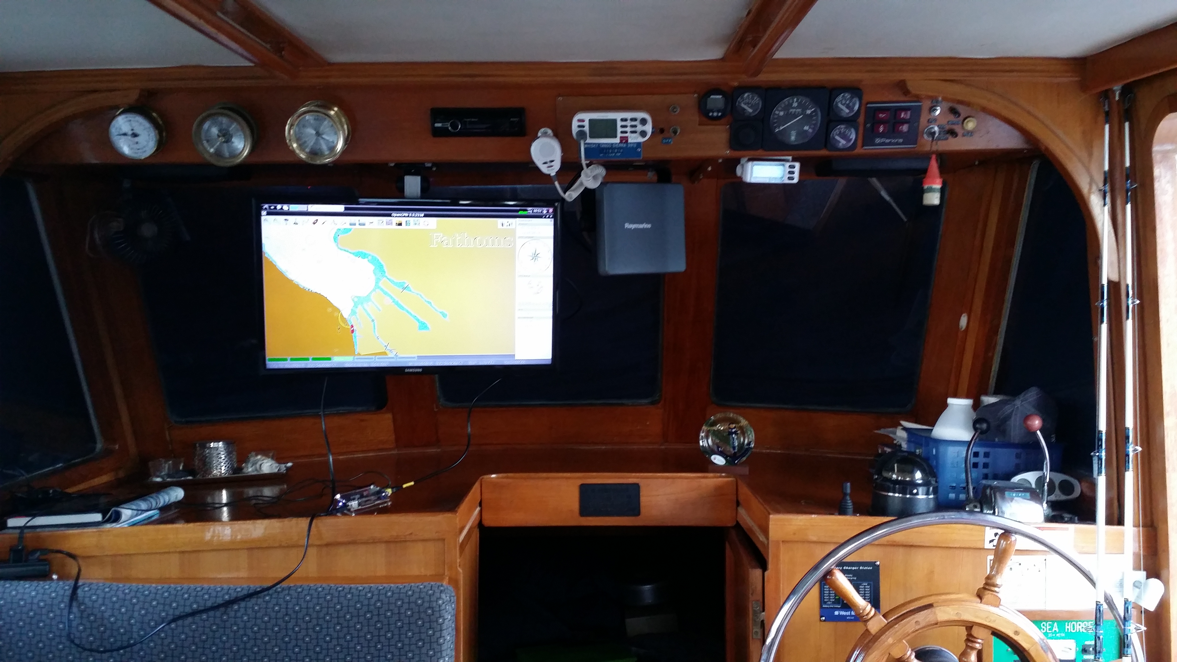
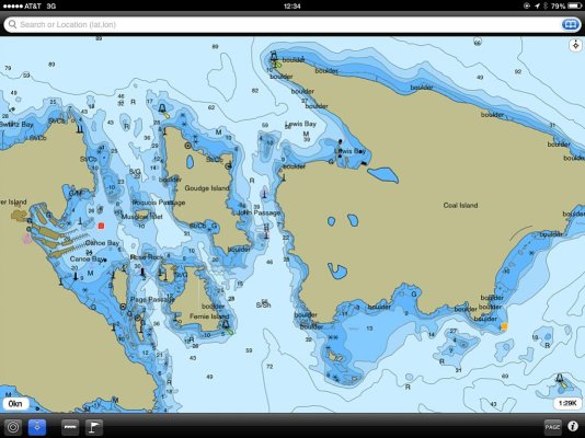
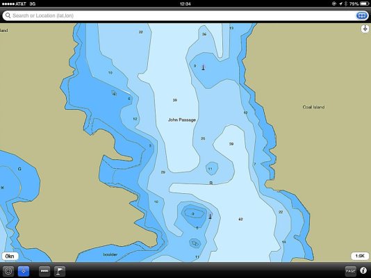
Below is an example of what I'm talking about with regard to what I believe is the superiority of vector displays. These screen shots were just taken off my iPad 2 using a charting application called Navimatics. This is not a plotter app but a chart app. While not nearly as detailed as the displays on the big plotters on the boats, and the iPod 2 is not as sharp as the displays on the plotters, they are still vector charts and so will serve as illustrations. I have no idea who creates the vector charts for Navimatics.

The charts show a narrow, dogleg passage between a pair of islands in lower BC near Sidney. This passage averages 170 yards wide and has shallow, rocky ledges all over the place, lots of kelp, etc. It also gets very strong tidal currents running through it. The upside is that it shortens the time it takes to get from the one side of the islands to the other; the alternative is to run around them. But it's critical to follow the right path through the pass, and this can be made fairly challenging when the current is running. We've been through it several times and it's always an interesting experience.

The first screen shot shows an overview of the passage. The second shot is zoomed in as far as Navimatics will go on where the dogleg course changes have to be made. The chart plotters on the boats will go in much tighter than this if one wants to, with no loss of detail or clarity.

I cannot imagine driving a boat through this kind of terrain with anything less than the clarity and flexibility of a vector plotter. And as described earlier, on our newer plotters any lighted navaids will portray the actual light color and flash pattern if that's of value, and in this particular passage, the direction and speed of the current through here is displayed in real time.

Again, these are iPad screen shots from a charting app. They are not shots of the display on one of our plotters.
 

Attachments

  • Vector EG1.jpg
    Vector EG1.jpg
    115.3 KB · Views: 139
  • Vector EG2a.jpg
    Vector EG2a.jpg
    71.4 KB · Views: 126
Last edited:
Oh great, Now I feel old too :)

Guess I better spend a bit less time alphabetizing my 8-track collection this winter and I'll play around with vector charts more.
 
What about the 45s?
 
I'm with Marin on this one.
Having been at sea for over 40 years and using chart plotters for the last 20 I haven't had a raster chart ever. Always hated they way they blew up when zooming in.
Always vector , accuracy has never been a problem and I travel thru the uncharted (virtually) Great Barrier Reef all the time.

My new Garmin system radar overlay and all is terrific but i do miss my Nobeltec and will probably get it back up as a standby unit. I run this via a very small footprint fanless computer ( Compulab Intense ) but may transfer it to a dedicated laptop to make it more portable.
I also want it back as so far I have not been able to transfer all my old fishing and anchorage marks over to the Garmin system
 
Last edited:
Marin got it right. I've been running PC navigation for 12 years. I've always run vector chart's. I can't see why anyone would want to use raster.

Sent from my Nexus 4 using Trawler
 
I think it boils down to personal preference and hardware. I have no issues with raster because I'm not viewing it on a 7" screen. I think whatever chart gives the captain enough information to navigate safely and effectively works, everything else is just bragging rights. Running a vector chart plotter with a raster backup on a laptop is a pretty good setup.


Just think, 15 years ago all you had was a set of coordinates in front of you on a 4 color display. I go from blip A to blip B and use a paper map to make sure there is nothing in between them. It's all relative :)
 
I use OpenCPN on an old cheapo laptop (a discard from work - too old to run current software fast enough). More than capable for OpenCPN.

I have both vector and rastor charts loaded - in some cases the rastor ones are better - dependent on location. Most cases I use the vector. Open CPN lets you toggle between them.

I also run a touchscreen monitor - a restaurant POS station (ELO brand) so is it somewhat splash resistant. Purchased off eBay for under $100. Most of the functions one uses when underway can be run via the touchescreen so the laptop is out of the way. Dimming for night running is fine.

I have AIS connected to the laptop via simple USB with AIS targets via OpenCPN. Works well and a highly recommended.

I also have an iPad with Navionics for backup, which works well. Too bright for night-time use though even when dimmed down as far as possible.
 
Back
Top Bottom