ICW- Your Best Tips

The friendliest place on the web for anyone who enjoys boating.
If you have answers, please help by responding to the unanswered posts.
True indeed (you should have listened to him ;o) !), though he also had a tendency to dole out some bad advice, the worst of all emphatically telling newbies they should not bother cruising New England! And some not very practical advice, such as always anchoring with two anchors off the bow. I'd still recommend his "cruising on a budget" book for a reference, but not a Bible.

It's that way with many writers, especially boating. They all have their prejudices, so great to read but don't take as gospel. In some ways even worse than an online forum because no one there to call them out on it.

I love Captain John's great loop site but sure don't agree with him on boat choice although many here might.

And those taking David Pascoe's reviews as gospel. Sorry, but they're more what he'd like than completely objective. Read them but filter them. It's actually enjoyable for me to get use to specific reviewers and know their preferences which will always find their way in.

But much to be gained by reading a wide selection.
 
When we went by the first green daymark on our starboard side

See, that is what I can't remember. Was/is that marker an actual day marker on a pole with a square wood panel or a floating green square top buoy?

I've been through there several times but it's been years so I don't recall what type of markers they are.

Wish some one had a picture. :)
 
See, that is what I can't remember. Was/is that marker an actual day marker on a pole with a square wood panel or a floating green square top buoy?

I've been through there several times but it's been years so I don't recall what type of markers they are.

Wish some one had a picture. :)

Yeah, it's a square green day mark with a gold triangle on it. I guess that is a little esoteric piece of info that can come in handy . Just like why you never run to an equal interval light.

On thinking the reason for this, when back lighted it is hard to tell the color of a marker. If a green were triangular it could be taken for a red.
 
Last edited:
This is the chart book I use. Convenient size, easy to flip pages. As you read ahead each day and learn of trouble spots put a notated yellow sticky note next to the area.

The Intracostal Waterway Chart book: Norfolk, Virginia, to Miami, Florida

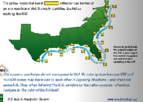
Right on about the red being on the land side. That is true in all but a few places such as the Cape Fear River. The big things to look for are the gold triangles and squares denoting the ICW markers. The gold never changes sides. The gold triangle is always the land side no matter if it is on red or green.

http://www.amazon.com/s/ref=nb_sb_noss?url=search-alias=aps&field-keywords=9780071545792

A lot cheaper on Amazon!
 
I too remember the markers changing sides in Panama City by St. Andrews. I managed that just fine but then in a moment (or more) lacking lucidity, I decided to "cut the corner" when heading into Pearl Bayou for a stopover. All was well as I headed in (not thinking about moon being full so the tide was lower than normal) but the real kick was forgetting that because I was no longer in the main channel the markers swapped sides.

Oops.
Fortunately I wasn't going fast and it was a rising tide so I could pretend I meant to stop there for a bit. And about an hour later the tide came in enough for me to get across and into the channel.

Seaweed didn't lean -- and I tried to put in a Hazard into Active Captain as a 'head's up' but it was rejected. I guess everyone else is smarter than I was that day.

Anyway, if you do decide to go into Pearl Bayou (under the flight pattern for Tyndale Air Force base) don't forget to watch those markers. And have a nice fly-boys movie to watch on the DVD player too.

It was a nice spot. There was an Island Packet anchored near me too. a double cabin (Chris Craft?) couldn't get their (inadequately sized/all rope rode) anchor to hold.

Not sure why anybody would head out on boat into unfamiliar waters without studying and having a paper chart close by. Before I go anywhere, familiar or not, I study the chart of the area I'll be cruising. I have too much time and money invested in my boat to take that risk. In addition, I check tides. FYI, all inlets and shipping channels have red on right on return. This means if you are traveling north and you enter a shipping lane/inlet and the aicw follows this channel for a while, the reds will be on the starboard side and once you exit and are only traveling on the aicw they will flip back. This is why it is important to study the charts in advance for the areas you are traveling.
 
Earlier posts have dealt with the color and shapes found on the aids to navigation and those that indicate ICW. What has yet to be mentioned are the numbers that you also find on those aids. Concerning the above mentioned St. Andrews Sound /Panama City Area, if my memory serves me correctly (it often does not) the number sequence also changes which should indicate that you are running an entrance channel and not just the ICW, I think the numbers between the bridge and the outlet/entrance are based upon the sea buoy (#1) . That should at least give a heads up. Increasing numbers traveling west on the ICW then descending number going outbound through St. Andrews Sound.
What I have never figured out though is when they change the numbers to start over at 1 on the ICW, it might be the Coast Guard's region or state lines.

dan
 
Not sure why anybody would head out on boat into unfamiliar waters without studying and having a paper chart close by. Before I go anywhere, familiar or not, I study the chart of the area I'll be cruising. I have too much time and money invested in my boat to take that risk. In addition, I check tides. FYI, all inlets and shipping channels have red on right on return. This means if you are traveling north and you enter a shipping lane/inlet and the aicw follows this channel for a while, the reds will be on the starboard side and once you exit and are only traveling on the aicw they will flip back. This is why it is important to study the charts in advance for the areas you are traveling.

You are absolutely correct windmill and as a matter of fact I do use paper charts and had mine open. I'd even marked where the switch occurred and was fine and dandy UNTIL in a moment of "oh that looks like a nice little anchorage back there" I forgot that heading into that bayou meant the markers went back the other way.

And I touched bottom. No harm/no foul and it's wonderful how well you manage. I've been aground before and anticipate doing so again. I'm not perfect.

And yes, the larger Maptech chartkit was out along with the smaller Kettlewell's for the Gulf coast. Plus OpenCPN running on the netbook.
 
Janice, I think you had fallen prey to a malady that many of us suffer. When we think the trip is in the bag we can tend to get careless. I have to really watch myself about this. It is easy to think, "well I'm here", but not quite there yet. Especially at the end of the day screw ups can come from fatigue. A long day at the helm requires constant attention. That along with noises and vibration can make your more tired than you think you are.
 
I've never moved my boat more than a mile without having a route. Developing a route before you're underway allows you to have time with the charts you'll be moving through. It gives you the opportunity to set your desired position away from all of the other distractions present while actually moving.

But it's even more than that. It's doubtful that everyone onboard will have gone through the charts and route in the same way the pilot (me) has. So it's also a safety thing. Every crew member and guest on my boat knows that when unsure but safe, keep the boat on the blue line. It allows anyone to take over if I'm incapacitated in any way. It also makes it easy to share piloting. My wife usually spends more time at the wheel than me. A route makes that easy.

Routes also provide pretty good ETA's while underway.

The key is having the same route on every device, phone, plotter, etc. It's one of the reasons why paper is long past useful in my opinion. It takes the incredible safety feature of routes and ruins it. In addition, the paper is rarely up-to-date. And that is just the beginning why paper charts should be quickly thrown into the nearest garbage bin. Just my opinions - you don't have to agree.

I also don't have a sextant onboard.
 
Especially at the end of the day screw ups can come from fatigue. A long day at the helm requires constant attention. That along with noises and vibration can make your more tired than you think you are.

Our decision making suffers when fatigued. And any who think it doesn't happen to them, needs to rethink. Scientifically it's quite easy to prove. And we all reach a time of day our thinking takes a bit of a hit. Fortunately we change roles, we move around, we have company, and we are able to avoid fatigue. I think single handed deliveries must be very difficult. But then I'm one who never pushed into 14 hour trips in a car and always took breaks on long trips.
 
FYI, all inlets and shipping channels have red on right on return. This means if you are traveling north and you enter a shipping lane/inlet and the aicw follows this channel for a while, the reds will be on the starboard side and once you exit and are only traveling on the aicw they will flip back. This is why it is important to study the charts in advance for the areas you are traveling.

You're right if you're entering the shipping channel from seaward, but regardless of whether you're heading north or south on the ICW, I believe what matters is the point at which you enter the channel. If you're following the channel to seaward, because that's the way the ICW happens to be routed, the reds will be on port. Somebody correct me if I'm wrong.
 
You're right if you're entering the shipping channel from seaward, but regardless of whether you're heading north or south on the ICW, I believe what matters is the point at which you enter the channel. If you're following the channel to seaward, because that's the way the ICW happens to be routed, the reds will be on port. Somebody correct me if I'm wrong.

The ICW like most of US lateral buoyage systems are red to the right clockwise around objects...including the continental US...

The ICW is marked increasing (red on right) from N to S Atlantic ICW, E to W Gulf ICW and S-N on the Pacific ICW.

The way I taught it in boating safety classes..."red right returning south for the winter like all smart boaters do" :D

The pic is from page 25 of the USCG Aids to Nav Brochure that Capt Bill first referred to (I think he did/was first)....easily found online and worth having aboard...I mainly need it for when I leave normal lateral buoyage or some bridge lighting is different (if lit at all)....:eek:
 

Attachments

  • icw.jpg
    icw.jpg
    70.9 KB · Views: 82
Last edited:
A chart, whether paper or electronic, that is up to date, is essential. The numbering schemes sometimes go astray. Makes you wonder what they were thinking. For example in my home port of Cape May, NJ.
If you come into the harbor from the ocean heading to Delaware Bay, the numbering sequence is:
R "2CM"
G5 temporary buoy since Sandy
R4 on the jetty
R2
R4
G3
R6
G7
G7A
R8
R10
R12
G13
R14
R16
R14 added due to shoaling in the canal
R12 added due to shoaling in the canal
G11 on the jetty
R10 on the jetty
 
Not sure why anybody would head out on boat into unfamiliar waters without studying and having a paper chart close by. ...............

Well, people have their reasons for doing things. Perhaps they had to take a detour, perhaps they need to make an unexpected stop because of health or mechanical reasons, whatever.

As for the paper chart, that's fine but the advantage of using an electronic chart plotter is that it shows where the boat actually is related to the markers. channels, obstructions, etc.
 
As for the paper chart, that's fine but the advantage of using an electronic chart plotter is that it shows where the boat actually is related to the markers. channels, obstructions, etc.

Fair point, but the reason for having paper charts, even if they are not 100% current, is that it gives you a far superior "big picture" view of the area without having to zoom & pan.

Generally, most of the ICW really hasn't changed THAT much and paper charts are a good starting place, but a current electronic chart plan should get you what you need once underway. But neither are a perfect solution. The best tip would be to use all the tools you can get, PLUS talk to people that you meet that are heading the other direction. Enjoy the time at anchor AND in marinas large and small. The ICW may not be around forever. Strained budgets and greedy politics are now finding the ICW on the chopping block and we might be the last generation to enjoy it in its current, however depleted, state.
 
As for the paper chart, that's fine but the advantage of using an electronic chart plotter is that it shows where the boat actually is related to the markers. channels, obstructions, etc.

No, it tells you a theory, sometimes very accurate, others not, about where the boat is and what is around it.
 
Fair point, but the reason for having paper charts, even if they are not 100% current, is that it gives you a far superior "big picture" view of the area without having to zoom & pan.

Generally, most of the ICW really hasn't changed THAT much and paper charts are a good starting place, but a current electronic chart plan should get you what you need once underway. But neither are a perfect solution. The best tip would be to use all the tools you can get, PLUS talk to people that you meet that are heading the other direction. Enjoy the time at anchor AND in marinas large and small. The ICW may not be around forever. Strained budgets and greedy politics are now finding the ICW on the chopping block and we might be the last generation to enjoy it in its current, however depleted, state.

I won't disagree with any of that and I have paper charts for the areas I have cruised. Not the latest charts, but suitable as you state for the "big picture" view.

On-line resources have played a bigger part in my choosing destination,, marinas, etc. since I got a hot spot and have near full time Internet access.

And yes, on our latest trip we did meet and talk to fellow cruisers and changed our plans based on their recommendations.
 
..paper charts...gives you a far superior "big picture" view of the area without having to zoom & pan.

Nah, no way. It gives you a zoomed out view that is totally out of context to the current locality. Instant zoom gives you the ability to get a big picture and a detailed one within a second.

This is one of the most used arguments for paper charts that no one misses when they go all digital.


Generally, most of the ICW really hasn't changed THAT much and paper charts are a good starting place

We list over 600 hazards along the ICW that aren't on any paper chart anywhere. NOAA themselves use our data to update their charts. If you're going to rely upon paper charts, you probably need to also rely upon your paper TowBoat US membership card.

It's funny. These exact same arguments happened with GPS vs dead reckoning back in the early 90's. I wonder how many people are doing DR tracks these days.
 
...

This is one of the most used arguments for paper charts that no one misses when they go all digital. ...

Not me. I use both paper and electronic charts.

img_256505_0_87a122b16f027fd1870a9055c75f7036.jpg
 
Digital, paper, gps, sounder, radar, compass, hand notes, logs, AIS, Barometer, clock, gauges, experience - the prudent will use all tools they have available to the best of their training and experience. It is also prudent to listen to the local notices to mariners broadcasted throughout the day as far as chart corrections and local conditions are reported. I still have my old "marked up" river charts from the 1970's with river stages and dates.
 
Nah, no way. It gives you a zoomed out view that is totally out of context to the current locality. Instant zoom gives you the ability to get a big picture and a detailed one within a second.

This is one of the most used arguments for paper charts that no one misses when they go all digital.

But paper charts have a much bigger "screen". Zooming out on my 8" chart plotter, it's really hard to see what you're looking for.


We list over 600 hazards along the ICW that aren't on any paper chart anywhere. NOAA themselves use our data to update their charts. If you're going to rely upon paper charts, you probably need to also rely upon your paper TowBoat US membership card.

Talking about Active Captain here? I've found much of the information to be pretty unreliable. Stuff posted by people who shouldn't be posting. It hasn't been verified.
 
No, it tells you a theory, sometimes very accurate, others not, about where the boat is and what is around it.

The GPS is very accurate. The charts may not be. A slip neighbor with a Garmin 5208 like mine showed his boat directly in his slip. He upgraded the map and it showed his same boat on the other side of the fairway about 50 feet away. Same GPS, different map.

On a paper chart, you can only guess where the boat is.
 
Digital, paper, gps, sounder, radar, compass, hand notes, logs, AIS, Barometer, clock, gauges, experience - the prudent will use all tools they have available to the best of their training and experience.

This "prudent mariner" quote is also another common piece of folklore that I believe isn't true in our age of navigation. There are too many inputs today. Quantity isn't important - it's quality. Where your sextant? Wouldn't the prudent mariner have one of those? I mean, after all, it's just a matter of time before the entire GPS constellation of satellites falls from the sky, right?

And where's your astrolabe? It was used for millennia as the chief technology of navigation? Does anyone have one? Are you now running off to Wikipedia to look up what it even is?

I think if you want to use paper charts, you should use them. I'm not in favor of starting a paper-chart-police to fine people for their use. But just make sure they're really providing value and not a false sense of security.
 
Verizon. Verizon has stores all over, at least in the USA. Verizon is not the cheapest but has the best coverage on the east coast.

Unfortunately, that's not true. I have a feeling you haven't been in parts of Long Island or along much of the coast of Maine. Thankfully, where Verizon is weak, AT&T is strong. We have both and use both.

There are also large areas of the east coast where Verizon coverage needs cellular amplification to get any type of reasonable connectivity.

And lastly, Verizon universally drops off offshore within a couple of miles, even with amplification. We've had AT&T internet access out 10 nm and more. It's likely the CDMA/GSM technology difference.
 
Talking about Active Captain here? I've found much of the information to be pretty unreliable. Stuff posted by people who shouldn't be posting. It hasn't been verified.

Every detail is verified as best as possible (reviews/comments are not). There's also verification through multiple correlated findings - the staple of crowdsourcing. There are reasons that NOAA put out a press release naming it as one of the major reasons they were keeping the magenta line.

Just a couple of days ago, SAIL Magazine did their own review:
http://www.sailmagazine.com/booksmedia/activecaptain-iphoneipad

It's just one of many saying about the same thing. And I'm the first person to declare that it isn't perfect and that there's room for improvement. But it's made a wonderful impact on cruising in a variety of ways.

I guess it's something the "prudent mariner" should be using... :thumb:
 

Latest posts

Back
Top Bottom