Canadian Hydrographic Service

The friendliest place on the web for anyone who enjoys boating.
If you have answers, please help by responding to the unanswered posts.

JDCAVE

Guru
Joined
Apr 3, 2011
Messages
2,902
Location
Canada
Vessel Name
Phoenix Hunter
Vessel Make
Kadey Krogen 42 (1985)
I was at the Vancouver Boat Show Friday and stopped by the CHS booth. I told them that the cost of digital charts for BC was far too high and by comparison the NOAA digital charts were free to download. He mentioned that was changing and that NOAA will be charging for them soon. This surprised me. The US is the only IHO member that does not charge for digital charts but few states charge as much as Canada for digital charts. New Zealand for example charges $35. He told me that the CHS is completing a resurvey of the central coast of BC because of the looming Northern Gateway Pipeline. I also told him that the west coast of Haida Gwaii was in dire need of more complete surveys. He told me that many of the depth soundings were done using lead weights and line, i.e. they predate Hydroacoustics technology. Canada is bound by the IHO standards as a member state. There is a big push within the IHO to use broad band multi beam technology to image the ocean bottom. That is the direction of modern cartography.
http://www.iho.int/srv1/

Jim, Sent from my iPad using Trawler
 
Last edited:
He told me that the CHS is completing a resurvey of the central coast of BC because of the looming Northern Gateway Pipeline.

I am with Douglas Channel Watch, a group of Kitimat and north coast BC residents which formed to fight Enbridge's proposal and had intervenor status in the Joint Review Panel hearings.

During the recent modern survey of Douglas Channel for hazards to navigation they discovered a 50 km earthquake faultline and two massive submarine landslides right in Douglas Channel...close to where they want to put 1.3 billion litres of diluted bitumen in storage tanks...right beside the channel...5 miles from the estuary...
 
There are other countries besides the US that provide their digital cartography for free. I'm not sure if they are IHO countries or not.

Here are Brazil's for example:
http://www.mar.mil.br/dhn/chm/cartas/download/cartasbsb/cartas_digitais_internet.htm

I have not heard one peep about US/NOAA's plans to charge for their charts. I'm meeting with the commander for all cartography/nautical charts from NOAA at the Miami Boat Show and I'll ask him directly.

In my application to license CHS Canadian charts for our website, they required $60,000 upfront and $200 per user of ActiveCaptain. Needless to say, there are no Canadian charts displayed on our website.

I know that CHS has new licensing for mobile devices. This is true of UKHO as well. We have a license today with UKHO and from what I understand, it would cost 1,000 pounds per year to display their lower resolution raster charts on a mobile device. I think it'll transfer over to web display as well although I'm not sure from the agreement.

I'd like to see all raster charts be free for recreational use for all countries. We're a ways from seeing that today.
 
Thanks for your commentary guys. It is my intention to follow up on this with both my Member of parliament and the minister responsible, Minister Shea! DFO. All Canadians on this forum and those with Canadian Power squadron should do likewise. The more squeaky wheels the better. Active Captain, I'm interested I'm any documentation you might provide to get me started on this. For the record, I'm not in favour of the Northern Gateway Pipeline.

Jim

Jim, Sent from my iPad using Trawler
 
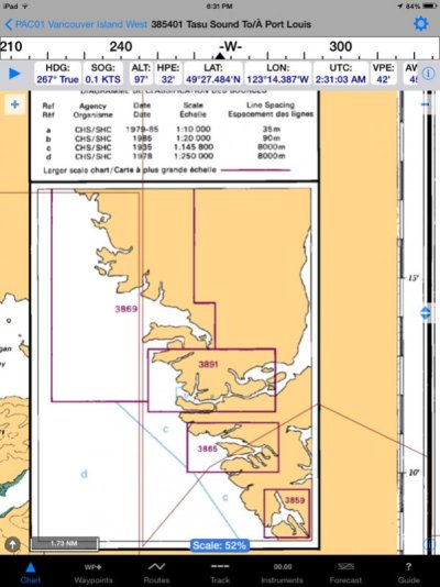
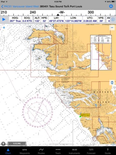
Here are some screen captures of the "current" CHS chart 3854 Tasu Sound to Port Louis off the west coast of Haida Gwaii. The first screen capture shows the transect lines for the soundings done by lead-line in 1935 prior to Hydroacoustics technology. The second screen capture shows the lack of soundings near the Moresby Island shore. The third screen capture shows the source classification for the chart. The CHS representatives indicated these soundings are very questionable for the early years and may be out by 500 metre in spatial positioning (latitude, longitude). image-2705884887.jpg image-1303528595.jpg image-3788129076.jpg Jim, Sent from my iPad using Trawler
 
Last edited:
Not sure what effect the new tech will have where every depth sounder out there on boats/ships could be a high def depthsounder recorder ...many coastal areas should have free, updated info available in a steady stream if governments want it and set up for it.

It would be a hard bargain for the government to charge for e-charts when a huge amount of relevant data is being produced by the end consumer.
 
Once, while sea kayaking, we made a run around a point of land on Hecate Strait to reach a beach before a squall hit. According to the chart it was supposed to be a cobble beach, but turned out to be covered in rocks the size of Fiats. Made for an interesting surf landing...I was ready to rip the head off the first chartographer I could get my hands on!!
 
Last edited:
It would be a hard bargain for the government to charge for e-charts when a huge amount of relevant data is being produced by the end consumer.

There are some efforts going on to create open sourced nautical charts - check out:
http://www.openseamap.org/

Today, satellite imagery of the coastline and normal open street maps have better accuracy than nautical chart coastline edges. Overlay buoy locations and soundings potentially generated from each other's tracks and we all can produce pretty good recreational charts. There are even some satellites now that can read depth information. If the data from those ever becomes public, we can have incredibly great charts without a government involved (except for the satellite!).

I have a feeling that in the future, we'll find it odd that we once paid for nautical charts much like it's rare to pay for street maps today. I threw out my Rand McNally map books about 8 years ago.
 
Hi JDCAVE,

Thanks for opening this discussion. Very timely and prescient. Although berthed in Everett, WA, I am a frequent visitor to Canadian waters, and thus a frequent user of CHS charting products. I, too, am somewhat aghast at the cost of CHS digital charting products. And, despite the current US Government position of not charging for NOAA charting products in US waters, I would not be surprised in the slightest at yet another "fee" in lieu of taxes tacked on NOAA charting products in the future. And that's all I'll say about that!

As far as accuracy of the bathymetry is concerned, I am suspect of "user data" finding its way into digital charting products. Not only is the accuracy suspect, but the volume of data available to make statistically accurate bathymetry in most areas, at least on the west coast, is low. I'm afraid I vote for needling both NOAA and CHS to fulfill their obligations to the taxpayers (both Canadian and American), and produce accurate charting products for everybody, everywhere in navigable waters. And if it thereby generates "user fees", well that's beyond my pay grade.

Thanks again for the topic. And thanks to CHS for making voyaging in foreign waters less difficult, albeit not always incident-free! Ya gotta love BC!

Regards,

Pete
 
Well, study after study shows that a community of interested members will create better crowdsourced data than any other technique. Harvard's recent research into using crowdsourcing for medical research showed how multiple people coming into the problem with different experience levels actually produce better results because the "professionals" will often overlook something that an interested person wouldn't. That has a direct tie into boating and is part of the reason NOAA is licensing our data today - they found it to be better than the Coast Guard data they had been using for many years previously.

Not only that but I don't think governments see the creation of nautical charts for recreational use as their front burner role. Chart creation is driven by commercial channel and military needs. That's why ENC data from NOAA is very lacking in the non-commercial areas while every port and major harbor is well produced as S-57/ENC data. I'm not sure I'd want to see governments getting into commercial businesses as a money generation goal either any more than they should be producing street maps for sale.
 
Last fall I got a quote in Canada for Trident with the US charts costing ZERO and the West coast Canada charts costing $299.

Last week I got a quote In the US for Coastal Explorer with the US charts costing ZERO and the West coast Canada charts costing $199.

One of the givens is most things cost more in Canada, just the way it is and always will be. I've worked and lived on both sides of the border for a very long time and fall back on "it is only money."
 
The CHS reps brought up the discussion of LIDAR to obtain depth contour information. They indicated it was very costly and weather condition have to be ideal. The near-shore area can be problematic because of kelp and shore vegetation. NOAA summarizes LIDAR as follows....

"A LIDAR instrument principally consists of a laser, a scanner, and a specialized GPS receiver. Airplanes and helicopters are the most commonly used platforms for acquiring LIDAR data over broad areas. Two types of LIDAR are topographic and bathymetric. Topographic LIDAR typically uses a near-infrared laser to map the land, while bathymetric lidar uses water-penetrating green light to also measure seafloor and riverbed elevations."

There are certainly possibilities and opportunities for "crowd sourcing" of information. However having been engaged in the science of Hydroacoustic technology for counting salmon etc. nothing is as trivial as it might seem at first. Calibration of instruments, water density, transducer angle, boundary effects, cross-talk all influence accuracy. It certainty helped to have a research scientist on staff with a PhD in physical oceanography to insure rigour and keep our expectations realistic. All vessels engaged in such activity would have to have their instrumentation examined for accuracy and compliance to some minimal standard. I'm not saying it can't be done, only that some sort of oversight and standardization is required.


Jim, Sent from my iPad using Trawler
 
Last edited:

Latest posts

Back
Top Bottom