What's below the surface?

The friendliest place on the web for anyone who enjoys boating.
If you have answers, please help by responding to the unanswered posts.

FlyWright

Guru
Site Team
Joined
Apr 15, 2008
Messages
13,731
Location
California Delta
Vessel Name
FlyWright
Vessel Make
1977 Marshall Californian 34 LRC
Unless one dives underwater, most of us spend our days enjoying life at the water's surface with occasional inadvertent encounters with the bottom. Yesterday, I had the opportunity to explore what lies below the surface due to our near record drought conditions in northern CA.

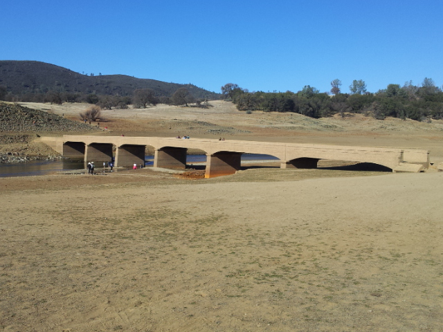
Folsom Lake normally sits at 466 ft MSL and is now sitting at below 359 ft MSL - more than 100 ft below full. This has exposed huge areas of the lake bed that have remained under water for nearly all the time since its construction in 1955.

We traveled several miles up the South Fork of the American River to access the old, normally submerged Salmon Falls Bridge. This area is normally a fairly wide channel of the lake, but has dwindled to little more than a babbling creek. I could have walked across sections and not gotten wet above my waist.

This is Salmon Falls Bridge which normally sits under 30 or more feet of water. I have boated under this bridge in my runabout in prior low-water years, but this is the first time I've been able to walk over it with dry feet. I noted a couple grooves that appeared to be propeller strikes into the concrete and stone surface.

img_207291_0_268e9179c73529d1a6987331d56af126.jpg


This shot gives a bit of an idea of just how low the water level is.

img_207291_1_a5065ad98fe601a2e100ad48b5cda4f0.jpg


It's hard to get a feel for the depth here, but this stone wall is an old reinforcement for the Old Salmon Falls Rd which normally sits under 20+ ft of water.

img_207291_2_97d15fd98159031ee1fc27d7c5999b34.jpg


Next week we plan to explore exposed portions in the main body of the lake. Here's a link with pics of the ruins of Mormon Island that sit there exposed to be explored.
 
Thanks for posting... Interesting. Will it ever return?
 
Thanks for posting... Interesting. Will it ever return?

I have confidence it will. One or two wet years should do it if we're lucky.

Al: Were there any fish?

I bet there are just as many fish in the lake now as there were months ago, but they're living in closer quarters than before. Should make it easier to find them. The problem is there are no boat launches available since the lake is at 17% of capacity.
 
I have confidence it will. One or two wet years should do it if we're lucky.

Actually, the lake could come back this rain season. The lake only is capable of holding about one third of the watershed which feeds it. So a wet Spring should bring the volume up quickly. Wet Spring??? We shall see...and hope. Folsom Lake was built as a flood control reservoir. Water supply for commercial, residential and hydroelectric use was a minor afterthought.
 
Last edited:
Thank you for posting.

For some odd reason, stuff like this turns my crank.
 
Makes me wince. Call me crazy, but I like my water running unimpeded from mountain top to ocean.
 
Austin Tx is worse I think. Lake Travis is less than 38% of "normal" these days and has been that way for a few years.

For Lake Travis: In 2011, inflows were the lowest in history and only about 10 percent of the annual average; In 2013, inflows were the second lowest in history at about 18 percent of the annual average; and In 2012, inflows were the sixth lowest in history at about 32 percent of the annual average.

Central TX has been in a terrible drought for 7 years...
 
Last edited:
Makes me wince. Call me crazy, but I like my water running unimpeded from mountain top to ocean.

That would work out just fine if you don't need to drink, irrigate, wash, cook with it, flush, provide recreation on it or provide flood control. Most people I know require and desire those 'luxuries'.
 
That would work out just fine if you don't need to drink, irrigate, wash, cook with it, flush, provide recreation on it or provide flood control. Most people I know require and desire those 'luxuries'.

Those aren't 'luxuries' here on the north coast of BC, as there is ample water for fish, fowl, animal, and humans combined...something I am more than grateful for every single day!
 
Makes me wince. Call me crazy, but I like my water running unimpeded from mountain top to ocean.

Murray

Is not the very existence of Kitimat and all the jobs etc it provides a result of the dams built over 50 years ago to provide the hydro power for refining Al?
 
Murray

Is not the very existence of Kitimat and all the jobs etc it provides a result of the dams built over 50 years ago to provide the hydro power for refining Al?

That would be Kemano, which is about 60 miles(?) and several mountain ranges away from Kitimat. It provides electricity for the aluminum smelter. All our water needs in town are easily met by the Kitimat River.

Not everybody here thinks the cumulative impacts from the aluminum smelter, massive clear cut logging, and the now closed pulp mill which pretty much wiped out the Kitimat Rivers oolichan and salmon runs is such a great thing...luckily, when given a chance, Nature tries to bounce back.
 
Not everybody here thinks the cumulative impacts from the aluminum smelter, massive clear cut logging, and the now closed pulp mill which pretty much wiped out the Kitimat Rivers oolichan and salmon runs is such a great thing...luckily, when given a chance, Nature tries to bounce back.

But, without the Al smelter there would be no Kitimat. No marina, no private boats and no place for me dock when cruising!.
 
But, without the Al smelter there would be no Kitimat. No marina, no private boats and no place for me dock when cruising!.

Oh, there would still be a Kitimat, or more likely it would be a much bigger Haisla community of Kitamaat which used to be on the lower Kitimat River before they got forced onto their current reserve. That was done in the good 'ol days, when the Haisla knew nothing was going on until the barges of equipment showed up to start construction.

I would have loved to have seen this place before industry had its way with it. Have you ever been into the Gilttoyees, just down the channel from Kitimat? It must have been like that, only much, much bigger.
 
It amazes me how far some people hope to go in 'managing' water...read about the North American Water and Power Alliance and be afraid...

"NAWAPA begins with construction of a series of dams in Alaska and the Canadian Yukon, trapping the water of the various rivers running through this largely undeveloped wilderness area. The drainage area to be tapped is approximately 1.3 million square miles, with a mean annual precipitation of 40 inches.

A large portion of the water thus collected would then be channeled into a man-modified reservoir 500 miles long, 10 miles wide, and 300 feet deep, constructed out of the southern end of the natural gorge known as the Rocky Mountain Trench in the Canadian province of British Columbia. This would be accomplished through a series of connecting tunnels, canals, lakes, dams, and, because the trench itself exists at an elevation of 3,000 feet, even lifts. The network of projects provides plentiful opportunities for hydroelectric power development.

To the east, a thirty-foot deep canal would be cut from the Trench to Lake Superior, to maintain a constant water level and clean out pollution in the entire Great Lakes system from Duluth to Buffalo. Not only would this provide more water for hydroelectric power and agricultural irrigation of the Great Plains region of Canada and the U.S.A., the canal could ultimately be made navigable for lake- and ocean-going vessels from the Great Lakes into the heart of Alberta, and eventually, extended westward into Howe Sound, British Columbia. The dream of a Northwest Passage would at last become a fact, from the Gulf of St. Lawrence to Vancouver.

South from the Trench reservoir, water would be lifted through a giant dump lift to the Sawtooth Reservoir in southwestern Montana, from which point it would flow by gravity through the western part of the system, passing through a tunnel in the Sawtooth Mountain eighty feet in diameter and fifty miles in length, to the western and southern U.S. states.

South of the Rocky Mountain Trench, in central Idaho and southeastern Washington, a series of hydroelectric plants would develop the Clearwater and Clearwater North Fork Rivers and the lower reaches of the Salmon and Snake Rivers. Flow of the Columbia River would be supplemented as needed from other rivers as well as regulated at its direct connection to the Rocky Mountain Trench Reservoir to prevent flooding. NAWAPA aqueducts and reservoirs would dot the slopes of the Rocky Mountains, providing water to the Staked Plains and lower Rio Grande River basin and serving New Mexico, Texas, Colorado, Kansas, Nebraska, Oklahoma and Mexico via existing rivers.

Flows from the Rocky Mountain Trench and Clearwater subsystem would also supply Idaho, Oregon, Utah, Nevada, California, and Arizona in the United States; and Baja California, Chihuahua, and Sonora in Mexico. A diversion aqueduct at Trout Creek, Utah would send high-quality, low- mineral water to southern California and Baja California. Here it would arrest soil damage caused by high-mineral Colorado River irrigation water."


http://larouchepac.com/node/15310
 
It amazes me how far some people hope to go in 'managing' water...

As they say, "Whiskey's for drinking. Water's for fighting over."
 
Forget it Jake, it's just Chinatown.
 
Last edited:
California's water "management" helps account for about 40% of produce consumed in the United States. We take water management very seriously, but don't always get it right:)
 
Just imagine someone trying to build a dam (in the USA) and flood a town today for whatever reason. There would be meetings and lawsuits well into the next century. There are people now trying to get dams removed from streams and rivers. Dams that provide flood control, irrigation, recreation and electric power.

We could do without the dams but we would have to get rid of most of the people. Go back to the population of the 1700s.
 
In the east, states are condemning earthen dams left and right and removing them when necessary for decades worth of ignoring maintenance.

In cases where they had to be drained immediately for public safety reasons....entire lakeside communities with expensive homes now circle a giant mud pit that teams of all sorts of undesirable wildlife and effects.
 
My son lives in Rocklin and took his two daughters to the lake. They found an outboard motor in the mud without a cover. My son figured the owner tried to start the thing , got fed up and tossed it over the side. As long as I see green golf courses there is no drought.
 
The Tennessee Valley Authority flooded towns and farms when taming the Tennessee River and tributaries. Communities and farms were flooded. Concrete silos can be seen on some of the lakes. Many here have benefited from the navigation aspects afforded by the projects. Others by the electric power and flood control. These are complex questions about if projects like this should be done. However, as long as we have people, engineers will figure a way to solve or create problems.

Tennessee Valley Authority - Wikipedia, the free encyclopedia
 
Let's stay out of the political arena in our discussion or else we'll end up having to move this to Off Topic. I'll follow up with photos of the town of Mormon Island when I get them.
 
I heard on the news this morning that a search for a private plane in the lake was called off. The plane was involved in a mid-air collision with another private plane in 1965. Four people were onboard the plane that hit the water (the other plane suffered minor damage and was able to land at a local airport). All four of the people lost their lives and one body was recovered shortly after the accident. The hope was to find the wreckage of the plane in the shallow water and recover the remains of the other three passengers.
 
I saw something on that, too. There was a specially equipped sonar search boat that volunteered to assist in the narrowed field of water with the low water level. 1965...49 years ago. A lot of mud could build up in those years. That could be a tough find.
 
Fly-I had just read an article in the paper last week abut your drought down there. Apparently most of the man-made lakes in CA are will below capacity. According to the article, there is a serious potential for water supply problems in SoCal this summer.

We are having a fairly dry winter up here. The snowpack in the Cascades (our version of a reservoir) is down quite a bit. Several of the lower elevation ski places have been unable to open until the last 2 weeks or so.
 

Latest posts

Back
Top Bottom