Navigation Software

The friendliest place on the web for anyone who enjoys boating.
If you have answers, please help by responding to the unanswered posts.
I have used Polar. I "won" it off Active Captain. Still not completely clear on how I won it, but hey... whatever ;-)

I have about zero experience with OpenCPN... I like the Polar software. I like it a lot. But I never used it as a primary nav tool. It was a backup only and was only for lower helm use. I had to run it on my laptop. I don't normally run the genset underway and there was always the possibility of battery depletion. I have now added a chartplotter station to the lower helm, so it's unlikely I will need it again.

The thing I liked about it was that it would run NOAA charts and vector (or raster... I get them confused). I liked the option. I liked the Active Captain interface too.

The things I disliked were that it wasn't very easy to use. I little bit of trial and error to get View and Com to talk to each other... More like, that you even needed to have them talk was the confusing part. Also, installing Active Capt. update was a bit of a pain too. Most of these things should happen automatically or at least have a prompt that reminds you to do it.

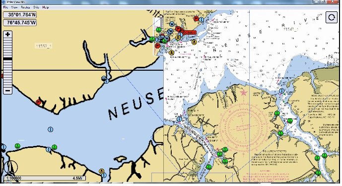
There were also some other things like the screen shot below. I'm really not zoomed out very far and I feel stitched at two incompatible zoom levels.

Like I said... I liked it and may use it again, but I think the GUI could use an overhaul (unless it's designed for touchscreen) and just some other minor tweaks would be good.
 

Attachments

  • Untitled.jpg
    Untitled.jpg
    123.3 KB · Views: 144
Spinning circle certainly exists, but the time you mention (5 seconds) is quite unusual. Generally, PolarView has one of (if not the) fastest rendering engines, especially with raster charts.

What's the total system RAM?
Are your charts installed locally on the hard drive?
Also, it is worth selecting only one chart type, either vector or raster (but not both) from View->Chart Types menu.

On my laptop and desktop if I drag the chart or zoom out I get a spinning circle like the shot below. Sometimes it is fast and sometimes it can take maybe 5 seconds. My guess it has to do with available memory but that's just a guess. OpenCPN doesn't have that. I do use two different chart types with the older one in OpenCPN and the newer (raster?) in PolarView so maybe it is just a graphics generation thing.
 
" I don't normally run the genset underway and there was always the possibility of battery depletion."

This caught my eye. No alternators either? Or are you talking about the laptop's battery? No inverter then?

Anyway I am also in the camp of using the PC or Mac as a planning and backup device, but I know plenty of people who happily cruise the seas with computer nav only. I usually prefer purpose-built stuff for whatever reason. My Macs have proven to be pretty fragile devices and seem to want to stop and pout about something at the wrong moment. We are on the second set of these (i-Mac and MacBook Pro) on the boat as of last year as the first generations failed after about 4 years of use. Don't ask me why, but we kind of got forced to re-up based on when and where each went Tango Uniform.

To me the biggest advantages of PC based navigation these days is the ability to download completely updated charts at any time for free for US waters, and at fairly nominal cost elsewhere. I noted when I bought a new Navionics card for my Furunos the other day, that Navionics is now allowing you free web based updates to their cards for a year's time. The next big advantage is being to do planning and dreaming when away from the boat. Further down the list is cost.
 
I don't disagree, George. I love the up-to-date chart possibilities. But the time I used my laptop was before my inverter install. Still, I'd rather have a proper chartplotter at the helm rather than something that relies on Windows or OSX to run. Too many points of failure.
 
Worth remembering that your chartplotter is probably running Linux (or Android, or VXWorks). I.e. - it's a computer, except manufacturer made sure it can only run one program, and duck-taped all the extra buttons so user can't press them :)

That said, being waterproof and self-contained is certainly an advantage.
 
Brak - I only have one set of charts for each program - under chart info on PolarView it says type S57 (vector or raster?). The maps are loaded on the hard drive and my desktop has 4 gig and my laptop 1. For my main GPS I use a Furuno V2 but I have the laptop on the dash as a backup and so I can zoom in to look at details of a destination and the Active Captain info. One thing I really like is that I can have very up-to-date charts and it saves me from having to buy a chip update nearly as often. In fact I will get my first update to the Furuno this summer before our maiden voyage to Florida. I find PolarView to be a very solid product and - once I figured it out - the PolarCOM link works fine too.

Tom.B - You should try loading the "other" charts - raster or vector (I have the same problem remembering which is which). I find they quilt together nicely and IMO contain better detail.

Dave
 
Just a laptop got me from Ft Lauderdale to Jersey, back to Jekyll Island and now back to Myrtle Beach.....I change and build routes all the time underway with OpenCPN....this summer I'll try and integrate everything.

I'm sure there are programs with more bels and whistles...but for free OpenCPN is everything most people need.

The only reason I'll probably have a dedicated chartplotter in the future is to add RADAR.
 
.......
The only reason I'll probably have a dedicated chartplotter in the future is to add RADAR.

I expect its only a matter of time until someone writes a plugin(s) to implement radar display on O. Aside from that very real and constant improvement, what I most like about OpenCPN is the complete lack of nonsense. I can right click a route or waypoint underway and get instant access to whatever I am likely to want to do. I don't get the phone number at the marina or walking directions to the nearest pub or a picture of the skyline - but I don't want or need that crap either.

As far as the supposedly unreliable computer to operate O goes, I've got two identical laptops onboard right now, both with O and all the charts loaded. I've got 2 pucks that connect to those computers plus a Garmin eTrex with a USB connection. If SWMBO is onboard her computer is a third backup. If all that fails then I'll take my chances with my eyeballs, a paper chart and a depthfinder.

A couple of years ago I took an introductory celestial nav course. At the start of the class we went "round the horn" stating why we were taking the class. I think I said "for a lark" but one of the kids said he was going to cross oceans and he wanted to carry a sextant as a backup. The instructor said "are you nuts? - if you want a backup take another GPS - if that isn't enough - take another one." That's the way I feel about this "reliable purpose built electronics" refrain. I think my level of redundancy is considerably ahead of anyone who depends on a single chartplotter no matter how well waterproofed it may be. YMMV
 
... I don't get the phone number at the marina or walking directions to the nearest pub or a picture of the skyline - but I don't want or need that crap either.
Good thing one man's crap is another man's feast. Coming out of Long Island Sound bound for Block Island last summer we ran into unpredicted weather and rapidly building open water seas. A quick look at the charting software showed what could be a protected anchorage to our southwest. The anchor icon displayed from the Active Captain information download showed someone had been there before. A couple more clicks and I knew we could fit our draft and hold bottom. There wasn't a phone # for pizza, but it did let us make a decision and get out of the weather PDQ. For some it's information overload... for a guy who wrote computer software for 30 years it's an information junkie's fix.

Dave
 
I have been a user of Nobeltec VNS for the last 7 odd years and still like it.
Previously used Tsunami and TMQ C Plot.
Tsunami was by far my favourite but support faltered. C Plot is favoured by probably 75% of the trawler (fishing) operators in Australia and covers world wide charts in all formats (You just have to buy them)

Some of the other programs around are really USA centric so a bit of research has to be carried out if you are going to use this plotter software outside the USA where charts are also free from my understanding.

I have heard the rumblings re Nobletec Odyssey so am so far reluctant to upgrade but will always stick with a computer based plotter system due to their more versitile usage , number of computers being able to be used for planing and back up ect.

Benn
 
Some of the other programs around are really USA centric so a bit of research has to be carried out if you are going to use this plotter software outside the USA where charts are also free from my understanding.

That's a big consideration for some people, and one of the reasons I've gone with Coastal Explorer - charts are available for everywhere. Everyone has good US charts - that's easy - but as you start to venture off into the far reaches of the planet, having a selection and being able to pick best of breed is important.
 
I think Active Captain is unbelievable info for the cruiser...I use it several times a day while cruising...even though it's not part of OpenCPN yet....I just get it off my wifi while underway or at the marina the night before.

Before I even leave on a leg..I have a pretty good idea of weather and possible "stops" or"duck-ins" before I even leave....having it available 100 percent of the time is great but really one step further than needed.

I really like it too, but for me the off-line feature is critical since I'm out of wifi range all the time until anchored or in a marina, and even then wifi isn't always available. And the web site doesn't work on an iPad so it's not accessible via 3G, or at least not with the stuff I use. There are iPAD apps that include AC, but then it's yet another nav app, and I need fewer, not more.
 
As far as the supposedly unreliable computer to operate O goes, I've got two identical laptops onboard right now, both with O and all the charts loaded. I've got 2 pucks that connect to those computers plus a Garmin eTrex with a USB connection. If SWMBO is onboard her computer is a third backup. If all that fails then I'll take my chances with my eyeballs, a paper chart and a depthfinder.

If they are so reliable then why do you have so many of them?

Actually I don't know if the plotters are more reliable than the computers, in the long haul but so far they are winning the race by two lengths. I trust none of them.

Full disclosure: Two Furuno plotters (networked, but can operate independently) plus an RD 30 repeater, two GPS receivers, one which also feeds a serial out to hook to laptop via USB. A laptop and a desktop, and a third GPS via a Bluetooth puck. Also an etrex around here somewhere. Three compasses and a pair of bearing binocs with compass. Plotting instruments, paper charts and a partridge in a pear tree.

You never know!
 
If they are so reliable then why do you have so many of them?

I didn't realize that two counted as "so many" - one is my personal laptop - its with me all the time anyway. One is a dedicated nav computer. Why do you have so many systems if they are as reliable as you claim?
 
I didn't realize that two counted as "so many" - one is my personal laptop - its with me all the time anyway. One is a dedicated nav computer. Why do you have so many systems if they are as reliable as you claim?

Re-read my post, I didn't claim reliability, I said I don't trust any of them. I like the purpose built stuff because it is much easier to use, plus includes radar and fish finder view, and, as noted, hasn't broken or crashed or frozen. They came with the boat. The computers came as a result of the boat being our primary residence. I like planning and daydreaming using the computer when away from the boat. A friend gave me the etrex. The paper charts and the partridge are standard whenever I go boating.

Got it now?
 
Actually I don't know if the plotters are more reliable than the computers, in the long haul but so far they are winning the race by two lengths.

Re-read my post, I didn't claim reliability .....

????

If they are so reliable then why do you have so many of them?

You asked. I answered.

I don't have any trouble using O. In fact its ease of use is one of its greatest features. As a result of this thread though I am willing to admit that Active Captain integration would be a big plus. Active Captain has much more information for this area than it did even a year ago. I hadn't looked at it for a while & was pleasantly surprised by the information I found there tonight.
 
If you have a Mac, I highly recommend MacENC; almost every kind of functionality you could imagine, free updates, and the very best customer support I think I have ever seen. Not in the budget zone at $180, but compared to Coastal Explorer and Nobletec, definitely a bargain. When you wander out of the US, you can buy Navionics Gold charts that cover huge areas through X_Traverse, as well as ENCs form various foreign countries; the program is used by a lot of overseas users, truly global.

will this software run the free noaa charts as well? and interface to ais radar depthsounder etc?
 
Try SeaClear. II. It's free and seems to do the job. Freeware is the wave of the future, I'm guessing.
 
Even with multiple GPS receivers you still have a single point failure. The military doesn't rely solely on GPS because they know how easily it can be jammed or disabled. If all GPS stopped working how would you navigate?
 
Even with multiple GPS receivers you still have a single point failure. The military doesn't rely solely on GPS because they know how easily it can be jammed or disabled. If all GPS stopped working how would you navigate?

I'd do what the old Polynesians did: dangle the boys in the water and follow the warm currents.
 
Even with multiple GPS receivers you still have a single point failure. The military doesn't rely solely on GPS because they know how easily it can be jammed or disabled. If all GPS stopped working how would you navigate?


Most of us could still pilot just fine for where we boat...a depthsonder is pretty much all you need as backup for the one in a trillion chance that someone is jamming GPS ner you.
 
Actually, GPS being affected in one way or another has happened a few times around here, likely due to the very large military presence; sometimes it is in the LNM as a pre-announcement, other times it happens mysteriously in very small areas ( a one mile area that included my marina once).

Before I ever experienced that, we have long been in the habit of having the appropriate paper chart book open at the helm with all plotting equipment immediately at hand. On longer trips, we pencil in time, position, heading and speed every hour or so on the chart. Kind of makes a nice "visual logbook" for future reference up to the point you have to start erasing entries due to congestion. Plus I like the "really big picture" afforded by the paper chart.
 
Most of us could still pilot just fine for where we boat...a depthsonder is pretty much all you need as backup for the one in a trillion chance that someone is jamming GPS ner you.

I guess there's also a measureable chance that an EMP will take out my entire electronics suite but there's some risks I'm prepared to live with.
 
I guess there's also a measureable chance that an EMP will take out my entire electronics suite but there's some risks I'm prepared to live with.

[FONT=Arial, Helvetica, sans-serif]who cares, if it wasn't for sailors without fear of the water we would all still be in Europe waiting for the world to end but we're not. So the point being, who needs all this technology anyway? We discovered the world without it
[/FONT]
 
I have Coastal Explorer since 2009 and like it. Is there any reason to upgrade ($99) to CE 2011. My version seems to work pretty well, it gets me there and back.
 
There are iPAD apps that include AC, but then it's yet another nav app, and I need fewer, not more.

We have no use for computer-based navigation (laptop, etc), preferring dedicated units. But there is a very nice, simple charting app for the iPad which we have and use in the same way we use paper charts--- to get the "big picture" or to scan or peruse the waters around us as we go.

This app is Navimatics and it includes the Active Captain overlay and database (if you are a member of AC and download the database to the app). Navimatics is not a navigation app per se--- you cannot created, store, and follow routes. (You can enter a simple, one-leg, straight-line route from where you are to another point and the app will display steering directions to follow it, but that's it as far as actual navigation is concerned.)

But as a tool for moving rapidly around the charts, zooming in and out and panning with just a few finger swipes to go from "big picture" to close-in detail, it's great.

And it's the perfect tool for using Active Captain. The AC database is downloaded into the iPad so you do not have to be on-line to use it. You do need to be on-line in to download the latest updates to the AC database. But once you've done that there is no need to be on-line to use database.

If you have a 3G/4G iPad, it has a built-in, stand-alone GPS receiver so it can track your position on the Navimatics charts in real time with no connectivity required at all. It will even leave a track of your boat's progress.

Since it's not a full-up plotter-type app its cost is pretty reasonable, about $25 IIRC. You have to order the version with the region of the US you want. In our case it's the "US&CA West" version which includes the west coast from the Mexican border all the way up through BC and all of Alaska.

At its widest display setting it will show from the lower end of Puget Sound to the top end of Vancouver Island. From that screen display it's just a matter of a couple of finger pinches to go in tight on our marina with just our and a couple of neighboring docks on the screen.

All in all a great tool for planning ahead or looking at the waters around you as you travel with no need to keep zooming and panning on the boat's actual plotter displays. And with the Active Captain markers on the charts, you can find out about marinas, harbors, anchorages, etc. right on the spot.
 
Last edited:

Latest posts

Back
Top Bottom