Those who have and those who will...

The friendliest place on the web for anyone who enjoys boating.
If you have answers, please help by responding to the unanswered posts.

Chris Foster

Senior Member
Joined
Oct 12, 2007
Messages
280
Location
USA
Vessel Name
Thea
Vessel Make
46 Grand Banks Classic
and those who will again...

(Long post - my apologies.* I had thought that I should suggest a new Trawler Forum section called "Confessional" until I realized that I was probably the only one doing sufficiently stupid things to post there).

I thought that I was pretty much immune to going aground, since I had already managed to do so about 15 years ago.* After all, the old saying says that there are two types of boaters, those who have and those that will, and absolutely NOTHING about those who will do it TWICE!!

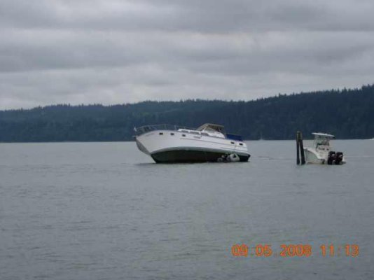
So there I was last Sunday, approaching the south end of Swinomish channel.* For the non-PNW types, the channel is dredged through an extensive shallow that dries at very low water.* We were approaching from the north, so we needed to keep to the west in deeper water until passing the #1 bouy, indicating the start of the dredged channel.* Then we could turn left (east) into the channel.

Well, it turns out that from a couple of miles out, the #1 and #3 bouys look a whole lot alike.* I ***thought*** that I had scanned the horizon carefully.* Within about a 10 second period, the following took place:

- what the heck is that bouy over there that I didn't notice before?

- why does the boat sound kinda funny?

- uhhh... hard to starboard, quick...

- sudden stop

At this point, I fortunately stopped being stupid and (I think) did things pretty much right.* The first thing that I did was absolutely nothing ... namely, not going into reverse.* Thought*about it for a moment.**The tide was rising, so we should float off in a bit.* Shut down the engines (don't want to plug the cooling water intakes).* Don't do anything stupid.* It's sand/mud bottom, so there's no danger of having damaged the boat (yet, at least).

So after pondering my foolish predicament for a moment, I did notice that both wind and tide were coming from the west, which would tend to push us towards shallower water if we floated off.* Launched the skiff and had someone lower the anchor to me carefully.

Started to row off to drop and anchor as a kedge at 90 degrees to the bow (towards the west - into the wind and current and deeper water).* After about 10 feet, discovered the obvious:* I can't pull chain across the bottom.* Pull the bit of chain that did come out back into the dink, and then had my buddy load about the next 100 feet of chain along with me.

Row - row - row my boat, and the chain happily slowly pulled out as I did.* Got to the end of the chain, and stuck an oar down to find about five feet of water below the dink.* Dropped the anchor in, retreived the oar that I dropped, and rowed back to the boat.

So now we started putting a strain on the anchor chain.* This was to do 3 things:* keep from drifing into shallower water if we did start to float off, pull us into deeper water if possible, and pull the bow around so that we would be heading towards deeper water immediately once we started to float (without having to turn).

Over the next 20-30 minutes, things worked out pretty much as planned.* The anchor set just with the pull of the winch.* After about 10 minutes, you could feel the boat rock just a bit with passing wakes.* Ever so slowly, we could pull in a few inches of chain, and just as slowly, the bow started to come around a few degrees at a time.* In about 20 minutes, the tide had come up to the point that she was balancing on the keel, and you could feel her starting to rock again.* A few minutes later, the bow had come around 90 degrees.* And finally - glory be and saints be praised - she floated off and we could pull in the anchor chain.

Fired up the engines and she moved under her own power.* Retreived the anchor, stowed the dink, and we went on with our day.

In the midst of all of this, I did notice that the GPS plotter in the main cabin showed quite clearly that we were not where we should be.** Of course, we were up on the flybridge, where it did us no good.

So am I immune for another 15 years???
 
There are relatively inexpensive plotters with built-in antennas (Standard Horizon makes some of them) that can be mounted on a flying bridge consol and removed from their mount when not being used. While we no longer operate the boat from the flying bridge, when we did we have a large Magellan handheld plotter that uses C-Map NT cards, same as one of the full-size plotters down below. Its mount is secured to the flying bridge consol but we took the plotter inside when we were not using it.* It runs off batteries or external power so it was simple matter to run a DC feed up through the flying bridge consol to the mount.

Sounds like you did everything right. Friends of our several years ago went aground in the same channel. The husband was an avid reader of all the Patrick O'Brien books (Master & Commander, etc.) and recalled the kedging technique. They did the same thing--- took the anchor out in the dinghy and then managed to haul the boat off backwards before it got totally stranded.

I have seen photos of a Grand Banks 42 woodie that went aground in the Swinomish Channel years ago as the tide was going out. The boat went over onto its chine, and when the tide came back in the water came up over the low gunwale and entered the cabin and flooded the boat. A couple from the marina in Cornet Bay salvaged and raised it and restored it. I don't know if they had to buy it from an insurance company or not.

But a lot of people, including me at the time, don't realize that when many configurations of boat go over at an angle like that the amount of water needed to refloat it and turn it upright will be higher than the low side of the deck and cabin, and the result will be a boat that floods before it floats.

-- Edited by Marin at 22:25, 2008-10-02
 
Excellent recovery, Chris.

Something I try to do before leaving the dock is to set my cheapo depth sounder alarm at 5'. This sometimes causes me to panic when a false positive or small area of shoaling causes the alarm to go off. It also would be of no use in a situation where the bottom rises quickly. But for most of where we cruise around here, it's nice to have the sounder keeping an eye out.
 
Chris, being based in Anacortes and having to make the run south often for boat shows, etc., we know the Swinomish Channel well.* It can be very tricky in the area where you went aground.* Even with a chart plotter, I have noticed that I am physically not in the center of that channel even though the Nobeltec plotter shows I am.* The only real way to navigate that channel safely is to ust the range markers to the west and give the entrance buoys a wide berth, especially at low tide.*

It sounds like you did all the right things, though and everthing turned out fine.*

As as side note, a very close friend of mine was headed east and making the turn north up by Eagles' Nest (a couple of miles to the east of your grounding) a few years ago and he cut too close to the bluff there and ended up aground on a falling tide.* They were on a Hudson Force 50 sail boat.* The boat ended up on its side.* They set an anchor with the dinghy and slept part of the night on the port bulkhead until the boat righted itself at high tide.
 
Vinny wrote:

I as you didn't realize that a GB would not come off her side on her own,* maybe a lot of rail meat would have helped or a couple of anchors set off the high side rail that could be pulled in as the water came up.
I don't know that there is much that can be done when an aground*boat like a GB goes over onto the chine when the tide goes out.* In the case of a GB36, that's 26,000 to 28,000 pounds of boat and trying to haul that up faster than the water's rising would be beyond the capabilities of any people or equipment on the boat I think.* Putting props under the low side to support the boat as the water goes out from under it might work, but who carries timbers or stands around with them, plus all that weight would likely simply drive the props into the mud.

So I dunno if there's any sort of a workable solution except not going aground in the first place.* There is at least one place in the San Juan Islands--- Fisherman's Bay on Lopez--- that has a very winding and shallow entrance channel.* Boats go aground there*all the time.* We went there for the first time this last July and all the advice we were given by people with way more experience than us was to always or leave*the bay on a rising tide.* Then if you do manage to go aground, like Chris the rising water will float you off.
 
One thing to think about if you do wind up on your side is through hull fittings, particularly for galley and head sinks. These can wind up below the waterline as a boat raises, even if the gunnels still have freeboard.
 
Lessee...

This is NOT a charts vs plotter vs compass discussion restart... but... I did look at the little Garmin plotter down in the main cabin and saw clear as day the little dots going straight towards shallow water.* Had I had it (or something similar) on the FB, I'd have been fine.* I'm probably going to pick one up next year like Marin suggests - I find the speed-over-ground readout to be very useful when trying to find nearshore eddies when fighting a current through a channel.

Didn't see the depth sounder on the FB because I wasn't driving at the time, and it's angled towards the helmsman.* However, it's a little suspect, as I did take a look at it during that 10 seconds just before we hit, and I think it was indicating thirty some feet.* Don't know if that was multiple reflections or not.

I have heard of the stuck-on-the-side problem before - in Chapmans, I think.* Since both of my groundings have been on low/rising tides, I haven't had to deal with it - but if I were in Sunday's situation with a downgoing tide, I'd have been on the phone to Vessel Assist in about two seconds.* Even if I didin't have the BloatUS coverage.* I believe that they have some big air bags that they can rig to keep the boat from going farther over than necessary and to float it off straightaway.* I know there are lots of places they don't cover, but if I thought there was any chance they could get there before the tide change, I'd be on the horn to them.
 
Here is what greeted us as we left the Slough on our way south last month. He had apparently come from the south and did not see/obey the last bouy or wait to line up the range markers before turning. From the rear it appeared that a good portion of the aft cabin was flooded when we passed.

There but for the grace of God (or whatever diety you may or may not believe in)

Ken

I guess I should add for those not familiar with the area that along the dredged waterway is a long rock retaining wall to keep the silt from filling the channel. The wall is submerged until about half tide or so. This boat sits on that wall.

-- Edited by 2bucks at 18:48, 2008-10-04
 

Attachments

  • photo1.jpg
    photo1.jpg
    18.3 KB · Views: 71
I guess if you cruise the NW, then you will have a story about the Swinomish Channel. I remember as a kid seeing a 40' Cruise-a-Home sitting on top of the rock retaining wall. That sight gave me respect for the channel entrances. Recently, we were headed North one late afternoon and were planning to stop over in Laconner for the night. As we rounded Strawberry Point on Whidbey Island, a 36' Maxxum came up behind and blasted by on the Starboard side, leaving a sizeable wake to deal with. As Captain and guests all naively waved to us, we scrambled to alter course and catch any flying objects (the wife was still stowing our gear for the week long trip). As we got close to the South entrance of the channel, we saw the Maxxum cruising out to the North, in the shallow area. I briefly hoped to see them stuck, then thought better of it since I'd have to get involved and this would get me to the dock and the Crown Royal later than I'd like. Well, this fellow heads toward us at a slower speed and waves us down. He tells me he is lost and do I know anyplace the can tie up for the night? I couldn't believe it. Nightfall was less than 30 minutes away, this guy is out here without a clue! I tell him Laconner is probably his best bet, just go right up the channel. He decides to follow us after his jaunt into the shallows. We get in and tie up and I go ver to talk to this guy. This is his first boat and second time out. First time out engine over heated because of plugged sea strainer, then deystroyed a prop heading back in on one engine. He said his repair bill was over $16,000. Full complement of Raymarine gear, but doesn't know how anything works. I strongly suggest that he get a captian that train him how to use the equipment and sign up for the Power Squadron courses, but he's got it all handled. Then to top it off, he complains that when he was following us in, they were getting tired of the "diesel smell". Well, that was enough, good riddance to this fellow. I had some ice and Crown waiting.
 
Minor correction fon my original story:* it was the 5 bouy that I was inadvertentently aiming for - there is no 3 bouy.* But in my feeble defense:* it sems to me that there would be a good argument for the 1 & 2 bouys to be cans instead of nuns.* You can't read a "1" versus a "5" a couple of miles even with good binocs, but you sure can tell a nun from a can.* Probably would have kept me out of the mush.*
hmm.gif


What (to me) is pretty appalling is how poorly marked the jetty is on the 18427 chart.* While you can make the argument that you have absolutely no business entering*the channel inside of the 2 bouy, so the presence or absence of the jetty is irrelevant, a lot of*boats end up on top of it.* But you really need*your reading glasses plus a magifiying glass to see that there is a jetty there at all.

In*happier news, I did see that the Corps will be dredging the southern half of the channel this fall.*
 
By this fall you mean 09? And especially the area around Shelter Bay? Yippee!
 
Being we have a 6 ft draft, I am very cautious about the depth, channel, and buoys.* I tend to follow and/or call sail boats.* I figure if they can make it I can make it.* One of the best features of Chart view/Navtech is the tide and current animated feature.* So before any boat trip will map out the route, and run the tide current feature to see when is the best time to go through a narrow/shallow channel.* As mentioned before I try to go through before high slack tide so if we do go a ground the chances are we can float off.

*
My best advise is to follow sails boats at a distance.* ****

*

*

*
 
Always amazes me how different y'alls boating is than ours.* I go aground once or twice a year in some form or another.* When you operate a vessel with a 3 1/2 foot draft in an area that averages about 4' depths, it's gonna happen.*

On the other hand, our tide range is about 2', so you don't generally have the laying over on the chine and filling up with water deal.* Only exception here is the total knuckleheads who run up onto a very shallow shoal at high water on a big spring tide.* In that case you may see a 4' plus range.

I once read an old passagemaker article about some PNW boaters who charterd a trawler in Pine Island Sound/Charrlotte Harbor (a GB, I think) and were FREAKED for a whole week that there was only two feet or so under the keel.* I laughed cause they seemed like wimps to me, but I guess if*I look at their backgrounds as illustrated here I can understand it.

Of course they still bitched about the heat and bugs.
 
On the run that's depicted in the first*attached photo (in the PNW), the depth was ocasionally 1,000.' Most of the time it was between 500' and 800' in this relatively narrow channel. It can be over 100 feet deep a boat-length from shore in many places up here*which can make anchoring a bit of a challenge.....

The tidal range in this area can run to 15 feet or more, and farther up the BC and SE Alaska coast you go the tidal range is even higher. That's not so much the issue, it's the currents that are created as the tide changes that makes life interesting. In some passes the currents run 14 knots at max flood or ebb.* The second photo (lifted off the web) is of one of the tidal currents in a pass in BC.* This happens to be Skookumchuck Rapids in BC. (Skookum is pidgin Indian for "big," "strong," and chuck is a term for*water, generally assumed to be salt water.)* This is one of the more notorious rapids in the area but there are others that are almost as wild.* Hard to believe looking at this that at slack water (which lasts about 15 minutes) this is dead flat calm.

Less than ten feet under our keel makes us real nervous unless it's in a place we've been before. While we pay very close attention to the paper and electronic charts when we're navigating, there is always the fear of that "uncharted" rock reaching up to get you. Or a deadhead half buried in the mud. So my wife and I regard ten feet of water as pretty thin. With the tidal range, we generally seek to anchor in about 30 feet of water if we can, although there are places where we're forced to anchor much deeper.* But you have to be careful because 30 feet of water and a sensible scope could put enough chain out to put you into the shoreline behind you if the current or wind swings you that way.

-- Edited by Marin at 18:59, 2008-10-07
 

Attachments

  • 05-toward vondonop 1.jpg
    05-toward vondonop 1.jpg
    42.1 KB · Views: 75
  • skookumchuck.jpg
    skookumchuck.jpg
    84.2 KB · Views: 95

Latest posts

Back
Top Bottom