In the thread about instrument panel layouts someone mentioned that these days a magnetic compass is almost irrelevant and not to give it much consideration when designing a panel or helm console layout.* So I thought it might be interesting for people to post their own ideas regarding the value of a magnetic compass.
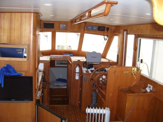
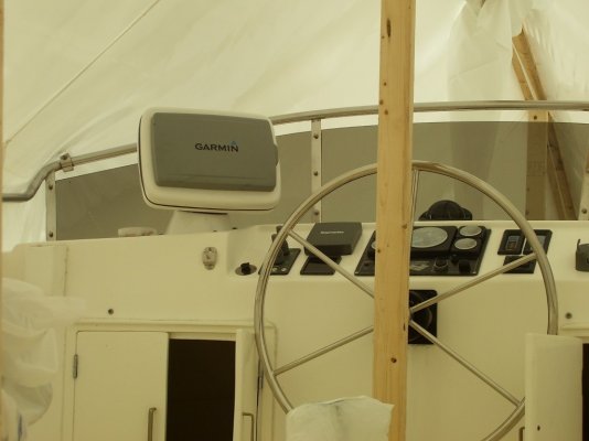
In our waters, where the current seems to change every hundred yards, we find ourselves using the magnetic compass almost constantly.* We have two large GPS plotters at the helm station, one of them a plotter only and the other a Furuno NavNet (radar and plotter).* Both plotters have what in aviation are called "noodles" or the dotted lines that extend forward of the boat's position indicator and tell you were you will be in a predetermined time that you can adjust.* We have the noodles on both our plotters set for ten minutes, as I recall.* (You can also set them to show a specific distance.)
We removed the autopilot from our boat when we bought it and so steer by hand.* We have both found it is a lot easier to hold a heading using the magnetic compass than by chasing the plotters around.* We use the plotters or their steering displays to confirm that the heading we are holding with the compass is still accurate and hasn't been changed by the current.* But trying to hold a heading using the plotters alone requires an almost constant reference to the plotters because of the frequent and sometimes rather radical current changes we encounter on virtually every leg of a trip.* The heading and bearing readouts on the plotters are digital so you have to read the numbers to see what's changed, and the noodles, while "analog" and so don't require any "reading" to decipher, don't make small heading changes readily apparent immediately (this depends on the scale the plotter is set to, of course).
Our magnetic compass, on the other hand, is easy to read at a glance and it makes heading changes, even very tiny ones, immediately and obviously apparent.* Plus the compass is mounted in a place the helmsman is looking anyway, so there is no need to look to the side, look down, or look up at a plotter display all the time.
Eric mentioned not liking an overhead position for a plotter, and I don't disagree with him.* However, the plotter function of the Furuno (like most if not all modern plotters) has a very user-friendly steering display.* It's somewhat in the form of a graphic compass but includes heading and bearing information as well as a simple graphic showing where the boat is in relation to the course line and which way to steer to get back to the course line.* We usually split the Furuno screen to have the radar display in the top half and the steering display in the lower half.* (The older, green-screen Echotec plotter we leave in chart display all the time.)* So it's just a matter of a quick glance up--- it doesn't even require any head movement--- to confirm that the compass heading we are holding is the correct one for the current we're in.* But the compass is our primary steering tool as far as holding a specific heading is concerned.
Based on this experience, were we designing a panel or helm station layout for a new boat, we would make sure the magnetic compass was a good one, large enough to be very easily readable, and mounted in a position where it was in or nearly in the helmsman's normal line of sight when looking forward.
That's for these waters.* Were we boating in something like the ICW, which from the photos I've seen is essentially a ditch, a magnetic compass would perhaps have little value with regards to steering the boat.*
I don't know how useful a magnetic compass would be for open water/ocean cruisers today.* While I've done a lot of ocean fishing in Hawaii, we were never out of sight of land even when we were twenty or thirty miles out and so simply used the island on the horizon as our reference point.* Of course the boat had a compass, but this was in the days before GPS and we didn't have a Loran so the compass was it with regards to navigation equipment.* But I don't recall us every actually referring to it.
-- Edited by Marin on Monday 20th of December 2010 01:22:24 PM