You are using an out of date browser. It may not display this or other websites correctly.
You should upgrade or use an alternative browser.
You should upgrade or use an alternative browser.
Time for a new chartplotter
- Thread starter Tom.B
- Start date
The friendliest place on the web for anyone who enjoys boating.
If you have answers, please help by responding to the unanswered posts.
If you have answers, please help by responding to the unanswered posts.
Phil Fill
Guru
- Joined
- Oct 11, 2007
- Messages
- 2,919
- Location
- US
- Vessel Name
- Eagle
- Vessel Make
- Roughwater 58 pilot house
I would get Radar before a chart plotter as a Rader can be also be used as a chart plotter if you can see the shore line as well as knowing what is out there.  The best bang for the bucks is to bundle the radar and charts together. Might want to look at the new broad band radar that give better detail but with short range. I need another radar for back up which will probable be broad band with electronic charts.
If you go bundled let us know what you get.
The best bang for the bucks is to bundle the radar and charts together. Might want to look at the new broad band radar that give better detail but with short range. I need another radar for back up which will probable be broad band with electronic charts. If you go bundled let us know what you get.
Last edited:
dwhatty
Moderator Emeritus
- Joined
- Sep 25, 2008
- Messages
- 2,846
- Location
- USA
- Vessel Name
- "Emily Anne"
- Vessel Make
- 2001 Island Gypsy 32 Europa (Hull #146)
Another vote for Garmin. We have both the 4208 & the 4210. We find them easy & intuitive to use with great radar/chart overlay. The advice we got when we bought was to stay away from the touchscreen not only because of smudges but also because 1. setting a way point by touch was generally not as accurate as doing it with a pointer and 2. if you are rolling around our there it can be problematic to get your finger to go to the spot you wish to place the waypoint.
Scary
Guru
I can't speak to the Garmin products
But I agree that the smear screens are not practical in any boat that moves around. The track balls on the Furuno aren't that smooth either, at least mine wasn't. I think it would be nice to have a wireless mouse option for boats with a pilot house. Back to the pc/laptop with software and a gps puck. I have lost gps input on several occasions, the first time was just off Victoria BC at night. We were approaching Victoria and as slow as my boat moves I hadn't noticed that my position was not updating until I was wondering what the Brotchi ledge light was and why had they changed the LOCATION OF THE BREAK WATER. Fortunately Coastal Explorer has a warning in the upper right corner of the screen but I missed it the first time. I've lost signal several times since so I've learned to watch for it. I don't think it's Coastal Explorer , it may be my puck or just maybe the USB connection to the lap top but it's less than perfectly reliable.Another vote for Garmin. We have both the 4208 & the 4210. We find them easy & intuitive to use with great radar/chart overlay. The advice we got when we bought was to stay away from the touchscreen not only because of smudges but also because 1. setting a way point by touch was generally not as accurate as doing it with a pointer and 2. if you are rolling around our there it can be problematic to get your finger to go to the spot you wish to place the waypoint.
GonzoF1; said:So, that being said, what are your thoughts on 5-7" units?
Thanks,
Tom-
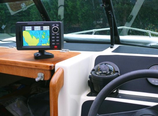
We bought a 5" Standard Horizon unit for our 17' Arima and are very happy with it for that application. But in my opinion a 5" screen is too small for a primary navigation display unless it's going to be very close to you, as it is on the Arima where its mounting puts it about 15 inches from my face. In my opinion a 7" display is the smallest I would recommend for "normal" mounting and even then I think it's marginal. For mounting on a console out in front of the helmsman by three or more feet I would not consider anything less than 10 inches.
I'm not a fan of Garmin other than for automotive GPS units. But that's a primarily subjective opinion. I am, however, very impressed with the Standard Horizon, particularly its display--- it's the brightest display I've seen. I haven't seen Carey's 12" SH plotter yet but if its display is anything like ours it must really be something. Even in direct sun with no top up on the Arima the SH display is very bright and readable. But at only 5," as bright as it is I would not want to use it for navigation if it was mounted farther away from me.
Last edited:
But I agree that the smear screens are not practical in any boat that moves around. The track balls on the Furuno aren't that smooth either, at least mine wasn't.
That is one advantage of the 7" Furuno NavNet--- no track ball. I would still recommnd the 10" over the 7" but the absence of a trackball on the 7" is nice.
Daddyo
Guru
We've been using small Standard Horizon units for ten years with no problems. I like the c-map charts. As to the small screen (5") it works fine if your not splitting it or radar overlaying. Bigger would be fun but not a necessity.
psneeld
Guru
I have a question about the Standard Horizon. The plotter is a few years old now. Will the preloaded charts be up-to-date?
no...even a brand new chip isn't up to date...but neither are paper charts.
people that poo-poo laptop nav don't sometimes realize that flexiiliy of chart uploading/patching.
now...certainly the big chunks don't change much so a couple year old chart isn't that big of a deal either. Very few people keep up with all the LMNs...
- Joined
- Jun 25, 2008
- Messages
- 10,104
- Location
- Australia
- Vessel Name
- Now boatless - sold 6/2018
- Vessel Make
- Had a Clipper (CHB) 34
Roger that. I too only have a 5" screen, and that's on a combo, and I often have the sonar and the GPS half & half, and yet I can still tell exactly where I am, and my eyesight is only average and I wear glasses. Sure, bigger would be nicer in some ways, especially if I wanted to overlay radar, which I would if I had it, but don't, but for everything else in my view my navigation with 5" is just as accurate as it would be with 7, 8 or 10", but the cost significantly less. 'course, if money is not object....go for it...but you are not underprivileged using 5", as the unit is just as accurate and reliable - just smaller.We've been using small Standard Horizon units for ten years with no problems. I like the c-map charts. As to the small screen (5") it works fine if your not splitting it or radar overlaying. Bigger would be fun but not a necessity.
I have a question about the Standard Horizon. The plotter is a few years old now. Will the preloaded charts be up-to-date?
You can update the units when they come out with an updated data package. I suspect it's something you have to have the electronics dealer do. The C-Map Max card that you can buy goes in the slot in the unit, so updating that is a matter of updating the card, which again is something the dealer can do since he burns them for you.
However, as psneeld said, the thing will be outdated the moment you buy it. I realize that for places like the ICW where channels and bars are shifting around on an ongoing basis, updates may be more critical. Out here, not so much. We still use the chartplotter we installed when we bought the boat, an Echotec 310MP green-screen that uses C-Map NT+ cards. C-Map has long since moved beyond the type of card we have-- you can't even get them made or updated today--- but so far as we've experienced, nothing around here has changed. The basic marina data in it has changed, of course, but we have never used that feature on this plotter.
Our Furuno NavNet VX2 is only a few years old but in terms of navigation and charts and the old Echotec match all the time. But the NavNet's marina and facilities data is out of date, too, now.
Same with our year-old Standard Horizon.
This is one reason the iPad with Navimatics charts and Active Captain overlaid on them will be so handy, because both of these apps are continuously updated. Great reference tool, but not something you'd want to actually navigate the boat with.
Last edited:
MauleOne
Veteran Member
- Joined
- Jan 22, 2011
- Messages
- 58
Chart Plotter
I am in the market also for a new system.
I currently have the original Furuno Nav Net on a 7" screen. It is an intergrated unit with chart plotter, radar and fish finder combined.
It is now 10 years old and part of it still works ok. The radar never has been right and I think it is dying now.
Unfortunately when Furuno came out with their newer Nav Net systems they made them so they were not compatable with the original system. In other words I can not upgrade unless I want to buy the whole thing.
I have been wondering about the new broad band radar ( should make it its own thread). It sounds like what I need to navigate through the fog. Who cares about something a mile away, I worry about what I am going to run into 3 ft away.
I need a integrated system to replace an integrated system. Will continue to watch the developments before I can decide.
Good luck.
Broad band has its advantages and disadvantages. If you search the archives of this forum you should find one or more discussions about it with comparisons to "standard" radar.
I don't know anything about the original NavNet system. We have NavNet VX2 and think it is outstanding, particularly the radar which makes the 1980s-vintage Raytheon unit it replaced seem like something out of the Middle Ages. The NavNet plotter is excellent, too, although I've mentioned that some of its features are not as intuitive as I've seen or experienced in other makes like Standard Horizon. But because we were replacing a radar and we already had an excellent (for its day) large-sreen plotter, the radar function of the NavNet was our primary interest. We have not added the depth feature to the unit.
Raymarine is the other "big" integrated navigation system manufacturer. I've not used their equipment so I can't comment on it from personal experience. I can say that I have heard or read more complaints about Raymarine equipment than any of the other major brands, more to do with reliability and service than its actual function.
Were we in the market today for a stand-alone plotter, I would seriously consider one of the larger Standard Horizon units along the lines of what Carey of this forum recently added to his custom lobsterboat. I have been VERY impressed with our year-old 5" unit. It's user interface and method of handling waypoints and routes is different than what we're used to on our Echotec and Furuno (both of which are different from each other), so it's taken some time to get used to using it and we still have not had that much experience with it. I think I prefer Furuno's method of waypoint and route creation and storage to the Standard Horizon's but that's a totally subjective opinion.
I have not seen or used Furuno's NavNet 3D. John Baker has, I believe, as his wife works for a dealer or distributor of this system. So if he sees this he may have some useful input for you on that newer Furuno integrated system.
Regardless, if your requirements include a new radar, unless the attributes of broadband will serve you better (they don't for us) I maintain that you can't do better than Furuno. Up here we do care about what is more than a mile away because of all our shipping, ferries, and fishing boats. But we are also concerned about crab pot buoys and such up close. We have found that the Furuno radar is great for both longer ranges and close-up, although the close-up capabilities of broadband seem to be better.
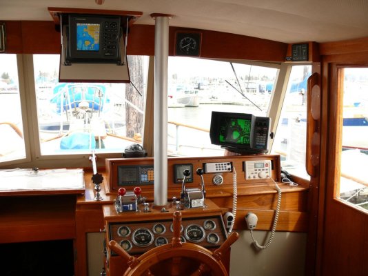
The first photo is of the lower helm in the GB (the radio pictured has since been replaced), the second is of our new Standard Horizon plotter mounted on our Arima (it can also be mounted on the GB). The brightness of the SH screen is impressive--- in the photo which was taken with the top down on the Arima this is not even the display's brightest setting.
I don't know anything about the original NavNet system. We have NavNet VX2 and think it is outstanding, particularly the radar which makes the 1980s-vintage Raytheon unit it replaced seem like something out of the Middle Ages. The NavNet plotter is excellent, too, although I've mentioned that some of its features are not as intuitive as I've seen or experienced in other makes like Standard Horizon. But because we were replacing a radar and we already had an excellent (for its day) large-sreen plotter, the radar function of the NavNet was our primary interest. We have not added the depth feature to the unit.
Raymarine is the other "big" integrated navigation system manufacturer. I've not used their equipment so I can't comment on it from personal experience. I can say that I have heard or read more complaints about Raymarine equipment than any of the other major brands, more to do with reliability and service than its actual function.
Were we in the market today for a stand-alone plotter, I would seriously consider one of the larger Standard Horizon units along the lines of what Carey of this forum recently added to his custom lobsterboat. I have been VERY impressed with our year-old 5" unit. It's user interface and method of handling waypoints and routes is different than what we're used to on our Echotec and Furuno (both of which are different from each other), so it's taken some time to get used to using it and we still have not had that much experience with it. I think I prefer Furuno's method of waypoint and route creation and storage to the Standard Horizon's but that's a totally subjective opinion.
I have not seen or used Furuno's NavNet 3D. John Baker has, I believe, as his wife works for a dealer or distributor of this system. So if he sees this he may have some useful input for you on that newer Furuno integrated system.
Regardless, if your requirements include a new radar, unless the attributes of broadband will serve you better (they don't for us) I maintain that you can't do better than Furuno. Up here we do care about what is more than a mile away because of all our shipping, ferries, and fishing boats. But we are also concerned about crab pot buoys and such up close. We have found that the Furuno radar is great for both longer ranges and close-up, although the close-up capabilities of broadband seem to be better.
The first photo is of the lower helm in the GB (the radio pictured has since been replaced), the second is of our new Standard Horizon plotter mounted on our Arima (it can also be mounted on the GB). The brightness of the SH screen is impressive--- in the photo which was taken with the top down on the Arima this is not even the display's brightest setting.
Attachments
Last edited:
It is now 10 years old and part of it still works ok. The radar never has been right and I think it is dying now.
I don't know where you are located but Furuno has an excellent factory service center in Washington State. You might want to contact them (unless there is one nearer to you) to find out if they can diagnose and repair your current system. Might be more cost effective than buying something new.
MauleOne
Veteran Member
- Joined
- Jan 22, 2011
- Messages
- 58
Radar
Marin
Of course your are right, getting it fixed would be a lot cheapre than replacing it but not as much fun.
I need to give Furuno a call and give them a chance to straighten this Nav Net out.
The price difference will buy some fuel.
Marin
Of course your are right, getting it fixed would be a lot cheapre than replacing it but not as much fun.
I need to give Furuno a call and give them a chance to straighten this Nav Net out.
The price difference will buy some fuel.
Marin
Of course your are right, getting it fixed would be a lot cheapre than replacing it but not as much fun.
No argument there!
")
Fighterpilot
Senior Member
- Joined
- Apr 17, 2011
- Messages
- 380
Marin, is Active Captain an app for the Ipad?
Marin, is Active Captain an app for the Ipad?
Yes and no. (How's that for clarity?)
We've only just started using it so I am by no means an expert on it. Active Captain is a web-based application. It has its own website https://activecaptain.com/. You create an account (free) on the website using a computer. And if you use Active Captain on that computer, it contains the charts for your area, or in areas where it doesn't have the charts, like the more northern BC waters, it has maps and satellite imagery.
The data points, which are red, blue, green and yellow squares, are overlaid onto the charts or maps or satellite views. You can click on them and read the information, you can add comments (reviews) to them, and you can create new ones for places you've been and have info that you think other boaters could benefit from. You can download the Active Captain updates (for free) periodically to get the latest information that users have entered.
That's all on a real computer.
Active Captain is available on the iPad, too, but as an element of a another party's charting app. In our case, we downloaded the Navimatics chart app that covers the US and Canadian west coasts as well as all of Alaska, and Hawaii. The cost of this app is about $25.
Navimatics has the ability to overlay the Active Captain data points onto the charts contained in the Navimatics data base. But.... you need to have an Active Captain account in order to download the data to the Navimatics app on the iPad. And so far as I can determine, the only way you can set up an Active Captain account is using a real computer.
Once you've downloaded the current Active Captain data base into the iPad chart app (it takes the better part of an hour to do this) you can turn on the Active Captain layer in the app and the data point squares will be overlaid on the charts. Selecting a data point will expand it and give you all the normal Active Captain info.
You can also add user comments to an existing Active Captain data point using the iPad. What you can't do, it seems, is create a new data point from the iPad. You have to use a computer for that.
And you can download the latest Active Captain updates using the iPad. Once you have the current data base loaded, downloading the updates doesn't take very long at all.
According to the Active Captain website they are being added to other iPad chart apps all the time. Navimatics is the one that seems to get the most recognition right now, but there are apparently others. I don't know if the big (and expensive) Navionics app for the iPad has the capability to overlay Active Captain data or not.
And now you know pretty much everything I know about the subject.
I may have gotten some of this wrong because we're very new to the Active Captain operation. I had kind of ignored it in the past because I thought it was primarily an east coast-Great Loop sort of thing, which is apparently how it started. But after getting the Navimatics chart app I figured, what the hell, Active Captain is free so let's see what it has to offer. And it has a ton of great stuff for our part of the world. So very, very worthwhile in our opinions.
Last edited:
ben2go
Guru
I am going to try out some of the PC based stuff.I only use it as back up to a chart plotter.Laptop mounts are available for severe duty and impact absorption.May help those that pound through rough seas and want to used a laptop.I won't have a fly bridge and my cabin is enclosed and dry,so moister shouldn't be an issue.Humidity,maybe.
OP
OP
Tom.B
Moderator Emeritus
- Joined
- Jul 30, 2009
- Messages
- 5,839
- Location
- USA
- Vessel Name
- Skinny Dippin'
- Vessel Make
- Navigator 4200 Classic
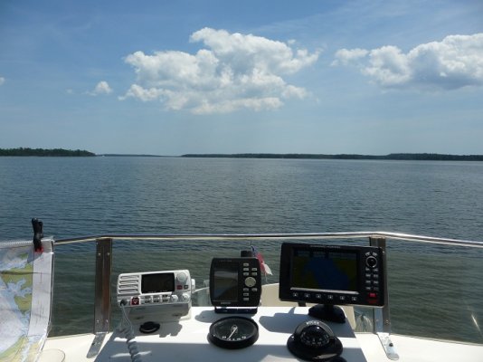
FOLLOW UP - We bought, and I have installed, the Standard Horizon CP390i and we are both pretty happy with it. Definitely a very bright screen. Charts seem correct everywhere we went this weekend. Size is perfect for the space we have for it and it's pretty easy to use. The WAAS antenna we have for our last plotter plugs right in, so we'll use the internal antenna on the flybridge, but I will rig a secondary station at the lower helm.
Thanks for all the advice y'all.
Thanks for all the advice y'all.
Attachments
Last edited:
ARoss
Guru
- Joined
- Nov 17, 2007
- Messages
- 637
- Vessel Name
- My Yuki
- Vessel Make
- 1973 Marine Trader 34
FOLLOW UP - We bought, and I have installed, the Standard Horizon CP390i and we are both pretty happy with it. Definitely a very bright screen. Charts seem correct everywhere we went this weekend. Size is perfect for the space we have for it and it's pretty easy to use. The WAAS antenna we have for our last plotter plugs right in, so we'll use the internal antenna on the flybridge, but I will rig a secondary station at the lower helm.
Thanks for all the advice y'all.
Save that photo. It'll remind you that the Neuse isn't ALWAYS trying to jolt out your teeth.
Similar threads
- Replies
- 0
- Views
- 199
- Replies
- 27
- Views
- 2K
- Replies
- 22
- Views
- 2K
- Replies
- 9
- Views
- 636