You are using an out of date browser. It may not display this or other websites correctly.
You should upgrade or use an alternative browser.
You should upgrade or use an alternative browser.
Standard Horizon Plotters
- Thread starter Carey
- Start date
The friendliest place on the web for anyone who enjoys boating.
If you have answers, please help by responding to the unanswered posts.
If you have answers, please help by responding to the unanswered posts.
bshanafelt
Senior Member
- Joined
- Oct 6, 2007
- Messages
- 427
- Vessel Name
- Isobel K
- Vessel Make
- 37' Custom Pilothouse
OP
OP
Carey
Guru
- Joined
- Oct 5, 2007
- Messages
- 1,101
- Location
- USA
- Vessel Name
- Happy Destiny
- Vessel Make
- Custom Lobster Yacht
*Thanks Bshanbshanafelt wrote:
I have had the cp1000c which is a 10" since 2004. It has performed flawlessly. Uses C-Map chips.
It also redraws very fast.
Additionally, there are 2 inputs for cameras.* I use one for a rearview unit.
How about user friendliness?
Tom.B
Moderator Emeritus
- Joined
- Jul 30, 2009
- Messages
- 5,839
- Location
- USA
- Vessel Name
- Skinny Dippin'
- Vessel Make
- Navigator 4200 Classic
I am taking a serious look at the CPN1010i. It *finally* ships March 1st and is a great deal for a 10" plotter with a street price of less than $2K. Will it hold up to the new Raymarine line? I can't answer that, but one thing I believe is that for the "cruising" we are doing on Skinny Dippin' (just yutzing up and down the ICW and the Neuse River), a high dollar plotter is not really necessary.
psneeld
Guru
*Where*is a*high dollar plotter more necessary?GonzoF1 wrote:
I am taking a serious look at the CPN1010i. It *finally* ships March 1st and is a great deal for a 10" plotter with a street price of less than $2K. Will it hold up to the new Raymarine line? I can't answer that, but one thing I believe is that for the "cruising" we are doing on Skinny Dippin' (just yutzing up and down the ICW and the Neuse River), a high dollar plotter is not really necessary.
We have had a 12inch Standard Horizon unit for the past 3 years. It has performed without problems with C-Map charts. Great value. Made in Italy - not China!! And has extended warranty for 3 years. Can't beat the value. Should be able to get one for about $1K on line.
Chris
Chris
Tom.B
Moderator Emeritus
- Joined
- Jul 30, 2009
- Messages
- 5,839
- Location
- USA
- Vessel Name
- Skinny Dippin'
- Vessel Make
- Navigator 4200 Classic
*Where*is a*high dollar plotter more necessary?psneeld wrote:GonzoF1 wrote:
I am taking a serious look at the CPN1010i. It *finally* ships March 1st and is a great deal for a 10" plotter with a street price of less than $2K. Will it hold up to the new Raymarine line? I can't answer that, but one thing I believe is that for the "cruising" we are doing on Skinny Dippin' (just yutzing up and down the ICW and the Neuse River), a high dollar plotter is not really necessary.
That's a good question. Maybe on a high-dollar boat?:-D
TBH, I would probably want one if I was going to be out-of-sight of land for a long time or in a boat like a center console that would beat the pure-T-sh*t out of everything onboard.
Moonstruck
Guru
- Joined
- Nov 27, 2008
- Messages
- 8,276
- Location
- USA
- Vessel Name
- Moonstruck
- Vessel Make
- Sabre 42 Hardtop Express
TBH, I would probably want one if I was going to be out-of-sight of land for a long time or in a boat like a center console that would beat the pure-T-sh*t out of everything onboard.GonzoF1 wrote:
*On my Blackfin I have an older model SH plotter with small screen. *Crusiing along at 22-24 knots in 3 foot seas it has never faltered. *Pretty easy to use, I just like the 10" screen on Moonstruck better.
Carey, doesn't Marin have a SH on his fishing boat?
-- Edited by Moonstruck on Monday 30th of January 2012 10:20:29 AM
OP
OP
Carey
Guru
- Joined
- Oct 5, 2007
- Messages
- 1,101
- Location
- USA
- Vessel Name
- Happy Destiny
- Vessel Make
- Custom Lobster Yacht
GonzoGonzoF1 wrote:
I am taking a serious look at the CPN1010i. It *finally* ships March 1st and is a great deal for a 10" plotter with a street price of less than $2K. Will it hold up to the new Raymarine line? I can't answer that, but one thing I believe is that for the "cruising" we are doing on Skinny Dippin' (just yutzing up and down the ICW and the Neuse River), a high dollar plotter is not really necessary.
I was very interested in the 1010i until I looked at the overall size of the unit and realized that even though it is a 10 inch diagonal screen, the height is less than 5 inches. I am now thinking 12", as I like the height to width ratio better.*
Thanks, Carey
OP
OP
Carey
Guru
- Joined
- Oct 5, 2007
- Messages
- 1,101
- Location
- USA
- Vessel Name
- Happy Destiny
- Vessel Make
- Custom Lobster Yacht
TBH, I would probably want one if I was going to be out-of-sight of land for a long time or in a boat like a center console that would beat the pure-T-sh*t out of everything onboard.Moonstruck wrote:GonzoF1 wrote:
*On my Blackfin I have an older model SH plotter with small screen. *Crusiing along at 22-24 knots in 3 foot seas it has never faltered. *Pretty easy to use, I just like the 10" screen on Moonstruck better.
Carey, doesn't Marin have a SH on his fishing boat?
-- Edited by Moonstruck on Monday 30th of January 2012 10:20:29 AM
Thanks Don. Yes, I believe that Marin's fishing boat does have a small SH. I have not seen it or discussed it with him however.
Thanks to all of you. I think you have helped me decide on either the CP 500, or CP 590. I will talk to our local dealer to find out the real difference between these two. They are both 12", and appear identical. I wouldn't be surprized if the 590 is just meant to appear like a new model.
Thanks again all*

Tom.B
Moderator Emeritus
- Joined
- Jul 30, 2009
- Messages
- 5,839
- Location
- USA
- Vessel Name
- Skinny Dippin'
- Vessel Make
- Navigator 4200 Classic
*That's actually appealing to me. I like the side-by-side info a screen like that can provide and I have a bit of a sightline vertical restriction in the location I want to mount it. ;-)Carey wrote:Gonzo
I was very interested in the 1010i until I looked at the overall size of the unit and realized that even though it is a 10 inch diagonal screen, the height is less than 5 inches. I am now thinking 12", as I like the height to width ratio better.*
Thanks, Carey
Ocean Breeze NL
Guru
- Joined
- Oct 29, 2011
- Messages
- 525
- Location
- Canada
- Vessel Name
- Ocean Breeze
- Vessel Make
- Ocean Alexander 85OA38
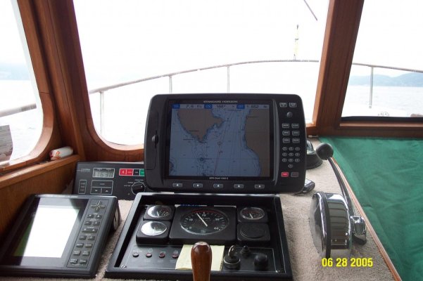
Looks good there Carey. Are you using the built-in Charting program or are you using another ( downloaded or plug-in )?
Elwin
Elwin
OP
OP
Carey
Guru
- Joined
- Oct 5, 2007
- Messages
- 1,101
- Location
- USA
- Vessel Name
- Happy Destiny
- Vessel Make
- Custom Lobster Yacht
ElwinLooks good there Carey. Are you using the built-in Charting program or are you using another ( downloaded or plug-in )?
Elwin
I got the standard C Maps plus C Max. I will get on the water next week and see how it performs. Also note the new bucket seats at the helm. We got a chance to check them out in 3'-4' seas, and it was really nice having the bolsters to help keep us in our seats. They are Corbeau seats purchased from "Autobahn". Not exactly Recarro or Stidd, but better than we had.
Nomad Willy
Guru
Pardon me for posting here as I have a Garmin but I do'nt like the horizontal format. I can't see why anyone would want a plotter screen wider than it is tall. ...except for the purpose of running more than one thing at the same time on one screen and that's probably the reason. But I'd like to find a plotter w a square screen (as I have no interest in running more than one function on the plotter). Does anybody make a plotter w a square screen ......say 12 X 12"?
psneeld wrote:
*Where*is a*high dollar plotter more necessary?
I'm going to say if one was to navigate in a very challenging area one may be able to take advantage of a high end plotter. Here in SE Alaska the better the plotter the better. But there is only so much information on the charts and no plotter will have more than what the charts have. A nice touch screen would probably enable me to search and surf for more anchorages faster so that may be of value to a skipper w a faster boat or more stuff to search. I spoze it all depends on how much the special features cost and if the're worth it.
Perhaps the best plotter is two plotters. One to navigate with and one to explore with and plan ahead. But then if one plans ahead one really would'nt need to do that Hmmmmmmmmm
Last edited:
Giggitoni
Guru
- Joined
- Jun 21, 2008
- Messages
- 2,092
- Location
- United States
- Vessel Name
- Mahalo Moi
- Vessel Make
- 1986 Grand Banks 42 Classic
Eric, it actually looks like a square display from here (of course, I'm about 900 miles away!). The little "data windows" that Carey has along the top make it look landscaped. Take those away and you'd have a square display, or pretty close.
Last edited:
Perhaps the best plotter is two plotters. One to navigate with and one to explore with and plan ahead.
That's why we got the Navimatics chart app for our iPad. We already have two full-size C-Map plotters on the boat. But what we didn't have was the ability to move fast all around the charts, zoom in, zoom out, see close detail, then zoom out for the "big picture," or pan over 5 or 50 miles to check things out. The iPad lets you do this with just finger swipes on the screen.
We have paper charts at the helm when we're underway but while these let you see the bigger picture to change the area being viewed you have to change the chart. The Navimatics app will follow your boat but you can zoom in and out at will or pan to a completely different area than where the boat is at the moment.
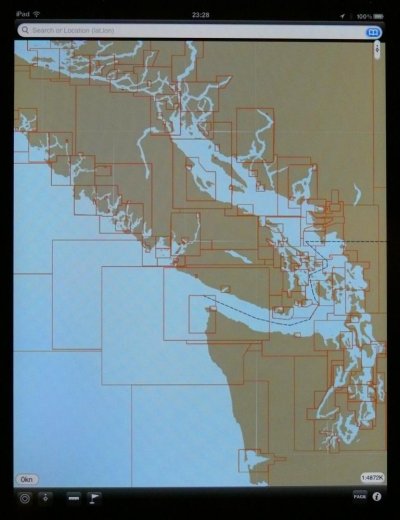
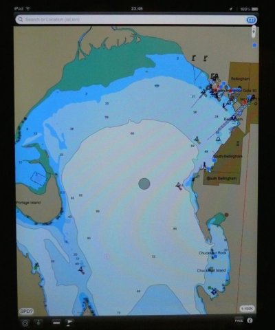
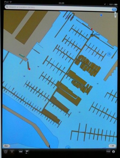
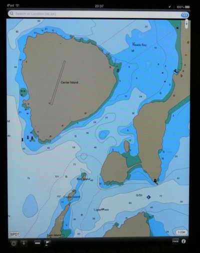
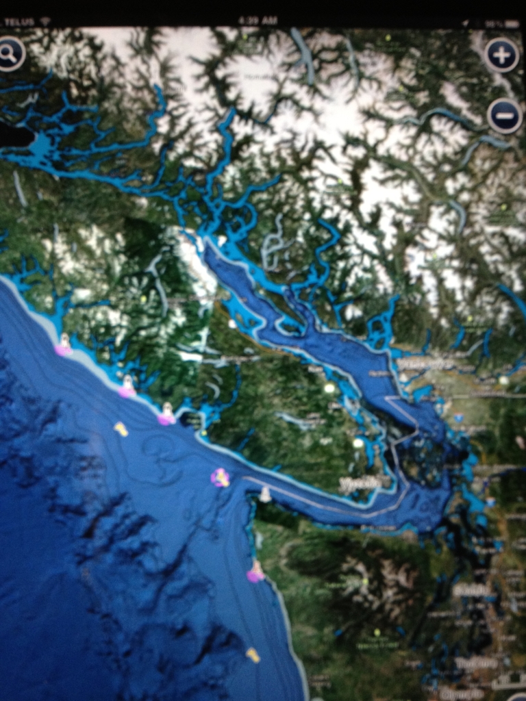
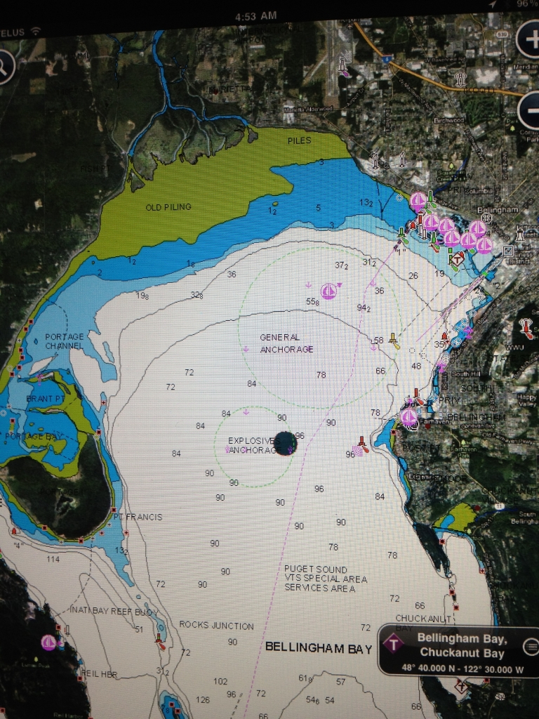
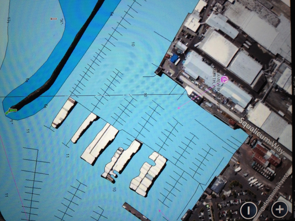
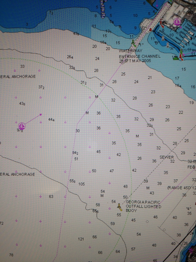
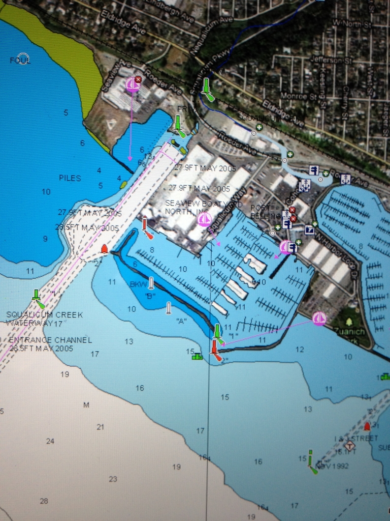
These are four shots I took of our iPad's screen just now. We have the Navimatics app for the US and Canadian west coasts plus all of Alaska and Hawaii. The first shot is zoomed as far out as the app goes on our part of the coast. The red lines outline the charts that make up this part of the display. The second shot is zoomed in to Bellingham Bay. The third shot is zoomed in as far as the app will go on our section of Squalicum Marina. The fourth shot is our island in the San Juans.
Moving between all these views was a matter of two or three finger swipes. And like almost all iPad apps, the display orients to how you're holding the iPad. So you can have a vertical display like this one or a horizontal display. The Navimatics charts are all vector charts so no matter how you orient them on the screen all the lettering, navaids, and other symbols stay right side up.
The little colored squares on some of the displays are Active Captain data points.
Attachments
Last edited:
Ocean Breeze NL
Guru
- Joined
- Oct 29, 2011
- Messages
- 525
- Location
- Canada
- Vessel Name
- Ocean Breeze
- Vessel Make
- Ocean Alexander 85OA38
Here are a couple of shots taken from my iPad using Navionics Charting. The camera shot doesn't do justice to the image shown on the iPad because of the reflection from the glass. The google overlay gives it a more of a real look then the other overlays and I like it the best. I believe Marin the charting programs are similar. Definitely advantages to having the charting on the iPad for off-line planning.
Good representation of the ocean floor in this first one
Elwin
Good representation of the ocean floor in this first one
Elwin
Last edited:
Similar threads
- Replies
- 8
- Views
- 948
- Replies
- 22
- Views
- 2K
- Replies
- 7
- Views
- 409
- Replies
- 15
- Views
- 2K
Latest posts
-

-

-
Best Android Tablet to Run Navionics App?
- Latest: Portage_Bay
-
-

-
-

-
-