Paper charts in jeopardy?

The friendliest place on the web for anyone who enjoys boating.
If you have answers, please help by responding to the unanswered posts.
Just saying the last I looked Canada law requires raster electronic charts to be backed up with paper not so for vector electronics. So maybe there is something wrong with raster. Also after the US Navy lost a ship using electronic charts I believe they now require paper on the bridge. I personally have seen the problem with scaling on electronic charts where important information can easily be missed which is obvious on paper. My take and what I do, navigate by electronics, confirm with paper.
 
Last edited:
I believe the Canada rule only works with vector charts (ELC) with IMO approved chartplotters so the vector charts are more informative.

You take a 15 year old Navionics chart in the typical old Furuno or similar Garmin plotter and the vector charts look like they were hand drawn by school children and about as informatine.

Cmap from the same vintage had greater detail, to a point, but many layers deep.
 
I am among those who use both paper and electronic at the same time. Essentially I navigate by means of the electronic charts but I keep a paper chart showing a much larger area open to continue to give me an idea of where I am. We rarely zoom out the electronic charts to give us the big picture, thus the paper chart is useful.

Paper charts in book form are cheap and for the way I use them they do not have to be updated.

Marty!

I see that you're a Mod �� Congratulations! Now get this thread back on track....

Edit: ...and Pete (Pau Hana) you too!
 
Last edited:
For shoreside detail, don't you have access to aerial/satelite photos ?? I thought Garmin had a "Birds Eye" view option that included that, but I'm not sure where I read that....
 
Charts seem mostly decades old in their readings. (Over thirty-years old in my area.) Cruise at your own risk. Watch your depth readings.
 
The first time I traveled from CT to FL I spent $500 on large format paper chart books. Now where did I put those?? What a waste of $$.
 
For shoreside detail, don't you have access to aerial/satelite photos ?? I thought Garmin had a "Birds Eye" view option that included that, but I'm not sure where I read that....


I have a whole stack of paper charts from back in the 80's. They work great for basic trip planning. I much prefer to do planning at a dining room table with a bunch of charts than at my computer.

Again, that is just me. I'm sure there are kinds of reasons that is a "bad idea".
 
Operation of vector charts if different than raster charts, but I think you will find all the info is there. For bridges, for example, you typically need to click on the bridge to get a popup with clearance info. On raster charts its printed right near the bridge.


Might actually be more of a "faulty memory" problem on my part. :)

I just checked the one instance I thought I remembered, a low bridge just next to our marina. Turns out, raster charts says 14' clearance, vector chart says +13.78' clearance... and no layers involved to find the latter.

That said, I just checked the charts using the laptop, not the plotter. OTOH, the plotter and the laptop use the same charts, and (I think) have the same layers enabled for display.

OTOOH, I've also updated charts since what I thought was my original finding... which only came about one evening as we watched a "tall" (relatively) boat scrape his way under... and somebody asked what the clearance was. Thought I remembered I didn't see it on the plotter, as we were up on the bridge during that discussion.

Anyway, I think I can probably chalk this one up to old age. :)

Although I may just check the display on the plotter later on, too...

-Chris
 
A large number of the criticisms I hear of electronic charts are due to the size of the monitors, people complaining they can't get the whole picture for planning purposes. The easy solution to that, especially when using a laptop as many here do, is to pull it up on a large screen, even just a television monitor. 32" monitors are available for under $200 today. 55" monitors for under $500. Just set up one much as you might have a chart table. Easy to transfer the image to it for an overview. While I haven't seen this done, it wouldn't be difficult to even put the monitor into a table like situation where it's actually horizontal rather than vertical. A lot of things to potentially do. We've been known to lay in bed thinking ahead and pull out a laptop and put it up on the television screen and plan.

Even short of such solutions as that, I do understand the issues when using older smaller screens that came with many of the plotter systems. We have a 8" Garmin on our RIB and I'd hate to plan a long trip on it. Like boat volume as you increase size, the space increases more dramatically. For instance a 22" is 7.5 times the size of an 8".
 
This is true. That's why the minimum size monitor on my bridge is 12". Agree with the tv idea. But I have never had a problem planning using an iPad or Laptop. All the detail you need and more is there. If you need land features overlay a google earth layer.

I was taught navigation in the early 70's back in the days of running fixes and celestial navigation. No electronic aids available other than a single Decca radar that the Master insisted we do not use because he needed it to work only in the case of an emergency. His thought was that if we used it on a daily basis at sea then it might burn out and not be there when he really needed it.

The highlight of my navigation career was a trip from Panama to Mackay, Australia when I was the navigating officer on a ship called Hollybank. It was a 28 day voyage and the last terrestrial fix was passing the Marquesas on day 10. All was going well until we came under a solid overcast four days before estimated arrival. No sun or star fixes available. We were to arrive at a passage through the Great Barrier Reef that was marked only with a Sea Bouy. No way to get a land fix. If we miss the Bouy, chances are we were going up on the reef. For the next four days the overcast didn't break. To say the Master was nervous would be an understatement. I kept a running fix based on my last celestial sight and hoped we hadn't hit an unknown current. Sure enough, with all four deck officers on the bridge, plus three cadets plus two watchmen, the sea buoy came in sight right on our bow at exactly the eta. Whew! That's navigating the hard way.

I am also an instrument rated pilot. In 2010 I flew my plane from New Orleans to Alaska and back and in Alaska, flew north, south, east and west visiting and seeing everything. The charts I needed for that trip weighed 60lbs and expired every 90 days.

Eventually I went to electronic charting on my plane (installed a glass cockpit). So much easier. I could fly all over the USA without even unfolding a chart. If I could do it in a plane why not a boat. They also had an iPad app called WingX that could do everything my Garmin could do.

My glass cockpit in the plane was a Garmin system and I was comfortable with its logic. So I installed Garmin chartplotter/radar/depth sounder/AIS on my boat. Have not looked at a chart for real life navigation since.

Also, I think Active Captain is great and really adds a lot to trip planning activities. Btw, they have bridge height/clearance details at the push of a button. I keep my iPad close by when navigating.

I did find a chart book of the Bahamas on the boat. I love to look at it and explore. But I am not gonna navigate with it. It's 15 years old.

So what I am saying that if an old Luddite classically trained navigator like me can make the transition to electronic navigation, there is hope for the rest of the world.
 
Last edited:
I was taught navigation in the early 70's back in the days of running fixes and celestial navigation. No electronic aids available other than a single Decca radar that the Master insisted we do not use because he needed it to work only in the case of an emergency. His thought was that if we used it on a daily basis at sea then it might burn out and not be there when he really needed it.


So what I am saying that if an old Luddite classically trained navigator like me can make the transition to electronic navigation, there is hope for the rest of the world.

Aye Capt! and it is my understanding that the Air Force and or Navy academies are one again teaching celestial navigation as an awareness to the loss of GPS through intervention by adversaries. Youth meets Luddite!:thumb:

Al-Ketchikan
 
Just saying the last I looked Canada law requires raster electronic charts to be backed up with paper not so for vector electronics. So maybe there is something wrong with raster. Also after the US Navy lost a ship using electronic charts I believe they now require paper on the bridge. I personally have seen the problem with scaling on electronic charts where important information can easily be missed which is obvious on paper. My take and what I do, navigate by electronics, confirm with paper.

I don't know what the Navy does today but 6 years ago when I was aboard my son's frigate for three days sailing from Puerto Vallarta to San Diego on a Tiger Cruise, the navigator plotted the ship's course on a paper chart in the traditional way. The navigator told me that they also use both civilian and military GPS to navigate.
 
Charts seem mostly decades old in their readings. (Over thirty-years old in my area.) Cruise at your own risk. Watch your depth readings.


Mark, the readings in your area are recent! There are CHS charts up on the north coast of BC that reference sounding data from the 1920's! Just check out the west coast of Haida Gwaii (still called the Queen Charlottes on many of the CHS charts). There are NO inshore soundings...at all.

Which goes back to an original point about the reliability of electronic charts: they are only as good as the information encoded in the charts. WRT to the soundings from the 1920's: they may be accurate, but the positioning of the soundings may have considerable unknown error, perhaps in the order of 100's of yards, while your GPS is accurate to a few feet.

I find I go back and forth between the electronic Rasters and ENC's all the time.
 
Jim, you bring up a good point about the recency and accuracy of the underlying data in any chart. This is regardless of whether the chart is printed or displayed on a screen, or whether it is a raster or vector representation. Lots of charts have inset keys (an advantage to a raster chart, by the way) showing the survey data vintage for the different areas. NOAA has good info explaining all this, but here are some examples.

The most modern surveys are full bottom surveys which means they have images the entire sea floor. Marked soundings will be he worst case in their vicinity, and you can count on equal or greater depths between soundings. Also, geolocation should be spot on.

Most surveys are partial coverage and only represent a sampling of depths. But there is no guarantee that marked depths are worst case. Although it's often reasonable to expect depths between two soundings to be somewhere between the two reported depths, it might not be. Georeferencing will vary with the age of the survey. The older the survey, the less accuracy one can expect.

We encountered a number of areas last summer where there charts were based on a reconnoissance survey from 1892, i.e., you are on your own.

Then there are areas that are completely unsurveyed, and marked as such.

The bottom line is that it's good to know what quality of underlying data you are looking at when you use a chart.
 
That is true. But if I am trying to find a city or town on the water, or the name of a smaller island, it doesn't help to have to zoom way in on the chart to find it. Raster charts will have most of those names visible on all but the largest scale charts.

I have vector and raster on my tablet, but for shore details I toggle over to Google Maps. Use the right tool for the job :)

Sounds to me as though vector allows for better smart integration of data from a variety of sources... Nobody has mentioned crowdsourcing of topographical data, but it's a big thing these days. For many of us that are traveling well-beaten paths the best data available in the future my be from our peers. The challenge will be integrating and presenting it.
 
Sounds to me as though vector allows for better smart integration of data from a variety of sources... Nobody has mentioned crowdsourcing of topographical data, but it's a big thing these days. For many of us that are traveling well-beaten paths the best data available in the future my be from our peers. The challenge will be integrating and presenting it.


That gets back to the recent purchase of AC by Garmin. All kinds of information that could be sent back to Garmin from AC users with complete integration. In certain areas that could be incredibly valuable. I am thinking of the East Coast waterways where depths can change seasonally.
 
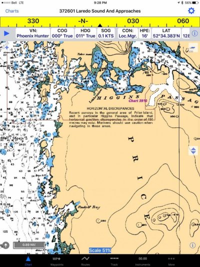
.....WRT to the soundings from the 1920's: they may be accurate, but the positioning of the soundings may have considerable unknown error, perhaps in the order of 100's of yards, while your GPS is accurate to a few feet...


Further to this comment I made earlier, I found this statement on the "still in use chart 3726" (CHS) for the Laredo Sound

IMG_1974.jpg

While there are more recent data for Higgins Passage (CHS 3910) the areas around Price Island are still, Ahem, uncertain!

Jim
 
Back
Top Bottom