ICW mileage question

The friendliest place on the web for anyone who enjoys boating.
If you have answers, please help by responding to the unanswered posts.

JiminGA

Newbie
Joined
Jan 25, 2010
Messages
2
A basic question for you guys:

I read many articles about various locations on the ICW that say something (a marina, etc) is located near mile marker 200 or 300, etc. I realize mile marker zero is in Norfolk, but when on the ICW I just see markers (even and odd) that start over at state lines.

Where do I find the "big picture mileage" along the Atlantic ICW?
 
Some states actually do have mileage signs...but you really just need to follow along and know where you are on your chart.
 
A basic question for you guys:

I read many articles about various locations on the ICW that say something (a marina, etc) is located near mile marker 200 or 300, etc. I realize mile marker zero is in Norfolk, but when on the ICW I just see markers (even and odd) that start over at state lines.

Where do I find the "big picture mileage" along the Atlantic ICW?
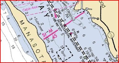
On the ICW charts the mile marks are noted by a line across the route with the mile noted. The charts are noted in five mile increments. Notice that it is marked in statute rather than nautical miles. You will see some mile mark signs posted along the way, but most have disappeared. Some markers with have the mile on them. You will get familiar with the mile marks fo the major stops along the way. The ICW is long, but it will become a small world kind of thing.
 
There are a half-dozen intracoastal waterways defined on NOAA charts. Each one has mile marker designations which, in my opinion, are becoming less meaningful as electronic charts are used more.

The major "ICW" is the Atlantic ICW. It starts at MM0 in Norfolk and continues without restarting until Key West near MM1240. The section south of Miami is more informal but it is still defined.
 
Go to Cruiser's Net and pull up the charts and on the charts are the Statute Miles and increase going north to south. I think this is what you are looking for.
 
A basic question for you guys:

I read many articles about various locations on the ICW that say something (a marina, etc) is located near mile marker 200 or 300, etc. I realize mile marker zero is in Norfolk, but when on the ICW I just see markers (even and odd) that start over at state lines.

Where do I find the "big picture mileage" along the Atlantic ICW?
You're not talking about the navigational aids are you?


The ICW isn't marked like Interstate highways. At best you might see mile markers every five miles but in reality, there are not a lot left.

Charts usually have a line every five miles. If you know where you are on the ICW you can tell what marker you are closest to by viewing the chart.
 
They look like this on a chart:
 

Attachments

  • ICWMM.JPG
    ICWMM.JPG
    36.3 KB · Views: 1,446
Last edited:
Thanks guys - good info!

rwidman, just to answer your concern'question, I was NOT referring to navigational aids but the "big picture" mileage that is discussed in some articles. BTW, I think you and I have traded some PMs on THT as I complemented you on your boat and was asking questions about it. I think I've seen you out and about in the "lowcountry" on the ICW. We are in Hilton Head but do get up your way too :thumb:
 
Our technique is to get underway early , breakfast underway and look over the charts to finfd our next stop spot.

Usually by guessing that 60 miles will be enough we look about 60 miles out and see whats avilable .

We also look at 50mi (for sleeping bridge tenders) , and 70 miles as sometimes current pushes , tho it cant be planned.

In the PM we chose the stop spot for that day , and when we get there its time!

There are very few sections of the AICW where this casual technique doesnt work, and you know within the first hour if its going to be a 30 mile day . to avoid a 90 mile day.
 
I'd only suggest that traveling by mileage is missing the best things about the whole ICW experience. We're underway now. Today we're moving 25 miles to visit with a friend. Tomorrow we'll be going a whopping 9 miles and staying a week. We never fire up our engines without knowing where we're going over the next few days to a week as well as having written down backup destinations to handle the unexpected things that come up. I'm not saying that's a better way to go, but I think you get to do the things you want to so that way in much safer way.

Don't underestimate the dangers of this endeavor.

We're more like you although we tend to cover longer distances faster and skip places to catch them next time or on the way back. However, before the trip we have a list of places and things to do in each. We don't commit to specific plans but do a tentative plan and reevaluate along the way. We take our notes to bed with us and talk at night about the next few days even. We have our can't miss attractions and our others.

This last week we stayed in Sarasota an extra day but we already had a list of things to just pull out and choose from. We added Captiva into our plans. Now in Naples. We just finished on Tuesday our plans for our PNW and Alaska travels. May, June, August, and September each place, the attractions, restaurants, notes of alternative places. What we would skip if we had to, what we'd add. And once we start we'll always be looking at the next few days and reevaluating.

But that's just our way. It works for us. Others prefer to go with fewer plans. What we find by doing it this way is that we're never caught at the last minute trying to figure out an option. If we have to pull up short of our next target, we know what marinas we'd choose from and even what we'd do in town there. It's never a mad scurry to Active Captain or Cruisers Net and Waterway Guide as we collected the information already. So we did it in quiet convenient times and not in a hurry or under any pressure. Oh and as part of that we also have our fuel notes. Both availability and speed. Fueling speed is one thing that we find is not available so we make calls or go from experience.
 
..rwidman, just to answer your concern'question, I was NOT referring to navigational aids but the "big picture" mileage that is discussed in some articles. ..........

I just wanted to be sure. I'm only familiar with the AICW and what mile markers still actually exist on the waterway don't reset, they start in Norfolk and end in FL. There are so few I have never found them to be of much use.
 
We travel pretty much the way FF described. Since you don't know how far you'll get each day you can't plan much beyond that day. You have to keep in mind that there are a few areas where you have to make a choice to stop now or keep going for a couple hours.
 
As long as you boat runs reliably...you can plan down to the "T" pretty well or go with the flow....as people have said...it all depends on what you want...some day though you gotta make the distance or destination...usually no big deal if you can multiply and divide.
 
You have no control over the currents, no control over the wind, no control over the tide and you have no control over the weather. You have no control over bridge schedules, other boats or no-wake requirements. There are some bridges where if you miss an opening the next one isn't for two or three hours. Some bridges won't open at aall in high winds. There are a couple places on the AICW where the military can close the waterway for hours. If you don't make your destination the first day, every day after that is thrown off.

It's been said that the most dangerous thing you can have on a boat is a schedule. I would say that's a pretty accurate statement.
 
Wind rarely bothers me on a trip...Ran Bogue and crossed Pamilco today with Gale Warnings...3 footers really shouldn't affect a schedule unless you have to take them on the beam for the whole day...even that can be adjusted for.

Tides are rarely an issue for boats drawing less than 5 feet if you stay in the channel and follow the current warning from guides/Active Captain.

Tidal currents only affect a schedule in a few places and where they do you can adjust speed or skip an inlet, etc...sure they can be worked around.

North of central Florida....the worst set of 4 bridges starts at Wrightsville to Onslow Beach Swing and can be fairly well timed...just did it yesterday and only lost about 1/2 hr and that can certainly be accommodated in my 6.3 knot boat. It's usually easy to plan around the bridges...I've never waited more than an hour because I just missed one. If you can't make one that has funny closer regs due to rush hours...you just schedule around that....have never been a problem for me in dozens of deliveries in all kinds of boats including sail.

At 6.3 knots my wake never changes or threatens no wake zones...so my speed all day is very predictable...the faster the boat the more adjustments you have to accommodate unexpected slowdowns.

Camp Lejune is the only place I know of that closes the ACIW. I've only been caught for 1/2 hour once there and that's because it was my first trip and I didn't check first (Give Captain Paul at Swan Point Marina (St. M. 247, (910) 327-1081, A SALTY SOUTHEAST CRUISERS’ NET SPONSOR).

I'll stick to the philosophy that the run can be done as quickly and efficiently as you want it (on schedule)...or as leisurely and non-planned as you want it. Only a foolish captain doesn't plan weather/maintenance day(s) or slowdowns into a schedule anyway.

The most dangerous thing on a boat is the captain...not the schedule....one is always easier to change.
 
Last edited:
When underway I always have a multitude of potential stops planned. Some days I get tired sooner than others. As a soloist, having lots of places to stop makes for safer boating. And yes, a two mile day is not unheard of -- just to move to a prettier spot, or something intrigues me so I drop the anchor for a couple of days and relax, take care of boat projects, etc.

For me a Long day is 25 miles so obviously I'm not setting distance records. Being rested for me means that I'm less likely to make a mistake, and that's more important than a 50 mile day -- which for me would be ten hours. Physically a ten hour day won't happen, at least not without a nap in the middle of the trip! :)
 
The last few posts highlight two truths.

First, some of us are organizers who have to have things pinpointed in advance. And that is possible. Tidal information is available. Bridges work on schedules. Weather forecasts are of some value. But there are others for whom that much organization and detail isn't in their basic makeup and would lessen their pleasure of boating.

Second, some like to go strong, barrel ahead, keep on the move, cover large distances. Others are happy going very slowly, spending lots of time in places, moving short distances.

The important thing is just knowing yourself. But also based on your preferences, have an idea of how you would handle situations that arise. It's still important to at least know your options. Know your safe havens. Know what you can do if things don't go as you anticipated.
 
And some captain's can and do both....for the right reasons ....but both ways aren't always possible or desired.

But one camp shouldn't say the other is right or wrong...safe or unsafe....
 
Tidal information is available.

True , but in many tidal areas with inlets every few miles it would take a super computer to plan on knowing when and where the tide is favorable or sucks.

Easier to keep on putting , and enjoy the day.
 
Tidal information is available.

True , but in many tidal areas with inlets every few miles it would take a super computer to plan on knowing when and where the tide is favorable or sucks.

Easier to keep on putting , and enjoy the day.

True....but there's a few places...but relly only if you are going less than say 8 knots...you start at 8 and go up from there...the currents are a much lower percentage of your worries. If you are a 5-6 knot boat....then yes you better get in the mindset of whatever they bring...but a few areas you can easily plan against the really bad foul currents.

Notrhbound up the Waccamaw River (Georgetown to Myrtle Beach) or Cape Fear River (Southport to Snows Cut below Wilmington, NC) you don't want to fight an outbound spring tide and regular river current if you can help it.

Also just south of Charleston in Elliot Cut and the Stono River....a strong current and back flow against you can start or finish a day on a really slow bell when you lose 2-4 knots for a large chunk of the day.
 
...... in many tidal areas with inlets every few miles it would take a super computer to plan on knowing when and where the tide is favorable or sucks..............

That is correct. A trip from Charleston to Beaufort, SC will have the tidal current reversing seven or eight times. North is no different. Looking at a chart will make this pretty obvious.

I usually keep a constant 2,000 RPM which gives me about seven knots over water. Over land I will see (on my chart plotter) anywhere from below five knots to above nine knots. And this change can occur in just a couple minutes.

I'm not delivering boats, passengers or cargo, I'm cruising for pleasure. I start when I want to and I stop when I want to (keeping in mind the limits of where I can and cannot stop).
 
I find that for the most parts tides cancel out. If you are being pushed toward an inlet, when you pass it you will be running into the current. Like PSneeld said there are some long stretches like the Waccamaw and Cape Fear that it would be better in a slow boat to play the tides. Elliot Cut can be wild when a lot of traffic is running through there.

In a slow boat what you do need to watch carefully are the side setting currents near any inlet to the ocean. They can sneak up on you.
 
Last edited:
I find that for the most parts tides cancel out. If you are being pushed toward an inlet, when you pass it you will be running into the current. .............
You would think so and they probably do over a season, but I can look back and see where it took me X hours to get from home to someplace and X+2 or X-2 to get back or to get there or back the next time.

I understand that some people's experiences may be different from mine but that doesn't mean what I experienced did not happen.
 
Maybe I'm missing something...but I'm familiars with captains that plan a destination for the night and call it a schedule...not necessarily down to the hour.

I'm rarely an hour or maybe 2 (at tops) late or early on a planned 8 hr day in a 6 knot boat.

So being held back by current, stopped by a bridge or two or whatever....there has been only 2.5 days I've ever missed a movement day/departure time to get to a planned stop because of weather

One was because of gale force winds blowing down Albemarle so I laid over in Coinjock.

Another lost half day was because the alligator river bridge wouldn't open because of 40 knots gusts and tornado watch....plus backing 200 feet in a narrow channel with a new to me single with no thruster delayed me almost as much as the bridge...but had I been on a different dock...I wouldn't have lost that day.

The third I was pinned to Hazzard Marines face dock in Georgetown due to a norther blowing 25G35 and they crammed me between 2 other boats with just feet to spare. Again had I been at Harborwalk Marina...never would have lost that day. From now on, weather won't hold me up in those 2 places and hasn't this year as I'll be watching what tomorrow morning wx does for my departure strategy.

I would say 2.5 weather days in dozens of trips between Florida and Jersey over 15 years ain't bad....maybe it's planning...maybe it's luck...mabe it's skill enough to mitigate whatever the weather might be.

No other manmade delay has really slowed me down. Maintenance is a different story...especially on some deliveries...none so far in my boat in nearly 6 thousand miles.

Even so I still plan a weather/maintenance day in every 10. If the day isn't used I shorten a couple days or just add in an additional, fun stop.

Since leaving FT Pierce, Fl...I've already had a couple small changes...mainly due to changed interest...but like last night...a rare 3 day weather window of nearly perfect weather came up while in Oriental.....so now instead of sticking to the ICW...we are going to head out to Hatteras tomorrow morning and follow that with a stop in Manteo. So changes in a 45 day return trip home can still be made if you plan in a couple days here and there or add/subtract some time here and there...if you want to.
 
Always encountering tidal currents of 1.5 to 2.5 knots, flooding or ebbing, here. ... Riding a flood lasts longer than an ebb here. ... Tide tables are only theoretical estimates and not to be unquestioned.
 
The point I was attempting to make in post #15 is; I'm planning a trip. From my home marina I can make it to point "A" or point "B" depending on what time we leave the marina and currents and wind and possibly passing situations where I will be stuck behind a slower moving boat until it's safe to pass. Point "A" and point "B" are perhaps two and one half hours apart with no good anchorage in between.

Not knowing where I will be starting from on day two means I can't reliably say where I'll end up that day. We may again be in an area where stopping points are two or three hours apart. Not knowing where I'll be starting from on day three means I can't say where we will end up that day and so on

I realize I could run a tighter schedule and push on even when I'm tired but that's not why we cruise. Other folks may not have that luxury or just be to "organized" to operate this way.
 
Lots of diffident way to enjoy the water, as these posts point out.

OP, when you go, run your own race, your own way, go when you are comfortable and above all enjoy!

Late last year l departed Chesapeake bay and headed south, not having been south of NORVA with a big boat ever, it was a true adventure and I found it to not be that difficult. Made it safely to JAX, with nary an issue........

The guys and girls on the forum were a big help along with the Active Captain app.

Enjoy!

Hope to see you out there!
 

Latest posts

Back
Top Bottom