$5,000 to spend on NAV system?

The friendliest place on the web for anyone who enjoys boating.
If you have answers, please help by responding to the unanswered posts.
I think the summary of this thread is that everyone generally likes what they have and recommend it. Every major brand seems to be good. I would be very aware that you will not use 90% of the features you have available..

I agree.....There are bells & whistles on my radar and chart plotter that I have never used. The same is true with the fish finder.
 
Personally, I don't want to run around with my hand bearing compass and pencil all day.

I don't think anyone was implying we should.

Over the past bunch of years there have been some newsworthy boating accidents here and in BC in which upon investigation the boat was found to be equipped with the electronics bells and whistles but person driving knew little other than the very basics. Mark a line on the plotter from here to there and follow the line, that sort of thing.

No knowledge of chart symbols, no knowledge of the Colregs/rules of the road, no knowledge of much of anything other than how to put a "here" point in the plotter and a "there" point, and then drive the little dot down the line.

Given that some of these accidents killed people, in one case a lot of people, it raises the question, "is a rudimentary knowledge of how to program and follow the electronics sufficient for navigating a boat?"

And I think that's what the posters who brought up paper charts and compasses and whatnot were after. Is a working knowledge of how to operate the electronics enough? Will that cover all the challenges a boater can face in getting a boat from A to B via C without hitting anything that's not water? Does that boater have sufficient knowledge to modify a navigation plan if weather or bad visibility start taking Plan A apart?


The old way of navigation is the basis for the new way. The new way just makes the old way more accurate and user friendly.

If you learned how to write (articles, books, scripts, whatever) using a manual typewriter and then someone gives you a laptop with Word on it, it can make you a better writer because you are more inclined to make changes and improvements and try different things because it's so easy.

But if you don't know how to write and someone gives you a laptop with Word on it, having that fancy electronic "writin' machine" isn't going to make you a good writer because you have no foundation in the skill.

Not sure if that's a good analogy.

But the original poster did not say what his background in navigation is. Perhaps he's really up to snuff with charts and dividers and compasses and he simply wants some suggestions as to how best to bring his boat up to a good electronic capability.

Or perhaps he's bought a boat with a lousy or no radar and he's loaded Navionics on his iPhone and he's trying to learn navigation with them.

If it's the latter the suggestion to get a solid foundation in the basics of navigation is, I think, a good one. If it's the former then the suggestions to forget all this other crap and get a good Furuno setup right off the bat is, of course, the best one.:)
 
Last edited:
Geez, the guy asks for opinions on some electronics and gets an idiot lesson implying he doesn't know how to navigate.
Hey Buddy...RELAX! No need to get abusive and start calling people "idiot." I suggest we keep these exchanges civil, regardless of how we may disagree.
 
Geez, the guy asks for opinions on some electronics and gets an idiot lesson implying he doesn't know how to navigate.
Hey Buddy...RELAX! No need to get abusive and start calling people "idiot." I suggest we keep these exchanges civil, regardless of how we may disagree.
that's not what he was sayng.... in fact he was sticking up for the guy saying those who said "learn to navigate" were the problem....:D

Man this place is entertaining....:thumb:
 
Last edited:
Amen brother. Just hope civil discourse prevails. Much more enjoyable and useful. Otherwise that other kind of entertainment is best left to Jerry Springer, ha! Anyway, maybe it's time to start a new thread on the importance of navigation basics, or some such?
 
Amen brother. Just hope civil discourse prevails. Much more enjoyable and useful. Otherwise that other kind of entertainment is best left to Jerry Springer, ha! Anyway, maybe it's time to start a new thread on the importance of navigation basics, or some such?

With the dozens of basic Nav courses on line I think they are the best place to start as they are pretty well standardized on the basics...

There are so many ways and experience levels of navigating by those most active here...I think would confuse and scare most newbies...:eek:

Just agreeing on what and how to use basic electronics will confound most reading this thread....:D
 
Not just bells and whistles

I agree.....There are bells & whistles on my radar and chart plotter that I have never used. The same is true with the fish finder.

I would normally agree -- if features and quality were the only differentiators. In this case however, the 3G/4G radars operate quite differently than any other radar for the recreational market. I didn't buy the Simrad because it had some questionable chart plotting feature, or because of Navico's pathetic attempt ride the coattails of cellular marketing hype (i.e. broadband and 4G) I bought it because it can show me things within 10-20 feet of the boat. With this radar, I can easily navigate a narrow channel or pass in the dark, or fog. I could even navigate to my slip in the marina with it. It's that good.

To me, the performance difference between FMCW radar and pulsed radar is like the difference between modern depth sounders and the old flashers. The pulsed radars may work better for longer distances, I can't yet say, but I don't have any problem seeing the shore many miles away. The 4G is supposed to be better than the 3G in this regard.

For bluewater cruising I might offer a different opinion, but for rivers and inland waters, as described by the OP, I think the Simrad radar is worth a look.
 
Personally, I don't want to run around with my hand bearing compass and pencil all day.

However if you dont do it on occasion the first fog with a blown fuse may be a lot less fun!
 
All such great stuff, and funny too at times.*

Martin says; *"forget all this other crap and get a good Furuno setup right off the bat is, of course, the best one."*

As far as what to get - get the best you can afford. My opinion (everybody has one) you can't get any better than Furuno. I am currently right in the middle of a complete electronics upgrade. In the 60's and 70's my boating was central Florida rivers and lakes. 1% of the time electronics of the future would have been helpful. Since the late 80's the Florida west coast opened my eyes.*

Standing in a West Marine store looking at charts one day a guy next to me says; "excuse me, but can you tell me what all those little numbers in the blue area mean?" He told me how he came under the Tierre Verde Bridge (Tampa Bay) heading east and saw the Skyway bridge to his right, ignored channel markers (like he had a clue anyway) turned his newly acquired 28-footer toward the 'scenic view' ran about 200 yards at 30 knots before skidding onto a bar 6-inces below the water line.*

My own experience with Raymarine... I believe in redundant systems. In my previous 40-ft sedan I had an E-80 and E-120 at the helm. One goes down I have the backup, right! Until one day running back from a trip I've entered Tampa Bay and punch up a trusty waypoint exactly in the middle of the skyway bridge. Halfway between the gulf and the bridge I'm hit with a heavier than expected rain. Saw it coming and could also see that it only covered about 400 sq yards (gotta love Florida weather). As soon as I hit the rain I saw my radar start going to a complete white out. Why am I now installing Furuno? You should have been at the helm with me while I tried to recall the 4-button menu series to declutter my radar. At that moment I said never again. Sure seemed easy to find while sitting at the dock.*

We have only had our trawler a bit over a year now. But we plan to make great use of her 3,000 mile range and use previous experience for upgrades. We are outfitting as follows; Two Furuno chart plotters in pilot house and one at fly bridge. All with overlay 12kW radar. Plus Nobeltec backup in pilot house with Koden stand alone radar. Furuno AIS transceiver, Icom and Furuno VHF's in pilot house and two icom's on bridge and SSB. Not to forget having on board every well worn chart of everyplace I've ever traveled.

The compass and pencil comment was a bit tongue and cheek... After days or weeks of trip planning, I'll paper chart plan the night before and early morning of my planned day of that travel segment. Then make sure every twist, turn, etc., is charted in plotter. Then, and only then, do I relax and rely on my systems. I will follow my paper chart continuously while relying on my electronics to accurately get me from A to Z.

Does any serious boater not do the same? I don't have the knowledge or experience of many on this forum, but damned if I'll allow myself to get caught in god forsaken nowhere with my pants around my ankles.
 
In the rain situation as outlined above, the new generation Raymarine has a much simplified buttonology- touch menu, touch rain, and you're in business. I believe any of the new MFDs function in a similar fashion.

IMO, there will be a continuous learning curve on any MFD- it's the price to pay for so much functionality packed into small footprints. The key is to have a good grasp of the basic buttonology for normal steaming.
 
All such great stuff, and funny too at times.*

Martin says; *"forget all this other crap and get a good Furuno setup right off the bat is, of course, the best one."*

As far as what to get - get the best you can afford. My opinion (everybody has one) you can't get any better than Furuno. I am currently right in the middle of a complete electronics upgrade. In the 60's and 70's my boating was central Florida rivers and lakes. 1% of the time electronics of the future would have been helpful. Since the late 80's the Florida west coast opened my eyes.*

Standing in a West Marine store looking at charts one day a guy next to me says; "excuse me, but can you tell me what all those little numbers in the blue area mean?" He told me how he came under the Tierre Verde Bridge (Tampa Bay) heading east and saw the Skyway bridge to his right, ignored channel markers (like he had a clue anyway) turned his newly acquired 28-footer toward the 'scenic view' ran about 200 yards at 30 knots before skidding onto a bar 6-inces below the water line.*

My own experience with Raymarine... I believe in redundant systems. In my previous 40-ft sedan I had an E-80 and E-120 at the helm. One goes down I have the backup, right! Until one day running back from a trip I've entered Tampa Bay and punch up a trusty waypoint exactly in the middle of the skyway bridge. Halfway between the gulf and the bridge I'm hit with a heavier than expected rain. Saw it coming and could also see that it only covered about 400 sq yards (gotta love Florida weather). As soon as I hit the rain I saw my radar start going to a complete white out. Why am I now installing Furuno? You should have been at the helm with me while I tried to recall the 4-button menu series to declutter my radar. At that moment I said never again. Sure seemed easy to find while sitting at the dock.*

We have only had our trawler a bit over a year now. But we plan to make great use of her 3,000 mile range and use previous experience for upgrades. We are outfitting as follows; Two Furuno chart plotters in pilot house and one at fly bridge. All with overlay 12kW radar. Plus Nobeltec backup in pilot house with Koden stand alone radar. Furuno AIS transceiver, Icom and Furuno VHF's in pilot house and two icom's on bridge and SSB. Not to forget having on board every well worn chart of everyplace I've ever traveled.

The compass and pencil comment was a bit tongue and cheek... After days or weeks of trip planning, I'll paper chart plan the night before and early morning of my planned day of that travel segment. Then make sure every twist, turn, etc., is charted in plotter. Then, and only then, do I relax and rely on my systems. I will follow my paper chart continuously while relying on my electronics to accurately get me from A to Z.

Does any serious boater not do the same? I don't have the knowledge or experience of many on this forum, but damned if I'll allow myself to get caught in god forsaken nowhere with my pants around my ankles.

Depends..if you are a very well practiced navigator, 99% of all cruising situations it would be hard to get into situations where you really need all that equipment or actually have to compass/chart/stopwatch. In fact most boaters would be in a dire situation because actually getting a set and drift soon enough to keep them off the rocks/shoals is very difficult in many situations.

I've been back and forth to Florida numerous times and some have been with nothing more than a handheld gps and paper charts. No Radar, chartplotter, fishfinder....

I'm now on a several thousand mile/4 month trip with a laptop, fishfinder/gps (not chartplotter).

If I had a total 12volt failure...only on a handful of days would even the most simple/short term plotting would be done...if I cant see 1/2 mile and the plotting waters are less than 5 mile stretches/or that wide...I'd probably just anchor. But in dozens of trips up/down the intracoastal...again those days are few and far between.

Offshore there's even less of a need for fancy electronics. Sea buoy to sea buoy a handheld and a backup is all you need.

Don't get me wrong...the best is great and if you have the bucks...go for it...but enjoying cruising isn't dependent on most of it.
 
Last edited:
Thank you all. I have completed some research and the plot thickens. I also want to upgrade sound system and I see where the sound system can now be integrated with chart plotter. Go figure.

I am leaning toward Simrad as it is feature rich but has a touch screen with user friendly interface (not that others don't). At any rate, I will be attending the Seattle boat show as suggested and spend one of the days comparing and researching. Thanks again.

Sam
 
.....I'll paper chart plan the night before and early morning of my planned day of that travel segment. Then make sure every twist, turn, etc., is charted in plotter. .....I will follow my paper chart continuously while relying on my electronics to accurately get me from A to Z.


That's more or less what we do if we are going somewhere new that we have not already entered a route to in the plotters. If we're on a multi-day cruise we'll figure out and enter the next day's course the evening before. We usually use the older plotter with the large screen to figure out the route and then we enter the same route into the other plotter.

We usually first use the paper charts or chartbook to get the big picture of how we want to get somewhere. And underway we have the relevant paper chart or chartbook page open as a "big picture" check.

However, while we wil continue to have the paper charts out just because we both like paper charts, we are delegating the "big picture" function more and more to an iPad with the Navimatics chart application on it. We don't use it for actual navigation, just as a good chart display we can zoom in and out on, pan around, etc. with a few finger swipes.

Routes that we find we use a lot I'll usually take the time at some point to plot on the chartbook charts with the compass headings to hold in each direction beside the course lines just so we have a fall-back in case the electricicals stop holding hands. Never had to fall back on this yet but you never know......
 
No paper charts for me

I don't use paper charts! Why would I?
There is no way anyone could plot your position on a paper chart using a hand bearing compass or dead reckoning or with a depth sounder as accurately as a chart plotter can.

In the areas I cruise of the GICW, exact positioning is necessary if you plan on cruising and anchoring in the very shallow areas and narrow channels we do. Before electronic navigation you stuck to the marked channels or carefully plotted and estimated your distances between markers if you left the marked channels or you had local knowledge. Now with a chart plotter you can decide to anchor at a beautiful spot as you pass it without having to take the time to determine on a paper chart if it's even possible to get to.

When we were in the Bahamas last year we anchored off the south end of Great Sale Cay with a stronger than predicated southerly breeze. We soon decided we could not get a good night sleep here bouncing around. So I looked at my trusty Garmin chart plotter and found a spot 5 miles away on the west side of the Cay with a slight indentation that looked protected from the southerly breeze. Only problem was a shoal area that extended out from the Cay about a mile that had to be avoided. No problem we just cranked up the ole trusty Cummins headed for the new anchorage and avoided the shoal by about 100 yards. 30 minutes later we were sipping rum and cokes at out new very smooth anchorage. Had we had to paper chart our way to this new anchorage we would have had to estimate our distance from the shoal by taking cross bearings and reading the depth. That's a real pain in a bouncing boat. Ever try an bring out a chart when you're doing 18 kts!

Yes I do carry paper charts but have never had to refer to them. I also carry 2 hand held GPS's in addition to the 2 chart plotters on the helm and the navionics on my cell phone.

As to the original posters question: Any of today's plotters will more than do the job. The bigger question is what are your preferences. Personally I love my Garmin touch screen. I'm not advocating Garmin but I really do like the touch screen and if you're going to use the chart plotter over several years personally I think that option is worth the extra cost. Just my opinion.
 
I just got back from the boat show, comparing radar electronic charters and VHF. With. DSC and AIS that can receive and send. You can mix as most band components can integrate with most other brands. Garmin and Raymarine were the two brands that have all the components. Raymarine was several grand lower than Garmin.

I am going back tomorrow with two of me sons and compare features and best bang for the buck. 15 years ago we up graded with Rayathon which are still working, so we are all ready Raymarine based.

If I was going with different brands I would go with Furuno radar, Noboltec ps charters and ICOI VHF with AIS.
 
I don't use paper charts! Why would I?
There is no way anyone could plot your position on a paper chart using a hand bearing compass or dead reckoning or with a depth sounder as accurately as a chart plotter can.


When we were in the Bahamas last year we anchored off the south end of Great Sale Cay with a stronger than predicated southerly breeze. We soon decided we could not get a good night sleep here bouncing around. So I looked at my trusty Garmin chart plotter and found a spot 5 miles away on the west side of the Cay with a slight indentation that looked protected from the southerly breeze. Only problem was a shoal area that extended out from the Cay about a mile that had to be avoided. No problem we just cranked up the ole trusty Cummins headed for the new anchorage and avoided the shoal by about 100 yards. 30 minutes later we were sipping rum and cokes at out new very smooth anchorage. Had we had to paper chart our way to this new anchorage we would have had to estimate our distance from the shoal by taking cross bearings and reading the depth. That's a real pain in a bouncing boat. Ever try an bring out a chart when you're doing 18 kts!

Yes I do carry paper charts but have never had to refer to them. I also carry 2 hand held GPS's in addition to the 2 chart plotters on the helm and the navionics on my cell phone.

.
Timjet...

What I think most skippers here do is use ALL tools at hand to Navigate. You didn't mention it but I hope you had your radar running when you made the move mentioned above. I have seen MANY times first hand when sole use of the electronic chartplotter would of put the boat on the rocks. The entrance of a popular Canadian Marina was off position on a Garmin software on a friends boat. Had I not been doing a radar watch, while the skipper was doing his best to enter this port in total darkness, with sideways rain in 45kts of wind, and had I not been forceful in my objection to the course the boat would of died that night on the rock jetty.
On my recent trip down to Mexico, Isla San Benito has a pass that is off by over 1/4 mile. The plotter showed that our course went over the island. On the same trip we always kept a chart for the area open that we plotted position hourly (most of the time we were over 20 NM off shore ). The idea is to know where you are If the black box decides it's time to take a nap. I am as much of a tech nerd as anybody here.. but I use paper charts along with the Electronic ones.. just like I carry PFD's and a life raft .. along with every other safety gear... just in case. At some point it will be wrong .. or quit when you really need it.
HOLLYWOOD
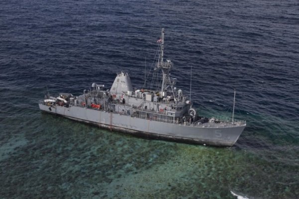
Oh by the way these guys were relying on electronic charts.....
 

Attachments

  • navy ship.jpeg
    navy ship.jpeg
    81.2 KB · Views: 87
Timjet...

What I think most skippers here do is use ALL tools at hand to Navigate. You didn't mention it but I hope you had your radar running when you made the move mentioned above. I have seen MANY times first hand when sole use of the electronic chartplotter would of put the boat on the rocks..

We haven't discussed the accuracy of electronic charts and you make a very good point. I can't defend my use of electronic charts when those charts are not accurate as I have seen this too. I believe the positioning data received from the gps system is dead on, but if the charts being used to show that position are in error then you're better off turning your gps off. In my limited experience in comparing paper and electronic charts, the paper charts are correct and the electronic ones are off.
My observation is the CMAP charts used by Ray Marine are more accurate than the Garmin charts. I'm not sure that's a fair assumption, just one observation I had comparing the two charts on the west coast of FL.

You make a valid point.
 
Last edited:
One reason we selected Furuno's NavNet VX2 was its use of C-Map charting. Our older Echotec plotter uses C-Map as does our handheld Magellan plotter and the new Standard Horizon plotter we put on our fishing boat the other year.

So far C-Map as proven dead on accurate everywhere we've gone in this area. We keep paper charts at the helm in the form of the big Maptech and Canadian chartbooks and refer to them a lot to confirm the plotters, particularly in narrow passes and channels. So far everything has been in agreement.
 
Hopefully charts will continure to improve at an accelerated rate.

I'm not sure why some even well traveled, populated areas still have such major errors in them....so I'm very leary of using a chartplotter to solely tell me where depth or land is....using it to find an aid to nav that someone has placed with GPS is a different story.
 
Chart plotter accuracy is a huge subject that I would like to understand better. Our 40 sedan's Raymarine plotters often have errors in channel markers. Furuno in our trawler and a friends Garmin unit don't have the same errors. So, comparing three systems I find the Raymarine less accurate here in our local area. I've even had our Raymarine plotter start running backwards or show my boat on a correct course but everything would be rotated about 30 degrees - looks like you are running sideways... No method of running 360 circles to recalibrate will correct that much out of alignment. I discussed all of these issues with a friend who installs commercial equipment for a ships supply electronics company and he said what many on this forum are saying; that all the companies are providing better and better equipment. He added "if you want a system that's always going to be dead on accurate and reliable for years to come to go with Furuno." Even after studying the whole electronics gambit for the past year trying to decide on everything is difficult. But, I have resigned to bite the bullet and spend the extra $$ for Furuno for our Trawler. I've got a new Furuno on the fly bridge but not yet in the pilot house. On our 40 coastal boat I tend to run the GICW or could use radar to stay near or far from shore and find my way. But, our trawler is a different story altogether and a new type of boating for us. We plan to go lots of new places and I really don't need the aggravation of an iffy system. But, back to the accuracy issue... I look forward to learning more on this forum. BTW, the backup plotter we bought to bring our trawler from Charleston to Tampa is a 740 Garmin... Go figure!
 
Chart plotter accuracy is a huge subject that I would like to understand better. Our 40 sedan's Raymarine plotters often have errors in channel markers. Furuno in our trawler and a friends Garmin unit don't have the same errors. So, comparing three systems I find the Raymarine less accurate here in our local area. I've even had our Raymarine plotter start running backwards or show my boat on a correct course but everything would be rotated about 30 degrees - looks like you are running sideways... No method of running 360 circles to recalibrate will correct that much out of alignment. I discussed all of these issues with a friend who installs commercial equipment for a ships supply electronics company and he said what many on this forum are saying; that all the companies are providing better and better equipment. He added "if you want a system that's always going to be dead on accurate and reliable for years to come to go with Furuno." Even after studying the whole electronics gambit for the past year trying to decide on everything is difficult. But, I have resigned to bite the bullet and spend the extra $$ for Furuno for our Trawler. I've got a new Furuno on the fly bridge but not yet in the pilot house. On our 40 coastal boat I tend to run the GICW or could use radar to stay near or far from shore and find my way. But, our trawler is a different story altogether and a new type of boating for us. We plan to go lots of new places and I really don't need the aggravation of an iffy system. But, back to the accuracy issue... I look forward to learning more on this forum. BTW, the backup plotter we bought to bring our trawler from Charleston to Tampa is a 740 Garmin... Go figure!

It's not the GPS signal that's the problem...Raymarine is just as dead on accurate as the rest.....all companies have had antennas with problems...especially years ago when they were 5 channel recievers or less.

It's the charts that are not accurate and I have been at boat shows and compared specific locations for several chartplotters and found that almost all of them wound up odd man out in a certain situations sooner or later.

That's why I'm a big fan of raster scan charts whether on a plotter or laptop computer because I know when a change is out direct from the USCG...but even they are "off" more than occasionally.

I like garmin hardware but not it's proprietary mapping...I'm not saying it's better or worse...just I don't like it on many levels.:angel:
 
Last edited:
3 years ago I was in a similar position, though I was doing a complete electronics refit on my boat. Because of Furuno's stellar reputation, that's what I bought. The then-current product line was the NavNet 3D system. The Vx2 was clearly end-of-life, and I didn't want to buy electronics that were not current. I figured I could trust Furuno to do a good job with the new product line. Wrong.

The NavNet3D has been a great disappointment. The operations, control, and user interface are very poor, especially compared to other products. And it crashes on a pretty regular basis. I've had my plotter crash in pea soup fog entering NY harbor from Long Island Sound, and it takes about 5 minutes to reboot. Not good. And I've had other crashes at almost as bad times. Further complicating things, it would appear that Furuno is done evolving the NavNet3D line and is instead focused on developing the TZTouch line. NN3D is now 5 years old, and they haven't released a software update in over 2 years despite a long list of bugs. From complaints I read, my issues pale in comparison to the problems others have had.

I'm now planning out the electronics for the boat I'm building, and I did some digging to see if I was just being picky or what. After all, probably 95% of the Nordhavn's in existence are equipped with Furuno gear. What I found is that by far the people who swear by Furuno are all using the Vx2. That seems to be reinforced by comments in this thread as well. In contrast, people using NN3D were very mixed in their satisfaction. Some were having no trouble at all, but many were having issues. Amazingly, many new Nordhavn's are still being built with Vx2 system, and I've learned that although Furuno discontinued it a number of years ago, they were forced to bring it back even though it's 2 generations old at this point.

For me, I'm unwilling to buy 1 generation old products, let along 2 generations old, so the Vx2 is just not an option. To keep a long story from getting longer, I'm 90% going with Simrad on my new build. I'm bench testing it now and so far I'm very pleased with it.

You'll have to decide if and how all this impacts your decision. We all have different needs and priorities.
 
Furuno still sells the VX2 although they no longer offer the 7" screen version. We continue to be 100 percent satisfied with ours. Rock solid reliability, excellent cartography (C-Map), and the radar is and continues to be superb. While we've not needed it so far their factory support of all their products with their service center in this state is excellent from what we've been told by friends who've used it.

The plotter is not quite as intuitive as some other systems like the Standard Horizon we put on our other boat the other year. However we think Furuno's approach to the plotter user interface is more intelligent than the Standard Horizon's which sometimes leaves us scratching our heads and saying, "Why the hell did they do it that way?"

But if you use something enough you can get used to anything, even Microsoft Windows.:). But for solid, consistent, reliable performance I think Furuno still tops the list even if there are other systems out there that seem more "cutting edge."
 
Last edited:
You are not alone in your appreciation of the Vx2, and if the original poster decides to get a Vx2 I expect he will be equally happy. However, if the OP prefers the more current NN3D or TZTouch, I suggest they talk to users of those systems, not users of the Vx2. Unfortunately, I think they will hear a different story.

Of all the plotters out there, I agree that Furuno has the broadest chart coverage. But if you are cruising the US, then I'd agrue that all the charts are equivalent since all are derrived from the same NOAA charts. Outside the US, chart coverage starts to make a big difference. In my evaluation of alternatives for my own use, I made a table of all the most remote places I envisioned I'd want to go, and checked the coverage for Furuno, Simrad, and Garmin. Fununo won hands down, with Simrad a close second. Garmin had significant gaps, like no coverage at all for Japan. That said, I ended up taking a different approach (or not so different depending on who you talk to), and decided to focus on using Coastal Explorer as my primary navigation and charting tool. CE's chart coverage is equal to Furuno - actually a bit better. The plotter becomes a central control point for all the nav gear, fish finder display, radar viewing, and radar overlay on a chart. For the radar overlay, I figure I can live with whatever charts the chart plotter offers.
 
For the record Furuno does not have their own cartography (I'm pretty sure). Today they use C-Map which is Jeppesen. They used to offer the NavNet system with either C-Map or Navionics cartography. Today it appears they offer only C-Map.
 
For the record Furuno does not have their own cartography (I'm pretty sure). Today they use C-Map which is Jeppesen. They used to offer the NavNet system with either C-Map or Navionics cartography. Today it appears they offer only C-Map.

For the Navnet3D and TZTouch, the cartography originates from 3rd parties, but is processed into a proprietary format for use with the chart plotters. So it's an odd blend that's "standard" and "proprietary" at the same time. The only way to buy charts is through Furuno and MapMedia which is a subsidiary/partner company. This is something that I gather is different from the Vx2. But the base charts are Navionics or C-Map, They also offer the US raster and vector charts. You have your pick, which is nice since I understand each is better in certain parts of the world. I've used both in Canada and would give a very slight nod towards c-map, but the differences are minimal. All in all, although I don't like the proprietary reformatting of the charts, I think Furuno offers the broadest chart selection of the major plotter vendors. If you are cruising in the US, I don't think it matters much since all the vendors charts are based on the same NOAA charts and are excellent. But outside the US, it starts to matter, sometime quite a bit. Being able to pick best-in-class is important in such a situation.
 
Chart plotter accuracy is a huge subject that I would like to understand better. Our 40 sedan's Raymarine plotters often have errors in channel markers. Furuno in our trawler and a friends Garmin unit don't have the same errors. So, comparing three systems I find the Raymarine less accurate here in our local area. I've even had our Raymarine plotter start running backwards or show my boat on a correct course but everything would be rotated about 30 degrees - looks like you are running sideways... No method of running 360 circles to recalibrate will correct that much out of alignment. I discussed all of these issues with a friend who installs commercial equipment for a ships supply electronics company and he said what many on this forum are saying; that all the companies are providing better and better equipment. He added "if you want a system that's always going to be dead on accurate and reliable for years to come to go with Furuno." Even after studying the whole electronics gambit for the past year trying to decide on everything is difficult. But, I have resigned to bite the bullet and spend the extra $$ for Furuno for our Trawler. I've got a new Furuno on the fly bridge but not yet in the pilot house. On our 40 coastal boat I tend to run the GICW or could use radar to stay near or far from shore and find my way. But, our trawler is a different story altogether and a new type of boating for us. We plan to go lots of new places and I really don't need the aggravation of an iffy system. But, back to the accuracy issue... I look forward to learning more on this forum. BTW, the backup plotter we bought to bring our trawler from Charleston to Tampa is a 740 Garmin... Go figure!

I have the sainted Furuno VX2 system, 1944BB, 1920BB, BBFF. I have grown quite used to, and fond of it after 6 years of cruising with it, but let me warn you, it is not always "dead on accurate". You can be in the middle of a 200 ft wide channel and the boat will be shown driving along the on the road paralleling the canal. The charts need updating regularly, which used to happen annually. That's one reason computer-driven navigation has become popular, it is free and easy a to get up to the minute charts. Oh yes, my Macbook Pro hooked to a Furuno GPS antenna will also show the boat on the ground now and then. It is not the GPS that is inaccurate, it is the cartography and how it mates to the GPS.

While I find the Furuno interface on both Vx2 and 3D to be physically easier to conduct basic functions with, vs futzing around with a mouse and cursor on a PC, I think (not having seen Furuno's newest TZ product) it significantly lags both Simrad and Garmin in user friendliness. Even the new Raymarine stuff is looking much better.
 
The inaccuracy of cartography seems very much tied to locations. Most-- but not all--- of the complaints of inaccuracy, like caltexflanc's experience above, I have read about here and on T&T in the past seem to come from the east and southeast coasts. I have no idea why that is--- maybe just a coincidence.

While never say never, we have yet to see any inaccuracy at all in any of our plotters, all four of which (if you count both boats and the handheld) use C-Map cartography. Obviously we have not taken the boat over every square yard of water in this region. But regardless of where we've gone, which includes some really narrow passes in the islands--- by narrow I mean three or four boat lengths wide----all the plotters have always put the boat exactly where we've seen that it is.
 
Last edited:
Greetings,
Garmin 530S. VERY occasionally inaccurate. Mid east coast USA. Has also shown me on shoreline access road 2X in last 3 years.
 
I don't recall the manufacturer,etc, but 15 years ago, while diving on the Wreck of the Rhone, our plotter showed us about 300 yards up on the beach. In defense of that plotter, the dive leader said that the plotters were often more accurate than the maps. :ermm:
 
Back
Top Bottom