How much HP?

The friendliest place on the web for anyone who enjoys boating.
If you have answers, please help by responding to the unanswered posts.
Yes of course I do plan to run both ways ... elementary as you imply.

I've never been able to get consistent results w the GPS in sea water. Turn around and go the other direction and the speed is different or it will be in a moment. And measuring over a long distance obviously won't be stable so it's off to the lake for me.

Have you gone into the GPS settings and turned on / on/ altered the speed averaging settings? You can dampen the results to get more accurate results, just not immediate results.
 
Off topic, but they make two methods of determining thru the water speed for commercial vessels. A PitSword, and Doppler sensors. So the technology does exist, but not readily affordable for John Q Yachter.
 
Sailboats often suffer from this 'speed abnormalities' in GPS readings. It is because they have the sensor info completely undamped, so when the mast swings around, or wherever the GPS antenna is, it is giving WILD results that seemingly jump all over the place speed wise. (for instance from 6.4 to 6.8 to 7.2, to 6.4 to 6..8 then back down, and up and down and up etc etc etc.)
 
I have 7 different GPS sensors on my vessel and if compared to each other they agree within 0.1 knots at any one time when throttles in same position and no big waves. They never agree on lat lon to the second though - likely because as my eyes can't scan/compare that fast.
 
Last edited:
I've determined boat speed by going up and down current for short distances (3 minute runs to minimize the effect of changing current speeds) at various engine speeds (RPM). Now I measure current by comparing "should speed" (per RPM) to SOG. That's more accurate than theoretical tidal-current tables.
 
I've never been able to get consistent results w the GPS in sea water. Turn around and go the other direction and the speed is different or it will be in a moment..

The problem up here (and all the way up the coast), Eric, is that the current is rarely going the same speed over a very wide area. Even crossing five-mile Bellingham Bay, which we have to do twice every time we go somewhere, the GPS speed-over-ground is always changing. We'll be in water moving at x-speed and y-direction, and a minute or less later we'll be in water that's moving at v-speed and w-direction. Then throw in the effect of whatever wind is present and the whole speed thing becomes kind of a crap shoot.

When we can we take advantage of the current when we are going into the islands. But this sometimes isn't possible, so we end up bucking the currents for much of our route. This can add as much as an hour to our longer runs through the area.

The measured mile on the north side of the 520 bridge is a good tool, but I'm not sure you can use it anymore. The construction of the new floating bridge beside the old one appears to have closed all the water around the north side of the bridge except for the high-rise openings at the east and west ends. And I'm not sure the east end opening is even usable now.

So you might want to drive down and check out the situation before you go to the trouble of going through the locks and stuff.
 
Off topic, but they make two methods of determining thru the water speed for commercial vessels. A PitSword, and Doppler sensors. So the technology does exist, but not readily affordable for John Q Yachter.

Cappy,

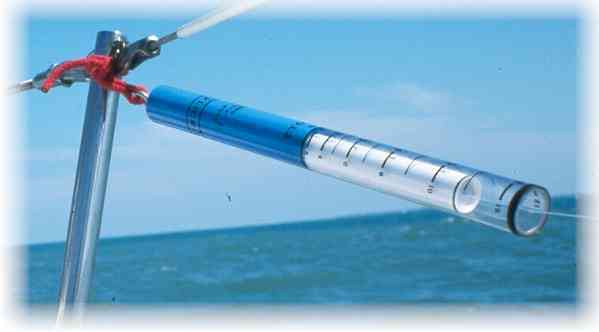
Your post reminded me a tool I used years ago in smaller sailboats. It's called a 'Knotstick' and was very accurate and stable.

k4.jpg


As it turns out, they are still in business, and their speedometer might be a handy way to quickly determine your speed through water with a fairly high degree of accuracy. They read speeds up to 9 knots.

Larry
M/V Boomarang

Thanks.
I'm going to buy one; looks fantastic: KISS! (no not you)
 
Do any of you have your GPS heading and speed hooked up to a chart plotter? if so, have you noticed in a heavy sea, with the boat rocking and pitching that the heading predictor and speed are often varying by 10 degrees, and half a knot? This is because of the damping not being set low enough (or high enough, depending upon brand)

The instantaneous readings sacrifice accuracy over the long run. When viewed from another plotter, that is reading ais (gps derived) data, it is quite obvious who has their GPS set up practically, and who does not.

However, the issue of whether or not there is current (throwing off speed calculations) is a red herring. The speed can be determined practically, using gps, and observing passage of buoys, pots, etc along the way. It does not have to be done all the time, but once in a while to confirm (among other things) barnacle growth on running gear, slimed hull, or (in my case) a base line on a recently purchased vessel. If you do live in a place that has rotary current, then move to a different side of the bay, or passage. it is rare that the current is completely vague all over a body of water.

The mention of current tables being inaccurate is correct. However, in the use to determine where one is in the current cycle, (for instance) in the middle two hours, or the last hour, or the first hour helps confirm the general direction of the current to be anticipated. It is not the amount of current found, but the difference between anticipated speed, and actual, averaged out over the entire trip. running one direction for 15 minutes, and reciprocal for 10 minutes is far more accurate than just running a mile long mark, and guessing what the current was doing.

Every GPS has an amazing tool built in. When you run North and South the number of degrees of Lat are pretty easy to compare for DST calculations. and they even come out to the 3rd decimal place! Unfortunately this wouldn't work so well for an east /west current though. This is one of the great things about our boats. There's as many ways to skin a cat, it makes the mind busy just thinking about it.
 
Also, the mentioned 'measured mile' will give you the same inaccuracies as the modern new fangled GPS! They both give speed over the bottom. Both are irrelevant to prove finite gph measurements.
 
Also, the mentioned 'measured mile' will give you the same inaccuracies as the modern new fangled GPS! They both give speed over the bottom. Both are irrelevant to prove finite gph measurements.

Absolutely correct but if you're on a lake w little or no current and negligible winds for all practical proposes your GPS is the correct water speed.

Thanks Marin I'll check but I want to go to Lake Washington anyway. After being in Alaska for 8 years my cruising destinations will be a bit different for awhile.
 
Interesting thread. It would appear that this SOG thread is a precurser to qualify running these Time Distance Speed events I read about in the Seattle Northwest Yachting magazine.:socool:
What is the importance of minute measurements of SOG using any process? That being asked from the standpoint of using dividers adjusted for the miles scale on a chart, measuring the route as close to the actual trip and use the time run divided into the sum of miles.:blush:
Marin has the more common sense response with his description of crossing Puget Sound. :thumb:
It is the same up here and Erick can attest to it. One minute you would believe you are in a flood tide as tide book predicted only to find you are in a back eddy and dropping speed like a rock.
It just seems fruitless and frustrating to worry over the SOG during the voyage other than what the specific moment reflects. Unless you are into increasing or decreasing throttle to maintain a desired SOG.
On my earlier GPS there was the feature that gave you the distance to a given point (straightest line) and the time to accomplish at the current speed adjusted en-route as the tidal/wind affected this leg. Always seem close enough using that feature or measuring with dividers and using the speed wheel. Old fashion but close enough to make cocktail hour.:hide:

Al-Ketchikan (Bridge to Nowhere) Alaska
 
Sorry- I see that I had forgotten the GPH considerations in the thread. Still all of the data discussed when divided into the gallons of fuel used will result in the GPH number. We do this on every trip along with the SOG all for the general satisfaction as a part of each voyage.
Al
 
Back
Top Bottom