Reply
 
Thread Tools Search this Thread Display Modes
 
Old 08-25-2015, 06:33 AM   #1
Moderator Emeritus
 
jwnall's Avatar
 
City: St. Marks, Florida
Vessel Name: Morgan
Vessel Model: Gulfstar 36
Join Date: Sep 2012
Posts: 3,673
Tropical Storm Erika

Posting today (Tuesday, 8/25/15) by FSU meteorologist Peter Ray:

Friends, Deja vu, all over again.


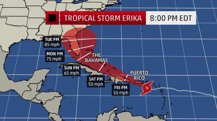
FORECAST: Tropical Storm ERICA so far, is a carbon copy of her brother, Danny, but ERICA will intensify significantly. It will be a few more days before there is enough data available to refine the track and intensity more exactly. This time, expect early recurvature (turning North) , and while Florida may only experience Rip Tides, the Bahamas should be preparing for a hurricane by the end of the week.


DISCUSSION: TS ERICA had the same parents as DANNY and so far, they look like twins separated by a few weeks in birth. However, they are different. Currently 700 miles from anything, but light winds (shear) and warm waters portend significant strengthening. Should reach the Northern Leeward Islands Thursday.


NEXT FORECAST: Tomorrow, August 26th


Peter Ray
__________________
John
jwnall is offline   Reply With Quote
Old 08-25-2015, 07:53 AM   #2
TF Site Team
 
Larry M's Avatar
 
City: Jacksonville
Join Date: Nov 2008
Posts: 11,670
Saturdy and Sunday could be interesting for the Bahamas. And I would keep an eye on SE Florida after that.

Tropical Storm ERIKA
Larry M is offline   Reply With Quote
Old 08-25-2015, 05:08 PM   #3
Moderator Emeritus
 
jwnall's Avatar
 
City: St. Marks, Florida
Vessel Name: Morgan
Vessel Model: Gulfstar 36
Join Date: Sep 2012
Posts: 3,673
Quote:
Originally Posted by Larry M View Post
Saturdy and Sunday could be interesting for the Bahamas. And I would keep an eye on SE Florida after that.
Yup. I agree.
__________________
John
jwnall is offline   Reply With Quote
Old 08-25-2015, 05:36 PM   #4
Technical Guru
 
Ski in NC's Avatar
 
City: Wilmington, NC
Vessel Name: Louisa
Vessel Model: Custom Built 38
Join Date: Jan 2014
Posts: 6,194
Yep, on that course land effects will be minimal, so it can get strong. Got to watch this one.
Ski in NC is offline   Reply With Quote
Old 08-25-2015, 05:41 PM   #5
Guru
 
Moonstruck's Avatar
 
City: Hailing Port: Charleston, SC
Vessel Name: Moonstruck
Vessel Model: Sabre 42 Hardtop Express
Join Date: Nov 2008
Posts: 8,276
I'm pulling for the jetstream.
__________________
Don on Moonstruck
Sabre 42 Hardtop Express
When cruising life is simpler, but on a grander scale (author unknown)
https://moonstruckblog.wordpress.com/
Moonstruck is offline   Reply With Quote
Old 08-26-2015, 07:17 AM   #6
Moderator Emeritus
 
jwnall's Avatar
 
City: St. Marks, Florida
Vessel Name: Morgan
Vessel Model: Gulfstar 36
Join Date: Sep 2012
Posts: 3,673
Peter's Ray's posting for Wednesday, 8/26/15

Friends, Erika is coming


FORECAST: Tropical Storm Erika is 70 miles East of the Leeward Islands and

will get there early Thursday morning, shortly after midnight. From then on Erkia

will gracefully gradually turn North, going over Puerto Rico and brushing by

Hispaniola, providing both needed rain. This weekend Erica will encounter the southern Bahamas, as a stronger Tropical Storm, and continue strengthening.

This is where it gets difficult. Early Monday Erika will either go through the Florida Straights, make landfall in the Miami area as a (NOT major) hurricane, or go up the East coast and maybe hit North Carolina's Outer Banks. It probably will be a couple of days to tell which of the competing steering forces has the edge. At this time, the less aggressive turns look more favorable. But that could change even by tomorrow. But it may be as late as Friday.


DISCUSSION: The storm motion is largely guided now by a subtropical ridge to the north. All the other parameters which hurt Danny are much less a part of Erika's life. So intensification is certain. The actual path depends on, among other things, how much and when Erika strengthen over the next few days. That is what I need to know better.

NEXT FORECAST: Tomorrow morning, August 27, 2015


Peter Ray
__________________
John
jwnall is offline   Reply With Quote
Old 08-26-2015, 07:26 AM   #7
TF Site Team
 
Larry M's Avatar
 
City: Jacksonville
Join Date: Nov 2008
Posts: 11,670
8 am this morning. If it follows this course, Miami has a bulls eye with a Monday am arrival.

Tropical Storm ERIKA
Larry M is offline   Reply With Quote
Old 08-26-2015, 08:35 AM   #8
Technical Guru
 
Ski in NC's Avatar
 
City: Wilmington, NC
Vessel Name: Louisa
Vessel Model: Custom Built 38
Join Date: Jan 2014
Posts: 6,194
Too soon to call. Could still go almost anywhere.
Ski in NC is offline   Reply With Quote
Old 08-27-2015, 07:32 AM   #9
TF Site Team
 
Larry M's Avatar
 
City: Jacksonville
Join Date: Nov 2008
Posts: 11,670
Todays (8 am) projected storm path.
Attached Thumbnails
120138W5_NL_sm[1].gif  
Larry M is offline   Reply With Quote
Old 08-27-2015, 07:37 AM   #10
Moderator Emeritus
 
jwnall's Avatar
 
City: St. Marks, Florida
Vessel Name: Morgan
Vessel Model: Gulfstar 36
Join Date: Sep 2012
Posts: 3,673
Peter Ray's posting for today, Thursday, 8/27/15:

Friends, Nobody seems to like Florida. We need water too. Our aquifers are half-full and half empty. Thankful for the half-full part, but want more. What's new.


FORECAST: Tropical Storm Erika has arrived at the Leeward Islands with winds of 50 mph and headed WNW at 16 mph. Tomorrow morning TS Erika will brush buy Puerto Rico and pass just North of Hispaniola and head to the Bahamas. It will weaken for the next 2 days and then strengthen for the next week, becoming a minor hurricane and just missing Florida's east coast. As stated before. We will have dangerous rip tides and squalls. All this the first half of next week.


DISCUSSION: Too much shear is hurting Erika, but if She can hang-in there for 2 days, that will go away, and next week, waiting warm waters will welcome her (alliteration) and by early next week she will pass Florida on her left. Since this is rather far off, something could happen to alter this, but I think we surly can dismiss the most southern possibilities or the impact of a major storm. The Insurance companies are happy again. Attention will shift to the east coast where lives matter.


NEXT FORECAST: Tomorrow morning, Friday, August 27,2-15


Peter Ray
__________________
John
jwnall is offline   Reply With Quote
Old 08-27-2015, 08:50 PM   #11
Guru
 
BandB's Avatar
 
City: Fort Lauderdale. Florida, USA
Join Date: Jan 2014
Posts: 21,449
Current path has us prepared for a strong storm, somewhat more so than the storms we get periodically but less than hurricane so hopefully rather benign. Obviously a lot can happen between now and Monday so we just stay prepared for whatever turn she takes.
Attached Thumbnails
Erika.jpg  
BandB is offline   Reply With Quote
Old 08-28-2015, 07:08 AM   #12
TF Site Team
 
Larry M's Avatar
 
City: Jacksonville
Join Date: Nov 2008
Posts: 11,670
Todays (8 am) projected storm path.
Attached Thumbnails
115331W5_NL_sm[1].gif  
Larry M is offline   Reply With Quote
Old 08-28-2015, 07:35 AM   #13
Moderator Emeritus
 
jwnall's Avatar
 
City: St. Marks, Florida
Vessel Name: Morgan
Vessel Model: Gulfstar 36
Join Date: Sep 2012
Posts: 3,673
Hmmm. Interesting developments! Here is Peter Ray's take on it this morning:

Friends, There has been a small but significant change to Erica's response to a small change in the evolution of the environment. The result is that the whole scenario has changed, even though it looks like the effects on Florida will not be changed all that much. It also means that the effects of Erika on the rest of the East Coast will be minimal. It also means that is now possible that Erika could enter the Gulf. That would be a game changer.


FORECAST: Tropical Storm Erika is weak Tropical Storm with winds of 50 mph, moving WNW and will go over the Dominican Republic and Haiti. It is quite possible that ERIKA will drop to less than a tropical storm. Erika will get around the western part of the tropical ridge and will turn north. What is significant is how far west Erica is when it turns north and what is left of the storm when that does happen. All this is because the western part of the ridge did not erode as much as anticipated and forced Erica to go further west than anticipated and to endure the shear conditions longer before escaping to warm waters to heal.


DISCUSSION: Instead of turning right, Erika turned left to go around the western edge of a subtropical ridge of high pressure. That has two possible effects. One is it shifts the track significantly to the west. It also means it could well not become a hurricane at all unless it gets at least 75 miles into the Gulf. The NHC has Erica coming right up the Peninsula as a Tropical Storm. This is HIGHLY UNLIKELY. What it does mean, is that it will take a day to sort this all out. Erica is 1/2 through an anticipated 48 hour period of negative weather with significant shear. But the effects were more negative than I had anticipated and the lack of erosion of the western part of the ridge has also played a big part. It probably doesn't change much weather-wise (from what was forecast) with Florida. That is: Rain and Some squalls, particularly in the southern part of the Peninsula.


NEXT FORECAST: Tomorrow morning, August 29, 2015


Peter Ray
__________________
John
jwnall is offline   Reply With Quote
Old 08-28-2015, 07:59 AM   #14
Guru
 
siestakey's Avatar
 
City: Sarasota,FL/Thomasville,GA
Vessel Name: Steppin Stone IV
Vessel Model: Marine Trader Kelly Trawler 46
Join Date: Jul 2013
Posts: 1,815
John

Thanks even though may not be much I think I am heading to Sarasota Sunday afternoon to hang with my boat and batten everything down
siestakey is offline   Reply With Quote
Old 08-28-2015, 08:08 AM   #15
TF Site Team
 
Larry M's Avatar
 
City: Jacksonville
Join Date: Nov 2008
Posts: 11,670
We're on our back to Hobo now. She's on the Ortega River just off the St Johns in Jacksonville. It's the rain and potential flooding we're now concerned about.
Larry M is offline   Reply With Quote
Old 08-28-2015, 08:15 AM   #16
Guru
 
psneeld's Avatar
 
City: Ft Pierce
Vessel Name: Sold
Vessel Model: Was an Albin/PSN 40
Join Date: Oct 2011
Posts: 28,119
Quote:
Originally Posted by Larry M View Post
We're on our back to Hobo now. She's on the Ortega River just off the St Johns in Jacksonville. It's the rain and potential flooding we're now concerned about.
Yeah. tropical storms and Noreasters are just as much as a PIA as a Hurricanes....but usually just a PIA and not as dangerous and deadly.

With the St Johns running through so much low country and permeable surface...I wouldn't think that flooding should affect the boat too much...maybe getting on and off and car parking...but just that.

Know anyone that has rode one out there before?
psneeld is online now   Reply With Quote
Old 08-28-2015, 08:38 AM   #17
TF Site Team
 
Larry M's Avatar
 
City: Jacksonville
Join Date: Nov 2008
Posts: 11,670


This week in front of our gate at the marina. It's been a wet summer. With the St John's running north for almost 300 miles and the projected storm track following the same course who knows what will happen. I was told in 2004 the river was up over 4'. We're on floating docks but the next one up stream isn't.
Larry M is offline   Reply With Quote
Old 08-28-2015, 10:30 AM   #18
Guru
 
psneeld's Avatar
 
City: Ft Pierce
Vessel Name: Sold
Vessel Model: Was an Albin/PSN 40
Join Date: Oct 2011
Posts: 28,119
Quote:
Originally Posted by Larry M View Post

This week in front of our gate at the marina. It's been a wet summer. With the St John's running north for almost 300 miles and the projected storm track following the same course who knows what will happen. I was told in 2004 the river was up over 4'. We're on floating docks but the next one up stream isn't.

ooops...ya gotta hate being totally prepared and watch someone else's issue become yours!
psneeld is online now   Reply With Quote
Old 08-28-2015, 10:58 AM   #19
Guru
 
healhustler's Avatar
 
City: Longboat Key, FL
Vessel Name: Bucky
Vessel Model: Krogen Manatee 36 North Sea
Join Date: Oct 2009
Posts: 5,196
I thought we were getting a break over here on the Gulf side of FL.., but who knows now. I've got Tide Minders on pilings that will take care of surges up to maybe 5 ft. And if it's anything beyond that, I'll throw out the anchors and stay aboard.
__________________
Larry

"When life gets hard, eat marshmallows”.
healhustler is offline   Reply With Quote
Old 08-28-2015, 11:19 AM   #20
Guru
 
BandB's Avatar
 
City: Fort Lauderdale. Florida, USA
Join Date: Jan 2014
Posts: 21,449
I love the headline: Erika Forecast Changes Overnight. What we know now.

That's the problem, they pretend they know. Didn't know before, don't know now. It's what we think now, what might happen now. All we know is the present, not the future of the storm. You can't have what I knew yesterday and then what I know now.

We're having thunderstorms daily anyway so going to be hard to tell when it hits. We were having serious withdrawals from the water so gave in and went out today. A quick trip to West Palm and back. We know we'll probably get rained on but that's ok. Seas are under 2'.

Current forecast is winds at 36 mph and gusts to 61 Sunday with some flooding. Seas Sunday 3 to 5', worsening late to perhaps 6-8'. Sunday night is when Sarasota now has the forecast of 23 mph and gusts to 61.

I guess the thing is never be convinced a storm is going to hit you but never convinced it isn't so always prepare as it is. We had everything ready yesterday. Now obviously the boat we're on today isn't ready now.

Biggest task for us is clearing all the outdoor furniture.
BandB is offline   Reply With Quote
Reply

Thread Tools Search this Thread
Search this Thread:

Advanced Search
Display Modes

Posting Rules
You may not post new threads
You may not post replies
You may not post attachments
You may not edit your posts

BB code is On
Smilies are On
[IMG] code is On
HTML code is Off
Trackbacks are Off
Pingbacks are Off
Refbacks are Off


» Trawler Port Captains
Port Captains are TF volunteers who can serve as local guides or assist with local arrangements and information. Search below to locate Port Captains near your destination. To learn more about this program read here: TF Port Captain Program


All times are GMT -5. The time now is 04:45 AM.


Powered by vBulletin® Version 3.8.8 Beta 4
Copyright ©2000 - 2024, vBulletin Solutions, Inc.
Search Engine Optimization by vBSEO 3.6.0
Copyright 2006 - 2012