You are using an out of date browser. It may not display this or other websites correctly.
You should upgrade or use an alternative browser.
You should upgrade or use an alternative browser.
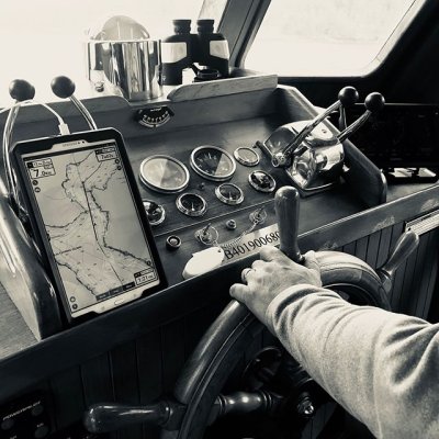
Tablet Navigation
- Thread starter SeaBreeze
- Start date
The friendliest place on the web for anyone who enjoys boating.
If you have answers, please help by responding to the unanswered posts.
If you have answers, please help by responding to the unanswered posts.
dhays
Guru
- Joined
- May 26, 2015
- Messages
- 9,045
- Location
- United States
- Vessel Name
- Kinship
- Vessel Make
- North Pacific 43
How many are using a tablet as their primary GPS Navigation tool? If so have you found any significant limitations?
Not primary but I do use an iPad with a Bad Elf gps dongle. It works great but it really drains the battery quickly and leaving it plugged it barely keeps up with the charging.
I navigated for about 500 miles on a friend's boat using a 10" Samsung Android tablet running MxMariner. Worked fine plugged into a cigarette lighter socket nearby.
My new boat has a tiny Garmin 5" display chartplotter, so I will use it as the backup to my Samsung.
David
My new boat has a tiny Garmin 5" display chartplotter, so I will use it as the backup to my Samsung.
David
Lou_tribal
Guru
Navigated inland on Rideau waterway as well as river with 10” samsung tablet and navionics. Was perfect to me. Loved the auto routing option while preparing my trip.
L
L
NWSeadog
Senior Member
MxMariner on an Android tablet plugged into a cigarette lighter as a secondary. Actually it gets used more then the Navtronics because of its location. No problem with keeping it charged.
Ken E.
Guru
- Joined
- Nov 12, 2016
- Messages
- 1,975
- Location
- United States
- Vessel Name
- Hatt Trick
- Vessel Make
- 45' Hatteras Convertible
I have 2 android tablets with GPS running Navionics that I use as backup and for route planning. They work well in both roles.
Wayfarer
Guru
- Joined
- Aug 29, 2014
- Messages
- 2,228
- Location
- USA
- Vessel Name
- Sylphide
- Vessel Make
- Kingston Aluminum Yacht 44' Custom
I used my phone with Navionics when I've needed a plotter in the past. I had an ancient gps and paper charts, so the phone was my primary. I plan to have a tablet for secondary on my next boat.
nodestination
Senior Member
- Joined
- Apr 28, 2016
- Messages
- 199
- Location
- usa
- Vessel Name
- No Destination
- Vessel Make
- 1972 GulfStar Trawler 36
Cheap ( from wallmart) RCA 10inch tablet. Amazing GPS accuracy, but use a lot of power. OpenCPN with NOOA charts. I have Mxmariner too.
TDunn
Guru
- Joined
- Feb 23, 2015
- Messages
- 889
- Location
- USA
- Vessel Name
- Tortuga
- Vessel Make
- Nunes Brothers Raised Deck Cruiser
I use an Acer netbook with a GPS dongle running Sea Clear. It works just fine. I also sometimes us my 15" Acer laptop with the same dongle and Open CPN, but it can get bogged down in course up mode. The 15" screen is nice though.
Ipad/Bad Elf with Navionics is primary for entering new harbors with numerous turns, or for changing destination quickly. Secondary at all other times. Don't leave it in the sun. It simply shuts down when overheated.
I use my cell phone with OpenCPN, Navionics and MX Mariner a lot when I'm not at the helm. I've used it at the helm when needed, too.
I've tried tablets, but often the screen isn't very readable in sunlight (even under a bimini) or at a less-than-ideal angle. Plus I already carry the phone everywhere.
I've found you can't have enough USB outlets on a boat. I have four at the upper helm and there have been times when they were all occupied, for weeks on end.
Jeff F
Guru
- Joined
- Nov 5, 2015
- Messages
- 2,437
- Location
- Canada
- Vessel Name
- Escapade
- Vessel Make
- 50` US Navy Utility trawler conversion
I have a Garmin plotter on the flybridge and an old Android 8" tablet running Navionics semi-permanently mounted at my lower helm. I like the tablet and the charts seem to have slightly more detail than the Garmin. But to be fair the Garmin is 5-6 years old and I haven't updated the charts. I have C-Map as well but haven't used it much.
ben2go
Guru
I did a write up for a forum dedicated to GPS many years ago. I set up a laptop with GPS that ran pre-downloaded Google maps/Google Earth. It was meant as a backup nav aide. At that time, there was no marine info on the Google set up. It would help someone get to where they needed to be or check position. Nothing better than up to date paper charts when the electronics take a poop in the middle of a voyage. Of course, my opinion only.
Jeff F
Guru
- Joined
- Nov 5, 2015
- Messages
- 2,437
- Location
- Canada
- Vessel Name
- Escapade
- Vessel Make
- 50` US Navy Utility trawler conversion
I use my cell phone with OpenCPN, Navionics and MX Mariner a lot when I'm not at the helm. I've used it at the helm when needed, too.
I've tried tablets, but often the screen isn't very readable in sunlight (even under a bimini) or at a less-than-ideal angle. Plus I already carry the phone everywhere.
Yeah, I've been doing that more and more. Once I got comfortable using Navionics on the tablet it became quick and natural to use it on my phone.
I spend a fair amount of time at anchor and use my phone to record my track while at anchor. I can tell at a glance in the middle of the night what's going on and whether I've dragged. Very useful.
I have all new Raymarine MFD’s and I find Navionics on a new iPad far superior with auto routing and the way it displays tides, currents etc. The one negative is no AIS in the native Navionics app. I have lost GPS on the iPad a twice where I maintained it on the Raymarine with exterior antenna (in channels in desolation sound surrounded by 5k peaks) so I’d say I use IPad #1 and Raymarine as backup when that happens. Otherwise I hardly use the MFD for navigation but set it to other functions.
One note - an otter box case helps greatly with the sun/overheating issue.
One note - an otter box case helps greatly with the sun/overheating issue.
I spend a fair amount of time at anchor and use my phone to record my track while at anchor. I can tell at a glance in the middle of the night what's going on and whether I've dragged. Very useful.
Oh, yeah. Good point. This is the absolute best use of a cell phone on board. The patterns the track makes can tell you exactly what's going on at any moment. Twice, on other people's boats, I picked up a pattern before they did.
One time we were dragging, not much, but we didn't have much room before going aground. A glance at my phone at 2 AM when I felt a wind shift saved the day (or night.)
One time (again 2 AM) the skipper was convinced we were dragging. The pattern on my phone proved we weren't and I went back to sleep. We held fine the rest of the night, even through a storm. I don't think he slept.
We've been using an iPad for primary electronic navigation since 2015 (with paper charts, too). Until a few months ago we'd been using Navionics. Just switched over to the TZ iBoat navigation app. So far, so good!
And I'll second CaptTom's second of Jeff F's great use of the cell phone's tracking for anchor watch. Gotta try that.
And I'll second CaptTom's second of Jeff F's great use of the cell phone's tracking for anchor watch. Gotta try that.
Airstream345
Guru
- Joined
- Jul 3, 2017
- Messages
- 1,015
- Location
- United States
- Vessel Name
- FORTITUDE
- Vessel Make
- Kadey Krogen 54-8
Samsung 10" with Navionics and Garmin Active Captain (Helm can slave the display of our Garmin 9" GPSMAP when up top or down below).
I tend to use both but I do like planning on the tablet and looking at charts underway in the portrait view.
Installed a BlueSeas 12V USB charger on the helm to keep it charged underway.
I tend to use both but I do like planning on the tablet and looking at charts underway in the portrait view.
Installed a BlueSeas 12V USB charger on the helm to keep it charged underway.
Attachments
tiltrider1
Guru
- Joined
- Aug 2, 2017
- Messages
- 4,354
- Location
- Pacific North West
- Vessel Name
- AZZURRA
- Vessel Make
- Ocean Alexander 54
I have Raymarine MDF with chart radar overlay, AIS, and MARPA. I also have a laptop running Coastal Explorer and an iPad running navionics.
I once brought a boat all the way from LA to Seattle using just the iPad.
My preference is the Raymarine MDF then the Coastal Explorer then the IPad with navionics. While that’s my preference I certainly got the job done with the iPad.
I once brought a boat all the way from LA to Seattle using just the iPad.
My preference is the Raymarine MDF then the Coastal Explorer then the IPad with navionics. While that’s my preference I certainly got the job done with the iPad.
Jeff F
Guru
- Joined
- Nov 5, 2015
- Messages
- 2,437
- Location
- Canada
- Vessel Name
- Escapade
- Vessel Make
- 50` US Navy Utility trawler conversion
Samsung 10" with Navionics and Garmin Active Captain (Helm can slave the display of our Garmin 9" GPSMAP when up top or down below).
Does AC work ok in slave mode? I'm quite keen to get a new Fantom radar along with a new MFD, and am curious about mirroring the MFD on my tablet. Don't want to spring for a second MFD but want an integrated system at each helm station. I was reading the materials from Garmin and it seems like it's feasible.
Airstream345
Guru
- Joined
- Jul 3, 2017
- Messages
- 1,015
- Location
- United States
- Vessel Name
- FORTITUDE
- Vessel Make
- Kadey Krogen 54-8
Does AC work ok in slave mode? I'm quite keen to get a new Fantom radar along with a new MFD, and am curious about mirroring the MFD on my tablet. Don't want to spring for a second MFD but want an integrated system at each helm station. I was reading the materials from Garmin and it seems like it's feasible.
Seems to work great. I only use it when I leave the lower helm (FB, etc) but yeah I can view and control the MFD from the tablet.
ranger58sb
Guru
How many are using a tablet as their primary GPS Navigation tool? If so have you found any significant limitations?
We only use the tablets as back-up. Partly due to potential battery issues (easily solvable), but more so because of screen size (even 10" is too small for my tastes) and sometimes because of difficult visibility in high sunlight, even under our hardtop.
They make good back-ups for us, though. FWIW, we typically use Plan2Nav (C-Map vector charts), MX Mariner (NOAA raster charts), and we're experimenting with Transas iSailor... although that last seems to have a bug that I've reported and that they're (maybe) working on. Of those, MX Mariner incorporates ActiveCaptain markers.
We also use TimeZero on a laptop in the saloon; the 15" screen is even better than our main plotter sizewise and it uses the same charts/GUI as our plotter, too... but we haven't bothered to run that on the bridge since it's a bit cumbersome and we don't have a great flat space for it.
-Chris
Vadim
Senior Member
This summer I travel 2600 miles using Raymarine eS-128 and eS-98 series displays and as a back up windows base laptop with usb GPS antenna and Coastal Explorer software. I had my android tablet on stand by just in case, but nothing happens. If your boat equipped with autopilot you mast have compatible chart-plotter. I love raymarine equipment works great with Navionics, C-Map and dock to dock auto routing is a major feature that saves a boat load of time. IMHO.
Last edited:
ranger58sb
Guru
If your boat equipped with autopilot you mast have compatible chart-plotter.
Ah! Yes! I forgot to mention that's another reason we don't use tablets as primary; don't have a way to sync any of those with our autopilot.
-Chris
RichardM
Veteran Member
- Joined
- Mar 23, 2018
- Messages
- 56
- Location
- Canada
- Vessel Name
- Stinkpot
- Vessel Make
- 1985 Hatteras MY 48 - 6V92TA
Did anybody tried the iPad Pro? They enhanced the brightness on that particular model and I've heard that readability in sunlight (maybe not direct) is better than it used to be. They also added an antireflection coating on the screen.
Steve91T
Guru
- Joined
- Sep 12, 2016
- Messages
- 898
- Location
- USA
- Vessel Name
- Abeona
- Vessel Make
- Marine Trader 47’ Sundeck
The airlines have gone to tablets. My airline uses iPads. It’s been wonderful not lugging a 35 pound flight case around. All our our charts and manuals are on it, viturtually no paper onboard.
I’ll be using an iPad in our boat.
I’ll be using an iPad in our boat.
jameshalpin
Newbie
Ipad connected to Verizon cell phone service with the Garmin blue charts app (now know as active captain). Has everything right on it. I keep a garmin glo Bluetooth for back up location services for the iPad, and use my boat’s old garmin system only as a back up.
Similar threads
- Replies
- 9
- Views
- 685