Tablet Navigation

The friendliest place on the web for anyone who enjoys boating.
If you have answers, please help by responding to the unanswered posts.
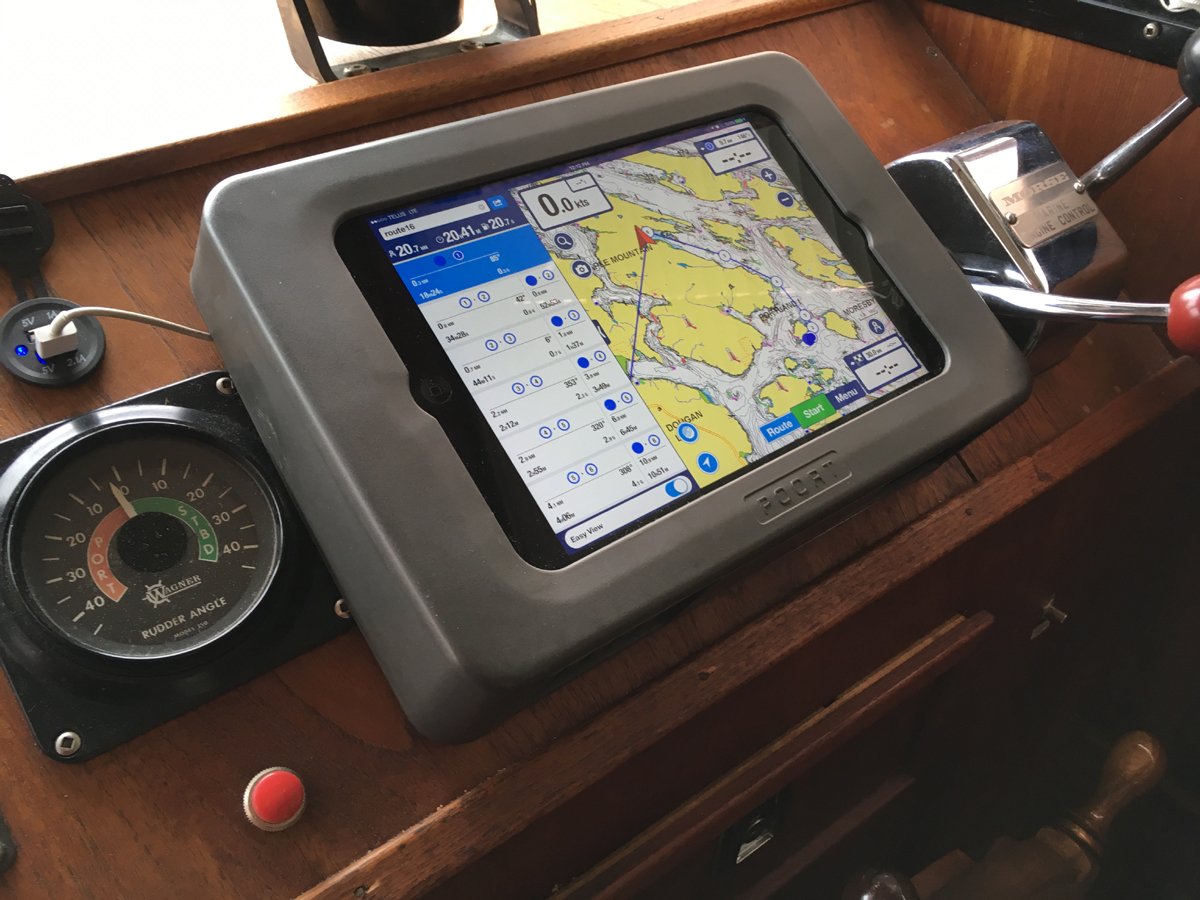
I started out using my iPad as a back-up to my Garmin GPSMAP-942xs, but for a couple of years now, I've been using my iPad Pro 12", running iNavX with Navionics charts. I like the larger presentation and the Navionics charts have more readability & detail here in the Salish Sea waters, IMHO. I have the NOAA charts loaded, but seldom use them. AIS is presented on the Garmin and is available on the iPad, via WiFi.

I use a removable sunshade when needed, and plug the power cord into a USB port on the bridge. The bridge has a Sunbrella top, so I never experience loss of signal. I also appreciate the ability to sit in the main salon or at home while setting-up or altering waypoints and courses.

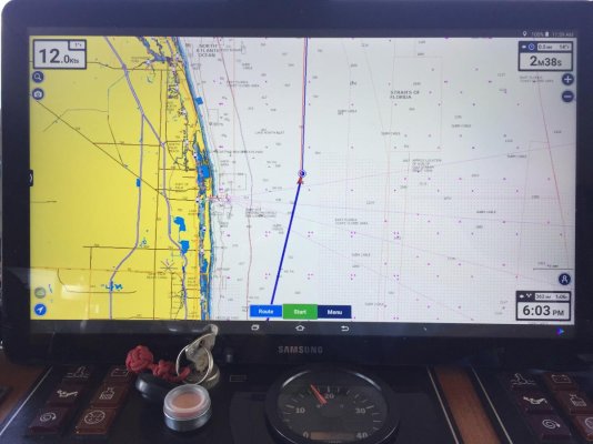
So, the Garmin has become the back-up and I keep it in the radar overlay mode, with the iPad as primary. Also carry paper charts, but they haven't seen the light of day for several years.
 
Works fine.

I have navigated the Chesapeake bay for 8 years using Navionics on a Google Nexus 10 tablet and later a Google Nexus 9 tablet, running in parallel with a Garmin Oregon Handheld navigation device for comparison, and later a fixed chart plotter already installed on my new-to-me boat.

They agreed the whole time except for one 3 minute period where I suspect I lost a satellite and could not see enough of them for an accurate fix.

For that 3 min, the chartplotter dead reckoned, but the nav program jumped me 5 miles off and put me over land. No worries! I could see land on both sides of the bay and was piloting as my main nav method anyway.

My conclusions:
1. Over 8 years testing, 3 minutes of bad data is sufficiently reliable.

2. Nav programs on good COTS hardware are as accurate as chartplotters.

3. NOTA BENE: Your experience with other hardware and other waters may vary.

4. Conclusion: These machines are your helpful advisors, and nothing more. Bad data produces bad advice; they can't tell the difference. You are still the ultimate authority on your boat and bear the responsibility of knowing exactly where you are at all times, regardless.
 
How many are using a tablet as their primary GPS Navigation tool? If so have you found any significant limitations?

I use an older iPad Air with GPS chip and Navionics, in a Poort enclosure connected to a cigarette lighter dash outlet, converted to USB. I take it up top and hang it vertically for better sun tolerance and readability. No issues ever.

Fit.jpg
 
We have had an iPad with built in GPS running Navionics in parallel for 4 years, and over 16,000 nautical miles. This summer we were in the Rideau Canal and lakes, St. Lawrence Seaway and Chambly canal. It was our primary chartplotter, as we did not have Canadian charts for Coastal Explorer. Once we returned to the US I noticed we are relying on it even more. I always plot a route in Coastal Explorer but use the auto route function to time my approach to bridges and locks.
 
After reading all the posts here I decided to make my iPad my primary GPS Chartplotter. I have run iNav-x for years but on the advice of many just switched to Navionics. What an improvement. Very happy with this set-up! Thanks for all the feedback and advice. :thumb:
 
One downside...

On our last boat (33ft. express) I searched for a back-up to the dated electronics installed on the boat when we purchased it (2017). I came across the Galaxy View with a massive 18.4" touch screen that was surprisingly daylight readable (not so much in direct sun). At the time it was on clearance at Best Buy for $380! I should have bought more. Samsung discontinued the model. They have a 17" replacement model soon to be released.

https://www.androidauthority.com/samsung-galaxy-view-2-2-901992/

It has built in GPS and Wi-Fi. I added Navionics app and was off and running. It was relay amazing and quickly became my main electronic nav aid. Never a glitch running the entire Chesapeake Bay all season.

When we purchased our new (to us) trawler (8/2018) in Ft. Lauderdale, I brought the tablet aboard for our trip north to the Chesapeake. The boat has 2 completely separate Nobeltec computer systems ($20k+ when new) and I would put the Tablet system on par. Exception being the radar interface with the Nobeltec. We basically ran each of the 2 radars (diff. ranges) on the 2 computer systems and the Tablet doing the nav/chart plotting. We ran offshore from Port everglades to Charleston, then inside. Never missed a beat and kept us off the bottom.

Now, one downside that I have found using a tablet/app system, is that a lot of other people are using it too. In an area like the Chesapeake Bay where a lot of boaters are transiting between the same origins/destinations, using the auto route function of the app generates the same route to all users. This is essentially creating "roadways" on the water that most users follow. I know that channels are essentially water roadways, but I am talking about transiting across the bay or between major channels. As an example, auto routing between Baltimore Harbor and the Elk river will generate a route out of the Patapsco to the East of Hart Miller up to Pooles Island before joining the ship channel north. My experience on crowded days is that everyone is following the exact same routes. At trawler speed it is a lot more noticeable getting closely passed by planning speed boats. I have found that by changing the "boat settings" to have a significantly deeper draft will generate a less traveled route.
 

Attachments

  • 1ADA027B-806D-4529-8ADB-345FA9A63FDF.jpg
    1ADA027B-806D-4529-8ADB-345FA9A63FDF.jpg
    118.8 KB · Views: 74
  • PB210005.jpg
    PB210005.jpg
    125.9 KB · Views: 81
After reading all the posts here I decided to make my iPad my primary GPS Chartplotter. I have run iNav-x for years but on the advice of many just switched to Navionics. What an improvement. Very happy with this set-up! Thanks for all the feedback and advice. :thumb:

Which App are you using? What are the improvements compared to iNavX?

I'm presently using the Navionics 2XG charts in iNavX...is the charts update cost similar in the Navionics App (usually around $49 with Fugawi)?

Thanks
 
Since Irma blewout all of the electronics on my new boat, I utilized my iPad running Navionics with Raymarine WiFi chartplotter/sonar to overlay sonar and depth for a 1400 trek from Goodland FL to Green Turtle Bay. They worked flawlessly.
 
It sure would be nice to see iPads (tablets) replace MFDs with better NMEA and Radar integrations. I supposed however that's not in the best interests of the major MFD companies.
 
I purchased my first boat in Clearwater fl. I live in New Jersey. I hired a captain to help me bring her up. I learned a whole lot from him. But the best things I learned is the confidence I got when learning how to navigate with his iPad and the Navionics program. I got multiple Garmin’s up and down. But whichever I use the iPad/Navionics program is with me. When traveling I lay out courses, marinas to stay at, restaurants, shopping...... all while resting at anchor for the night
Won’t leave home without it! Seriously
 
Need to know.....
Taking off this coming Saturday to Florida. I’m thinking about (weather permitting)leaving cape May to OCean city Maryland. Can’t find much info after O.C. If anyone is familiar heading south I would like to know if anchorage s are good for the rest of the way to ground zero. Ty in advance
 
Use two ipads...connected via wifi to the rest of the boat

Brought Oma up the Mississippi and Illinois +++ to chicago. Primary navigation was using two Ipads - both using the internal GPS of the AIS. Around Lake Michigan I use iNavx On the waterways I used Aqua Map (Integrated Active Captain and the NA Charts were about 1/4 of the price.)
On the rivers One ipad was set to AIS, the other to Aqua.

On Lake Michigan Generally use both in iNavx, since it integrates AIS on the display. The 2nd iPad is generally used as a longer distance/wider view.

I am working to get the rest of the boat to talk to the iPads - the data wire was cut on the Depth/Speed , but will reconnect and should have that displaying on the iPads next season along with the autopilot and fluxgate. Not sure why I would use anything else (Life Proof cases and connected to the ships power)

I am still trying to figure out where to mount permanently - currently they get secured on the old MFD that that only uses the GPS coming through a wired connection to the 0183 network, with very poor maps, so it is basically a paperweight

I am thinking of mounting them overhead so looking at them is a look up instead of a look down...Low priority winter project....

Just my .02 worth
 
You guys have me looking at tablet computers now. I may have to buy a cheapo android to test the waters. Then move on to the more lux models with more features, doodads, and gizmos.
 
Ben. You won’t get let down. Navionics’s has a simple $14.99 download. It’s easy to use and one that I started with. The next year I upgraded to around $50.00 a year. And it nice to be able to plan a nice trip from home.
 
You guys have me looking at tablet computers now. I may have to buy a cheapo android to test the waters. Then move on to the more lux models with more features, doodads, and gizmos.


My comment may seem stupid but if looking to a cheap android tablet be sure it has GPS, some does not.

L
 
Ben. You won’t get let down. Navionics’s has a simple $14.99 download. It’s easy to use and one that I started with. The next year I upgraded to around $50.00 a year. And it nice to be able to plan a nice trip from home.


:thumb:Sounds like a good place to start.


My comment may seem stupid but if looking to a cheap android tablet be sure it has GPS, some does not.

L


Thanks for the heads up. I noticed that last night when I was browsing tabs.


My 15 years old clued me into the tabs reference. When I was his age, tabs was a slang term for pills.
 
I have been using Garmin Blue Chart on my older IPad for a few years and it seems OK. I have liked the easy integration with Active Captain, but I haven’t used it since the Garmin/AC buyout. Is it still the same?

Is Navionics better?
 
It sure would be nice to see iPads (tablets) replace MFDs with better NMEA and Radar integrations. I supposed however that's not in the best interests of the major MFD companies.


There are two problems with using an iPad or tablet as the display for a chart plotter: visibility in direct sunlight and water resistance. Both of these are less applicable for a pilot house installation.


David
 
I have no electronics at my lower helm. I use an iPad with a Garmin GPS app. I can use a Raymarine App to display mirror from the Display on the upper helm onto the iPad as well.

My wife uses the iPad as a secondary GPS for navigation.
 
A comment from a rep at the recent boat show said if you like the Navionics app better buy it now. Supposedly Garmin is about to "do something" to it in the near future...
 
I have used charting apps on android devices for quite a while. One thing I haven't seen mentioned is use in enclosed wheelhouses and good connection to satellites. The built in gps receivers often do work inside but I wonder about accuracy when they might not be receiving as many satellites as you would outside.
 
Unless it is a steel boat, fiberglass is quite transparent to the signals involved in GPS communication.


I did have a problem with getting a GPS fix while on a steel ferry even sitting near a window. Steel does block the signals.


David
 
I have used charting apps on android devices for quite a while. One thing I haven't seen mentioned is use in enclosed wheelhouses and good connection to satellites. The built in gps receivers often do work inside but I wonder about accuracy when they might not be receiving as many satellites as you would outside.


I've only used a Bad Elf dongle on my iPad. My experience in the pilothouse is that it can take a few minutes to establish good satellite connections, but that once established it generally maintains good connections and accuracy. Not as good as my Raymarine plotter with the 125 GPS antenna, but pretty good.
 
Ipad/Bad Elf with Navionics is primary for entering new harbors with numerous turns, or for changing destination quickly. Secondary at all other times. Don't leave it in the sun. It simply shuts down when overheated.


What is Bad Elf?
 
We use an iPad and a T-box for a transducer with Navionics running on the iPad. It works great because the Vexilar T-box is a transducer wired to a little black box (the T-box part). The black box sends out a network signal that you can connect the iPad to (or any mobile device). This way you can run Navionics on your iPad plus have a live feed on depth and sonar... essentially turns your ipad into a full fledged fish finder and chartplotter for 5% of the price. Vexilar t-box is about $150 and Navionics for iPad is about $50.
 
We use an iPad and a T-box for a transducer with Navionics running on the iPad. It works great because the Vexilar T-box is a transducer wired to a little black box (the T-box part). The black box sends out a network signal that you can connect the iPad to (or any mobile device). This way you can run Navionics on your iPad plus have a live feed on depth and sonar... essentially turns your ipad into a full fledged fish finder and chartplotter for 5% of the price. Vexilar t-box is about $150 and Navionics for iPad is about $50.

Do you have the T-Box mounted internal/inside the hull or external on the transom? I can't find any info on the hull thickness limitation of the internal mount T-Box install.
 
Last edited:
I have used charting apps on android devices for quite a while. One thing I haven't seen mentioned is use in enclosed wheelhouses and good connection to satellites. The built in gps receivers often do work inside but I wonder about accuracy when they might not be receiving as many satellites as you would outside.


Our several tablets and the laptop in the saloon always seem to be spot-on compared to our built-in plotter.


What is Bad Elf?

A plug-in GPS product, for use with devices that don't have built-in GPS sensors. There are others, too...

-Chris
 

Latest posts

Back
Top Bottom