Quick Question on Nav Charts

The friendliest place on the web for anyone who enjoys boating.
If you have answers, please help by responding to the unanswered posts.

jovial_cynic

Veteran Member
Joined
Aug 20, 2017
Messages
83
Location
USA
Vessel Name
Zorro Del Mar
Vessel Make
1972 Tollycraft Tri-Cabin
I've got a lot of reading to do, but I wanted to confirm something.

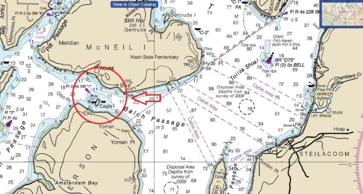
At some point, I'll be taking my boat from Bremerton down to Olympia, so I grabbed a nav chart and was considering different routes. I'm really aiming for the shortest trip, so I initially thought I'd go between McNeil and Anderson Island. Am I understanding correctly that the depths between the islands (in the circled are) is only 11ft at the deepest point?

Based on an experienced glance at the chart, would you avoid that route? Or is that perfectly fine? I have no interest in doing anything terribly difficult on this first trip.
 

Attachments

  • islands.jpg
    islands.jpg
    164.4 KB · Views: 221
You should be fine. I see 55-66 feet on my Garmin Charts with 33' on the south shore of McNiel.
 
Last edited:
Your depths appear to be in fathoms.
My Navionics app on my phone shows 64ft where yours shows 11 fathoms.

Also, that is white, so always staying in the white will see you at least in deeper water than you need.
 
Oh, speaking of garmin and other necessary tools - any great recommendations on navigation tools? In 2017, are there phone apps that are up to par with the commercial units out there?
 
feet, fathoms... :facepalm:

Sigh. So much to learn.
 
In 2017, are there phone apps that are up to par with the commercial units out there?
In the Google Play Store or Apple equivalent, Navionics Boating HD is a commercial app that we use, sometimes as a backup, sometimes as the primary nav source.

Edit: Noting that you're PNW, I should qualify that we've used it solely on the east coast and in/around the Chesapeake Bay and have found it accurate and acceptable as a primary nav guide. Can't vouch for it in the PNW.
 
Last edited:
Mr. Cynic,
I noticed on the screencap you posted there is a "View in Chart Catalogue" icon at the top of the image. I'm guessing you could open that to view the properties of the chart you're viewing. That, or some other way to show the chart properties should indicate conclusively the unit with which chart is indicating depth. It's easy to mis-read until you become familiar with the charts. Even more so, some of the electronic charting may read different units of depth at different zoom levels. Nice! The CHS charts we're using up here in the North Channel can be in all three- meters/feet/fathoms - depending. So if something seems off, go to the chart properties to confirm.

All that being said, if you draw 6 ft, regardless of the units of measure, if you're seeing >"6" on the chart, you're pretty much good to go even if you mis-read the units!
 
Last edited:
Balch Passage is a very easy and safe way to go. There is a Green Marker that stands on a rock. Leave that to Port and you are golden.

BTW, unless it has been mentioned in another reply, the depths listed on that chart are in fathoms and feet. 11 fathoms of 66 feet.

Edit: Yeah the above was mentioned already. Sorry.

As for apps, I would look at SEAiq. I believe it is free if you use the NOAA charts and has Active Captain incorporated into it. For Puget Sound waters it is great for basic planning etc...

I also have the Navionics app for iPad and it is OK. I've yet to be really happy with any iPad app and much prefer my chart plotter for electronic charts. However, the iPad charts are great for planning when away from the boat. FWIW, I also recommend having paper charts for your waters. Many here will disagree however and claim they an unnecessary anachronism.
 
Last edited:
feet, fathoms... :facepalm:


Sigh. So much to learn.


Just the fact that you are "Planning" your trip shows that regardless of your experience you are a savvy and prudent vessel owner.
My point being that with diligence comes a life of boating without the mishaps we see in the news.
Have a fun trip.
[emoji106][emoji41][emoji106]
 
feet, fathoms... :facepalm:

Sigh. So much to learn.

Don't worry about it Mate. You will get the hang of it. All of us are still learning! :thumb: That is why we have this forum.

Cheers.

H.
 
What others have said. That looks to me to be a NOAA chart. If electronic, the info on depths and heights will be on the "Title Block" on the chart, and probably also by accessing an "Info" icon somewhere on the chart. It's important you look because in Canada, the Canadian Hydrographic Charts,depending on their vintage, may be either in fathoms and feet or in metres.
 
Oh, speaking of garmin and other necessary tools - any great recommendations on navigation tools? In 2017, are there phone apps that are up to par with the commercial units out there?
The Navionics app (available for Android or iphone/iPad) is not only a great navigational aid but also offers a feature called auto routing. You click on the chart where you want to go, set your boat settings (such as how much you draw) and it calculates a safe route for you... Really cool feature!
 
The Navionics app (available for Android or iphone/iPad) is not only a great navigational aid but also offers a feature called auto routing. You click on the chart where you want to go, set your boat settings (such as how much you draw) and it calculates a safe route for you... Really cool feature!

I've started using it - it's pretty great. I did find out, however, that there's a weird nuance that's built in that makes using the app across two devices a bit of a pain.

The app allows you to purchase the full version without creating a Navionics user account. If you do that, your username won't be linked to the purchase, meaning that later downloads on other devices won't register the fact that you've paid for it.

So... you have to create an account, log in, and THEN purchase the subscription. When you download the app onto another device and log into your account, your purchases will link up.
 

Latest posts

Back
Top Bottom