While I see nothing to indicate fatigue did cause this incident, I completely agree with comments on fatigue. Many people are convinced they function well at less than recommended sleet but every test and study conducted proves conclusively they don't. I once was driving home on a 300 mile trip returning from business. I'd always said, I'd drive home at night but I was going to stop the moment I felt too tired to drive. I stopped that night and got a motel room less than 30 miles from home, but that's when it hit me and the moment it did I pulled off at the next exit.
You are using an out of date browser. It may not display this or other websites correctly.
You should upgrade or use an alternative browser.
You should upgrade or use an alternative browser.
Nordhavn salvage
- Thread starter psneeld
- Start date
The friendliest place on the web for anyone who enjoys boating.
If you have answers, please help by responding to the unanswered posts.
If you have answers, please help by responding to the unanswered posts.
dhays
Guru
- Joined
- May 26, 2015
- Messages
- 9,045
- Location
- United States
- Vessel Name
- Kinship
- Vessel Make
- North Pacific 43
I have made errors based on fatigue, carelessness, ignorance, and inattention. Fortunately, none of my errors have resulted in injury or loss of a boat. However, those errors that I became aware of (I am sure there are many that I never recognized) were learning experiences. I tend to be be pretty understanding of the errors of others since I recognize them in myself.
I agree with whomever said it earlier in the thread, there are no accidents, only errors that turned out badly. At times there can be equipment failures, but in most cases those can be traced to prior errors on someones part. Often a poor outcome is the result of an accumulation of small errors.
I agree with whomever said it earlier in the thread, there are no accidents, only errors that turned out badly. At times there can be equipment failures, but in most cases those can be traced to prior errors on someones part. Often a poor outcome is the result of an accumulation of small errors.
man n black
Veteran Member
Chain of events that lead to a poor outcome...
Ch
Ch
OP
OP
psneeld
Guru
what chain of events?Chain of events that lead to a poor outcome...
Ch
the only info I have seen so far is a light cruising day with nothing to note, a grounding, and a salvage that had a bad outcome.
but that's not a chain of errors that led to the initial grounding.
OP
OP
psneeld
Guru
or just keep going here if we all want....doubt we will find out much more about the original grounding.Agree that so far there is no indication that fatigue was a causal factor. Topic for a new thread.
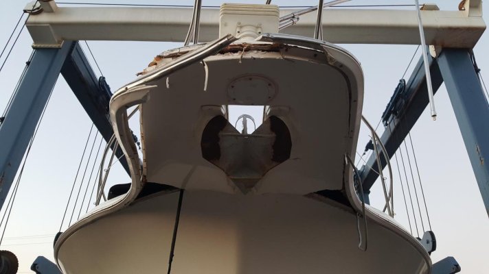
Here's what the bowsprit of that Silverton I mentioned earlier that sank looks like. The really dark spots are holes or wide cracks...opened like a can a beans at a campfire....

I will bet this one had an accident chain longer than ....well if I get into chain someone might think this is really an anchoring thread...
Attachments

Last edited:
hollywood8118
Guru
- Joined
- Nov 16, 2009
- Messages
- 2,379
- Location
- USA
- Vessel Name
- " OTTER "
- Vessel Make
- Ocean Alexander Europa 40
or just keep going here if we all want....doubt we will find out much more about the original grounding.
Here's what the bowsprit of that Silverton I mentioned earlier that sank looks like. The really dark spots are holes or wide cracks...opened like a can a beans at a campfire....
I will bet this one had an accident chain longer than ....well if I get into chain someone might think this is really an anchoring thread...
I wonder if that had been previously stressed by reefing in on the anchor windless too much..
HOLLYWOOD
Do yall think he hit the levee (or whatever it was) because he was relying only on electronic charts? Would paper charts have made a difference?
There are many examples of the use of vector charts zoomed out too far to show a detail, that have put some boat onto a hazard. The beauty of vector charts is that when zoomed out, there is less clutter, as the detail of a closer zoom is dropped as you go out. That comes with a significant price if you don't frequently zoom in to see what has been dropped from your view.
I am not saying that was the problem in this instance but we can all learn from making the assumption that it may have been.
One of the best, most publicized examples of this characteristic of vector charts is a round the world sailing race of a couple of years ago, where, in a part of the Indian ocean thousands of miles from anywhere, one of the race boats, ( iirc they were all using the Volvo Open 60), ran headlong onto a reef. Lots of damage done. The navigator admitted he hadn't zoomed his charts in, as they were so far from any land he didn't feel any need to do so.
OP
OP
psneeld
Guru
maybe, don't think so with the size/type of the anchor, the type of boat and seeing the owner and crew around the dock...wonder if they ever have seriously anchored....I wonder if that had been previously stressed by reefing in on the anchor windless too much..
HOLLYWOOD
my guess looking at this particular model, that duckbill like forward part, almost too wide too call a "sprit", being slammed into a short, choppy headsea for an hour may have been all it needed.
No facts here...but my guess is it may have loosened...the boat started taking on water, they couldn't locate the source and actually sped up to make port, which in turn did more damage.
just a 2 beer theory, might have to have 3 one day this weekend and see if my theory changes....
Last edited:
ranger58sb
Guru
Please see post #91 regarding raster, vector, paper charts for the area. It's simply a non-issue in this case.
Yep, saw that later, seems correct, non-issue.
-Chris
twistedtree
Guru
Here's the owners first hand account of the accident.
-----
Back in mid-August we promised an update once we got things sorted out. If you are still interested in an accounting of the event and its aftermath, click on these links:
08-Aug: Ghost Rider Down
15-20 Aug: Ghost Rider Salvage Ops
-----
Back in mid-August we promised an update once we got things sorted out. If you are still interested in an accounting of the event and its aftermath, click on these links:
08-Aug: Ghost Rider Down
15-20 Aug: Ghost Rider Salvage Ops
OP
OP
psneeld
Guru
Nice to hear a first hand account that sounds honest.
Interesting that the owner felt that vector charts while still showing the dike...just didn't punch enough for anyone to catch it.
Interesting that the owner felt that vector charts while still showing the dike...just didn't punch enough for anyone to catch it.
We've had a few "mis-interpretations" by vector charts. After a Navionics chart led us right across a ledge (stopped the boat but no damage!) we never fully trusted them again! My wife always has a paper chart out for reference now.
I'm inclined to go with the Rastor charts included with the Furuno system but we will see... vector charts are nice to use when they are accurate.
Bruce
I'm inclined to go with the Rastor charts included with the Furuno system but we will see... vector charts are nice to use when they are accurate.
Bruce
twistedtree
Guru
For what it's worth, I checked out the NOAA vector charts, and they show the dyke, but I could see how you might mistake it for a range line or light sector line.
I then looked at the c-map chart, and it's even more subtle, and I think would be even easier to miss.
But I still think the lessen here is that we are all fallible, and as soon as we start thinking "I would never make that mistake" it's just about the time when you will make a blunder.
I then looked at the c-map chart, and it's even more subtle, and I think would be even easier to miss.
But I still think the lessen here is that we are all fallible, and as soon as we start thinking "I would never make that mistake" it's just about the time when you will make a blunder.
Very painful to read but great warnings to all of us. Also, a reminder that it still can happen, doesn't matter how good we are, it just takes one little mistake or omission and sometimes might not even be that. The task is handling the aftermath. Anytime a boat is lost and no one gets hurt, that's positive. I'd just say one thing to the owners who I doubt are reading. I don't know what I'd do after such an event. However, with a love of cruising and boating such as you had, it's a shame if this ends all those dreams. A car gets totaled and we don't stop driving forever and driving cars isn't even fun. However, driving cars is a necessity for most. Well, enjoying your passion if you can is also a must. If boating just isn't it for you anymore, be sure you find something else to fill the void and maybe even be better.
One thing I have learned about rituals and patterns you want to follow is to have written check lists where you actually have to check it off as you do it helps. Today it's often a computer check list with us, but it requires every box c checked and digital signature.
- Joined
- Jun 25, 2008
- Messages
- 10,104
- Location
- Australia
- Vessel Name
- Now boatless - sold 6/2018
- Vessel Make
- Had a Clipper (CHB) 34
One thing that came out of the reef stranding of that Volvo round the world race yacht ( Team Vestas) a couple of years ago, where they grounded on what was, in effect, a small coral island near Madagascar, was that details that are actually potentially visible, may not be if you are zoomed out a bit much, and forget to zoom back in for more detail. That being the big advantage of the paper chart of course, in that not having zoom functions, they have to show everything.
Volvo Ocean Race Team Vestas
Volvo Ocean Race Team Vestas
roguewave
Guru
- Joined
- Jul 7, 2012
- Messages
- 642
- Location
- Texas
- Vessel Name
- bout’ time
- Vessel Make
- Grady White 282 Sailfish
 This was me, in the 17ft whaler, in heavy fog navigating with my iPad/Garmin chart last week. Not my proudest moment to share but things can and do happen. Fortunately I caught it before running aground.
 The combination of heavy fog, glasses coated with fog water, being alone, having the screen on too large of a scale and the desire to get home almost cost me. Instead a valueable lesson was learned.
***The boat shows being on land because I didn't turn off the recording till I got in the house.

Last edited:
twistedtree
Guru
One thing that came out of the reef stranding of that Volvo round the world race yacht ( Team Vestas) a couple of years ago, where they grounded on what was, in effect, a small coral island near Madagascar, was that details that are actually potentially visible, may not be if you are zoomed out a bit much, and forget to zoom back in for more detail. That being the big advantage of the paper chart of course, in that not having zoom functions, they have to show everything.
Volvo Ocean Race Team Vestas
I would respectfully disagree that paper charts are the only solution. Most chart plotters can display raster charts as well as vector charts. If you switch to the raster charts, you see exactly what's on that paper chart. So in this example, it's paper or electronic raster chart would show you the same thing.
But even that's not the problem. The issue is that charts at different scales show different levels of detail, and this is true for paper, raster, and vector charts alike. There are lots and lots of large scale paper/raster charts that don't show critical hazards, where the smaller scale chart of the same area does show the details.
So I think the real issues is that you need to check your route at various scales, down to the smallest, to ensure you see everything. This is true with all chart types. I would argue that with electronic charts it's much easier to switch scales vs digging out more paper charts. Where vector charts can lure you into trouble is that the source data has many scales, where raster charts might have 2 or 3 for any given area.
Greatlaker221
Senior Member
I wonder why they did not get as many big bags under it asap to try and unground asap on the falling tide, if/once unsuccessful another opportunity to bag it and float it with the rising tide. Sounds like they focused on pumping more then flotation. It would take a lot of 6000# bags for that size boat. ah well, easy to say in a warm armchair. Interesting case.
caltexflanc
Guru
I would respectfully disagree that paper charts are the only solution. Most chart plotters can display raster charts as well as vector charts. If you switch to the raster charts, you see exactly what's on that paper chart. So in this example, it's paper or electronic raster chart would show you the same thing.
But even that's not the problem. The issue is that charts at different scales show different levels of detail, and this is true for paper, raster, and vector charts alike. There are lots and lots of large scale paper/raster charts that don't show critical hazards, where the smaller scale chart of the same area does show the details.
So I think the real issues is that you need to check your route at various scales, down to the smallest, to ensure you see everything. This is true with all chart types. I would argue that with electronic charts it's much easier to switch scales vs digging out more paper charts. Where vector charts can lure you into trouble is that the source data has many scales, where raster charts might have 2 or 3 for any given area.
Right on. And, the captain of the ill-fated Nordhavn says the same thing and offers no excuses, taking full accountability for what happened. As I said in an earlier post, there are reasons why it happened, but no excuses. A chartbook does make it so easy to review a route, much easier than futzing with zooming a little screen.
OP
OP
psneeld
Guru
I am not sure.....but I think the main difference between vector and raster zooming is there is a definitive jump in chart detail on raster where on vector, the zoom is infinite and when detail is lost might be less apparent to a personunfamiliar with an area or relatively inexperienced.
If zoomed in enough...no big deal, if zoomed out both chart types will drop features....the trick is what zoom level is appropriate for the area and style of navigation you are attempting.
In this case, using a chart to navigate down the river need only show the channel marks if using the channel if in a 60 foot vessel compared to a 600 foot vessel.
Leave the channel and now you best be using the largest scale chart you can get to and go at the appropriate speed if unfamiliar waters. If there is no marked USCG channel, best to also have reviewed the notice to mariners for that area. Not that I always do that...as often a simple scan of the area gives the flavor of how complicated nav should be. But that still leaves you open to uncharted or poorly charted/marked hazards.
That's why I have stuck with raster charts....my navigation habit patters are used to them and subconsciously must make subtle decisions that I can't say I am aware of. That does not mean that someone good with raster charts couldn't easily be a better navigator with them.
The posters that brought up double checking your work, especially when navigating in unfamiliar waters out of clearly marked channels make one of the most important points.
sunchaser
Guru
- Joined
- Apr 9, 2008
- Messages
- 10,194
- Location
- usa
- Vessel Name
- sunchaser V
- Vessel Make
- DeFever 48 (sold)
Yup PS, you nailed it.
Maybe I missed it in this long thread - are there not buoys in this area marking the channel?
Another comment, Nordhavn or other high end boaters are not necessarily any more diligent, just with bigger wallets. Bottom line though, lots of Tesla auto guide mentalities in the boating world. Look how often many set an auto pilot on Navigation and sit back seldom looking at the charts in detail whether paper or electronic.
In the old days when boating on the Mississippi, every spring we yakked about what the corp had done over the winter for jetty and dike building. New man made hazards were common. But, after a boozy weekend lots of mishaps occurred, I was equally guilty of hitting a new sand bar and filling the strainers - ouch.
Sealife
Guru
Simple solution to the chart debate. I run two plotters, one zoomed out and one zoomed in. I even use different software to cross check by changing which is in and which is out. Works great. Even if your second plotter is just an iPad.
Picked up this trick doing delivery, when I brought my own nav. equipment as backup and the vessel had it's own which continued to work.
Picked up this trick doing delivery, when I brought my own nav. equipment as backup and the vessel had it's own which continued to work.
Last edited:
Gdavid
Guru
I like raster charts that are NOAA sourced, they look exactly like my paper charts and it is very clear when I have zoomed in when it switches to a different chart. I use Memory Map on my android devices and really like it, the app is free but you pay for their proprietary charts which are just a unique file type from NOAA rasters, $15-20 buys you the license for the current year complete catalog of NOAA charts and you download the ones you need. The hardwired navigational equipment is Garmin running vector charts and it just isn't my cup of tea.
Last edited:
Simple solution to the chart debate. I run two plotters, one zoomed out and one zoomed in. I even use different software to cross check by changing which is in and which is out. Works great. Even if your second plotter is just an iPad.
Picked up this trick doing delivery, when I brought my own nav. equipment as backup and the vessel had it's own which continued to work.
 yup run one with the radar overlay at an appropriate range for conditions.... The other one displays the area of interest, then I have my wife that prefers paper charts...
cardude01
Guru
- Joined
- Nov 26, 2012
- Messages
- 5,290
- Location
- USA
- Vessel Name
- Bijou
- Vessel Make
- 2008 Island Packet PY/SP
Simple solution to the chart debate. I run two plotters, one zoomed out and one zoomed in. I even use different software to cross check by changing which is in and which is out. Works great. Even if your second plotter is just an iPad.
Picked up this trick doing delivery, when I brought my own nav. equipment as backup and the vessel had it's own which continued to work.
That's what I do as well. I have my Garmin plotter zoomed out a bit and the iPad chart (also Garmin however) zoomed in for detail.
But I still run aground from time to time. ?
Question:
Would a steel boat have possibly survived a grounding like that Nordhavn? I've heard people say you can run a steel boat (I think they were talking about a Diesel Duck at the time) onto a coral head and it will survive.
A chartbook does make it so easy to review a route, much easier than futzing with zooming a little screen.
Only for those of you who grew up in the paper generation. I don't have to futz. Plus my screen isn't little.
Now as to the other comments, we always have two different systems in use and we do the double checking that was referred to, but we have a check list to make sure we do. Prior to the start of the leg, we check the charts thoroughly and note all potential issues. We also check possible deviations from plans. If, in the course of the day we decide to change our plans entirely, we repeat the process. The real work is done before you start cruising, not while cruising. While cruising you use the information you saw earlier and combine it with what you visually see now. The owner had a good system in place, just failed to use it that time. The owner did an excellent analysis. This wasn't an accident due to failure to see the jetty. It was due to failure to follow their procedures, designed to prevent failure to see accidents.
As to whether steel or aluminum would have survived, due to the nature of the major damage as it being weight more than just an initial impact, I think they would also have had serious problems.
Then the talk of whether more flotation earlier might have saved the situation. It might have helped, but there was already some serious damage developing long before the water inflow and before it was known. The stress under the boat didn't just happen at once. It became known at once though. And, I toss something else out. The owner noted the time at which it became strictly salvage. There's an earlier point that I would have no regrets it wasn't saved. There were signs of structural hull damage, although not clearly understood at the time. However, let's say you save the boat from sinking completely but you have a hull with serious structural damage from the stress of the weight, do you really have anything at that point that you care to recover? Would you have had more of a battle getting the insurer to declare it a total loss? I don't know when the time was but there was a time some hours after the boat sat as it did, that unknown to everyone at the time, the hours of stress made it something I wouldn't have wanted to have tried to restore. In fact, this is the reason in most damage claims that items are declared total losses when the cost of repairs exceeds a certain percentage, such as 75%, not when it's 100%. Yes, there are people who could have restored it but basically they're boat builders and would have been rebuilding not repairing. Then it's not the boat it was, might be a better version or worse version, and it's a boat with a lot of bad history.
Crusty Chief
Guru
This was a tragic loss and I applaud the couple for taking the time to post this mishap. Not sure I would feel up to posting an incident like this given that they lost a very nice boat and owning up to not only the cause but the end result.
If only more people in this world would accept responsibility for their actions as this couple did. I hope they can get over this and at some point find another boat to continue on.
If only more people in this world would accept responsibility for their actions as this couple did. I hope they can get over this and at some point find another boat to continue on.
Similar threads
- Replies
- 83
- Views
- 10K