Little Mud River, GA

The friendliest place on the web for anyone who enjoys boating.
If you have answers, please help by responding to the unanswered posts.

boathealer

Guru
Joined
Aug 31, 2017
Messages
1,190
Location
US
Vessel Name
--
Vessel Make
Between boats
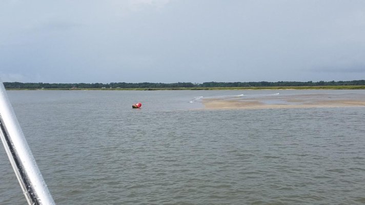
Went through Little Mud River, GA on the ICW today at dead low tide (0.0). Followed the deepest parts shown on Navionics Sonar charts. Saw LOTS of 4-4.5ft for the long shallow stretch. Dipped to 3.3ft a couple of times - pretty sure the drug the skegs a bit through those.

I guess I should have known it would be slim when I turned past this on the way in:
 

Attachments

  • 20190503_132918 (Large).jpg
    20190503_132918 (Large).jpg
    83.8 KB · Views: 75
Last edited:
Little Mud River is best avoided at low tide. There is more than 5' at low tide, I've made the mistake and went through without touching. If you find yourself there at low tide again, running the outside third of the curves will almost always put you in the deepest water. For the Little Mud, this sort of resembles waterskiing from side to side.

Ted

OC - When is the last time you were through there? I'm not sure there is 5ft anywhere in that section at 0.0 low water as of today, based on my hunting around. Neither would the two larger trawlers that I passed, both hard aground and stationary. Navionics sonar confirms your 1/3 theory....

r.
 
OC - When is the last time you were through there? I'm not sure there is 5ft anywhere in that section at 0.0 low water as of today, based on my hunting around. Neither would the two larger trawlers that I passed, both hard aground and stationary. Navionics sonar confirms your 1/3 theory....

r.

We also passed thru there yesterday, but at close to high tide, and can confirm your numbers. But the bottom is very soft mud, so many skippers will just power thru it.
 
OC - When is the last time you were through there? I'm not sure there is 5ft anywhere in that section at 0.0 low water as of today, based on my hunting around. Neither would the two larger trawlers that I passed, both hard aground and stationary. Navionics sonar confirms your 1/3 theory....

r.

Last time I was through was around the 18th of April (last month). Last time within 1.5 hours of low tide was late October of 2018. I draw 4.5'. The area that was shallower on my November trip was a little further South where the Altamaha river tributary (coming from "Two way fish camp") ties into the AICW. Lots of shoaling on the North side. They need to move the navigation markers East or dredge.

Ted
 
Back
Top Bottom